EASTER ISLAND - ANCIENT GATEWAY TO THE PACIFIC
ANOTHER HUGE, OPEN AIR UNIVERSITY FOR TEACHING PRINCIPLES OF NAVIGATION & CYCLIC ASTRONOMY
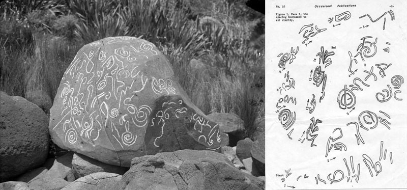
There have been centuries of speculation related to the purpose and function of the giant moai statues of Easter Island, arrayed as they are in lines on ahu platforms around the entire coastline or placed as individual, stand-alone monuments at multiple inland locations. In total, the number of moai approaches about 1000, with yet more being discovered from time to time to add to the known dossier. Coupled with the many complete and standing, or fallen and often broken statues, are many other kinds of surveying-related markers. These include large and hefty, incised or shaped stone obelisks and boulders, fabricated in a wide variety of designs. There are also purpose-built mounds and cairn structures, as well as cut plateaus on modified hill tops, where a series of incoming survey lines converge then resolve to one common point.
An experienced surveyor giving Easter Island the "once-over" glance, immediately sees all of the essential elements in place for a vast and sophisticated surveying complex, which has been methodically planned and laid out by adept masters of the craft. The multiple distance and angle tutorials encoded into the Easter Island landscape are, essentially, no different than what is found in the ground etched geometry of Nazca Peru, the North American geometric earth embankment complexes like the Octagon of Newark, Ohio, U.S.A., the standing stones and other purpose-built monuments in and around Avebury Henge of Southern England or the many code-bearing edifices of the Giza Plateau of Egypt, etc., etc. All were built as sprawling open air universities by the same confederation of cousin European nations. All encoded the same scientific principles related to methods of navigation or measuring the duration of cycles in astronomy. All values used and encoded into the landscapes of several continents, where the schools were built, were derived from the same integrated parcel of special numbers. It was upon this highly venerated parcel of "science preserved by numbers" that multiple, ages-old, Caucasoid civilisations were founded and maintained from remote antiquity. By the establishment of many open air universities across the world, the brightest and the best of a society's children were taught the special knowledge, such that it was passed down intact to each ensuing generation.
A point that will be established very vividly in this study is that none of the great stone statues or other kinds of surveying-related monuments at Easter Island were put there by the very late arriving, interloper Polynesians. They only inherited these impressive works as the spoils of war after they subdued and cannibalised the earlier Caucasoid civilisation that had lived there for many generations. By the time the moai builders were finally annihilated, it's probable that their great school had functioned, flourished and been added to continuously from, conceivably, as early as 2500 B.C., or within the historical timeframe of the tall, red-headed Lapita people and associated cousin groups of the ancient Pacific countries. The highly ornate design work of Lapita pottery will often depict the same Caucasoid facial type, with beards or moustaches, as found on Easter Island moai heads. Moreover, Lapita pottery has been located at Easter Island. It has also been found distributed over thousands of miles across the full expanse of the Pacific to Micronesia and some of the pottery or other artefacts and skeletal remains of these people dates to as early as 2500 BC. Whoever the Lapita people were, they were adept navigators and could range around the entire Pacific ocean at will. Their pottery carries the selfsame geometric design work (lozenges, chevrons, knops, spirals, etc.) as what is found on Beaker People burial pots of Neolithic Britain, with the selfsame or very similar design work appearing copiously throughout Central & South America. Although well preserved Lapita People skeletons have been found in several areas of the Pacific, publicly available reports on their physical anthropology are disallowed.
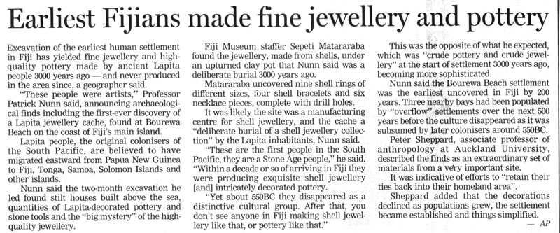
Yet another "Lapita People" archaeological find ... this time in Fiji. Article from The New Zealand Herald, Thursday, April 24th 2008.
Other anchaeologists and anthropologists comment on the "sudden disapearance" of the Lapita People and their highly decorated pottery, which, overnight was replaced by other cultural artefacts and some plainware pottery. The Lapita People were, quite obviously, overwhelmed by invaders who displaced and extinguished them.
Despite the patently obvious fact that the Lapita people were not the forebears to the Polynesians, that political wheelbarrow continues to be pushed by our experts (so-called) who commit huge "sins of omission" in what they let the public see or know about the "Lapita People". The issue of gross "dereliction of duty" on the part of our archaeologists and physical anthropologists, in their withholding of true Lapita findings from the public, was raised in 1998 by Author, Yuri Kuchinsky in an article titled, Polynesian Origins and Lapita Deception. See: http://www.trends.net/~yuku/tran/l23.htm
For an in-depth look at "Lapita" and a clinical review of the evidence to date (including DNA), go to Peter Marsh's comprehensive article at: http://users.on.net/~mkfenn/page6.htm
In addition to the above, the elongated, sharp, aquiline moai
facial type of Easter Island bears little or no resemblance to the general
mix of Polynesian head forms. The moai head-crowns were also adorned with
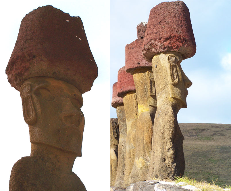
red lava-stone top-knots (pukao) to indicate the
tied bundle of head hair and its colouration.
Stephen-Chauver (1934, p. 18) gives the following description under the heading
“male coiffure” on Easter Island: “Formerly
the Easter Islanders always walked about bare-headed; their hair, regularly
cut above the ears (A. Pinart), was artificially rouged and united in a topknot
on the summit of the head, by the aid of plant fibres and a coating of mud.”
(See: American Indians in the Pacific,
by Thor Heyerdahl).
Some statues of South America show the same top-knot design.
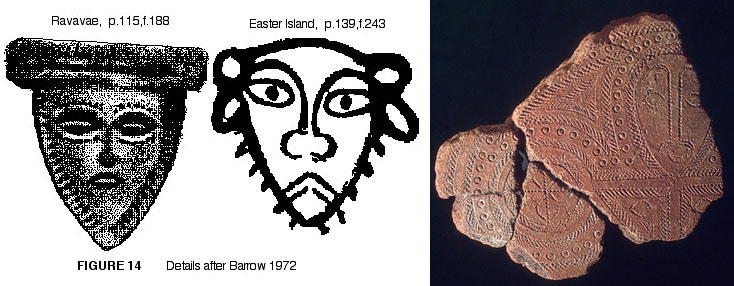
Faces depicted upon Lapita pottery, ranging across the entire Pacific from Micronesia to Easter Island. The faces and head-form are the European type and facial hair (beards, moustaches) are often displayed. The pottery fragment to the right shows a very European face with a moustache. Generally, the Polynesians were a beardless people or were unable to produce much facial hair ... like the west coastal indian people of Central and South America ( Maya, Aztec & Inca, etc.). Despite this, over 10,000 perfectly preserved ancient mummies of people with blond, red, auburn, brown and various other shades of European-type hair, have been exhumed in many areas of Central and South America. They show full European physical-anthropological and cranial attributes that differ markedly from the much later, so-called "indigenous" norm and their blood groups are European. This very unwelcome evidence is muted and never (nowadays) mentioned in modern scientific papers, as reference to such unwanted facts would spell "career-suicide" for any academic writer foolhardy enough to lay out the whole truth for public consideration.
The long thin faces of Caucasoid Europeans with the dolichocephalic cranial (cephalic) index, narrow beaked leptorrhine nose type, wide eyes, thin lips, small mouth clench and prominent chin (the sharpened edge aspect to indicate a full beard) without any indication of chin prognathism. The jawline on the lower border of the mandible is very flat or curves slightly upwards, consistent with a European jaw, whereas the Polynesians predominantly display the "Rocker Jaw", with it's continuous, pronounced downward curve on the lower border. The "Rocker Jaw" is the singly most important identifying feature of Polynesian physiology, occurring in up to 92% of cases. It's incidence at Easter Island amongst the native population is the lowest in Polynesia, showing that there was an early era admixture of a distinctly different racial type that came into the local Polynesian gene pool. This occurred long before modern day explorers found Easter Island in the 1700's and relates to early intermingling with the white, long-eared people encountered when the first Polynesians arrived.
The stone chosen to form the body of each statue is a tawny or very light tan colour, consistent with European skin colouration in sunny conditions. The question goes begging: Why would Polynesians laboriously carve and erect many hundreds of huge, hefty statues displaying physiological features of an altogether different racial-type, which bore no resemblance to their own people or revered ancestors? Why would they go to such trouble to make sure that each ancestor had "red hair" by quarrying that special coloured lava stone (red volcanic ash or tufa) from one isolated location (Teraai Hills) on the island. Some top-knots alone weighed 20-tons and have been transported to the most extreme coastal positions of the island to adorn the statues they were carved for.
Despite the modern-day clamp-down on the truth, early-era scientists collected a relatively large number of ancient skulls from Easter Island for analysis abroad and at least 50 specimens found their way to foreign museums and research facilities. To see photos of some of these, accompanied by scientific representations of what the earliest people on the island looked like, CLICK HERE
For the past 50-years or more social engineers spouting UNESCO-flavoured "indigenous-rights" legislation-propaganda (which has been used very effectively to either sidestep or overthrow many governments and open up countries, worldwide, to globalist-pushed economic and resource exploitation) have gone into howling verbal overdrive, trying to shame, cajole or convince us, by fair means or foul, that Polynesians "did all this". Their apparent desperation makes one think, "thou dost protest too much, methinks".
One could readily conclude that Easter Island represents some kind of bastion that the "isolationist-classicist" historians dare not let fall and must guard unto death. If the "unthinkable" happened and it was realised, as per the avalanche of compelling evidence, that Caucasoid-European people built the Easter Island complex as a sophisticated school of navigation, then the "isolationist-religion" would be in severe jeopardy. Their hardnose, non-negotiable rule, which must be vigilantly maintained, is that evidence of ancient white habitation or established civilisation is "not permitted" to be found in North, Central or South America or anywhere in the Pacific Basin ... despite the fact that the oral traditions from each of those regions, including from the Rapa Nui elders themselves, and coupled with the huge body of archaeological and anthropological evidence ranging all the way to New Zealand, proves otherwise.
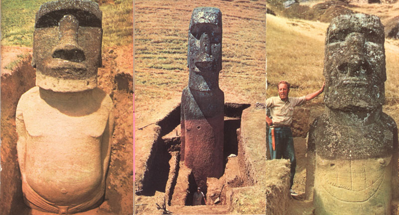
There have been many, many centuries or millenniums of silt buildup around the earliest and most finely carved of the Easter Island statues, attesting to their very great-age. The statue shown to the left portrays a very refined belt and buckler arrangement at the waist, indicating a civilisation with advanced manufacturing and artistic skills. The centre picture shows silt buildup of somewhere in the vicinity of 20 to 24-feet. Such general depositing of blown sand, subsiding gravel, clay silts and humus over a vast surrounding area would have taken an incredibly long period of time to occur. The ancient statue to the right shows a three-masted sailing vessel design on its stomach. The Phoenicians of the Mediterranean (circa 1500 BC) used huge "round ship" cargo vessels that were larger than the sailing ships used by Christopher Columbus (1492 AD) when he sailed to the New World (the Americas). Expert commentary related to the advanced shipwright skills displayed by the Phoenicians and other contemporary civilisations states that there is no technical reason why they could not have sailed to the Americas 2000-years before Columbus. The additional fact that Phoenician writing, as well as Scandinavian Rune writing, etc., has been found in Peru, as elsewhere in the Americas, or that South American substances like tobacco and cocaine were used in large quantities by the Egyptians for medicinal purposes or embalming processes, shows that there was thriving ancient trade between the continents. Photos from Aku Aku, by Thor Heyerdahl, 1957.
One exemplar of several very recognisable ancient Mediterranean scripts, found incised into New Zealand boulders ... This one was translated by Dr. Barry Fell. The fact that New Zealand is the most remote and distant habitable location from the Mediterranean and Europe shows that ancient navigators from the other end of the world could navigate to any desired clime or position on the globe. Ancient oral traditions of the Maori people of New Zealand are replete with references and descriptions of the "uru-kehu" (reddish, golden-tinged hair) and "kiri-puwhero" (reddish, light-complexion skin) stone builder people who preceded them. Learned Maori elders throughout New Zealand can still point out the many locations where the ancient Europeans lived and all aspects of Maori cultural symbolism, as well as many artefacts, arts, etc., were inherited as the spoils of conquest from these earlier people. What happened at Easter Island is, essentially, no different to what happened in New Zealand with the arrival of the Polynesian warriors and Maori oral traditions tell much the same story as the oral traditions of the learned elders of Easter Island. Unfortunately, post-modernist, paternalistic, social engineer archaeologists are obliged to discount the old stories as "unreliable", as the history expressed within them is in direct conflict with self-serving globalist-preferred fantasies and political agendas. No qualitative research is forthcoming from these very biased, UNESCO-manipulated "snake-oil-salesmen", who provide only very selective, politically expedient and approved "results".
Just seeing the huge amount of soil buildup around these ancient
statues demonstrates all-too-vividly the degree of disinformation we're being
subjected to by the "politically-aligned", experts (so-called).
People like Dr. Terry L. Hunt of the University of Hawaii, would have us believe
that Polynesians carved, transported and erected all of these statues (over
1000 of them, some weighing over 50 tons each, with separate top-knots weighing
an additional 20-tons) only fairly recently.
Apparently the Polynesians also went on to build all of the huge ahu platforms
around the coastline or the thousands of related structures scattered across
the length and breadth of the island (mounds, cairns, walls, etc.) just a
few centuries ago (between 1200 - 1700 AD). According to our experts (so-called)
all of this was done purely out of reverence for illustrious predecessors
or chiefs in the family tree, with individual statues representing granddad
or some great ancestor and culture-hero further back. What a load of socially-engineered
cogswallop!
Heyerdahl writes: It
was discovered for the first time that there were three clearly separated
epochs in Easter Island's enigmatic history. First a people of highly specialized
culture, with the typical style of South American masonry technique, had been
at work on Easter Island. Our carbon datings testified
that these earliest discoverers of the island had arrived more than a thousand
years before the ancestors of the present Polynesian population*. The
classical buildings from this earliest period had no parallel in the later
history of the island. Gigantic blocks of hard basalt were cut like cheese
and fitted carefully to one another without a crack or a hole, and these mysterious
constructions, with their elegant steep walls, stood for a long time, looking
like altar-shaped and partly stepped fortresses all around the island. But
then the second epoch had begun. Most of these early classical had been partially
pulled down and altered, a paved slope had been built up against the inland
wall and giant figures in human form had been brought from Rano Raraku and
erected with their backs to the sea on top of these rebuilt edifices, which
now often contained burial chambers.
It was while this gigantic task was at its height in the second epoch that
everything came to a sudden and unexpected standstill. A wave of war and cannibalism
swept over the island a very few generations before the Europeans arrived
under Admiral Roggeveen in 1722. When this genuine Polynesian wave arrived,
all cultural life came to an abrupt end, and the tragic third and last phase
of Easter Island's history began. No one chisled great stones now, and the
statues were pulled down without reverence. Boulders and shapeless rocks were
flung together to make funeral mounds along the walls of the ahus
and the great fallen statues were often used as impoverished roofs for new
burial vaults. The work was makeshift and utterly lacking in technical ability.
(Emphasis added).
*Footnote: What happened to the carbon dating results from Thor Heyerdahl's circa 1957 expedition? Are these scientifically determined results (a) inconvenient? (b) no longer considered to be "Politically Correct" or "Racially Sensitive", as all accomplishments at Easter Island have been "officially" given-away to the Polynesians? (c) not considered to be politically-expedient in consideration of globalist agendas for the Pacific and subsequent regional egos that need to be stroked?
For more of Heyerdahl's incisive observations about Easter Island: CLICK HERE
So, let's see how the ancient Easter Island school worked for teaching initiates advanced proficiency in navigation upon the vast open seas:
EASTER ISLAND'S ANCIENT TRIANGULATION SYSTEM, HILLTOP TO HILLTOP & TO THE OUTLYING ISLANDS
The ancient surveyors who set out the Easter Island school of navigation, first had to look very long and hard at the topography of the island to see what was exploitable in a surveying sense. All of the high points were of paramount importance, as these could be used for triangulation and very accurate mapping of the entire island. With a lot of forethought, planning and exploration, a series of markers could be set up on and around the highpoints which would give very significant coded readings to other high points further afield. Plateaus needed to be cut where incoming lines could resolve upon markers, sighting pits or depressions established where observers could look at specific targets from a fixed position, mound humps or cairn markers built, which could be seen from a long way off and, eventually, an entire triangulation complex established that crisscrossed the totality of the island with alignments. We will now reconstruct, in part, some of the major alignments of this ancient surveying complex.
In precise surveying there has to be a master "benchmark" from which all secondary positions are established and back to which all survey lines both resolve and eternally relate. The benchmark position has to be something very permanent, which will not be disturbed or eradicated. It also needs to provide a very finite point of resolution. Such a natural feature of enduring, eternal stone was the splendid pinnacle point of little Motu Iti Island, lying just offshore due south of Easter Island.
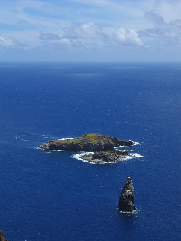
Where it all began in a surveying sense. The foreground pinnacle of rock, which from a certain angle can look very much like a carved moai statue, represents the primary benchmark for the design of the huge Easter Island, ancient surveying complex and school of navigation. It is called Motu Kau Kau. Immediately behind it is a slightly larger island called Motu Iti and yet further behind that is the largest outlying island called Motu Nui. These uninhabited rocky outcrops stand very close to the southernmost tip of Easter Island and are, today, bird sanctuaries.
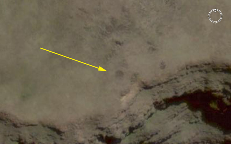
Although further verification will need to be done by on-site observation, it appears very strongly that the position shown by the arrow (a surveying pit depression?) was the beginning point for all surveying endeavors on the main island. Everything will resolve back to this point and the mark sits 7200-feet due East of the northern face of Motu Kau Kau pinnacle rock (the main benchmark for all surveying and ahu platform design layouts at Easter Island).
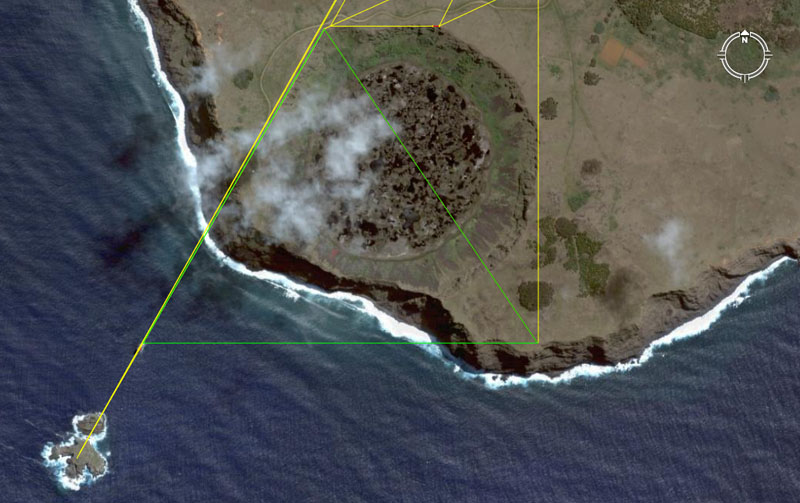
Because the ancient surveying layout for Easter Island is quite complex and involved, we don't need to concern ourselves with anything much more than the green triangle seen above to start off with. Simply stated, the yellow line starting in the middle of Motu Nui (bottom left) crosses over Motu Iti, then Motu Kau Kau then proceeds to the summit of Maunga Terevaka, the highest point of Easter Island. Both the distance(48000-feet) and angle (29.53125-degrees ... 29 & 17/32nds) of this line are coded. Let's now see some closeups of points of the triangle.
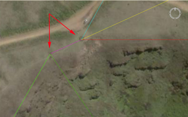
Two red arrows point to apparent ancient markers. One indicates the position of the apex of the green triangle (pyramid) and the other sits at the spot on Rano Kau volcano where tourists converge to look down into the crater or across to the outlying islands. Like so many places in modern usage, it was, without doubt, the position of a primary marker in ancient times and it acts as the hub for several very important alignments to the high points of Easter Island, which are:
1. The blue line runs for 38880-feet at an azimuth angle of 29.16-degrees to the summit of Maunga Terevaka, the highest point of the island. This distance value is highly significant under the navigational system encoded into the base dimensions of the Great Pyramid. Two circumnavigations of the Great Pyramid was 6048-feet for 1-minute of equatorial arc. Under this system the Earth was considered to be 12 X 12 X 12 X 12 X 1.2 Greek miles of 5250-feet in circumference at the equator (24883.2-miles). By this navigational method the sum of 388.8-miles would be 1/64th of the equatorial circumference. This distance at Easter Island would be 1/3360th of the circumference of the Earth.
The angle of 29.16-degrees (29 & 4/25ths) is strong lunar coding and the Roman Pace was 58.32-inches or 29.16-inches X 2. The Roman lunar foot (for measuring divisions or periods within the 3 lunar cycles) was 11.664-inches (1/5th of a Pace). The actual foot used in measuring overland distances was 11.66666-inches (simply 11 & 2/3rds). Therefore a true overland Pace was 58.33333-inches. This distance (38880-feet) at Easter Island was also 39990 Roman feet.
2 The yellow line runs for 65340-feet at an azimuth angle of 65.625-degrees (65 & 5/8ths) to a specially excavated and prepared resolving platform or plateau on Puakatike volcano at Poike, on the eastern-most end of the island. Under the Great Pyramid's second navigational system 1-minute of arc was considered to be 6050-feet instead of 6048-feet. This meant that the equatorial circumference could be measured in miles of 5280 feet (British-miles ... "11" family of numbers) instead of 5250-feet (Greek-miles ... "6&7" families of numbers combined). Under this second system the Great Pyramid was considered to be 3-inches longer (756.25-feet instead of the literal 756-feet). The equatorial circumference was read as 24750-miles of 5280-feet each under this system. This distance at Easter Island (65340-feet) equals 10.8-minutes of equatorial arc or 1/2000th of the equatorial circumference.
The azimuth angle is both lunar and navigational simultaneously and a mathematical progression based upon this value delivers up highly useful numbers. The sum of 65.625-feet would be 1/80th of a Greek mile of 5250-feet. The sum of 6.5625-days (157.5-hours) would be 1/54th of a lunar year. Dividing lunar periods up into 54ths was highly convenient mathematically. (Note: the sum of 157.5-feet would be 1/4 of a Greek Stadia measurement of 630-feet, etc).
3. The red line is a short "baseline" for surveyors. It runs for 1980-feet at an azimuth angle of 90-degrees (due east) and resolves upon what appears to be a cut plateau beside the Rano Kau volcano crater. There also appears to be a sighting put or marked position at 1866.24-feet along the line. The overall length is in homage to the equatorial width of the Earth, which was anciently considered to be 7920-miles. The sum of 1980 is 1/4th of 7920. The other marked point is in homage to the equatorial circumference of the Earth rendered in feet and 1866.24-feet would be 1/70000th of the equatorial circumference. The actual purpose of the measured line running due east-west was for triangulation calculations, based upon viewing the same outer targets from each end of the line, Knowing the length of the baseline and the differing angles to the target allowed for very accurate distance calculations, using trigonometry. The SINE values required could be in permanent record upon quippu string knot devices.
The angle is self explanatory and from the end of the baseline, other coded distance and angle vectors were sent to the various high points of the island. The baseline (270-degrees to 90-degrees) allowed for perfect degree angle readings to all other targets.
4. A short purple (magenta) line is seen running from the circle benchmark position to the apex of the triangle (green) is 126-feet long (12-Hebrew Reeds of 10.5-feet each). The angle towards Puakatike volcano at Poike (65.625-degrees) remains the same.
5. Now we can consider the two green lines that converge onto this point. The one to the left runs on a coded length and angle that perfectly dissects the little island of Motu Kau Kau, traverses Motu Iti and resolves to the centre of Motu Nui. The distance from this point to the high pinnacle of Motu Kau Kau is 6720-feet, which is a very important navigational code. A mathematical progression based upon 672 delivers up very dynamic values. The sum of 672-feet would be 1/9th of 1-minute of arc in the equatorial circumference.
The distance from the front face of Motu Kau Kau, presumably from a marked position just above the high water mark, to this apex position on Rano Kau volcano is 6600-feet (1.25 miles of 5280-feet). The azimuth angle from Motu Kau Kau is a perfect 30-degrees, for a return angle (180-degrees opposed) of 210-degrees. This meant that ancient manual theodolites or alidades and associated, calibrated degree angle disks could be set with ease, resulting in perfect readings of angles to inland targets.
The other green vector is very important also, as it establishes a cliff side position from which grid referencing of the entire island commences, in relation to the position of Motu Kau Kau Island. The line runs for 6912-feet to, what looks to have been a cairn or dark dot marker near the cliff. The azimuth angle is 145.8-degrees. The 6912-feet distance is in homage to the set of values used to describe 1-degree of arc for the equatorial circumference. Under the reading of 24883.2-miles, one degree of arc would be 69.12-miles. This distance across the crater of Rano Kau would be 1/18900th of the equatorial circumference. Note: The Great Pyramid is 756-feet in base length or 189-feet X 4.
The angle of 145.8-degrees is both navigational and lunar coding simultaneously. The sum of 14.58-inches would be 1/4th of a Roman Pace of 58.32-inches, etc.