EASTER ISLAND NORTH-SOUTH-EAST-WEST GRID ALIGNMENTS
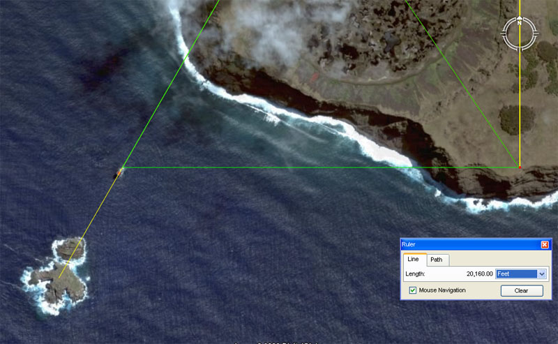
The green line running horizontally is a perfect east-west in its orientation. It appears plausible that surveyors would have established a carefully placed land-based position on terrain near the cliff-face to mark this perfect east-west fix. This factor will need to be verified on the ground at Easter Island. Once the surveying position was in place it provided a station for the next surveying station to the north. In the above picture a panel is shown that indicates a northward running line of 20160-feet. This line ends at Ahu Vai Uri platform at Hanga Roa.
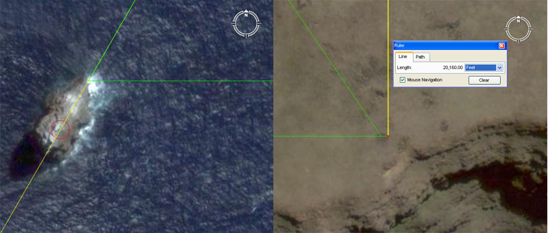
Again, we have pictures of the beginning and end points of the line running between the front face of Motu Kau Kau to the cliff station situated perfectly east. There appears to be a faint ground mark at the termination point, which also acts as a resolving position for the vector running down diagonally from Rano Kau volcano's northern rim. Although the terrain on the seaward side of Rano Kau is steep and rough in places, it appears plausible that a benchmark flat or cut would have been provided to mark this surveying position. The line between the little island of Motu Kau Kau to the dot marker on the cliff is 7200-feet long (an important navigational and astronomical use value). A yellow line is seen to start at that point and disappear off the top of the picture. We will now trace that line for 20160-feet to its northern resolving station at Ahu Vai Uri platform on the coast adjacent to Hanga Roa township.
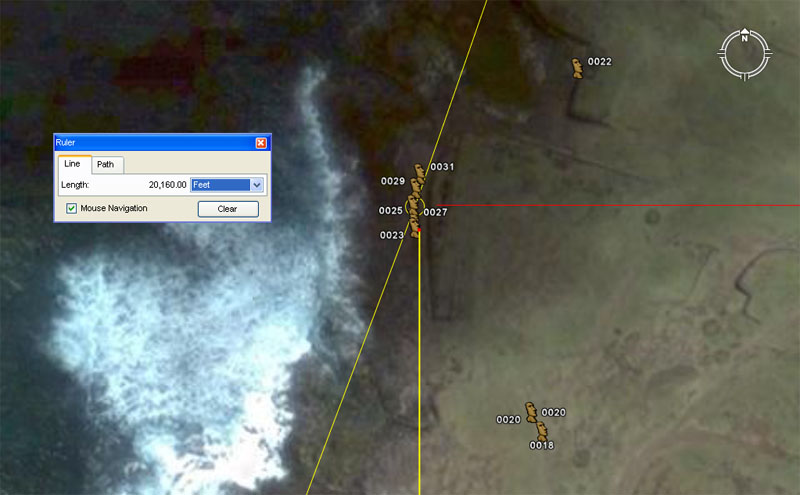
The northern end of the 20160-feet line terminates adjacent to the southernmost moai on the Ahu Vai Uri platform. There are a series of slightly differing codes associated with this number as it relates to the equatorial size of the Earth under several slightly varying systems. Let's consider these:
1. Under the literal method encoded into the dimensions of the Great Pyramid, one minute of equatorial arc was 6048 feet. This value was derived by circumnavigating the Great Pyramid twice @ 756-feet length per side (8 X 756 = 6048). The sum of 2016-feet would be 1/3rd of 1-minute of arc. Therefore, this distance marked into the terrain of Easter Island (20160-feet) equates to 3 & 1/3rd minutes of arc or 1/6480th of the equatorial circumference. Note: The value 648 is highly important to navigation or calculations to do with the duration of the Precession of the equinoxes, etc.
2. Under the Great Pyramid's second navigational system the side length was considered to be 3-inches longer or 756.25-feet. By this adjustment navigators could work in miles of 5280-feet rather than what became known as Greek miles of 5250-feet. The slightly larger mile was full divisible by "11" and any "11" based diameter will convert to a sexagesimal circumference (based upon the number 60), which makes it easy to determine correct degree angles within a 360-degree environment. It was this "window of opportunity" that allowed for precise positional plotting at sea, with a ship tacking across the vast, featureless oceans in so many "miles" this way, then turning on the wind to tack so many "miles" that way. Under the second reading the length from the cliff station was 20166.66666, as 1-minute of arc by the second reading was 6050-feet. This means that the second position was 6 & 2/3rds feet further north, which would place the termination point very close to the second moai up the line.
3. There were other closely related systems, including a shared Egyptian and Greek one that configured the equatorial circumference as 25000 Greek miles, which also equated to 5000 Egyptian Atur's of 26250 feet each. Under such circumstances, this measurement at Easter Island originating at the southern cliff-side station would be 20254 & 17/27ths feet, which would equate closely with the most northern extremity of the platform upon which the moai sit.
Apart from providing an exact fraction reading on the equatorial circumference of the Earth in accordance with the Great Pyramid's literal standard, a major function of Ahu Vai Uri was to act as a station for a due west to east alignment to a dynamic marker 7.75-miles eastwards. Here's how it worked:
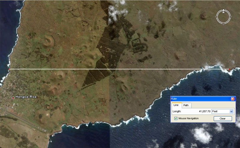
In the above picture a line is seen to run perfectly east west for 7.776-miles. The line begins at the shoreline where the sea first touches the land, then passes through the central moai of Ahu Vau Uri (the biggest one) before traversing two-thirds of the island's length to resolve perfectly upon a deeply cut dot marker in the landscape. From that eastern dot marker the line turns north again to traverse the entire width of the island and resolve onto Ahu Te Pito Kura on the northern coast.
At Ahu Vai Uri there is ancient provision of at least two coded points to produce separate readings. The distance listed in the Google panel above is meant to convey 41,057.28-feet or 7.776-miles. The ancient surveyor-navigators used the point where the sea meets the shoreline (at high or low tide) as the point of resolution for the most extreme reading. The distance of 7.776-miles would be 1/3200th of the equatorial circumference of the Earth for a world that was 24883.2-miles around.
For manual simplicity, however, the ancient surveyor-navigators established another circle dot marker slightly inland, which sat directly in front of the central and tallest moai statue of Ahu Vai Uri. This dot marker designated exactly 7.75-miles from the former dot marker sitting south of Te Pito Kura on the northern coast.
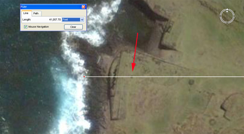
The the distance to the rock shelf where the sea meets the land is 7.776-miles to the inland dot marker due east. The distance to the marker cairn (see arrow) in front of the ahu platform is exactly 7.75-miles (40920-feet).
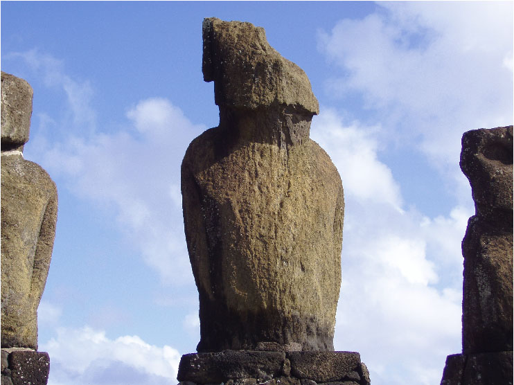
The due west to east (270-degrees) line, running from the point where the sea meets the land, passes directly through the centre moai, the tallest in the grouping of five, to resolve upon the an excavated dot marker 7.776-miles eastward. A cairn at the front of this moai marks 7.75-miles to the eastwards dot marker and the statue looks directly due east back at the point where this carefully surveyed, ancient marked alignment resolves.
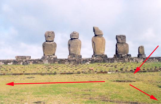
This picture shows the dot marker or former cairn sitting directly in front of the largest of five moai on Ahu Vai Uri. One arrow points to the ground marker, whereas the arrow to the left points south to the cliff, some 20160-feet away. The third arrow points due east to the excavated dot marker exactly 7.75-miles eastwards.
And here's the next surveying station:
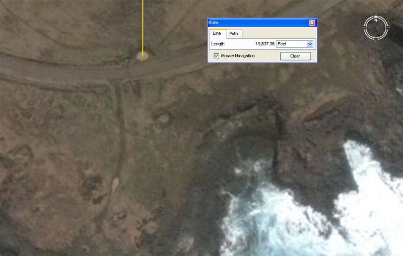
Like several thousand other sites at Easter Island, the dot marker is not mentioned in the Rapa Nui Archaeological Database as an archaeological site. It is, however, very obvious that this is an ancient surveying benchmark feature. The position relates as equally and perfectly to markers on the extremities of the west coast as it does to Te Pito Kura moai due north.
This above photo was taken from an earlier version of Google Earth, where the the sun was much brighter and there was far less cloud cover obscuring important points of the island. The earlier photo was far superior, from the standpoint of research, than what's presently available.
Now lets find out what's happening northwards:
NORTH TO AHU TE PITO KURA
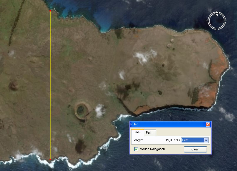
This is an earlier photo where there was no cloud obscuring Ahu Te Pito Kura on the northern coast. The line runs for just over 19800-feet to resolve upon positions behind, what was, the largest and most majestic moai statue of Easter Island.
Here's the line to moai Te Pito Kura.
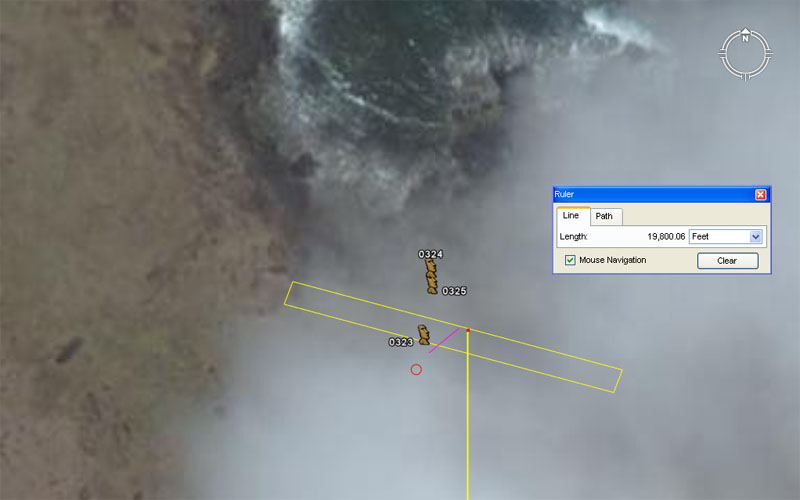
In an earlier version of Google Earth the Ahu Te Pito Kura was cloud free and the fallen giant moai visually detectable. the AutoCAD lines in the photo were then made according to what could be seen. These precise lines can now be superimposed upon the new, cloud-obscuring image. In the above photo the magenta line shows the fallen position of moai Pito Kura and the red circle designates the exact spot of the red lava stone top-knot. The line running due north from the dot marker resolves very well onto what was the standing position of the giant moai statue. The distance indicated shows clearly that the intended length sought after by the ancient surveyors for this alignment position was 19800-feet.
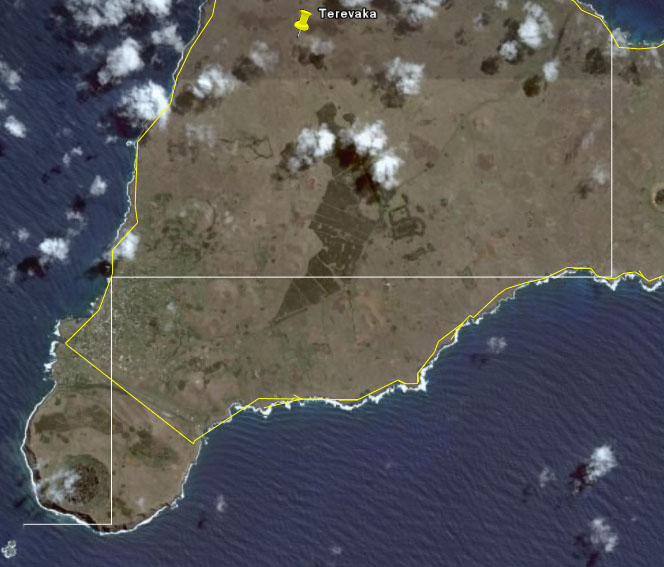
The white lines show the primary and secondary surveying
benchmarks, stepping very accurately up the island from marker to marker.
The lines run perfectly east-west or north-south. The primary benchmark or
beginning point for all other purpose built markers on Easter Island is the
very sharp pinnacle island of Motu Kau Kau and the final resolution point
of this stepped system is the largest statue on the island (Te Pito Kura on
the northern coast). Just showing the existence of this much of the original
grid is sufficient to prove the case that the ahu platforms and moai statues
were alignment markers within a very sophisticated surveying complex.
The yellow lines
shown run at very accurate and recognisable coded distances and angles from
one ahu platform to the next around the coast.
We're now at the water's edge on the northern coastline and can venture no further without getting our feet wet, so lets talk a little more deeply about the codes of this position at Ahu Te Pito Kura: