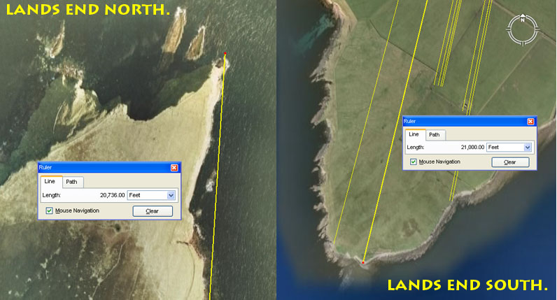
THE CODED DISTANCES & ANGLES TO LANDS-END.

A major reason why the main hub for Eday Island was carefully
positioned at London Bay was so that coded distances and angles were achievable
to "lands-end" from the central hub. For the line running NNW the
intended distance was 20736' @ 3.6-degrees.
For the line running SSW the coded distance was 21000' @ 13.75 return to London
Bay hub-mound.
1. It seems obligatory that the intended northern tip code for Eday Island was originally set to 20736', as this is a dynamic ancient value used for coding the equatorial size of the Earth. With the Earth's circumference set to 12 X 12 X 12 X 12 X 1.2 = 24883.2-miles, the division of 1/12th of the circumference (30-degrees of arc) = 2073.6-miles. Also, the inch-value of 20736' is 248832" or 12000 Egyptian Royal Cubits. Consider the following:
(a). The largest Egyptian Royal Cubit measurement found by Sir William Flinders Petrie was 20.736". By careful measurement he determined that the intended length of the coffer in the Khafre Pyramid of Egypt was 103.68" or 5 Royal Cubits of 20.736" each. It's interesting to note that the capacity of the Stirling Jug of Scotland was set to 103.68 cubic inches (3/50ths of a cubic foot). This much-used ancient value was for calculating the speed of the Earth's rotation per hour: Therefore 24883.2-miles ÷ 24-hours = 1036.8 MPH. The Stirling Jug capacity was simply the ancient Hebrew, Jerusalem Standard, liquid volume measure called a "Cab".
(b). Paving slabs at the base of the Great Pyramid measured 34.56' or 20 X 20.736" (20 X 1.728').
(c). Ancient Masters of the Craft would have been intent upon
utilising every available opportunity to teach additional, close proximity codes
that could be associated with each laboriously erected marker stone or cairn.
In addition to the 3.6-degree angle of this vector running to the northern tip
of Eday Island, it would also have been read as 3.456 (navigation), 3.5 (calendar
& navigation) & 3.54375 (lunar cycle) -degrees respectively. Also, in
a mnemonic sense, the 20736' distance would have been read as 20625' & 20618.18182,
respectively.
There were 3 marginally different Egyptian Royal Cubits and each was fashioned
to work within varied number families. The "11" family one, which
was used in measuring the equatorial circumference (with the mile of 5280')
was 20.625" in length. The one used in measuring the equatorial circumference
using the "6&7" system (with a mile of 5250') was 20.61818182"
(The result of dividing the base length of the Great Pyramid (756' or 9072")
by 440.
The northern tip of Eday, at the top of the cliff is now about 30' short of this 20736' distance, whereas the base of the cliff at the water mark would be about correct. It's plausible to assume that a marker would have once stood at the top of the cliff, but that 5000-years of wind-lashing and pounding seas in the interim period have had a significant eroding effect and loss of some of the upper landmass.
The southern tip of Eday Island, before drop-off down to the sea, complies to a coded distance of 21000' @ a return angle back to London Bay hub-mound of 13.75-degrees.
(a) This distance is 4 Greek miles of 5250' or 1 Irish league.
(b) The angle of 13.75-degrees is navigational coding and the sum of 1375' would equate to 1/12th of an English league of 16500'. By consequence, distance of 1375' would equate to 800 Egyptian Royal Cubits of 20.625" (the interim or middle Egyptian Royal Cubit of the 3 known types).
NOUP HILL ENCLOSURE, DYKE & MISCELLANEOUS STRUCTURES.
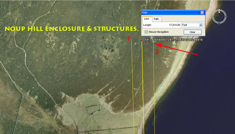
The NE summit region of Noup Hill shows evidence of an ancient enclosure settlement, including a straight-wall (dyke) composed of massive sandstone boulders. The general region sits 17010' from the London Bay hub-mound and this is strong lunar coding. The sum of 1701-days would be 1/4th of the duration of the 6804-day lunar nutation cycle. The site is bracketed by two coded degree angles. The first of these is 358.4-degrees from London Bay. The second is 179.2, return to London Bay.
1. The 358.4-degree angle value generates a mathematical progression used in navigation and for calculating the equatorial circumference of the Earth.
2. The 179.2-degree angle value generates the same mathematical progression, but at half value increases. 358.4 ÷ 2 = 179.2.
CARRICK CHAMBERED CAIRNS
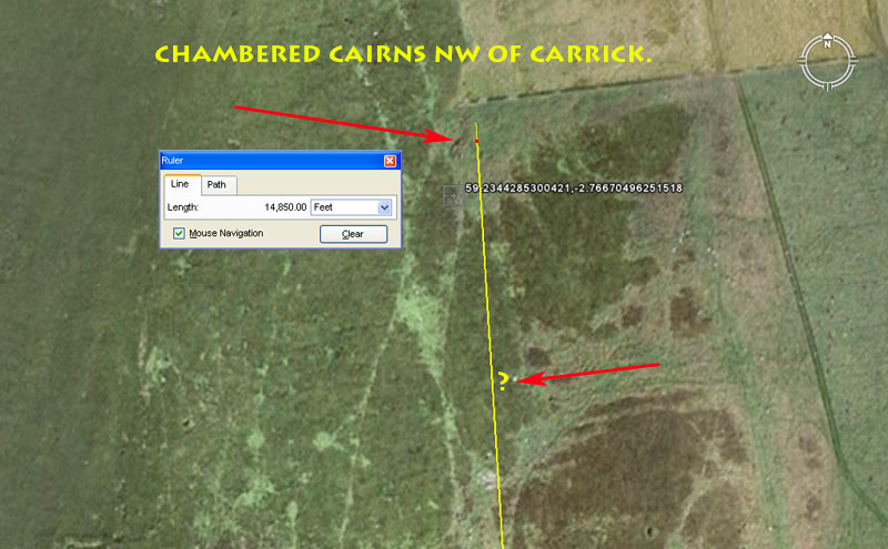
Two chambered cairns sit on an alignment that originates at London Bay hub-mound. The angle of the alignment is 356.4-degrees (navigational). The first cairn out probably sits at a coded distance of 14580' (3 Roman miles of 4860' each ). There appears to be contradiction between the RCAHMS coordinates and what is shown on the map. The Google Earth image is not sufficiently clear to positively identify the position of that particular structure. The other chambered cairn sits 14850' out (2.5 Scottish miles of 5940' each).
WITHEBEIR HORNED, CHAMBERED CAIRN.
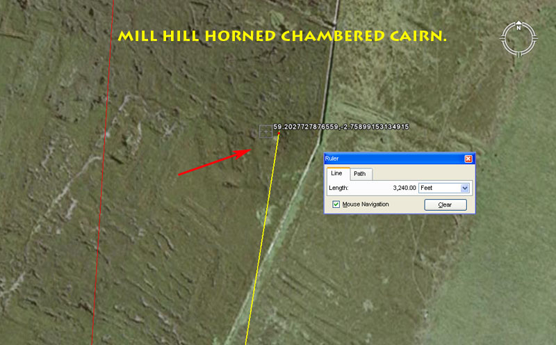
At the top of Mill Hill is a substantial, horned chambered cairn that was excavated in 1855. It has a diameter of up to 65' and four compartments. The structure is now almost completely obscured by heather overgrowth. It has what remains of a horned courtyard or assembly area on its East side.
The chambered cairn sits 3240' from London Bay hub-mound @ 9-degrees. A mathematical progression based upon 324 generates many very important navigational and cyclic astronomy numbers, as well as essential values used for calculations related to the Precession of the Equinoxes.
The angle, @ 9-degrees, is 1/40th of 360-degrees.
Another light coloured position seen poking through the heather to the cairn's South might be worthy of investigation, as it sits within the limits of 3110.4' from Bay of London hub-mound, and on the same dissecting angle as the horned cairn. The 31104 value is dynamic and found to be copiously encoded into positions within the ancient open-air universities. The sum of 3110.4-miles = 1/8th of the 24883.2-mile equatorial circumference.
A red line is seen to bypass the chambered cairn on the western side. That line runs for 20736' @ 3.6-degrees to the most northern tip of Eday Island. Nearby the chambered cairn, but on that red line, 2520' out from London Bay hub-mound (RCAHMS coordinates), is yet another ancient site. It is composed of a line of standing boulders and is classified as a dyke. The sum of 2520' would equate to 2400 Greek feet of 12.6" each or 1200 Assyrian Cubits of 25.2" each. It would also be 240 Hebrew reeds of 10.5' each, as well as 300-seconds of equatorial arc @ 100.8' per second of arc.
STENNIE HILL CARVED STONE.
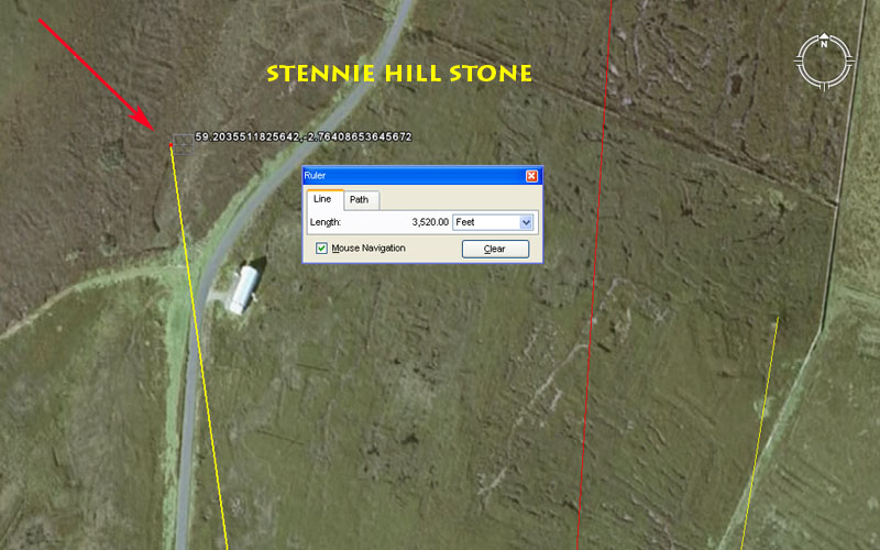
To the WNW of the Mill Hill horned chamber cairn a carved stone was located on the eastern side of Stennie Hill. It sat 3520' out from London Bay hub-mound @ 352-degrees.
The sum of 3520' is 2/3rds of a 5280' mile. The angle is, of course, an expression of the same mathematical progression and coding.
BAY OF DOOMY BURNT MOUND.
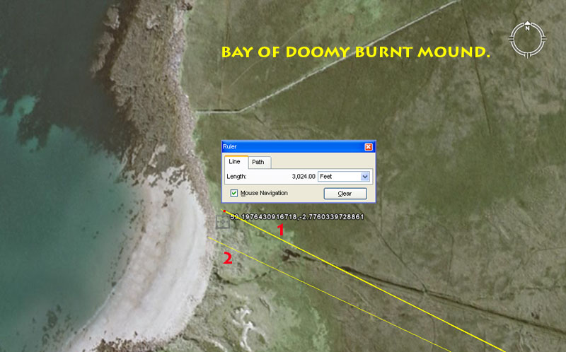
Almost directly across the centre zone of Eday Island from London Bay on the East coast is Bay of Doomy on the West coast. Extending southwards from this point are several ancient markers that were purpose-built to be at very significant distance and angle codes away from the hub-mound. The Doomy Bay mound is right on the beachfront and is bracketed by two coded vectors.
1. A line runs from the centre of the London Bay hub-mound for 3024' @ a return angle of 116.64-degrees. The Great Pyramid of Egypt is 756' long per side or 3024' for one complete circumnavigation. This distance is 1/2 of 1-minute of equatorial arc in the circumference of the world. The sum of 11.664" was the length of a Roman foot and this value sets up a dynamic mathematical progression much-used in navigation or in "volume standards" or the ancient world.
2. The line is, once again 3024' and the angle is 295.3125-degrees. This degree angle is one of the most important and most encoded on the ancient open-air university sites. The lunar month is 29.53125-days (2917/25ths) to a tolerance of less than one minute.
It's significant that many of Eday's "burnt mounds" are distributed around the coastline and would have acted as coastal beacons to either ships at sea or from vantage points on surrounding islands (as well as Eday itself). Many theories have been put forward to explain the purpose of "burnt mounds", including that they were places for cooking food. None of these explanations are satisfactory, however, especially in view of the fact that its rare to find any bones or residues related to feasting. The burnt mounds were simply humps, sometimes with carefully built hearths, where fires were lit.
One explanation, from a surveyor's point of view, is that they were used as beacons to provide a pin-point of light for periodic angle fixes from afar at night. Such a function would certainly have served the vast, open-air, school of navigation very well, with student-navigator observers honing their skills in celestial navigation. The distant beacon would indicate a known land location, against a background of stars and the students could observe how a finite spot on land (a theoretical destination at a known angle) compared to the ever-changing array of stars overhead, ascending, descending or alighting in the vicinity of the beacon ... also, which horizon stars followed in the wake of others that had risen before them and how they were displaced either to the left or right. As well as the foregoing , it was essential to know how much the background stars, out to a particular degree angle of the horizon, shifted as the season changed and the Earth moved in its orbit around the Sun. This information would be essential for any night voyages, where one had to tack towards a certain point of the horizon and maintain that heading, with only the star map as a guide.
It would be a simple matter for tutors at the open-air-university to pre-arrange that a fire be lit at one distant mound or another on certain clear nights, as an aid in teaching principles of celestial navigation. In the case of Doomy Bay with its fine landing beach, the nocturnal mound fires would have been used to guide students, involved in night-sailing tutorials, to a safe haven.
DOOMY ANCIENT SETTLEMENT.
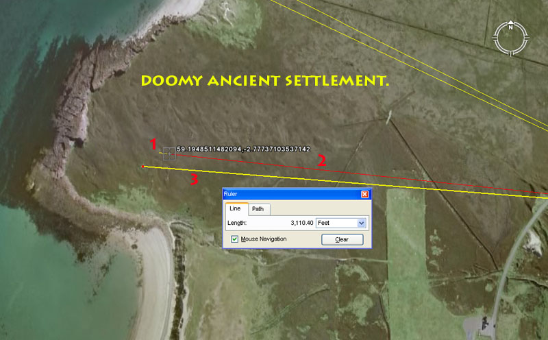
Slightly further South, archaeologists have noted the positions of several structures at Doomy, including two chambered cairns, two round mounds, drystone walls and a sub-peat dyke. This location, situated only about half a mile between sandy beaches on opposite coastlines, appears to have been the preferred rendezvous centre for incoming students from Mainland and elsewhere.
1. This is a chambered cairn in a very dilapidated state. It sits 3024' from the centre of London Bay hub-mound @ 96-degrees return.
2. Another structure sits behind the first @ 2953.125' (lunar month coding) and 96-degrees return to London Bay hub-mound.
3. This is either a Bronze Age house or a chambered cairn. It sits 3110.4' from London Bay hub-mound at a return azimuth angle of 94.5-degrees. As stated, the sum of 3110.4-miles equates to 1/8th of the 24883.2-mile equatorial circumference.
MUSSETTER SHORT-HORNED CHAMBERED CAIRN.
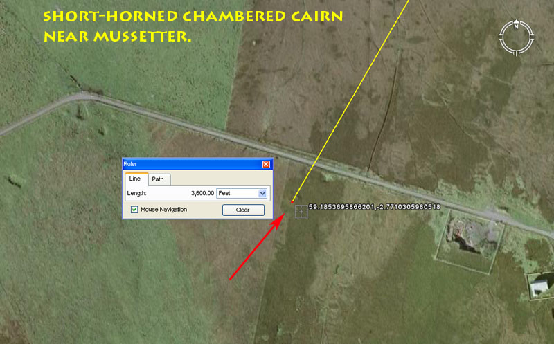
This cairn has a diameter of about 50' and is described as a "short-horned chambered cairn". The horns extend out from the structure for about 23' on the SW, SE & NE sides, with the NW horn now obliterated by latter-era excavations & disturbances. The internal chamber is about 15' long, with stalls at the sides. This chambered cairn sits 3600' (compass) from the Bay of London hub-mound @ 210-degrees (navigation, calendar), for a return angle of 30-degrees (1/12th of 360-degrees).
SANDHILL CHAMBERED CAIRN AND STANDING STONE.
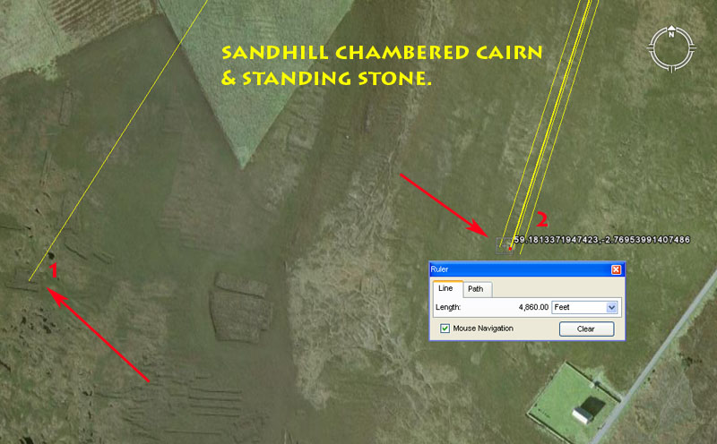
Near Sandhill (Sandyhill-Smithy) are these two sites, a standing stone and a chambered cairn.
1. Although the standing stone can't be visually detected in the Google Earth image, the RCAHMS coordinates would place it at this position shown. It seems to comply to a distance of 5600' (lunar, calendar, navigational ...the sum of 560' would be1/12th of an Irish mile of 6720') out from Bay of London hub-mound @ a return angle of 32.4-degrees.
2. The chambered cairn can be seen quite clearly. It was originally almost 27' across and was described as tripartite (made up of 3-chambers). It sits 4860' from London Bay hub-mound. It is bracketed by two dynamic, coded angles, the first of which is 198-degrees (diameter of the Earth coding). The other one is a return angle back to London Bay mound of 17.71875-degrees (lunar year mathematical progression). Two additional coded vectors fall on the mound, with return angles of 17.5 & 17.6-degrees (both related to navigation and the 5280' mile) respectively.
SANDHILL BURNT MOUND.
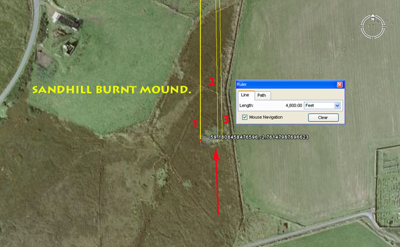
This structure is a burnt mound near Skaill. It sits 4800' from the London Bay hub-mound and is bracketed by two coded angles, with a third falling on the mound. The first of these is a perfect North-South running past the western edge of the mound. Another vector runs to the eastern side and, at 179-degrees, is 1-degree off true North-South. A third vector of 179.2-degrees (navigational coding) falls on the mound.
CHURCH CHAMBERED CAIRN, AS WELL AS A CHAMBERED MOUND OR CAIRN NEARBY.
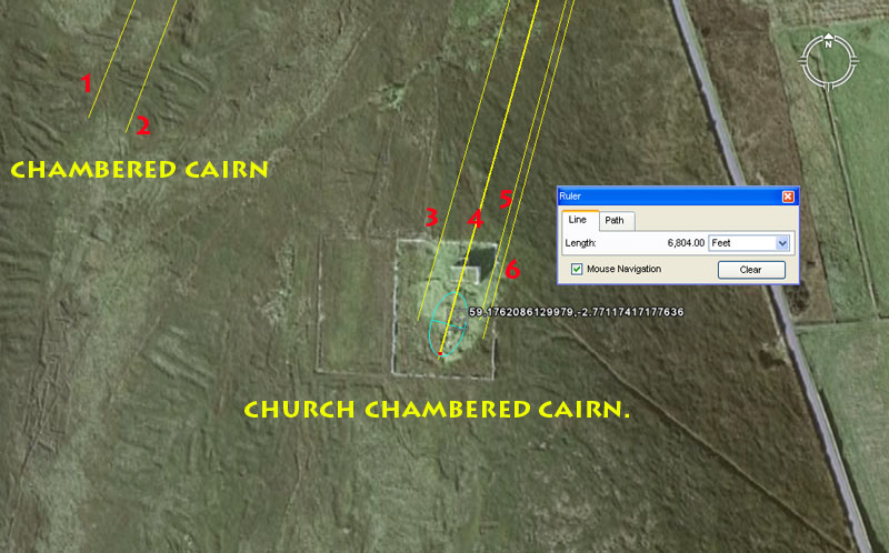
To the left is seen a chambered cairn or mound and, although the structure can't be positively identified in the Google Earth image the RCAHMS coordinates position it at about this location. It is probable that the chambered cairn or mound was intended to carry a coded length of 6600' (10 furlongs) out from London Bay hub-mound, bracketed between (1) an angle of 201.6-degrees (navigation ... the sum of 2016' would be 1/3rd of 1-minute of the Earth's equatorial arc) to its western side and (2) another of 21-degrees return on the eastern side (navigation, calendar).
To the right is seen the site of Church chambered cairn. This was a very substantial structure, which remained virtually intact for about 5000-years until 1831, when the United Presbyterian Church decided to build a church beside it. The large cairn was dug up and plundered for its stone, which was used to build the church, The RCAHMS record states:
The wreckage was investigated by Major Hebden, who found 'a
long passage or room flagged over', and numerous passages branching out and
leading to small semi-circular cells'.
The article further states: This cairn survives as an elongated quarried
pile of debris oriented NNE-SSW and measuring about 35.0m in length by 18.0m
maximum width, with several loose slabs within it.
Using the dimensions supplied, an AutoCAD generated oval is used in the above picture to overlay the position of the former cairn. It's position complies to the following coded lengths and angles:
3. A bracketing vector to the West runs for 6750' (navigation) @ a return angle of 16-degrees (important multi-use mathematical progression).
4. The overall length to the southern end of the cairn appears to have been coded to represent 6804' (lunar nutation cycle) @ a return angle of 15.552-degrees (equatorial circumference of the Earth coding).
5. Another bracketing vector to the East could be read as 6720' (Irish mile) @ 15.12-degrees (navigation ... 2 side measures of the Great Pyramid is 1512').
6. Yet another close-proximity bracketing vector could be read as 15-degrees return (important multi-use mathematical progression).
SMALL CAIRNS, STONE-LINES, MOUNDS, HUMMOCKS, PROTRUDING STONES & ENCLOSURES.
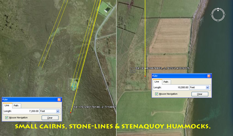
Near Church Chambered Cairn is an area composed of small cairns, tombs (?) or walls, some of which are circular, straight walls (dykes) and six mounds. The general area is 7200' from London Bay hub-mound @ a return angle of 15-degrees.
Again, at Stenaquoy are more of these small mounds (hummocks), as well as protruding stone markers and a small enclosure. This area sits 10500' due South (360-180-degrees) from London Bay hub-mound.
It's highly likely that these two sites were open-air classrooms, where particular navigational tutorials were given in and around the many carefully placed markers. Both sites are situated at significant coded distances and angles out from London Bay hub-mound, with the Stenaquoy site sitting at exactly 2-Greek miles (10500') or, with the addition 60', 2-English miles (10560') out from Eday Island's main hub. One would be hard-pressed to find any other plausible explanation as to why these sites were laboriously constructed, other than to act as navigational markers for teaching distances and angles within and around a maze of landscape structures.