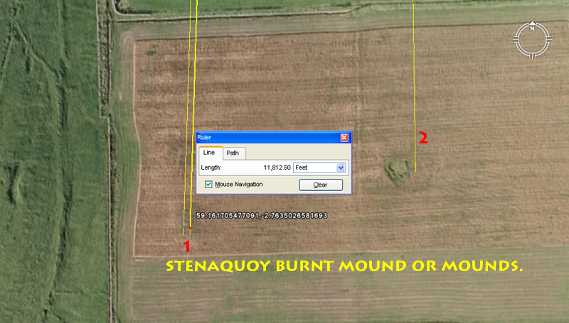
STENAQUOY BURNT MOUND OR MOUNDS.
In this SW corner of this farm field at Stenaquoy are the very faint remains of a severely plowed over burnt mound, the victim of what the Brit's refer to as "tillage". It's existence has been recognised and reported in the RCAHMS register of archaeological sites. To its ENE is another site that is marked on the archaeological map as a burnt mound as well.
1. The Stenaquoy burnt mound sits 11812.5' (strong lunar coding ... 4 lunar months is 118.125-days) from the London Bay hub-mound @ a return angle of 1.728-degrees (navigational coding). This angle can also be read as 1.8-degrees (navigational coding).
2. The site to the ENE sits 11664'* (2.4 Roman miles) from London
Bay hub-mound @ 179.2-degrees (navigational coding related to the Earth's equatorial
circumference).
*Note: The Roman foot was 11.664" and their "pace" was 58.32"
or 5 Roman feet.
The code of position for the Stenaquoy burnt mound in the SW corner is dynamic and has a direct relationship to the lunar coding built into the dimensions of the Khafre Pyramid of Egypt. The pyramid was built as two, face-to-face 3,4,5 triangles, based upon the number of days in a lunar year.
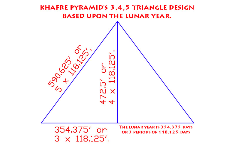
The Khafre Pyramid of the Giza Plateau was built according to a 3,4,5 triangle, as used by carpenters and other tradesmen for "squaring" the foundations of buildings prior to construction or multiple other applications since time immemorial. Because Khafre Pyramid was Egypt's pyramid of the Moon, the lunar cycle codes were built into its dimensions. Because of its direct relationship to the lunar cycles, the 118125 value is copiously encoded into the the open-air-universities of antiquity and the sum of 118.125-days would be 4 lunar months of 29.53125-days (2917/25ths).
FERS NESS PREHISTORIC BUILDING ... CHAMBERED CAIRN OR HOUSE?
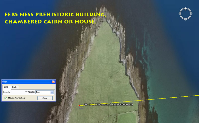
We'll now move across Eday Island and deal with some sites on the West coast. Here at Fers Ness peninsula, archaeologists have logged positive evidence of a prehistoric structure. "Two large, long slabs and four others bordering a nearly square hollow" infers that another souterrain dwelling, chambered cairn or the like was once built here. The spot identified in the RCAHMS record is certainly very significant, as it is 12000' from the centre of London Bay hub-mound @ a return angle that would be read as the coded value 85.05-degrees (strong lunar coding).
With the lunar nutation cycle enduring for 6804-days, the half period is 3402-days, the quarter period is 1701-days and the bi-quarterly period is 850.5-days.
FERSNESS BURNT MOUND.
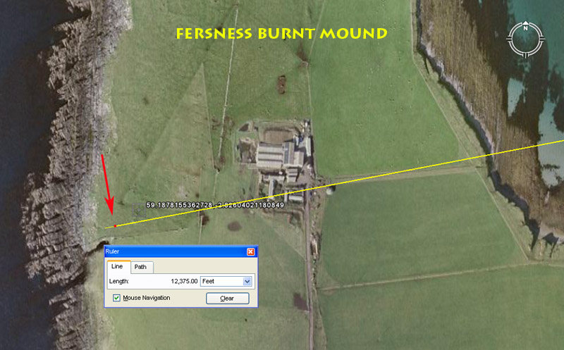
At the base of the Fers Ness peninsula is a burnt mound that is visually detectable within the Google Earth image. It contains dynamic codes of distance and angle that relate to the equatorial circumference of the Earth under two navigational systems, as well as the diameter of the Earth. Another of its coded attributes relates to the duration of the Precession of the Equinoxes.
A line extends for 12750' from London Bay hub-mound @ a return angle of 79.2-degrees and resolves upon the Fersness Burnt Mound. Under the "11" navigational system (using a mile of 5280'), 1-minute of Earth equatorial arc was 6050', a degree of arc was 68.75-miles and the equatorial circumference was 24750-miles. The half value was, therefore, 12750-miles and this distance at Eday Island is a scaled representation of half the world's circumference at a ratio of 1' = 1 English mile.
The Earth's diameter is 7920-miles and this value (in diminished form) is expressed in the degree angle (79.2-degrees). Under the "11" system the Earth's diameter was expressed as 3.125 less than its circumference. Therefore, 24750 ÷ 3.125 = 7920.
The line running to the centre of the mound can be extended to its westernmost edge and this increases the distance to a coded 12441.6'. Under the "6&7" method of navigation, using the Greek mile of 5250', the Earth was configured mathematically to represent 12 X 12 X 12 X 12 X 1.2 Greek miles of circumference = 24883,2-miles. Under this system 6048' (two full circumnavigations of the Great Pyramid @ 756' per side) was 1-minute of arc, whereas 1-degree of arc was 69.12 Greek miles. The half value of the Earth's circumference was 12441.6 Greek miles and this distance at Eday Island, extending out to the western edge of Fersness Burnt Mound is scaling the Earth circumference at the rate of 1' = 1 Greek mile.
Under this numerical system, the form of PI used to describe the diameter of the Earth as opposed to its circumference was 1728/550ths. Therefore 24883.2 ÷ 1728/550ths = 7920.
The outrunning angle to this site is 259.2-degrees and this is dynamic coding used (in inflated form) to describe the Precession of the Equinoxes. Under the factorable system devised by ancient astronomer-mathematicians to describe the precessional cycle it was considered that precession occurred at a rate of 1-degree each 72-years. Therefore 72-years X 360-degrees = 25920-years.
FERSNESS EMBANKMENT & HORSESHOE-SHAPED BURNT MOUND.
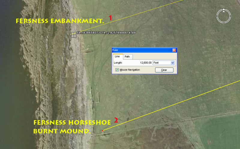
Still further down the West coast are these two closely related sites, both carrying the same distance code of 12600' (2.4 Greek miles). The first site is made up of a span of wide, low foundation embankment that is thought to have carried a a short strip of dyke wall (now plundered for its stone and gone, but with the bank remaining). The second site is a large, horseshoe-shaped, burnt mound, 35' in diameter and 4' 6' high.
1. The short length of former dyke wall was strategically positioned to act as the demarcation limit for a 12600' vector running from London Bay hub- mound @ a return angle of 72.9-degrees (lunar code). This distance would equate to 12000 Greek feet of 12.6" each or 1200 Hebrew reeds.
The 729 value was used in mathematical progressions that tracked the cycle of the Moon and there would be 91/3rd intervals of 729-days in the 6804-day lunar nutation cycle or 35-intervals of 72.9-days in the 2551.5-day lunar period tracked within the Sabbatical Calendar.The length of 7.29" was 1/8th of a Roman Pace (58.32"). It was also the design length of the Bush Barrow Lozenge artefact recovered near Stonehenge.
2. The burnt mound further to the South lies on an angle of 250-degrees for a return angle back to London Bay of 70-degrees. Another close-proximity code that would have been included in tutorials at this site is 70.4 and the horseshoe shape of the mound was probably meant to represent horns.
FERSNESS SOUTH BURNT MOUND & WARREN HALL BURNT MOUND.
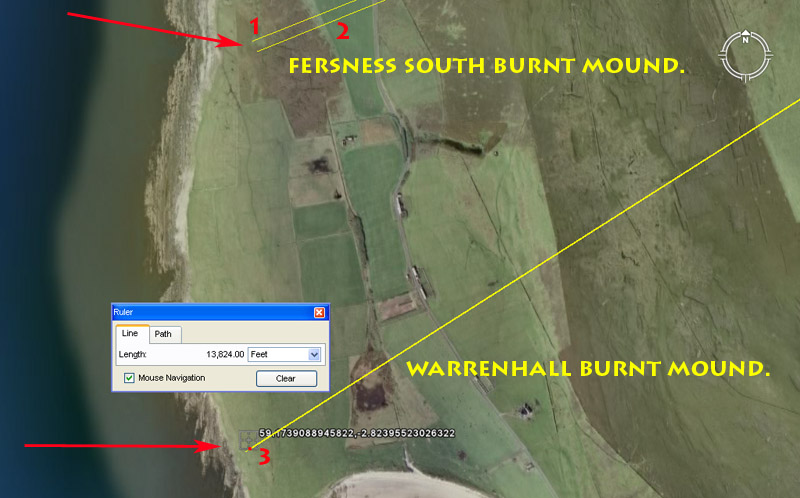
2. Yet further down the West coast is an oval-shaped burnt mound with stone content, at Fersness South. It sits a coded distance of 12500' from London Bay hub-mound and is bracketed by two coded degree angles. These are 68.4-degrees (navigation) & 68.04 (lunar) return, respectively, to London Bay.
3. At Warrenhall are the scant remains of a burnt mound that was largely removed and eradicated many years prior to 1928. It was visited by officials in 1928 who logged its existence and position for posterity. It sits a dynamic 13824' (equatorial circumference coding) from London Bay hub-mound at a return angle of 57.6-degrees (navigation).
In the 24883.2-mile equatorial circumference of the Earth, the sum of 1382.4-miles would equate to 1/18th part or 20-degrees of arc.
The angle at 57.6-degrees is dynamic navigational coding and, in a mathematical progression, the value 576 generates many multi-use numbers. For example, the 25920-year duration of the Precession of the Equinoxes is 576-years X 45; there would be 57.6 intervals of 4-lunar months in the 6804-day lunar nutation cycle, etc.
SEALSKERRY POINT MOUNDS AND STRUCTURES.
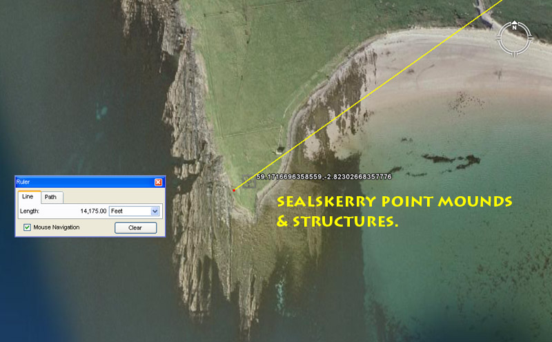
There appears to have been considerable ancient activity around the point at Sealskerry Bay, with the faint remnants of several diverse structures recorded there. A line from London Bay hub-mound is seen to traverse the position of "an amorphous mound with its centre disturbed showing a stoney content", logged by archaeologists. The line is seen to proceed further West to the approximate position where there are traces of dry-stone walling, as well as middens.
The distance and angle to the mound is 14080' or 22/3rds miles of 5280' @ 2342/3rds-degrees. Both distance and angle are, essentially, values within the same mathematical progression related to navigation by the English mile.
The more extended area westwards complies to a distance of 14175' and this is a dynamic lunar code. The Khafre Pyramid of Egypt has a design base length of 708.75' or 1417.5' for two side lengths. A mathematical progression incorporating this value will generate the essential numbers for describing the main lunar cycles. It would be unsurprising to find that yet another mound or marker stone existed adjacent at the extreme point of Sealskerry that was 14175' from London Bay hub-mound @ a return angle of 54.432-degrees.
THE GREENTOFT STANDING STONE.
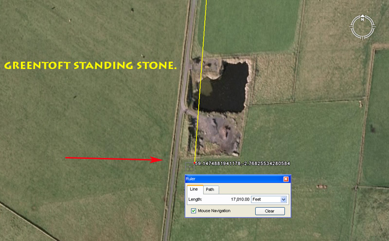
A near-tragedy was averted after a tenant farmer at Eday (some years before 1928) pulled down a standing stone on the farm, with the intention of breaking it up. Thankfully, the landlord was alerted just in time to save the majority of the stone and insisted that it be placed back into its ancient socket, thereby restoring its long-enduring codes of position. The brutalised stone now stands bloodied but unbowed and remains an eternal sentinel, guarding and preserving the following scientific information:
The distance from London Bay hub-mound to the stone is 17010' @ a return angle intended to represent 4.1475-degrees (459/400ths ... very close to 43/20ths).
KNOLL OF MERRIGARTH BURNT MOUND.
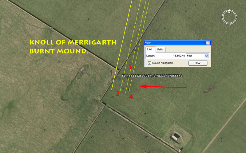
This burnt mound carries a very significant distance code related to the equatorial circumference of the Earth, as well as a series of bracketing angle tutorials.
The distance @ 18662.4' would be 1/7000th of the equatorial circumference of the Earth under the 24883.2-Greek mile assignment. Alternatively, a distance of 186684/7ths feet (about another 6') would be 1/7000th of the 24750-mile (of 5280') circumference.
The coded return angles that would have been discussed in tutorials relative to this mound would, undoubtedly, have been:
1. 12.4416-degrees (related to the equatorial circumference of the Earth).
2. 12.5-degrees (navigation, lunar, compass).
3. 12.6-degrees (navigation by the Greek mile, lunar).
4. 12.7575-degrees (lunar period within the Sabbatical calendar ... The lunar count within the Sabbatical Calendar extended through 2551.5-days or 7.2 lunar years, the half value of which is 1275.75-days).
GREENTOFT BURNT MOUND.
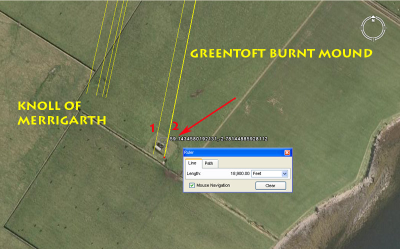
East of the Knoll of Merrigarth are the faint remains of another burnt mound that has been severely obscured by "tillage", but for which sufficient evidence is still visible to establish its existence. Again, like its counterpart to the West, it contains dynamic codes of distance and angle.
The distance from London Bay hub-mound is 18900' and this distance is 3.125 minutes of equatorial arc for a world configured to 24883.2 Greek miles of circumference. This distance would be 1/6912nd of the equatorial circumference. By the addition of 6.25' the distance would be of the 24750-mile circumference.
The 1890 value was very important to ancient lunar, as well as navigational calculations. On the Calendar of Coligny brass plaque artefact discovered in France the count of days runs to 1890. There are either 64 lunar months or 63 solar months being monitored together (128 panels of 2-week periods each). For the solar count the method is 63 X 30-days = 1890-days. For the lunar count the method is 64 X 29.53125-days = 1890-days.
The Great Pyramid @ 756' of length is 189' X 4.
The angle of 11.34-degrees is both strong lunar coding and navigational coding simultaneously. There would be 6 periods of 1134-days in the 6804-day lunar nutation cycle. There would be 22.5 occurrences of 113.4-days in the 2551.5-day lunar period monitored within the Sabbatical Calendar. Ancient Greek historian, Herodotus, was told by Egyptian priests that the Great Pyramid was 800' long. The "foot" that they were referring to was 11.34" and by using it, lunar calculations could be made around the base of the pyramid.
The other bracketing vector is 11.52-degrees return to London Bay hub-mound and this is a dynamic navigational code. The sum of 11.52-miles would be 1/2160th of the 24883.2 equatorial circumference. Also 11520' X 11340' = 24883.2 Greek miles.
WAR NESS BURNT MOUND.
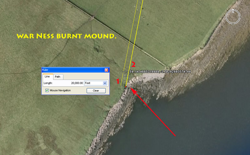
This burnt mound sits 20,000' from Bay of London hub-mound and is bracketed by return angles of 11.25 (compass) & 11.34-degrees (lunar) respectively.
THE WESTRAY WIFE MAP OF THE ORKNEY ISLANDS
One day in about 2500 BC a resident of, or visitor to, the Orkney Island of Westray dropped, mislaid, deposited or otherwise became separated from, a valued and carefully fabricated object, which was relocated during an archaeological dig in 2009. This tiny artefact, seemingly, has a great deal to tell us about surveying and navigational activities going on in the area during the late Megalithic - early Neolithic Age.
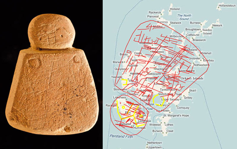
To the left is seen the Westray Wife artefact (also known as the Orkney Venus). The object has been officially measured as 41mm high (rounded to the nearest mm), which equates to 1 PHI inch (1" X 1.618034) to a tolerance of about 1/250th of an inch. When the artefact is overlaid on a map of the Orkney Islands, it very fairly represents the general, encompassing configuration of the main island group. The large chevron eyebrows seem representative of the the southwestern coastal limits of majestic Hoy Island with its two high hills. The neck trough between the head and body of the artefact works well to show the Bring Deeps channel, extending from Hoy Sound into Scapa Flow. The larger breast on the artefact seems to indicate the wider expanse of protected anchorage of Scapa Flow, whereas the smaller breast complies with Stromness, a preferred living location within the island group. The sweep of the skirt hem takes in the islands of Westray around to Stronsay and this simple, mnemonic stylisation to describe the island cluster works very well. No reasonable attempt has been made by our archaeologists to explain the many incised strokes covering the front, sides and back of the artefact, which seem very indicative of track ways too and fro across the island landmasses, or maritime entry routes into and out of the multiple channels and harbours.
A further indication that the head of the Westray Wife
probably relates directly to Hoy Island is seen in this picture of Hoy's two
majestic hills separated by a deep central trough that forms a "V"
in the landscape. The "V" was a very important surveying fix point
or benchmark for Ring o' Brodgar, as well as the Stenness Circle, Watch Stone
and Maeshowe chambered mound or other satellite structures nearby.
The ancient positioning of Ring o' Brodgar was absolutely tied to the "V"
between Ward Hill and Cuilags Hill of Hoy Island, as that was the precise spot
where the Sun alighted at sunset on the day of the Winter Solstice, as viewed
from Ring o' Brodgar's centre. By taking an annual or periodic fix on this event
in clear weather, ancient astronomer-surveyors at Ring o' Brodgar could keep
their calendar running true, right down to the day, and all planting, harvesting
or commencement of trans-Atlantic voyages could be undertaken on the optimum
dates.
The foregoing provides us with a glimpse of what was happening at the Orkney Islands around 3000 BC and later, related to the building of a huge open-air-university for training navigators. Due to the entrenched, limited and very obsolete views of our so-called experts, our modern-day students are cajoled, intimidated (you're not going to get that degree unless your get into step) or indoctrinated into accepting that our distant forebears were little better than overly superstitious, uneducated, semi-civilised sub-humans with an unhealthy veneration for dead people.
Our experts would not be able (or allowed) to conceive of the fact that our distant European forebears would have been capable of working out these mathematical principles ... let alone applying them to such things as cyclic astronomy or the equatorial size of the Earth, etc. The notion that our European ancestors could navigate across vast tracts of ocean on exploratory missions or set up thriving colonies abroad, is so contrary to "political correctness" or "racial sensitivity" requirements that it is an "unmentionable" in academic circles. Ancient Europeans are not allowed to be found outside of the confines of Europe, lest it impinge upon the pride of other "indigenous groups" or throw into question just who it was, exactly, who established the first great civilisations and highly-engineered structures in those (now) foreign realms, separated by continents and oceans.
Instead of our archaeologists dealing with the all-too-conspicuous evidence to the contrary, we continue to be bludgeoned into accepting that our European forebears had no developed systems of Weights, Measures and Volumes, despite the fact that it's well known that they did, along with their very intricate knowledge of geometry and mathematics generally. On the one hand, our experts can easily detect the very refined lengths and angles built into ancient edifices, but they still attempt to convince us that it was all done according to the length between the tip of the fingers to the elbow or the width of someone's hand or thumb, etc.
Many ancient capacity jars have been retrieved from shipwrecks,
burial mounds & caves or wells, etc., which show the wide, repetitive useage
of the same national standards for cubic capacities or exact, lesser divisions
thereof. These many varied cubic capacity vessels, found in the standards of
cousin European nations, demonstrate the use of code-bearing, highly factorable
numbers (in cubic inches) to describe the volume. Moreover, each volume vessel
was a repository of mathematically encoded scientific information, related to
the cycle of the Moon or the circumference of the Earth, etc, and the fact that
the numbers were continuously accessible in everyday life meant that the knowledge
could never be lost ...
...which explains why the Scots, after they fill the Stirling jug with appropriate
liquid refreshment, can sit there and pontificate about how the 103.68 cubic
inches therein represents 1036.8 MPH or the speed at which the 12 X 12 X 12
X 12 X 1.2-mile circumference Earth spins per hour ... but of course one must
refill the jug 10-times (for scientific purposes) before the sought after value
is achieved ...
It can also be clearly demonstrated that the "capacity volumes" of one ancient cousin nation were in direct, easy to calculate ratio with the standards of other cousin nations. The same holds true for weights standards (measured in grains), as well as lengths and this "standardisation", coupled with always coding scientific information into the standard, prevails across continents or wherever ancient Caucasoid peoples set up civilisations.
A surveyor can extract the deliberately-inbuilt codes of position placed into mound or cairn structures and standing stones across the totality of the Orkney Islands.
If our archaeologists wish to cleave to the notion that their "Ork" ancestors spent the majority their lives working for the "dead" or were sauntering around solemnly playing endless funeral dirges, then that's their prerogative. For the rest of us, our "Ork" ancestors were running a very advanced open-air-university that churned out generation-after-generation of very adept navigators, who conducted our ships and their crews to the very ends of the Earth and home again safely.
To be continued.
Martin Doutré, May 14th, 2011. ©