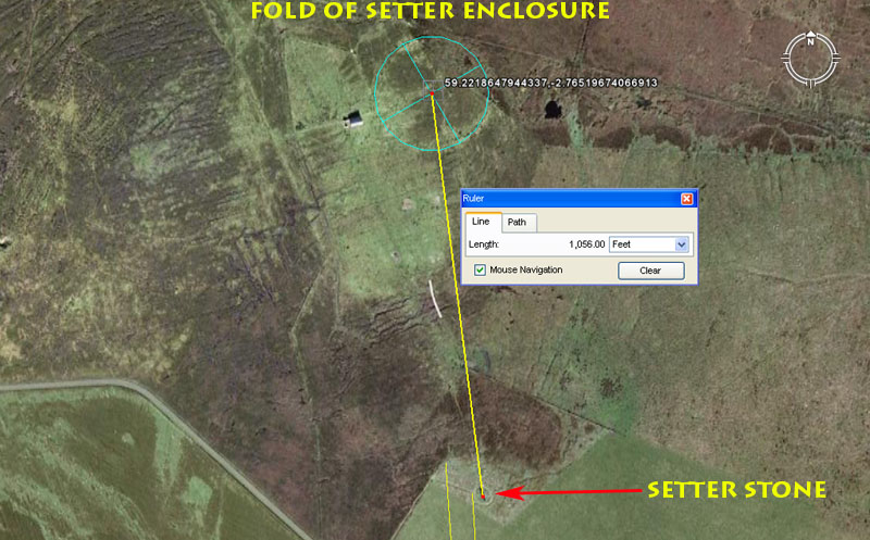
THE FOLD OF SETTER CIRCLE ENCLOSURE.

The Fold of Setter circle is situated exactly 1056' (1/5th
of a mile of 5280') from the Stone of Setter @ 172.8-degrees return and these
coded values tell us that the preoccupation at the circle was in teaching how
to convert "mile" diameters into circumferences, used for positional
plotting at sea. The forms of PI used in this exercise varied, depending upon
the number family being calculated. PI would be represented as either 3.125,
1728/550ths (3.141818182)*, 22/7ths
(3.142857143) or 3.15. By this means, factorable linear numbers that were used
repeatedly in ancient metrology could be converted into factorable circumferences.
*Footnote: The 1728/550ths ratio or PI expression
is built into the dimensions of Silbury Hill in Southern England, where one
cross measure diameter is 550' (100 ancient fathoms) for a circumference of
1728'. Note also that a cubic foot (12'' X 12" X 12 ") = 1728 cubic
inches.
The Fold of Setter appears to have an overall (outer) diameter of 297' and this is a subdivision of the ancient Scottish mile (5940'). The very dilapidated turf wall enclosing the site has a base width estimated to be about 7' (some of which could be due to slumping). This means that the resident Masters of the Craft could teach the merits of varied-diameter circles, in term's of Fold of Setter's OD, centre-crest to centre-crest diameter, as well as the ID. The fact of the matter is that the Fold of Setter simply acted as the prop for teaching general circle geometry, including how to achieve whole number, square-footage (area) readings using the PHI reciprocal. The use of the PHI reciprocal was essential to fabricating precise capacity volume tubs for use in the marketplaces of the cousin nations, such that patrons received the exact measures in dry goods that they had paid for. Let's explore some of the "mile-related" tutorials that would have been covered at this site.
1. Outer diameter of 297': This value is in homage to the ancient Scottish mile of 5940' (2970' X 2) and the sum of 297' is, therefore, 1/20th of the full mile. This ancient mile was 1-furlong greater in length than the English mile of 5280' and both miles were increments within the "11" family of numbers. Generally "sea-legs" of distance covered by a sailing ship were measured in leagues and "11" family leagues were 3.125-miles. The Scottish league would, therefore, have been 18562.5'
To convert this into a factorable circumference that could be subdivided into 360-degrees, the form of PI used was 1728/550ths or 3.141818182. Therefore 18562.5' X 1728/550ths = 58320' or 12 Roman miles of 4860' each. On this circumference, 1-degree of arc would equate to 162' and 1-minute of arc would be 2.7'. Note: the sum of 58320' would be 1/2240th of the 24883.2 Greek mile equatorial circumference.
2. If the tutors were elucidating about the English mile of 5280', then this would convert to a league of 16500'. Because this mile is also a member of the "11" family of numbers it is, again, converted to a circumference using PI @ 1728/550ths. Therefore 16500' X 1728/550ths = 51840' or 102/3rds Roman miles. On this circumference 1-degree of arc would be 144' and one minute of arc would be 2.4'. Note: the sum of 5184-miles would be 1/48th of the 24883.2-mile equatorial circumference.
3. The tutorial about the Irish mile of 6720' would categorise it as a "6&7" mile (divisible by both 6 & 7), like the Greek mile. This translates to a league of 21000' or 4 Greek miles of 5250' each. The Irish league is converted to a circumference using PI @ 22/7ths. Therefore: 21000' X 22/7ths = 21120'. Each 582/3rds feet was 1-degree of arc and every 1111/15ths" was 1-minute of arc. Note: 21120' is 4 English miles of 5280' each.
4. The tutorial about the Greek mile of 5250' would show how it converts to an English league using PI @ 22/7ths (16500'). It would have been mathematically convenient for this league rendition to be, simply, 3-Greek miles or 15750', converting to a circumference of 49500', with a degree of arc set at 137.5' and a minute of arc at 27.5". Nevertheless, @ 3.125 Greek miles it would have a length of 16406.25'.
A thorough comparison of the very close proximity variations indicates that the Scottish Mile was 5940' with an ell of 37.125". There would be 1920 ells in the ancient Scottish mile and 8 ells would equal 24.75'.*
*Footnote: Apart from the 24750 value being used to describe the equatorial circumference of the Earth under the "11" family of numbers, it also features (@247.5-degrees) as a division in a 360-degree circle where there are primary (quarter segments) and secondary (eighth segments), etc. The sum of 247.5-degrees is an expression of dividing up the circle into sixteenth parts and 247.5-degrees would designate the position of West-South-West. The most used compass angles are:
0 (N), 22.5 (NNE), 45 (NE), 67.5 (ENE), 90 (E), 112.5 (ESE), 135 (SE), 157.5 (SSE), 180 (S), 202.5 (SSW), 225 (SW), 247.5 (WSW), 270 (W), 292.5 (WNW), 315 (NW), 337.5 (NNW), 360 (N).
We must remember that these British sites, extending from Southern England to Scotland or Ireland, were major centres of learning for the "Sea Peoples" (the Pelasgians) who ranged far afield in their ships and needed an intricate mathematical knowledge of circle geometry for positional plotting and dead-reckoning at sea.
Journeys undertaken in in sailing vessels were dependent on the
wind direction and had to be made in a series of zigs & zags across the
ocean. The length and angle for each zig and zag (sea-legs) had to be carefully
scaled and marked on a plotting chart, then the "full-league", linear
legs covered turned into a calibrated circle on the chart. Because the length
of the leg (in full "leagues") was known, the scaled circle created
therefrom was accurately divisible into degrees, minutes and even seconds of
arc, within a 360-degree environment. By this means, coupled with the navigator's
ability (experience) in estimating boat-speed and precise bearing, the distance
and angle back to the point of departure could always be known.*
*Footnote: This is what is symbolically referred to in the
Greek mythology about Theseus using string to mark his path
into the labyrinth, where he goes to seek out and kill the dreaded Minotaur
(a blood-thirsty monster with a hereditary link back to Poseidon, god of the
sea). Having accomplished this dangerous quest, Theseus had to retrace his steps
back through the complex maze to the doorway (portal or port) where he had entered
in.
Beyond all of the discussions of "miles & leagues" at Fold of Setter, there would have been tutorials about the lunar cycles and how to plot or monitor them within calibrated circles. Knowing the exact position of moonrise or set, as well as the "waxing & waning" aspect of the moon within the monthly cycle, was essential information to navigators, who used a lunisolar calendar system to keep track of Sun & Moon rise & set positions on a daily basis, as well as the date.
The Fold of Setter stands 10206' from Bay of London hub-mound and this distance is lunar coding. The lunar period monitored within the lunisolar Sabbatical Calendar was 2551.5-days (7.2 lunar years ... tracked alongside 7-solar years or 2556.75-days). The sum of 102.06-days represented 1/25th of the Sabbatical Calendar lunar period. From the Bay of London hub-mound, the Fold of Setter circle is bracketed by two vectors, @ 175-degrees return (lunar & navigational coding) and 177.1875-degrees (lunar coding), respectively. These bracketing vectors were symbolically represented as "horns" and thus we have the "horns of Herne the Hunter" of Britain bracketing a solar orb, or the "horned crown of Isis" of Egypt bracketing a solar orb, etc. In a more literal sense, the orbs were circular surveying markers, such as the standing stone circles, mounds, chambered cairns, ring barrows, pond barrows, etc., that stood at coded distances & angles away from the main hub position. These outer targets were often bracketed by vectors, such that the overland navigators knew the centre-range in which the target location sat.
BRAESIDE CHAMBERED CAIRNS.
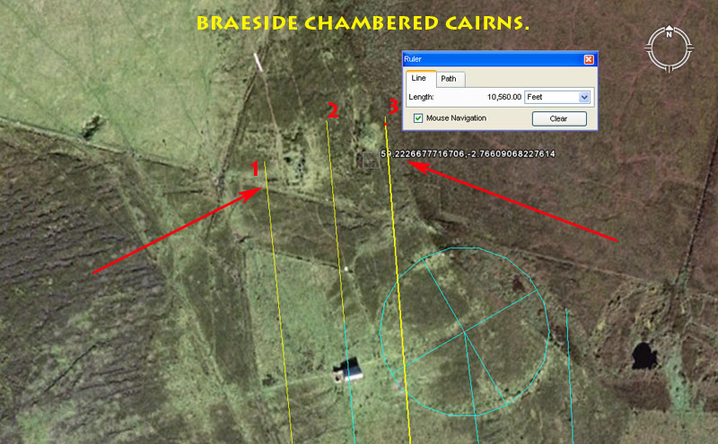
A short distance NNW of the Fold of Setter are the dilapidated remains of two chambered mounds and it seems obvious that the tutors working at the large Fold of Setter circle resided nearby (seasonally at least) in a local, support community.
1. One of the cairns sits at a coded distance of 10500' from the Bay of London hub-mound and a vector angled @ 354.375-degrees sweeps past its western face. The 10500' distance equates to exactly two Greek miles of 5250' each.
The azimuth angle of the bracketing vector (354.375-degrees) is, in days, the exact duration of 1 lunar year (354.375-days).
2. Another vector skims past this cairn at a central position that also brackets the cairn slightly further to the ENE. That cairn sits 10560' out from London Bay hub-mound and this distance is exactly two English miles of 5280' each. This central vector has a return angle of 175-degrees. The sum of 1750' would be 1/3rd of a Greek mile, whereas 1760' would be 1/3rd of an English mile.
3. Brushing the eastern side of the cairn is another vector set to 355.55555-degrees (3555/9ths). In a mathematical progression this value generates many useful numbers much used in navigation, such as 1066.6666 and ultimately 3200. The French or Gauls had an ancient foot set at 1.06666666' or 12.8". In addition, the 360-degree circle system is dual calibrated to be both 360 divisions and 320 divisions simultaneously. A very close proximity value is generated when dividing the 24883.2-mile equatorial circumference by 70.
HUNTERSQUOY CHAMBERED CAIRN.
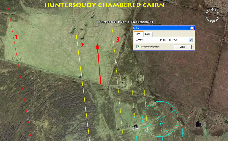
The area just NW of Fold of Setter seems to have been a small community centre with several chambered cairns clustered near to each other. Huntersquoy chambered cairn sits 11000' from London Bay hub-mound and is bracketed by two significant degree angles.
1. A red line is seen to pass through the western side of the site. It resolves at Vinquoy chambered cairn.
2. A line runs for 11000' (navigation) and resolves to the western side of Huntersquoy chambered cairn. The return angle is 172.8-degrees (navigation, weights, measures, volumes).
3. A line runs for 11000' to resolve at the eastern side of Huntersquoy chambered cairn. The angle from London Bay hub-mound to this point is 354.375-degrees. Note: Half the base length of the Khafre Pyramid of Egypt is 354.375' and there are 354.375-days in a lunar year.
LINKERTAING CHAMBERED CAIRN & ROUNDHOUSE.
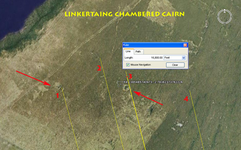
On the West side of Linkertaing Hill is a former small community settlement that includes a chambered cairn and the remains of a roundhouse. There is also evidence that there was once a compound or enclosure here, as well as straight walls (dykes), but everything is now very dilapidated.
1. This is the position of what the archaeologists are referring to as a roundhouse. In terms of distance and angle away from London Bay hub-mound, the position would appear to be very significant. It sits 16800' out @ a return angle of 165-degrees.
The 16800' distance is 2.5 Irish miles. The value features very strongly in mathematical progressions and generates navigational numbers.
The return angle is coding related to increments in the "11" family of numbers. The rod or perch was 16.5' and the league was 16500'.
2. It seems obligatory that on this site the dynamic lunar value 16875 would be represented and this is an example of where the line would fall within the compound area. The angle that accompanies this vector is 345.6-degrees (navigation).
The 16875' length would generate a lunar progression. There would be 21 intervals of 16.875-days in a lunar year, etc.
The degree angle relates to navigation and the sum of 345.6-miles would be 1/72nd of the Earths 24883.2-mile circumference.
3. The chambered cairn is situated 16800' out @ 165.888-degrees return.
The 24883.2-mile equatorial circumference ÷ 15 = 1658.88-miles.
4. It seems obligatory that the value 16666.66666' would have been represented. This vector has a return angle of 166.66666-degrees.
The 1.6666666 value featured prominently in ancient calculations and the shortest side of a 3,4,5 triangle will be 1.6666666 less than the hypotenuse value.
TWO-COMPARTMENT STRUCTURE AT EDAY'S N.E. COAST.
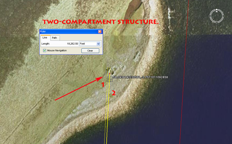
On Eday's NE coast is this anomalous structure, referred to as "An unroofed structure comprising two adjoining compartments, one circular and one rectilinear..". The structure sits in a significant position that provides very important solar and lunar cycle coding in terms of its distance and angle away from London Bay hub-mound. The red line shown to the right runs from London Bay hub-mound to the most extreme northern tip of Eday Island.
1. The distance is 18262.5' @ 2.6-degrees. The solar year endures for 365.25-days and the half-period is 182.625-days. This is also the day count from Equinox to Equinox. Under the ancient Sabbatical Calendar system, the year ran for 52-weeks ... or 26 by-weeks ... or 13-months of 28-days each ... or 364-days. The calendar was permitted to run like this for seven years and accrued 1.25-days of error per annum accordingly. At the end of the seventh or Sabbatical year, a nine day festival was held in which the corrective, intercalary days were added back in prior to the commencement of the next Sabbatical period. The solar period for 7 full solar years is 2556.75-days or 182.625 (1825/8ths) X 14.
2. The Sabbatical Calendar was lunisolar and tracked the cycle
of the Moon alongside that of the Sun. A difficulty arises however, in a mathematical
sense, in that the lunar year is 11-days shorter than the solar year. To overcome
this disparity the Sabbatical Calendar system was created, wherein 7-solar years
(2556.75-days) was monitored alongside 7.2 lunar years (2551.5-days). Ancient
astronomers would wait until the 6th day after the beginning of the solar count
before commencing the lunar count. That way, both periods would come to an end
on the same day 7 full solar years later.
With the lunar count running for 2551.5-days, 1/14th
of that period was 182.25-days (1821/4th),
so as long as the students could remember that the value (1825/8ths)
related to the sun whereas the value (1821/4th)
related to the Moon, then the base increments and mechanisms of the lunisolar
count could be retained. It's probable that the eastern-most compartment of
the structure mnemonically (if not literally) represented 18225'
from London Bay hub-mound.
Whereas the western-most compartment of this site sits at an intended
2.6-degrees, the eastern one sits at 2.625-degrees. The double-value of 2.625
is 5.25 and this increment was essential to counts within the lunisolar calendar.
The full solar count (2556.75-days) was 487 X 5.25-days, whereas
the lunar count was 486 X 5.25-days. It is because of the importance
of this value that 5250' became the length of the "so-called" Greek
mile, whereas the "so-called" Roman mile was 4860'. Also, the half-reed
(10.5') was 5.25' and the Greek short stadia was 525'.
There would be 13.5 intervals of 26.25-days in a lunar year.
It appears quite clear that this site was created to teach students the lunisolar Sabbatical Calendar system, which was essential knowledge for navigators.