BEYOND MAINLAND ... A DAY-AWAY AT EDAY.
Whereas the Google Earth images of Mainland Island are (often) either enshrouded in cloud, very dark or shown in low resolution, the same is not the case at Eday Island, which is clear and bathed in sunlight. It's many chambered cairns, burnt mounds or even standing stones can, for the most part, be positively identified on the landscape. Little Eday Island offers us a unique opportunity to see how an ancient complex of surveying markers worked from the island's central hub-mound.
Although Ring o' Brodgar remained the hub and primary training ground for students of navigation at the great Orkney Islands school, the many surrounding islands contained their own surveying markers for additional, extended training. More advanced students, who had mastered the rudimentary principles of navigation and seamanship, needed to cross significant bodies of sea-channels to get to these outlying classrooms. On each outer island was one carefully-placed, preeminent hub position, which stood at a precisely surveyed distance and angle out from the centre of Ring o' Brodgar. Student navigators would set out from Brodgar to a prescribed point of the Mainland coastline, then navigate to that outer-island hub position. From there they could recommence a whole new set of navigational tutorials, under guidance of the resident Masters of the Craft. For Rousay Island the main hub was Knowe of Lairo long chambered cairn, For Eday Island it was Bay of London Mound, a laboriously built and strategically-placed hump that now sits adjacent to the old foundations of a long abandoned church.
As we look at each survey-marker structure, the intended, refined values that had been encoded into them by their builders will be discussed and elaborated upon. It goes without saying that the precision mentioned (down to fractions of inches) were not achievable in a literal sense and it took the participation of a knowledgeable Master of the Craft to identify the finalised numerical-value (factorable number) to the students and explain its merits. The outlying mounds or cairns could be 50' across and have multiple coded vectors resolving either to their sides or onto their more central regions. Greater refinements of position were found in the limited dimensions of lone standing stones, but the constant participation of the learned Master remained essential until the students had memorised the correct, refined, encoded values that worked fluidly in mathematical progressions.

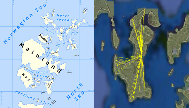
Little Eday Island is shown centred between Westray, Sanday, Rousay and Stronsay in the island grouping north of Mainland. For this study, Eday Island offers many advantages, as the Google Earth image is cloudless and visually clear, unlike much of Mainland Island where Ring o' Brodgar is situated.
The general, overall region of scattered islands was a perfect training ground for ancient student mariners and navigators, as it offered ever-increasing levels of difficulty in negotiating the landmasses, lochs and waterways in and around the islands ... until one was sufficiently competent and experienced enough (or foolhardy enough) to take-on the rigours and full fury of the dangerous North Sea.
The amount of work that was undertaken to create this vast school complex in a sub-arctic environment is extraordinary . There is a diverse assortment of surveying markers, purpose-placed across the vast landscapes, many of which double as chambered hostels and dormitories for ever-transient student groups coming and going. The mammoth undertaking to build such a huge, carefully premeditated and designed, inter-island complex suggests the cooperative-effort of several large nations working in unison for a common cause. A huge support network would have been required to produce food & clothing for the tutors & students, as well as the re provisioning (cleaning-restocking-repairing) the many scattered hostel classrooms where the students congregated in small groups for their tutorials, food and rest.
The many yellow vectors seen in the Google Earth image to the left, accurately depict alignments running from the Eday Island hub to the outer marker positions around the island. Each line shown is carefully coded by way of distance and angle. It was the task of the students of navigation to learn all of the coded numbers and how to apply them in positional plotting, such that safe traversals of the world's oceans was possible. The (red) code-bearing line running SW across the channel resolves at the centre of Ring o' Brodgar on Mainland.
LONDON BAY HUB-MOUND, EDAY ISLAND.
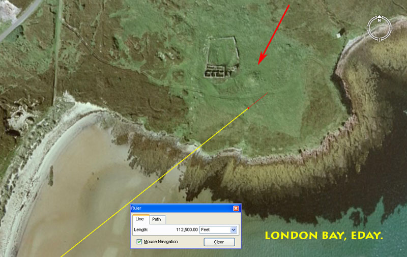
The line shown runs for 112500' from the centre of Ring o' Brodgar at an azimuth angle that is exactly 1/7th of 360-degrees. Under the 360-degree system, the sum of 11.25-degrees represented 1/32nd part. The line resolves very close to the mound after running for just over 21.3-miles from the centre of Ring o' Brodgar. This hub-mound is situated at the midway point of the island, where the eastern and western coastlines are closest to each other and offer wide sandy beaches, on each side of the island, for making boat landings.
In choosing this location for building the hub-mound, the positions of several regional high hills would first have been considered and a due East marker stone would probably have been erected on the Fers Ness Peninsula. The nearby hills tend to have long sweeping summits and it would have been up to the surveyors to choose spots for refined trigs (a standing obelisk or cairn) where convenient degree angles fix points could be established. Atop Ward Hill, for example, a whole number angle of 197-degrees to a summit standing stone would have been achievable. Once an accurate outer marker at a known degree angle had been erected, then it could serve the hub-mound every time the ancient equivalent to a theodolite (alidade sighting-rule) was being set up for accurate degree angle fixes to targets around the horizon. Angles out to the highest visible hills in view on all of the surrounding islands, even to Cuilags at Hoy 25-miles distant from Eday (if it could be seen), would be known in relation to each hub-position around the Orkney Island group. These high hills throughout the archipelago would have been exploited from every possible vantage point.
Now, using the crown of the ancient mound at London Bay as the hub position, let's measure the distances and angles to all known ancient markers throughout Eday Island, such that we can detect and extract the in-built coded values encoded therein by the original architects of 4-5000 years ago:
VINQUOY HILL CHAMBERED CAIRN.
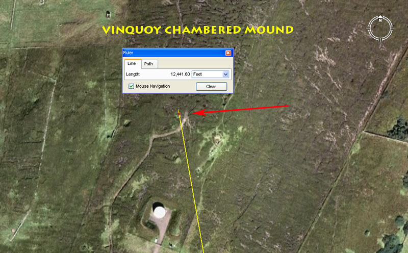
The Vinquoy Hill chambered cairn (arrow right) is, perhaps, Eday's best known archaeological site. It has a diameter of about 56 - 58' and stands 8' high. Its entry leads to a central chamber, off to the side of which are four cells or sleeping quarters. From this elevated, chambered cairn commanding views are available across the Orkney archipelago.
The cairn is situated 12441.6' from the crown of London Bay mound at an azimuth angle 350-degrees.
1. The sum of 12441.6' is, of course, coding related to the equatorial circumference of the Earth under the "6&7"-based navigational system, which used a Greek mile of 5250'. Under this system, 1-minute of arc was 6048' and 1-degree of arc was 69.12 (Greek) miles. For navigational purposes, the Earth was considered to be 24883.2-miles in circumference, of which 12441.6-miles was the half value. This distance at Eday is, therefore, a scaled representation of half the equatorial circumference, @ 1' = 1 Greek mile.
2. The angle (350-degrees) is navigational and is also related to the Greek mile (the sum of 350' is 1/15th of 5250').
3. Another very close proximity degree angle reading that would have been included in tutorials related to this site is 170.1-degrees return to London Bay hub-mound. It would not be surprising to find an obelisk or significant stone situated to the East of Vinquoy chambered cairn that marked this alignment. For anyone wanting to have a look, the ancient stone or cairn surveying marker should sit about 22' East of the doorway.
This second reading of the degree angle relates to the cycle of
the Moon, wherein it moves from major-standstill to minor standstill, then back
to major standstill again in a cycle spanning 6804-days.* The sum of 1701-days
is a quarter period of the cycle. The same kind of lunar encoding was built
into both the southern circle of Avebury Henge and Ring o' Brodgar, wherein
both circles have intended diameters of 340.2'. These diameters are in homage
to 3402-days, or half the duration of the lunar nutation cycle (major-minor-major
standstill cycle).
*Note: The duration of the cycle is actually 6798.36-days, or 5-days
less than the 6804-day period used in ancient calculations within the lunisolar,
Sabbatical Calendar system. However, despite the minor discrepancy, ancient
mathematicians always used factorable numbers that could be easily subdivided
or multiplied. They would accept very small amounts of error in order to describe
either the equatorial size of the Earth or the duration of cycles in factorable
numbers. By this method, calendars could run for several years before the addition
of a few intercalary days was deemed necessary. Likewise, the fully-factorable
values used to describe the circumference of the Earth were so close to the
Earth's true dimensions that very accurate positional plotting at sea was achievable.
By using factorable numbers the world could be grid-referenced and one could
subdivide the whole down to a single inch or fraction thereof.
SETTER STONE, ADJACENT CAIRN & NEARBY BARROWS.
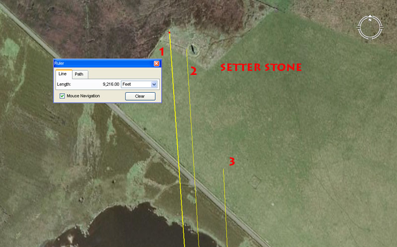
1. The National Monuments Record for Scotland states that a cairn is situated at this point. The position would closely comply to 9216' @ 176-degrees return.
2. Setter Stone: 9131.25' @ 356.4-degrees.
3. A possible barrow hump is said to exist at this position, which would comply to 8640' out from the London Bay hub-mound @ 177.1875-degrees return.
MILL LOCH CHAMBERED CAIRN AND NEARBY STANDING STONES.
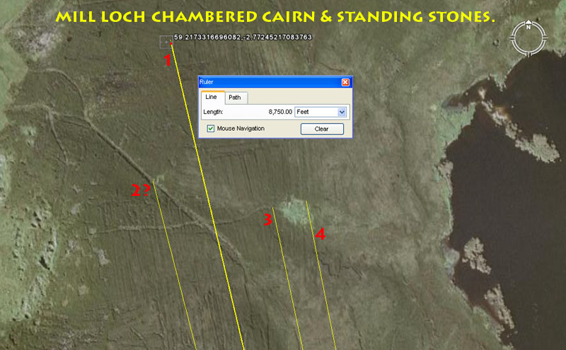
1. The National Monuments Record for Scotland states that one of the standing stones is situated in the bracken at this point. If that is so, then the position would comply to much used ancient codes of distance and angle. The distance would be 8750' (lunar coding) @ 166.66666-degrees (navigational coding) return to London Bay hub-mound.
2. The National Monuments Record gives no clear position for the other stones, but it can be seen that visitors using the track to the chambered cairn are detouring and milling about at this position. Perhaps this is where another of the former standing stones reposes? It would closely comply to a code of 8333.33333' @ 345.6-degrees (both much-used values in ancient navigational calculations).
3. One vector falls to the West side of the Mill Loch chambered cairn, which is 8167.5' (calendar related coding) out from London Bay hub-mound @ 168-degrees (strong navigational coding).
4. The other vector skims the East side of the chambered cairn @ 168.75-degrees (strong lunar coding).