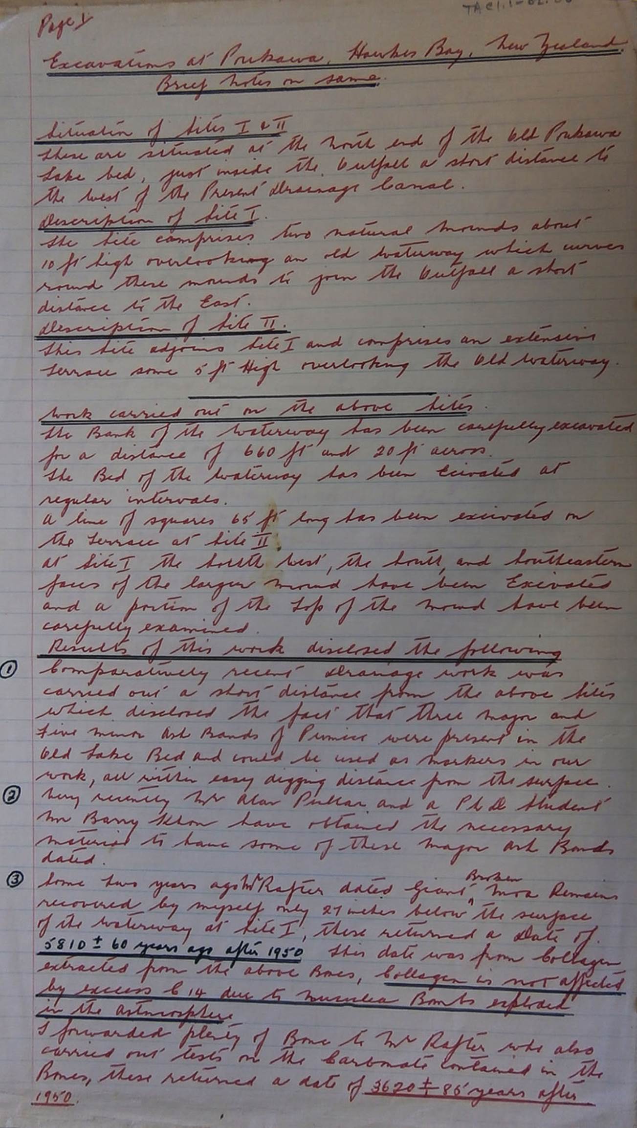
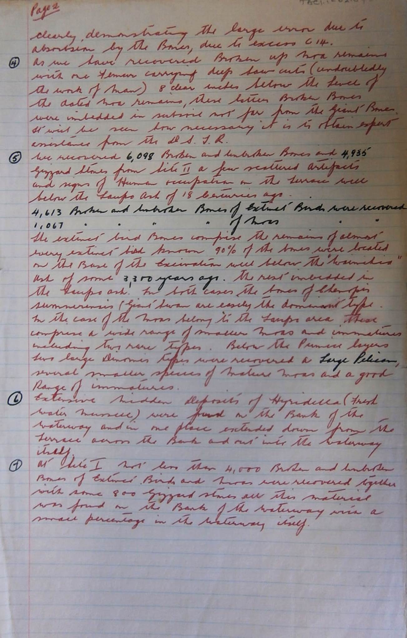
Price wrote the following in his 1963 report for the New Zealand Archaeological Association:
SITE 1:
Digging Operations:
Operations commenced on 6 October 1962 at the foot of the spur with the fireplace at its crest. A total area of 52ft X 24ft was dug, this area including the stream bed and low bank which slopes gently up to the base of the spur.
The surface layer is composed of friable, reddish-tinted peat free from timber, followed by a thin layer of coarse pumice; smaller bird remains, extinct swan and nortornis were found in this layer. Below this is a further layer of friable peat. The main pumice band is then encountered, this comprising fine white pumice considerably compacted in places. The majority of moa remains were encountered just under, or near this band. Layer 5 is a mixture of peat, hyridella and matai seeds, the hyridella shells being large but decayed owing to the fact that they had been heated. Hyridella shells found in the 1931 bed of the outfall are in good condition and antedate the decayed shells by a considerable period of time. The deposit is convex in shape, lies parallel to the stream bed, and is some fifty feet in length and from six to eight feet across. Proving trenches have been dug to east, west and south of the site, and illustrate quite clearly that both this deposit and the bone deposit are localised in front of the fireplace. Carbonised wood and blackened peaty soil are also found embedded in this layer.
The next layer encountered is composed of hard peat though which numerous cracks run giving one the impression of water-borne which has settled over a considerable period. This in turn rests on a deposit of fine fresh water in which are embedded numerous pieces of small wood and twigs; moa remains were also found here. Ground water prevented further digging.
A typical profile reading is:
Layer 1 Peat, 6ins, broken moa bones
Layer 2 Coarse Pumice, 1/4in., nortornis and swan
Layer 3 Peat, 4ins, odd moa bones
Layer 4 Fine white pumice, 4ins. No findings
Layer 5 Hyridella, matai seeds, etc,. 2ins, immature moa bones
Layer 6 Compacted peat, 8ins, moa bones resting on, or embedded in
Layer 7 Fine shells, 2ins, a few moa and swan bones
Results:
Twenty six major moa bones, 42 claw and toe bones, 52 various vertebrae, 3 craniums, 166 ribs or portions, fragments of pelvis and sternum, 31 immature unbroken bones, and 50 broken; 108 unbroken bones of other extinct birds, 235 broken, 6 craniums, 2 nortornis beaks, greywacke gizzard stones, and a number of black stone and red quartz gizzard stones – all foreign stone to the district.
Items
directly related to man found below the pumice band: one split slab of matai,
cut neatly in half by a sharp instrument. The slab is 8ins across, and 2 ![]() ins thick and was embedded in layer 7. Directly under
the slab were found the remains of a fully-grown giant swan, whose bones are in
the finest condition. The discovery was made by B. Cummings on 1 Dec. Two
pieces of totara which had been sharpened by man were also found; one piece had
been partly bored. Also, in layer 7 were six sandstone and greywacke stones
used by man. In layer 4 was a Dinornis skull cleft by an oblique blow by a
sharp instrument.
ins thick and was embedded in layer 7. Directly under
the slab were found the remains of a fully-grown giant swan, whose bones are in
the finest condition. The discovery was made by B. Cummings on 1 Dec. Two
pieces of totara which had been sharpened by man were also found; one piece had
been partly bored. Also, in layer 7 were six sandstone and greywacke stones
used by man. In layer 4 was a Dinornis skull cleft by an oblique blow by a
sharp instrument.
In consideration of the above, let’s explore the significance of these layers and the positions of manmade or human utilised objects above, within or below them:
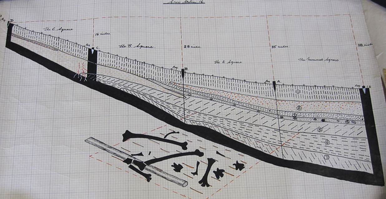
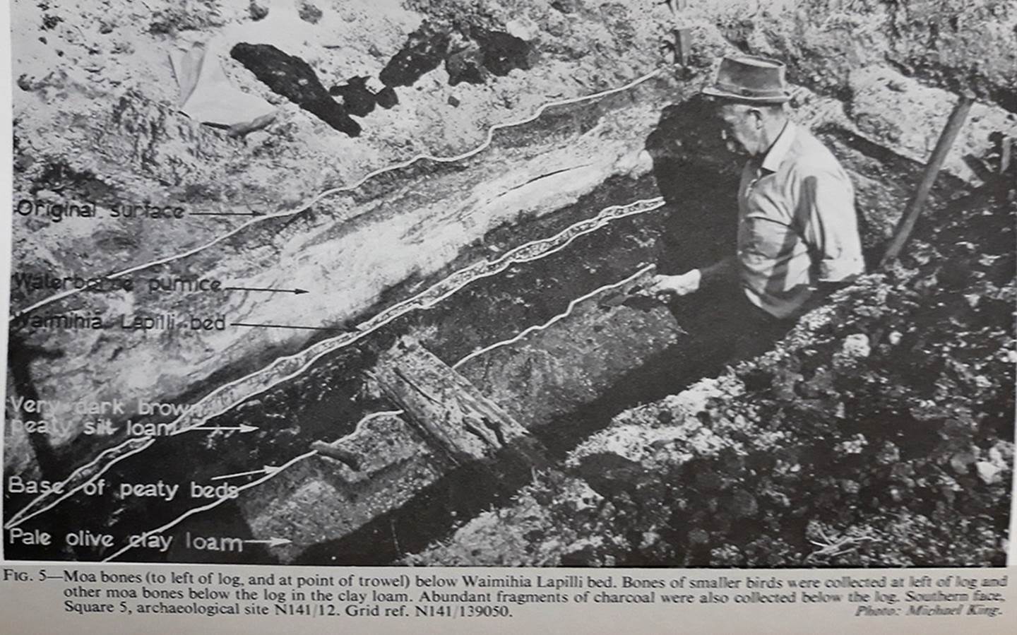
This is but one of many cross section, scaled drawings completed by Treaton Russell Price during the 25-years or so that he devoted to multiple, careful digs at the Poukawa sites. As investigations continued it was found that many cooked Moa bones, often broken into short lengths, presumably for the purpose of sucking out the marrow, lay beneath the undisturbed ash band of 186 AD. It was further ascertained that many of these cooked, broken-up bones, had cutting tool, score marks on them and lay beneath the undisturbed Waimihia ash band of circa 1340 BC. The same held true for human made or modified artefacts in wood, bone, stone or shell. Despite clear evidence of ancient, pre-Maori occupation, Price remained reticent in not expounding his views too openly, pending a greater accumulation or data.
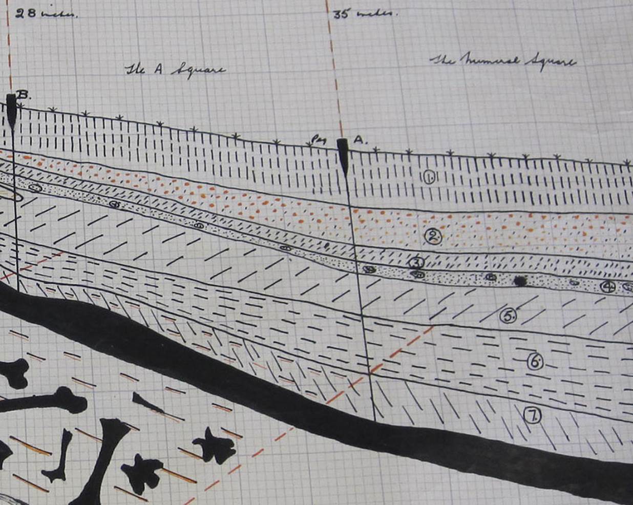
Note how Price has numbered the layers in this scaled cross section. So, to recap the meaning of the numbers:
Price wrote:
It was noted on profiles exposed by drainage that two pumice bands were present, the shallowest being course pumice and pellets, some of considerable size. The deeper band was composed of a fine white pumice and, in extreme cases was 10ins thick. This latter band, it is considered, reached the lake in a pumice flood some ten years after the Taupo eruption 1760 years ago.
Layer 1 is peat topsoil
Layer 2 is the gritty remains and larger lumps of volcanic pumice that rained down some ten years after the 186 AD eruption of Taupo.
Layer 3 is peat soil
Layer 4 is the pure, white, airborne pumice from the 186 AD explosion of Taupo.
Layer 5 is hard peat soil.
Layer 6 contains hyridella shells (freshwater mussels) in abundance and in excellent condition.
Layer 7 is cracked silty peat.
Layer 8 contains shells and twigs.
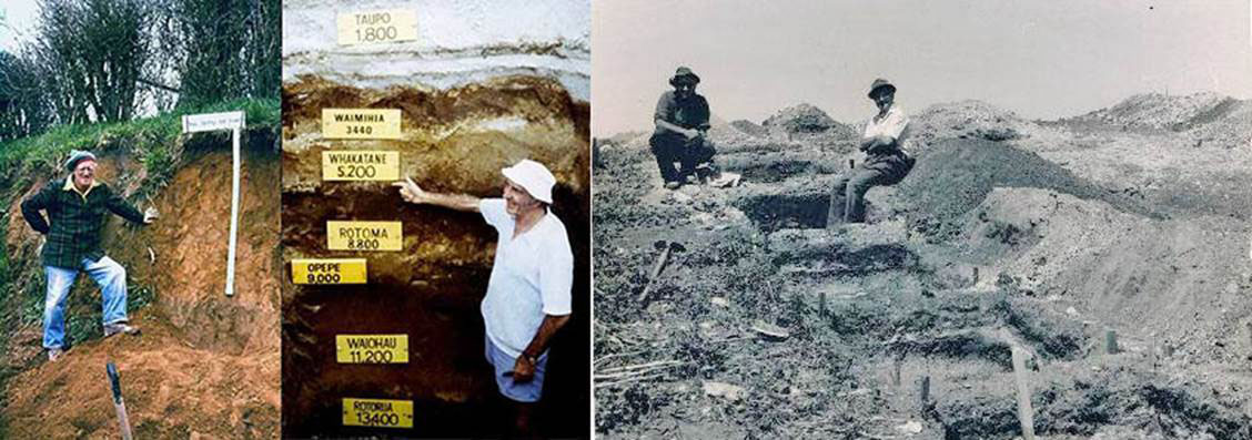
Left: In the 1950s and 1960s Alan Pullar (left) and Colin Vucetich worked for the DSIR Soil Bureau, mapping soils in the North Island. Vucetich worked around Rotorua, and Pullar in Gisborne and Whakatāne. They recognised that the soils were formed on volcanic ash layers, which were often visible in road cuttings. The men started tracing out distinctive ash layers across the region. Work on ash layers (later called tephrostratigraphy) was outside official Soil Bureau policy and was banned. Much of their work was therefore done in weekends and holidays on what they called ‘secret correlation missions’. Between 1963 and 1975 Vucetich and Pullar published a series of papers on the sequence and characteristics of the main volcanic eruptions in the Taupō and Rotorua region. This work has been the foundation for later volcanological studies as well as the understanding of soil properties. In the above picture Collin Vucetich has labelled the various ash layers by date and has the Taupo explosion listed as occurring 1800 -years prior, with the Waimihia explosion listed as 3440-years prior (1440 BC).
Right: Russell Price (upper left) and a colleague at the most major dig site which sat adjacent to Lake Poukawa (Site 4). Price had become aware of Pullar’s and Vucetich’s pioneering research into tephrostratigraphy and the very significant role it could play in his archaeological investigations at Poukawa.
Tephrostratigraphy, considered by the Soil Bureau as something of a pioneering science in the 1950s & 60s, quickly graduated to full respectability and acceptance. Within New Zealand, which has been very actively volcanic in certain areas and ages, the science now constitutes a major tool for dating geological strata or events.
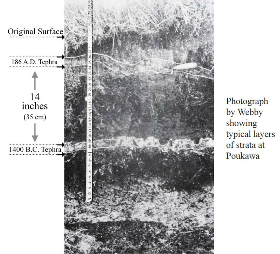
Again, a photo from one of the Poukawa archaeological excavations, showing the distribution of ash band layers. Any cooked and broken Moa bones or other manmade artefacts found beneath the Taupo ash band predated the Polynesian Maori epoch by 1100-years, or beneath the Waimihia explosion, by over 2100-years.
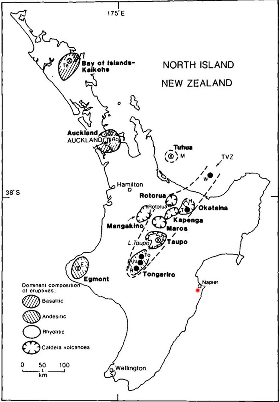
This map of New Zealand’s North Island shows the volcanic belt (A section of the worldwide “ring of fire”) extending through the central region. These volcanoes, several of which are dormant and others active, periodically erupt and, sometimes in the past, with extreme violence. The red dot marks the position of Poukawa in relation to the Central Volcanic Plateau. The Waimihia volcanic explosion came from a vent or vents within present-day Lake Taupo, preceding the later, violent Taupo eruption by about 1526-years.
Having found conclusive evidence of human occupation at Poukawa, going back to well before the 186 AD explosion of Taupo, Price moved his investigations 300’ WNW to another likely spot on the elevated spur and found yet another fire pit there as well. Russel Price writes:
SITE 2:
Digging Operations:
As we turned the first sods on 23 February 1963 on this site, we were full of hope, but felt we could scarcely do better than Site 1. By no stretch of our imagination could we envisage the vast wealth of evidence we were to find here. Work commenced at the foot of a low spur, and, as before, included the stream bed and the low slope to the foot of the rise. The total area dug to date is 52ft x 28ft south of our datum line, and 88ft north of this line.
The layers are much the same as found on Site 1, with the exception of the hyridella layer which is slightly concave and extends well up the low slope and is some 60ft x 40ft in extent. There are quantities of fine shells but no carbonaceous material. It is separated from the lower pumice band by hard peat, clearly defined, and is therefore older than Site 1.
Profile reading at maximum depth:
Layer 1 Peat, 1ft 2ins, with slight traces of first pumice band
Layer 2 Pumice, 2ins, some peat, matai seeds, hyridella
Layer 3 Pumice 3ins, with traces of peat
Layer 4 Pure white pumice, 3ins
Layer 5 Hard peat, 4ins
Layer 6 Hyridella with fine shells, 1in
Layer 7 Cracked, silty peat, 8ins
Layer 8 Fine shells and twigs, 4ins
Moa remains were found in Layers 1, 5, 6, 7 and 8. Some very fine giant swan bones were recovered from layer 3. Recent work has disclosed that the hyridella layer on the stream bank is heavily carbonised, and rests on limestone grit and pug. Moa, kiwi and nortornis remains have been found embedded in this layer, with matai seeds overlying it.
Results from Site 2, south of datum line, 88ft x 28ft:
203 major, unbroken moa bones; plentiful immature; 182 broken moa bones; 82 unbroken bones of other extinct birds; 54 broken bones of other extinct birds; large gizzard stones.
Results from Site 2, north of the datum line, 88ft x 8ft:
10 major moa bones; 201 broken and unbroken moa bones and fragments; 466 unbroken bones of other extinct birds; 797 broken bones of other extinct birds; 2,037 small gizzard stones (greywacke and quartz).
All these bones found on both sites lay horizontally with the exception of D. giganteus in Site 1; that is, only one bird was bogged. The articles that can be related to man are one soap stone foreign to the area, from Layer 7 at the foot of the slope, and one pumice disc worked by man, from Layer 3. Anything in the way of artefacts are likely to be found in and around the fireplace sites, and there is a lot of digging to be done before we arrive there.
So, in summary of these two digs, Price now had undeniable proof of human habitation in New Zealand antecedent to 186 AD, or 1100-years before the arrival of the Polynesian Maori. He recorded the following in his field book:
A handwritten record by Price concerning the Site 1 & 2 digs and the involvement of the DSIR in dating the results. He mentions: ‘As we have recovered broken up moa remains with one femur carrying deep saw cuts (undoubtedly the work of man) 8 clear inches below the level of the dated moa remains, these latter broken bones, were embedded in subsoil not far from the giant bones. It will be seen how necessary it is to obtain expert assistance from the D.S.I.R.’