SITE 3.
Treaton Russell Price, never doing anything by halves, had excavated two sites to show that both were locations for cooking, eating then discarding meal residues into the waters in front of the Moa hunter fire pits. However, he’d initially found a site where the method employed for capturing the giant birds was to panic and stampede them off the walking track and down into a bog, where they became stuck fast and had no chance of escape. Could it possibly be that there were other bog areas of the local terrain where the same hunt and capture method was being employed? Russell searched the farm and, by looking carefully at the contours of land fed by streams, finally decided upon a second likely area where there may be disembodied, sawn-off leg bones standing vertically in the subsurface mud.
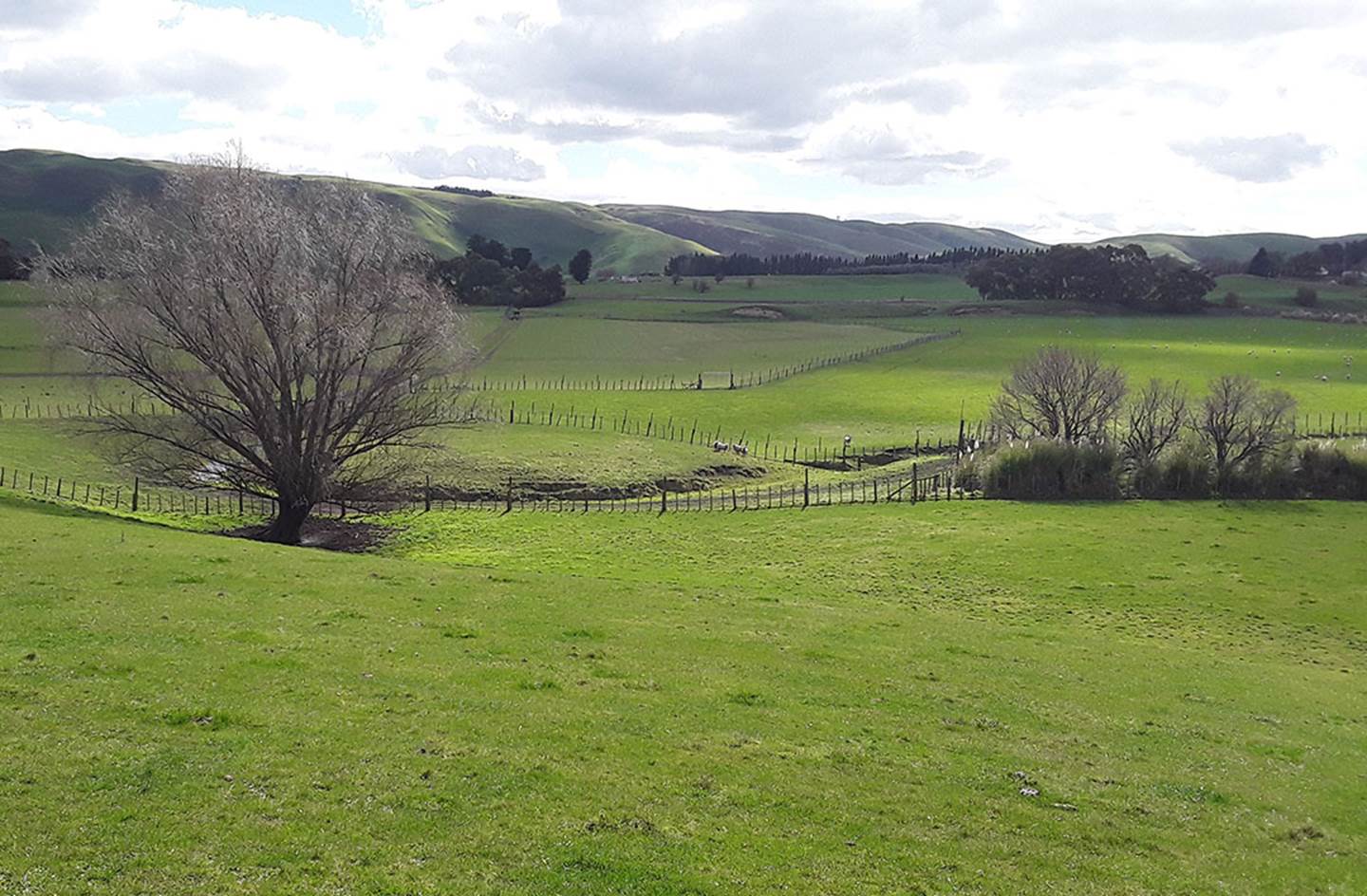
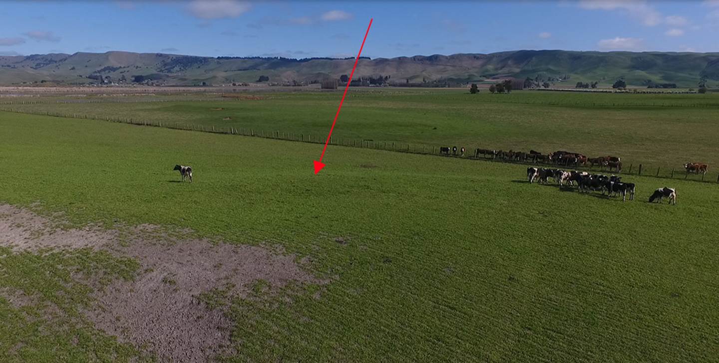
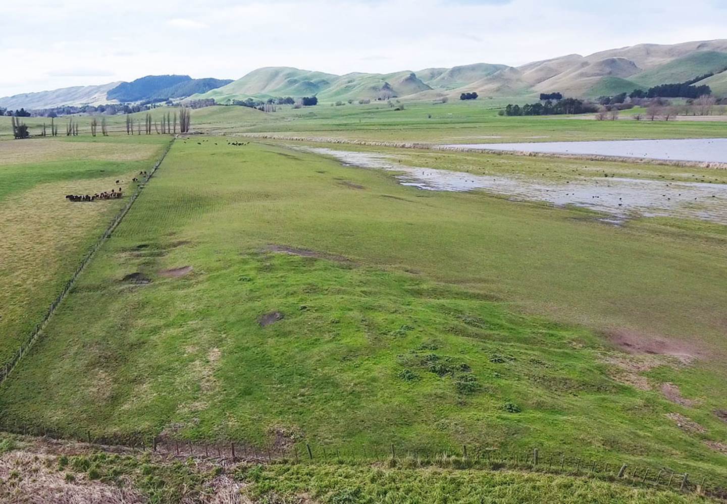
Treaton Russell Price decided that this location, at the base of a farm hill and near a stream bed, had the essential attributes for ancient hunters to herd Moa birds down into a bog from which there was no escape. The position where Russell undertook his dig to ascertain this fact approximates where sheep are clustered together near a fence line in the above picture.
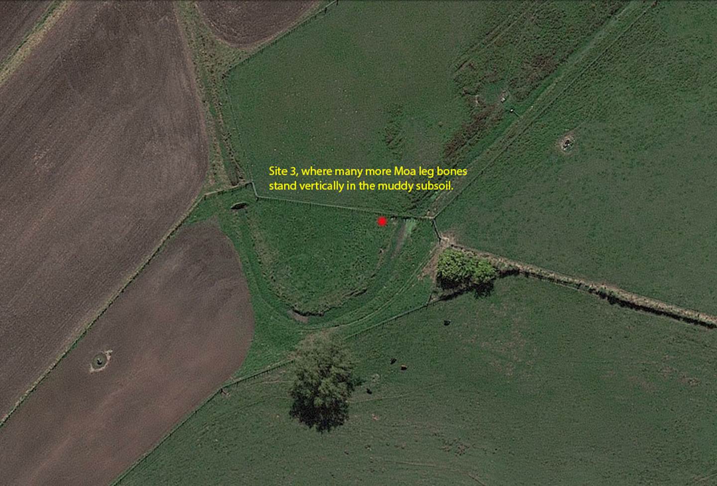
The coordinates of Site 3 are: 39° 46’ 02.01” S 176° 43’ 16.42” E
Russel Price wrote the following:
SITE 3:
Digging Operations:
Some work has been carried out on this site since 26 January 1962, to establish beyond doubt that the bones found, which had been partially cut through, had come from below the lower pumice level. All material from below this band is heavily mineralised indicating great age. The giant moa skeleton from which one of the partly cut through bones came, lay on the base of the stream bed in blue pug. The area dug was 20ft x 15ft.
Profile reading. (Note, no hyridella layer):
Layer 1 Black peat, no timber, 8ins
Layer 2 Brown peat, slight traces coarse pumice, 8ins
Layer 3 Coarse pumice, matai seeds, twigs and timber, 4ins
Layer 4 Fine white pumice, compacted in places, 6ins
Layer 5 Mud, branches, twigs and large charcoal blocks, 12ins
Layer 6 Sandy blue pug
Small moa remains were found in Layer 3, not mineralised, It was down this gently sloping area occupied by the meander, whose width is out of all proportion to the catchment area, that I consider a good proportion of the pumice flood entered the lake.
CONCLUSIONS:
It is all very well to be wise after positive proof has been obtained. It is now quite clear that a people living on a confined spur in an area teeming with bird life, as the avalanche of material indicates, would have to do something about the disposal of bones, not to mention hyridella. A warm spell of weather would hasten decay which would very quickly make the site untenable. They could bury the refuse or burn it, both tedious operations. All they had to do was gather it up, and throw it into the fairly deep, slow-running stream at their front door.
Here's what Russell Price handwrote in one small section of his 3 exercise books used in the field, in this case relative to excavations at Site 3:
Complete Record of All
No. on Label |
|
Description |
Species |
Position Relative to Band |
Remarks |
H No. 1 |
|
Portion of massive tibia Full break at small end |
Moa G, |
Unknown |
Hall Stream recovered From sedimentary deposit |
H No. 1 |
A |
Portions of massive bird Sawn in half and broken. Fracture surfaces old. |
Moa G, |
“ “ |
“ “ recovered from sedimentary deposit, traces of pumice |
H No. 1 |
B |
Portions of broken tibia Fracture surfaces old. |
Moa S. |
“ “ |
“ “ filled with sedimentary deposits
|
H No. 1 |
C |
Massive femur Broken at both ends. |
Moa G. |
“ “ |
“ “ Stained sedimentary deposit. |
H No. 1 |
D |
Large fragments of Broken massive Bone, probably femur. |
Moa G. |
“ “ |
“ “ sedimentary deposit. |
H No. 1 |
E |
Portion of cranium Massive. |
|
“ “ |
Hall Stream recovered From peat stained sedimentary deposit |
H No. 1 |
F |
Portion of broken tibia Fracture surface old. |
Not Moa |
“ “ |
“ |
H No. 1 |
G |
Portion of broken tibia Abraded at one end Small rib of fish |
Moa very small
Dolphin |
“ “
“ “ |
“ |
|
|
End of Investigatory stage of inquiry Jan 1st to Oct 1st, 1962. |
|
|
|
|
|
|
|
Start of inquiry Oct 6th, 1962. Bones found at South end of Poukawa Lake. Cold In morning. Fine in afternoon Wind S. |
|
No. 11 |
B |
Tibia broken at each end |
Aptornis M. |
Above … 6 inches in peat |
Oct 6th. |
No. 11/1 |
|
Tibia eroded at head |
Cnemiornis |
Below. 6 inches in peat. |
‘’ ‘’ Cell structure Similar to that of Pumices |
No. 11/2 |
|
Metatarsus head Broken off & 2 prongs broken |
Cnemiornis |
Below 6 inches in peat |
“ |
No. 11/3 |
|
Metatarsus prongs Broken off. Massive |
Aptornis M |
Below 6 inches in peat |
? of the bones will Have gradually fused Over long period of time. |
No. 11/4 |
|
Metatarsus head Broken off one prong broken |
Cnemiornis |
Below 4 inches in peat |
“ |
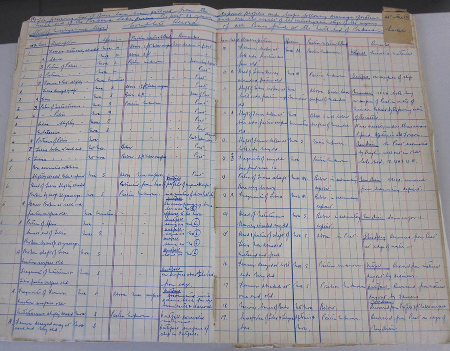
This is but a small sample copied from Price’s record of bird bones from (mostly) long extinct species that were recovered from Site 3. The list goes on almost interminably and demonstrates an obsessive-compulsive need to record every find and the clues that find might hold relative to human activity, from remote antiquity.
Again, a sample of a two-page spread within one of the exercise books. Similar books listed the artefacts made from bone, wood or stone as tools or ornaments, including some worked greenstone. It is quite certain that many cooked, obsidian knife-scratched bones, or other human-fashioned objects came from beneath the Taupo or Waimihia ash bands, thus dating the items to between 1100-years to 2200-years before the Polynesian Maori found New Zealand shores.
Although Russell
Price probably didn’t anticipate that he’d eventually have access to Thomas
Athol Rafter’s carbon dating laboratory at the Department of Scientific
and Industrial Research, outstanding finds at Poukawa gained the
attention of DSIR scientists and C14 analysis was undertaken by them in the middle
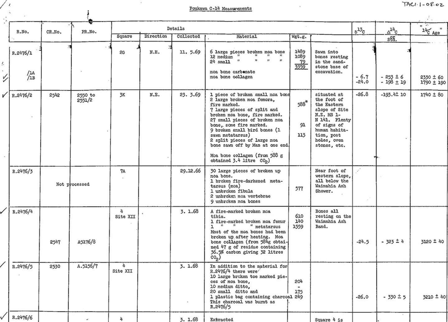
to late 1960s and early 70s. In the above results, moa bones that had been sawn
into by man returned C14 dates of 2330-years ![]() 60-years before 1950. Other cooked and broken up Moa bones
returned dates of 3120 -years
60-years before 1950. Other cooked and broken up Moa bones
returned dates of 3120 -years ![]() 40-years before 1950. Human handled bones or artefacts found
beneath the Waimihia ash band returned dates of 3440-years before 1950 and had mineralised
due to their great age.
40-years before 1950. Human handled bones or artefacts found
beneath the Waimihia ash band returned dates of 3440-years before 1950 and had mineralised
due to their great age.
SITE 4.
After several years of conducting digs at smaller, more confined sites, Russell Price moved to a raised peninsula-like strip of land that jutted partially into Lake Poukawa itself. Here he would undertake a very comprehensive set of digs over the next few years, into the 1970s, and make many remarkable finds. As usual, a datum line was established and strings were set out crossing pegs at 90° intersections, thus grid referencing squares into measured, numbered plots. The intention was to dig each 2nd square, while leaving an adjacent baulk wall undisturbed for future archaeologists to verify the results arrived at by Russell and his team.
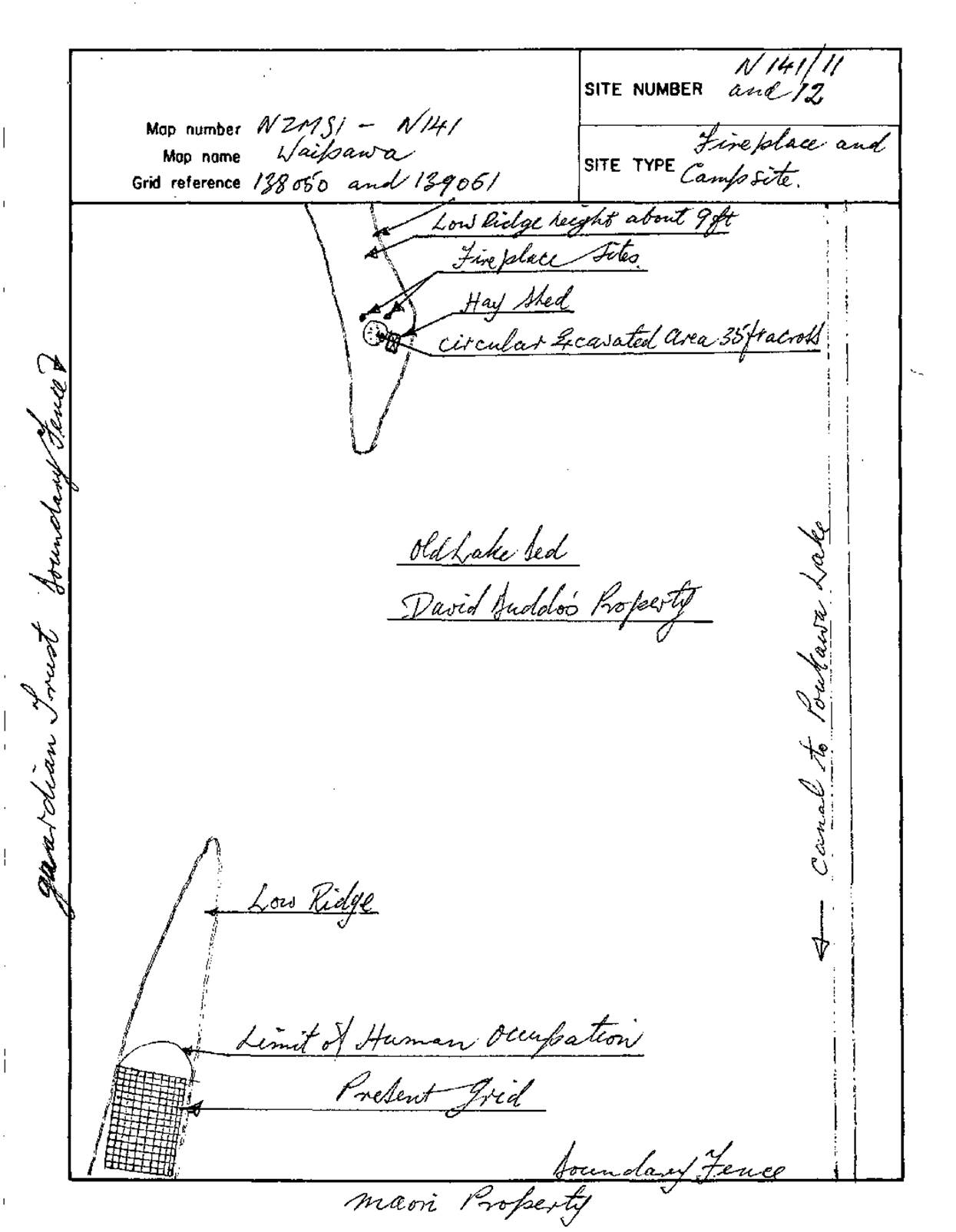
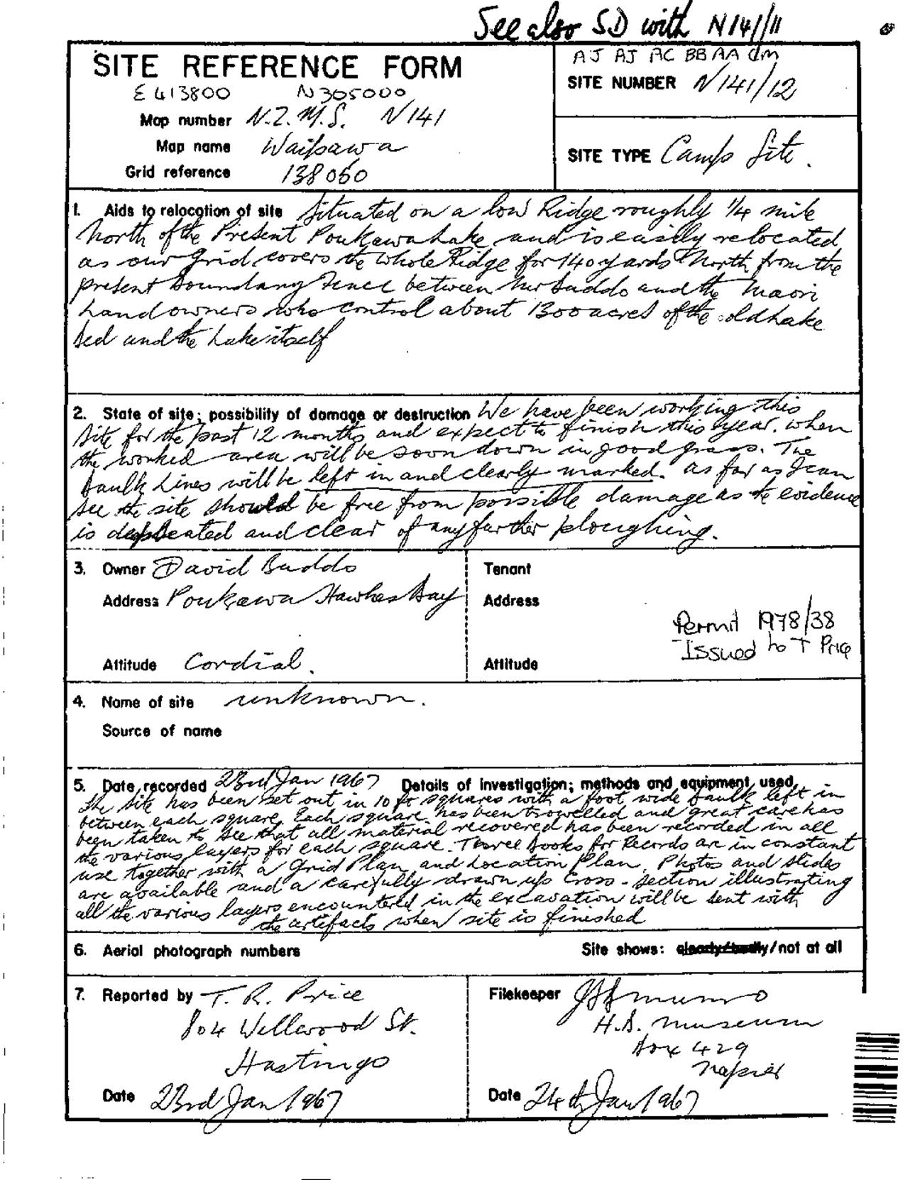
A map showing two digs in the general vicinity for Site 4 (141/11 & 141/12). The grid shown at the bottom left is where the very substantial, final dig took place. However, other work was undertaken adjacent to farmer, David Buddo’s hay shed drawn at the top of the map.
A successful dig was completed at this site and the depression where the large circle excavation took place is still evident on the summit of the low hillock.
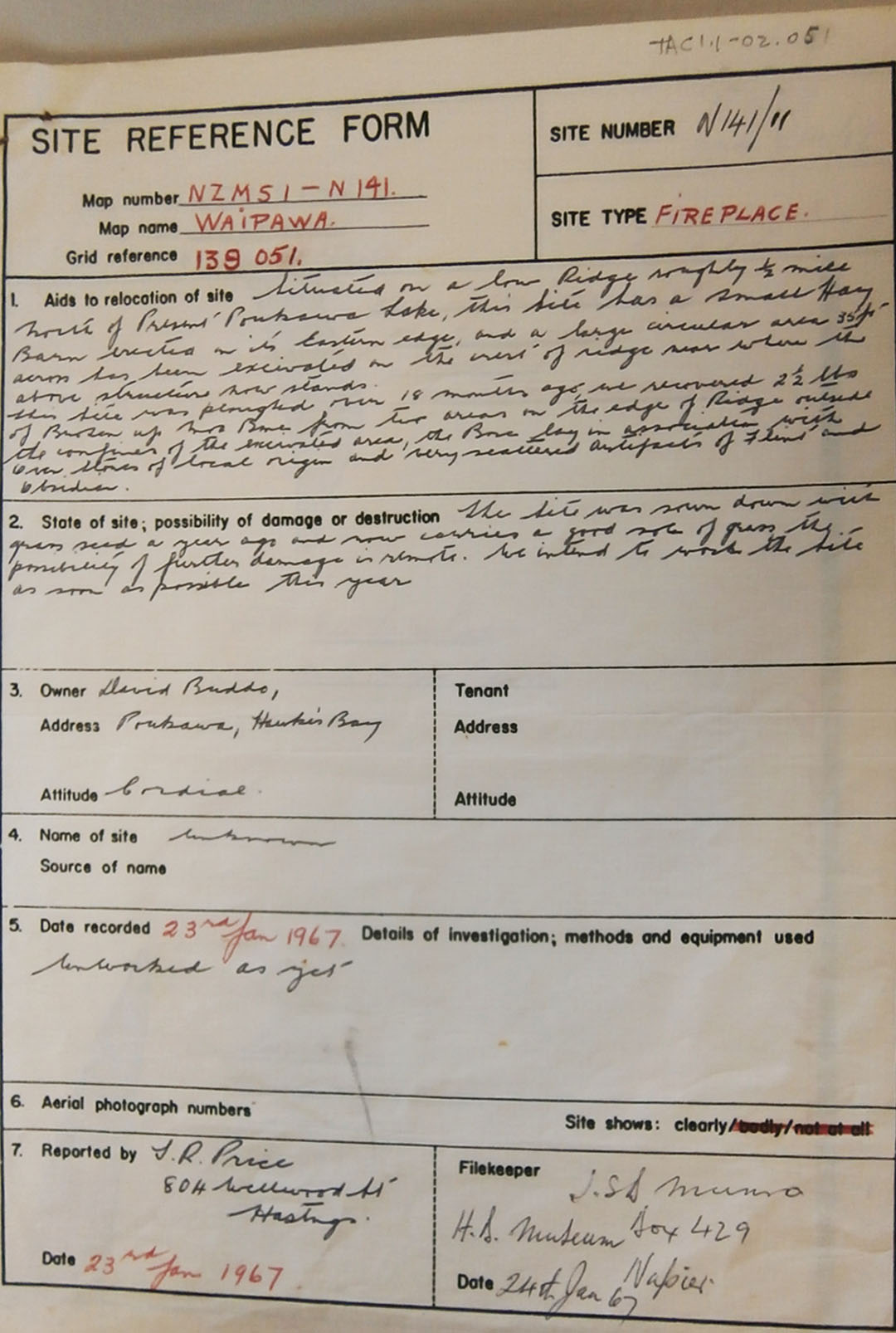
A brief description of the “Fireplace” site adjacent to David Buddo’s hay shed. Some shallow surface ploughing on the hillock had been done 18 months prior to cultivate grass, and 2½ pounds of broken Moa bones, as well as oven stones had been churned up and exposed in the process. However, these lay beyond the circular, 35’ wide confines of the much deeper archaeological excavation.
As a professional surveyor, Russell could lay out a site with meticulous precision, but was forever cognisant of the fact that he was regarded as an amateur archaeologist. He therefore had to conduct his digs “by-the-book”, so to speak, to avoid any future criticism of his methodology or approach. At the same time, he constantly consulted or involved credentialed professionals of several disciplines; archaeologists, geologists, tephrostratigraphy-volcanologist experts or the DSIR carbon-dating laboratory. His work and results were under constant scrutiny by seasoned professionals who took a keen interest in the unfolding, startling revelations it produced. Leading New Zealand scientist W. A. Pullar wrote:
NOTE ON ASH BEDS AT POUKAWA, HAWKES BAY
W. A. Pullar
Ash beds at Lake Poukawa (Price, 1963) were briefly examined on 30th December 1964 in the company of Mr. P. J. Grant, Havelock North. At the diggings, probing in peat revealed two ash bands near the surface and this arrangement was confirmed along the side of a drainage canal ½ mile west where the following profile was obtained;
9 in. dark brown peat
1 in. pale yellowish white coarse ash and lapilli (up to ¾ in. long, jagged, and highly vesicular)
15 in. dark brown peat
2 in. white fine ash (upper 1 in, very fine and lower inch fine); firm. On peat
I consider the upper ash layer to be airfall Taupo pumice (erupted 1819 plus 17 years before 1950) and the lower, airfall Waimihia Lapilli (erupted 3270 plus 200 years before 1950). An account of the chronology of these ashes is given in Healy, Vucetich and Pullar (1964: pp 33 and 42).
If the lower layer is indeed Waimihia Lapilli, then the discovery by Price (p. 171) of …..” items related to man found below the pumice band …..” raises implications almost too daring to be true.
Pullar remained guarded in his commentary, possibly sensing the firestorm that might ensue. He, along with other scientists, was later a signatory to a STATEMENT OF BELIEF in support of Price’s conclusions. This document was not for public release, although important snippets of it have been released into the public arena by those who hold copies.
Site 4 is where the most major archaeological digs took place, spanning several years of endeavour. It is a raised-ground peninsular hump jutting into the eastern floodplain shallows of the lake and was an ideal living or camping location for ancient hunters of Moa, or the teeming species of waterfowl, hyridella freshwater shellfish, eels, fish and crayfish-shrimp. As archaeological investigations began by Price and his team, this site was officially registered as N141/12 by the New Zealand Archaeological Association.
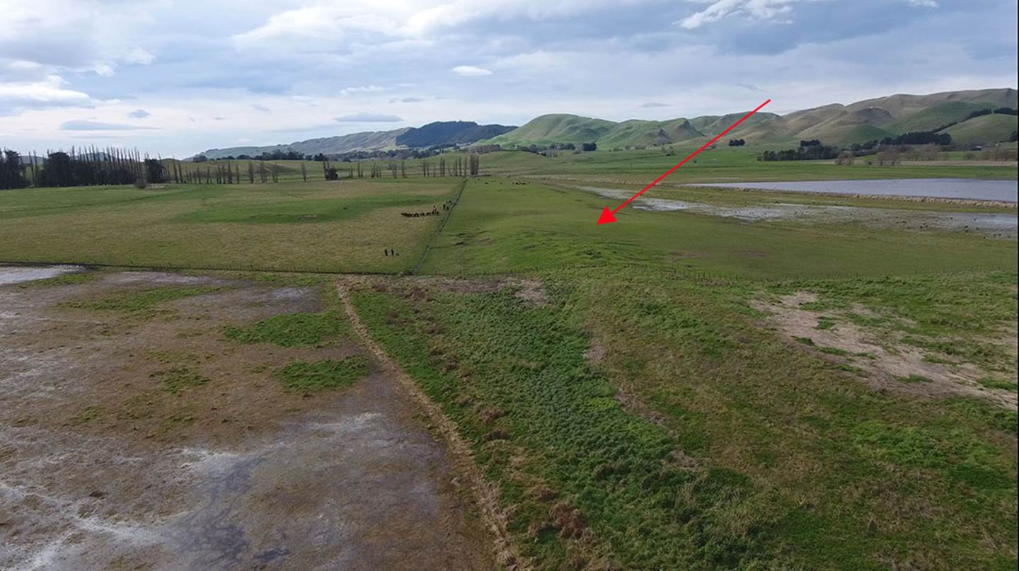
The heavily rutted and rumpled surface of Site 4, dotted with holes and lengthy depressions after half a century of abandonment. Price and his colleagues filled in the excavations at the termination of work in order to preserve features, but multiple scars remain these 50-years on. The centre-hump coordinates of this site are: 39° 46’ 33.63” S 176° 42’ 54.90” E It is on the farm of Mr. David Buddo.
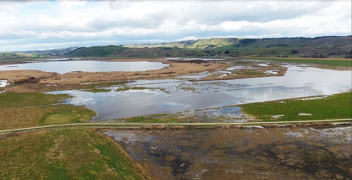
Photo taken from immediately above Site 4, showing its proximity to the lake waters and central island.
Concerning this strip of raised land at the northern end of the lake, Price wrote:
INTRODUCTION
Prior to the original drainage in 1931 the main body of water from Poukawa Lake had reached the outfall via two natural channels which passed through very extensive areas of dense high raupo. These waterways were wide and shallow with reasonably good footing and afforded excellent feeding grounds for many types of birds. The outfall its tributaries and the lake itself provided ideal conditions for the development of the Hyridella and other smaller types of freshwater shellfish, also freshwater fish and crayfish common to the North Island of New Zealand. The sites, N141/1 and N141/2, which are being investigated at present are situated at the north end of the old Poukawa Lakebed just inside the outfall, a short distance to the west of the present drainage channel. (Price 1963: 169) In view of the possible archaeological associations of the site, all excavating has been controlled and proper records kept from the first.
SUMMARY OF ALL WORK CARRIED OUT AT N141/1 from October 6th, 1962, to December 26th, 1964.
The site has been divided into three parts for convenience in working:
1. The Stream Bed: This is the dry bed of an old stream meander; the stream having been drained into the present drainage channel.
2. The Stream Bank: This is a strip of land, 2 – 3 ft. higher than the bed, which lies at the base of the headland. It is a gentle rising slope from 12 ft. to 30 ft. across and about 335 ft. in length.
3. The Headland: This is a low flat grass covered area some 10 ft. higher than the stream bed. A small shallow depression which proved to be an oven (or fireplace) was the only surface indication of occupation.
The three parts have been investigated separately and the work of the immediate future is to correlate the findings of each part.
THE STREAM BED:
Section of a 9 x 9 ft., 7 ft. 10 in. deep test square …..
Layer (1) 6ins. Brown peat. No timber.
“ (2) 2 ins. Course pumice mixed with peat. No timber.
“ (3) 4ins dark peat. No timber.
“ (4) 2 ins. fine white pumice. No timber.
“ (5) 25 ins. dark reddish cracked peat (sedimentary) No timber. Moa vertebra.
“ (6) 6 ins, almost pure deposit of hyridella, a few twigs.
“ (7) 8ins. yellow brown decayed matter with hyridella.
Layer (8) fine shells and small branch wood. Whole hyridella scattered.
“ (9) 12 ins. peat with fine shells and hyridella.
“ (10) 4 ins. pure deposit fine shells some hyridella. No timber.
“ (11) 18 ins. silty peat, small wood and hyridella. 5 giant swan bones.
“ (12) Base – blue pug.
A distance of 65 ft. of the stream bed has been excavated, a total of 804 square feet to date. The following were found: -
44 broken moa bones |
33 bones of other extinct birds |
70 unbroken moa bones |
72 unbroken bones, extinct birds |
72 gizzard stones |
1 split slab of totara cut in half |
Only 4 broken moa bones were found in layer (2), a few in layer (6) and the majority imbedded in or resting on layer (5). The split slab of wood was imbedded in layer (6) immediately under the edge of the stream bank.
THE STREAM BANK:
Section of test square:
Layer (1) 6 ins. peaty soil
“ (2) 3 ins. coarse pumice, peat, pumice stones.
“ (3) 2 ins. peat. No timber.
“ (4) 1 ins. fine white pumice.
“ (5) 5 ins. peat, wood, matai seeds.
“ (6) 6 ins. brown stained soil with wood.
“ (7) 6 ins. stained pug.
“ (8) Base pug.
The following were excavated from 1,760 square ft. of bank squares:-
161 broken moa bones |
1,203 broken bones of other extinct birds |
183 unbroken moa bones |
565 unbroken bones of other extinct birds |
430 gizzard stones |
|
The great majority of the moa bones were found along the edge of two middens; most of the bones found in the stream bed were spill over from the midden which came right to the edge of the bank. 95% of the bones came from below the two pumice bands. At the foot of the headland some fire blackened broken stones together with a sandstone file and finely grooved sandstone were found in the midden. A further midden at the north extremity of the excavation contained several types of moa some of the bones of which were possibly worked, together with badly smashed pelican bones, oven stones and an obsidian cutter. When the squares at the foot of the south-west face of the headland were excavated, a well-marked layer of redeposited subsoil appeared. This had clearly come from the higher part of the headland, but its nature and extent had not been elucidated.
THE HEADLAND
The headland has been divided into three faces for convenience, the south-west, the south and the south-east.
The south-west face:
880 square feet have been excavated and four fire pits found, two containing fragments of moa bone, several pieces of totara wood were found 2 inches below the surface. A total of 547 pieces of stone were found. (The nearest local source of stone is a limestone outcrop a mile or so from the site). There were 241 fire stones of local origin, 160 broken hard non-local stones, 81 stone flakes (heat fractured), 25 flint flakes, 27 jasperoid stones, 7 sandstones, 2 unbroken hard stones 4 obsidian flakes and 262 broken pieces of moa bone.
The south face:
756 square feet in extent, has not yet been excavated.
The south-east face:
1,788 square feet, of which 352 sq., ft. have been excavated. A large hyridella midden was found below the crest of the face, resting on a previously occupied area. Moa bones were found on the base in association with shallow scoops and post holes, both these lying above the top pumice band. Pieces of worked totara wood some two inches below the surface, scattered over a wide area, associated with a few stones and one obsidian flake. From the midden and below were found: 820 fire stones of local origin, 702 broken stones (non-local), 34 broken soft white stones (flint core casings), 15 pieces of worked totara wood, 1 flint stone, 1 obsidian flake, 10 pieces broken moa bone and 6 broken extinct bird bones.
SUMMARY RESULTS FROM N141/1:
Signs of human habitation have been found on the headland, and there appears to have been at least three periods of occupation. The link between these occupations and the extensive middens on the stream bank and in the stream bed has not yet been clarified, but it seems clear that the first, and possibly the second, occupations were associated with extinct bird hunting and with extensive middens at the base of the headland. There are indications that the two early occupations were separated from the later one by pumice bands. The stone artefacts recovered are sparsely scattered throughout the site and number about thirty: these are primitive flakes of flint, complete with sandstone files and rubbers.
A total of 2,373 broken and unbroken bones of extinct birds were found, 95% below the fine pumice layer (4). 458 broken and unbroken moa bones were also recovered – all but 4 below layer (4).
The extinct birds comprise a wide range, some very rare. No bones of the swamp hen common in the district today have been found at either site. The remains of the extinct giant swan and extinct ducks dominate the collection. The moa bones represent a wide range from Dinornis giganteas, D. hercules, D. gazella, two D. immatures and several types of smaller mature and immature moas.
The chief objective of the early hunters appears to have been the giant swan and smaller birds and whatever moas were handy together with hyridella shellfish. No moa eggshell was found. Parts of two tuataras were recovered from the base of the excavation.
Te Papa Museum, Wellington, New Zealand holds 21,714 bird bone and fossil vertebrate artefacts from the archaeological digs of Treaton Russell Price and his team at Poukawa.
On the 23rd of January 1967 Russell Price wrote in the above report:
‘The site has been set out in 10 ft squares with a foot-wide baulk left in between each square. Each square has been trowelled and great care has been taken to see that all material recovered has been recorded in all the various layers for each square. Three books for records are in constant use together with a grid plan and location plan. Photos and slides are available and a carefully drawn cross-section illustrating all the various layers encountered in the excavation will be sent with the artefacts when site is finished.’
Here's a sample of a two-page spread from the bone book. Other large field books listed artefacts found.
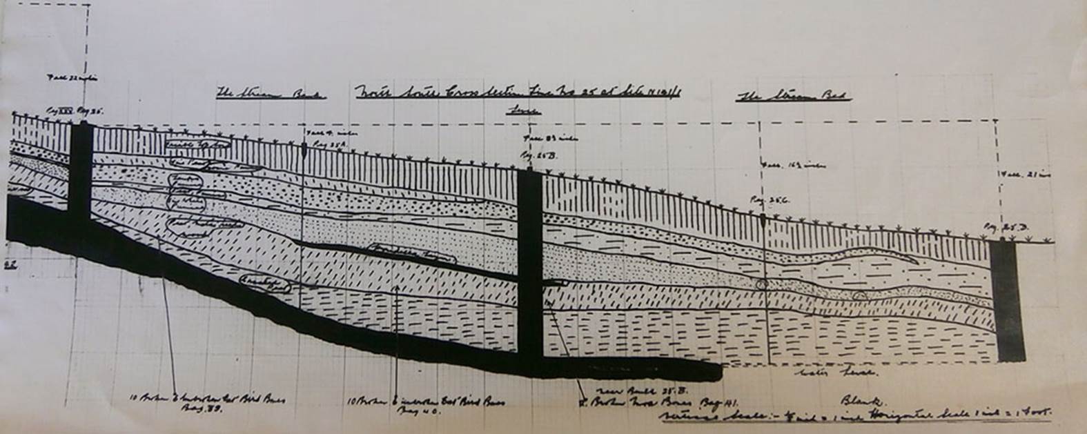
One part of a cross-section profile drawing Russell Price did at NZAA site No. N141/1. The site is divided by vertical lines into 3 sections: Left: The Stream Bank. Middle: Section declining towards the stream bed. Right: Stream Bed.
To the left of the picture, Price labels the layers as (starting from the top) Friable topsoil; Fine peat, some pumice; Taupo pumice; peat mixed; fine white pumice; Peat, matai seeds, wood; cracked peat, below which is the water table
At the bottom of the picture, Price writes a series of captions, with arrows. From left: 10 broken, 6 unbroken ext. [extinct] bird bones. Bag 39.
Further towards the middle the arrowed caption reads: 10 broken, 8 unbroken ext. bird bones, Bag 40. He also depicts hyridella shells just below the fine white pumice layer.
The next arrowed caption to the right reads: Near bones 25.B, ? broken moa bones. Bag 41.
Price lists his vertical scale as 1/8th inch = 1 inch. His horizonal scale is: 1 inch = 1 foot.
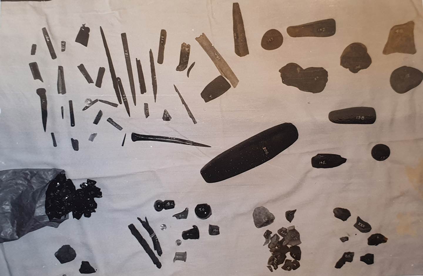
Many artefacts, fabricated or used for a wide range of human endeavours, hunting, sewing, scraping, pounding, sharpening, cutting, grinding, drilling or simply as ornamentation were located at the several dig sites across the Poukawa Valley. With a large number of these artefacts or objects, associated directly to humans, having been found beneath the Taupo and Waimihia ash bands, there was conclusive proof of a human presence at Poukawa spanning over 7100-years.
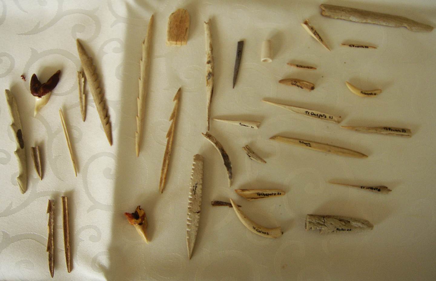
Similar ancient serrated-edge barbs, needles and boring tools from the South Island of New Zealand, home to many of the pre-Maori Moa-hunter tribes that had flourished in New Zealand since remote antiquity. The above items are in a private collection.