POUKAWA REVISITED … The History Changing, Archaeological Work of Treaton Russell Price (1901 – 1986)
'In the course of normal science, it may happen that anomalies
begin to accumulate. Some of these may be set aside for future research. Some
may be dismissed as irrelevant. But if a sufficient number of anomalies
accumulates, anomalies which resist solution by the paradigm or incorporation
into it, a crisis develops. As the crisis intensifies, scientists begin to
offer and promote new paradigms capable of accommodating the anomalies. If one
of these paradigms attracts the attention of a sufficient number of members of
the research community, a scientific revolution takes place. The research
community learns to see things in a different way. It develops a new set of
methods and concerns.
Kuhn points out that unless there is a recognizable crisis, provoked by an
accumulation of crucial anomalies, there will be no movement to a new paradigm.
The first step toward movement to a new paradigm is thus recognition of
anomalies, of counter instances to the current paradigm'. (See Forbidden Archaeology by Michael Cremo).
One of the unsung heroes of New Zealand was a surveyor / farmer / amateur-archaeologist, T Russell Price, who devoted some 25-years, off & on, to very substantial archaeological digs at Poukawa, Hawkes Bay, New Zealand.
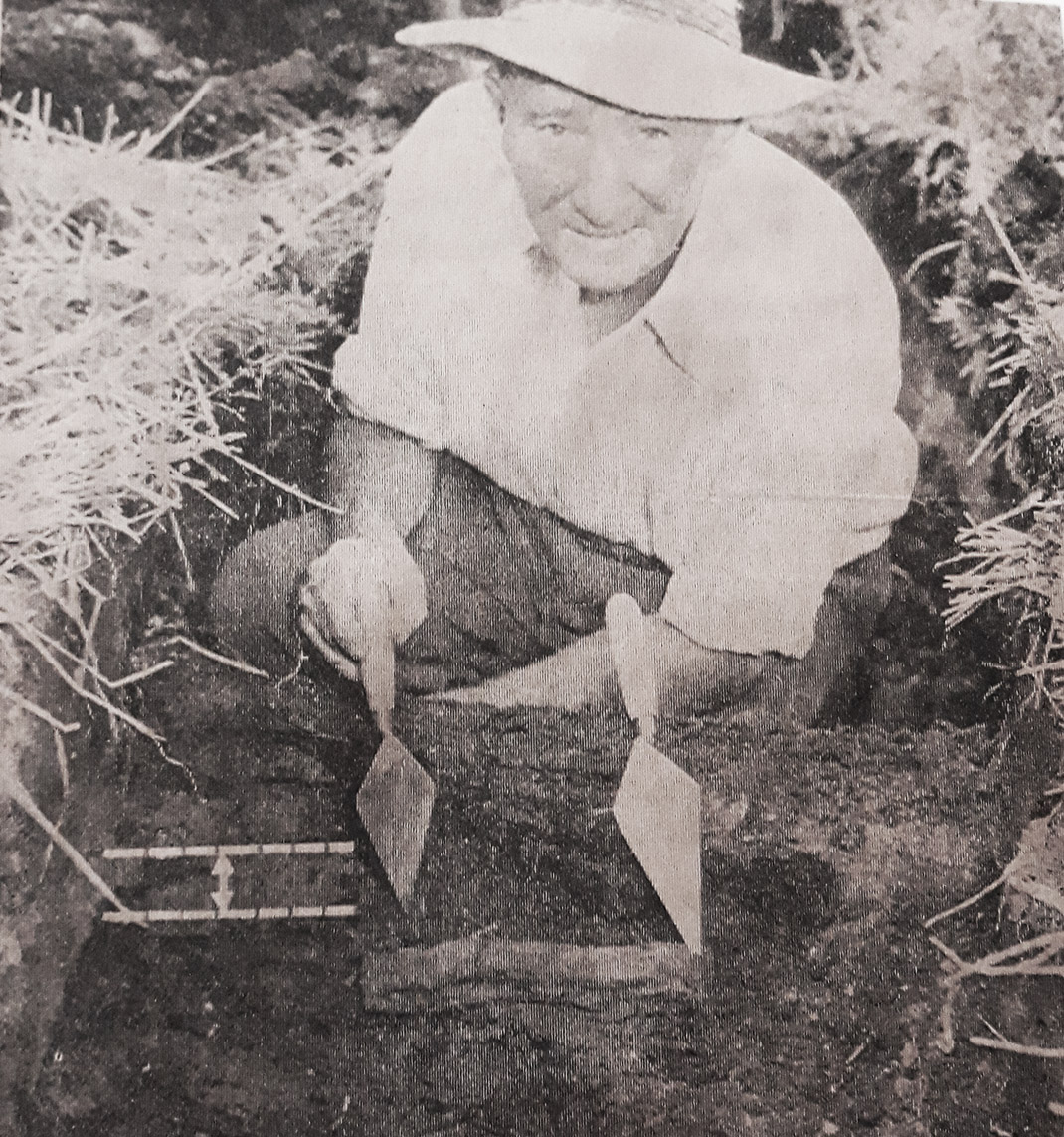
Treaton Russell Price down in one of his excavations, shows his trowells pointing to an obviously cut piece of wood lying in situ below the Taupo tephra (pumice or volcanic ash) from the 186 AD volcanic explosion of Taupo. The dotted line indicates the Taupo tephra layer. Price and his team, over decades of careful archaeological digging, found undeniable proof of ancient human occupation spanning 7000-years. This was subsequently verified by C14 carbon dating testing by the DSIR lab, Lower Hutt, Wellington district, as well as comprehensive scientific involvement by leading New Zealand archaeologists, geologists and pedologists.
Russell first became involved at Poukawa as a surveyor in the year 1930, responsible for building a canal trench for the outflow drainage of Lake Poukawa. A giant dragline excavator was brought in to make the channel cut along the surveying line that Price had marked through the sodden raupo swampland. Prior to this successful endeavour there had been frequent flooding of surrounding farmland following torrential rains. The new canal drain at the northern end of the lake was completed in 1931 and enlarged 30-years later in 1961. The partial drainage of the lake brought 3500-acres of former lakebed land into pasture.
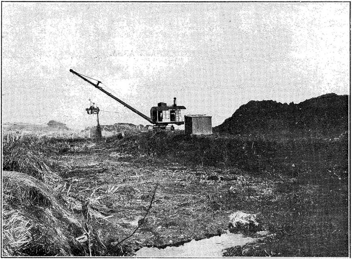
A typical vintage dragline of the (circa) 1920s – 30s creating a drainage channel through wetlands of the Kaikokopu Stream, Waihi, Tauranga District, New Zealand. The "steam grab" dredging machine used on the Poukawa canal was a Priestman brand machine, chunky metal parts of which still languish on Bill Buddo's farm where they were abandoned at the end of the job.
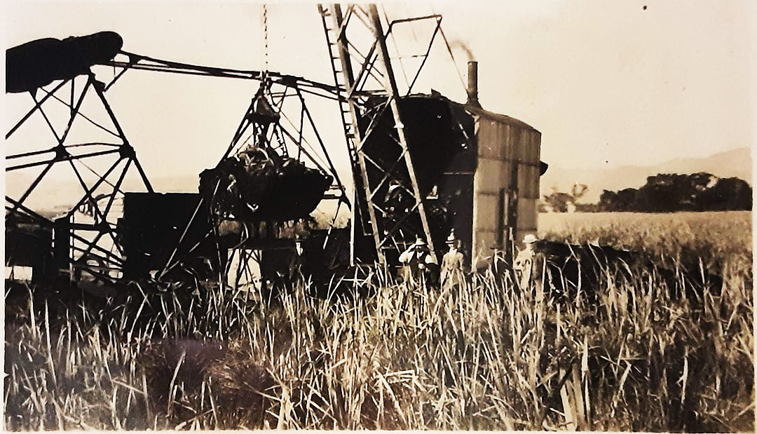
The Priestman dredge amidst the tall raupo-papyrus plant of Lake Poukawa's soggy shoreline. The barge upon which the dredge sits is fully obscured by the high raupo and a bucket-load of lake bottom mud hangs from the derrick boom. At the termination of the 1931 canal excavations, the long boom became the under- structure of a bridge on the farm presently owned by David Buddo.
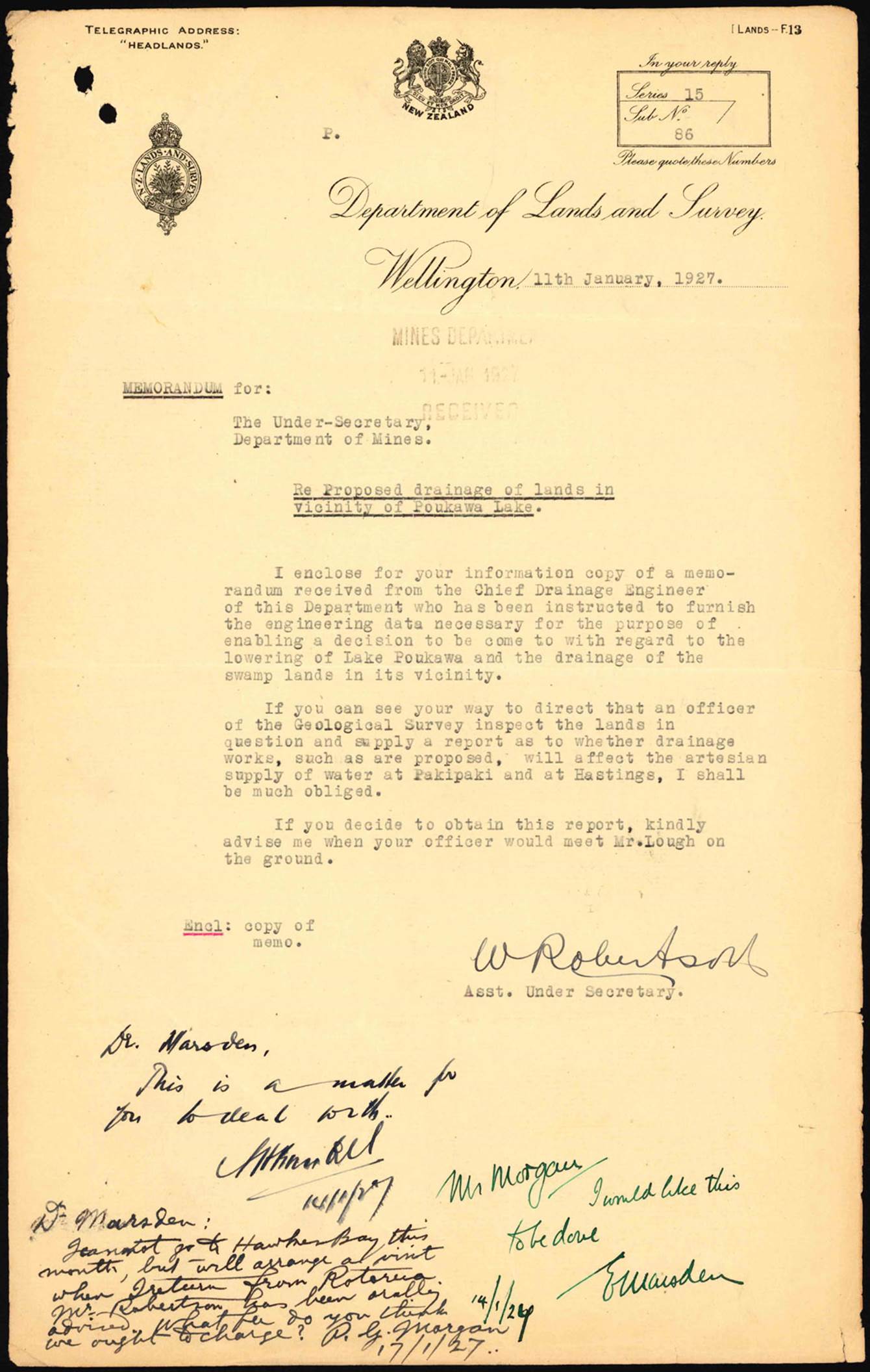
In January 1927 the Department of Lands and Survey were asking for feasibility studies to be carried out, leading to partial drainage of Lake Poukawa. Work got underway in 1930.
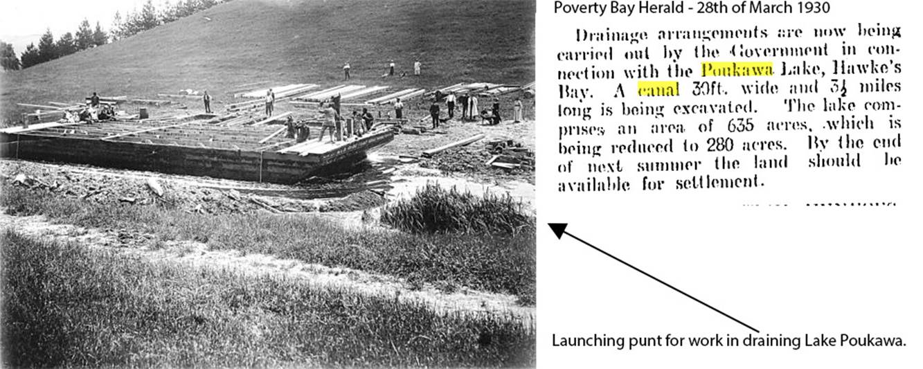
For the large-scale Poukawa canal project, the steam-grab excavating machine had to sit atop a floating barge that moved forwards as the new canal grew in length.
https://paperspast.natlib.govt.nz/newspapers/NZH19300401.2.163?query=Poukawa%20canal&snippet=true
The canal dug in 1930-31 was to assist the outflow of water from Lake Poukawa and with 6-feet of freeboard could quickly expel surplus water build up after torrential rains. Interestingly, in February 1931 there was a massive earthquake in Napier, the epicentre of which was 50 kilometres (31-miles) to the NNE, but the Poukawa Valley was, by-and-large unaffected, with only minor damage to the developing drainage system. Some brick chimneys on houses, at the northern reaches of the lake, tumbled and some farm fences further towards Napier got a few inches out of line, bur the immediate vicinity of Poukawa Lake saw no serious collateral damage, although there were some slips on the banks of the newly dug canal and, in the swamp portion of the excavation, the bottom rose several feet. This relatively minor damage was to be rectified the following summer.
‘No horizontal movement was recorded on the northeast trending rupture northeast of Poukawa, but at Bridge Pa, a 0.2 m left-lateral displacement of a fence was recorded near the southwestern end of a northeast-trending pressure ridge that was upthrown to the southeast (Henderson 1933, p. 59). A fence crossing the surface rupture 1km north was, however, undisplaced. Henderson (1933, p. 56) described a locality southeast of Poukawa Railway Station:-"a series of short echeloned tears in the turf displaces a fence 8 inches [0.2 m] horizontally; there is no apparent vertical movement.’ (See: https://www.tandfonline.com/doi/pdf/10.1080/00288306.1990.10425689?needAccess=true )
As the new canal system excavations proceeded to the base of a hill ENE of the lake a very strange anomaly was revealed. With the dragline cutting its way through the stand of raupo swamp plant, a section of the mud was found to contain many sets of long leg bones and feet of the now extinct giant Moa bird. Surveyor Russell Price found this to be quite mysterious, as he could see no evidence of the other skeletal parts of the stuck-in-the-mud birds. This triggered surveyor, Russell Price’s curiosity, followed by a long period of bewilderment, which lingered with him for years thereafter.
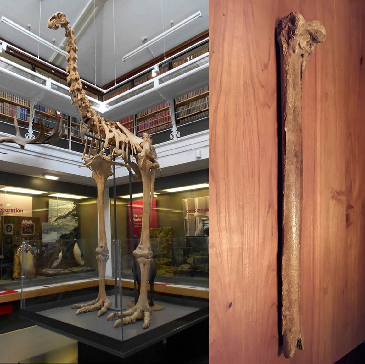
Left: The skeleton of a giant Moa, some species of which stood 12-feet (3.7 metres) high. Right: A femur leg bone, one of the hundreds of Moa bone remains located on the Buddo Farm, Poukawa, New Zealand where Russel Price commenced archaeological digs in 1956.
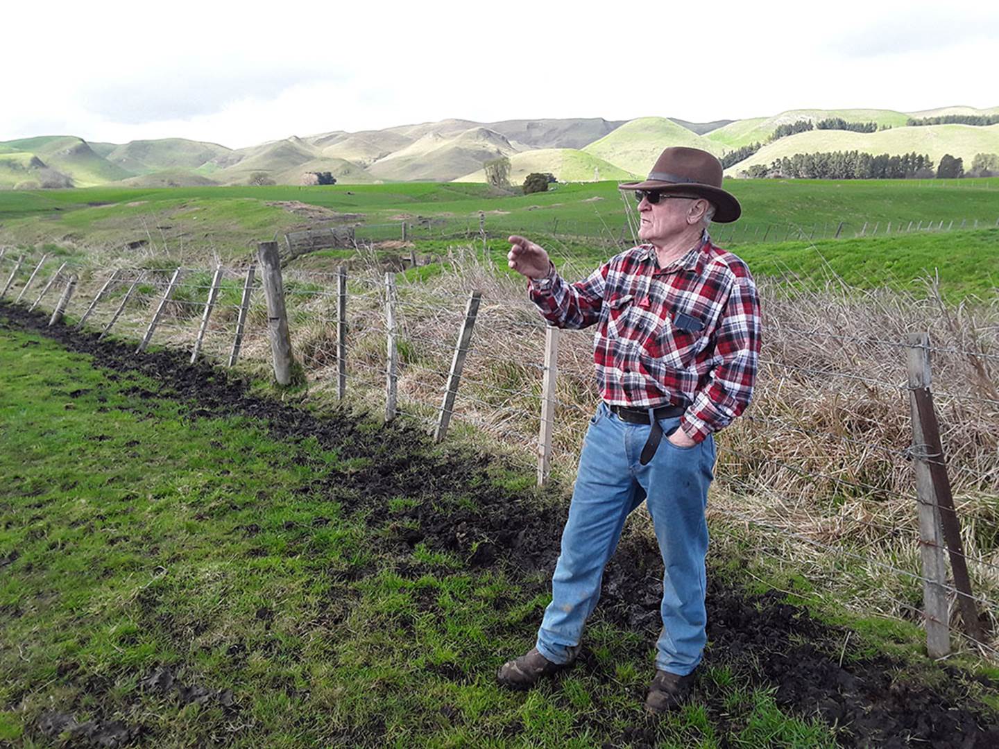
Farmer Bill Buddo, worked extensively with Russell Price on archaeological digs around the Buddo farm when in his formative years and teens, as did his cousins, along with a dedicated team of adult volunteers and credentialed scientists.
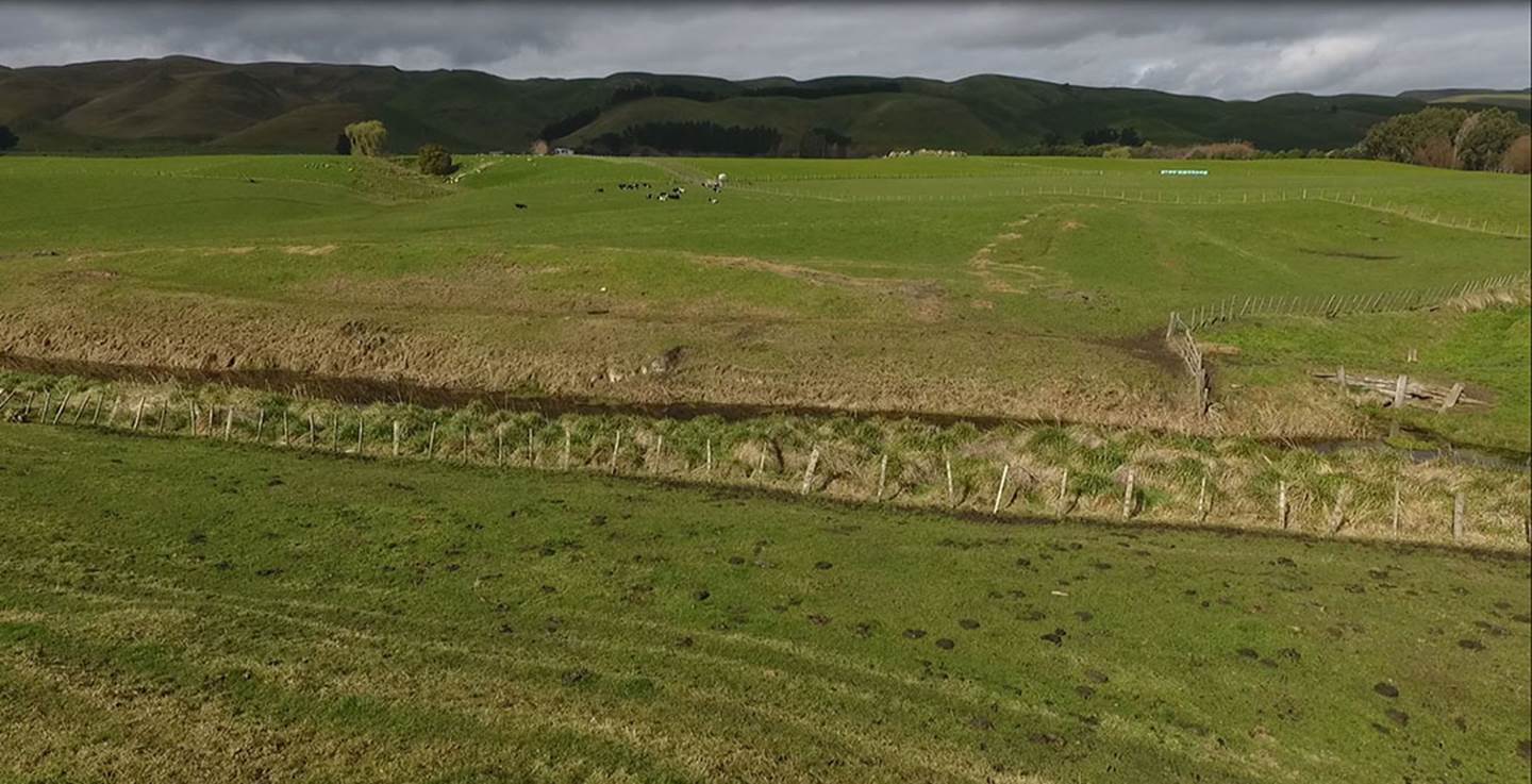
Bill stands in front of the canal trench where Russell Price first became aware of multiple leg bones embedded vertically, in the mud and, in the background are distant hills and valleys where the faint depressions of well-worn Moa trackways can be seen to this very day.
Russell later recounted to Bill how, in 1930, he leaned on the self-same fence and tried to work out why there were only leg bones, but no signs of the torso, neck vertebrae and skull of the birds. After much contemplation he concluded that the culprit behind this anomaly was humans … Moa hunters!
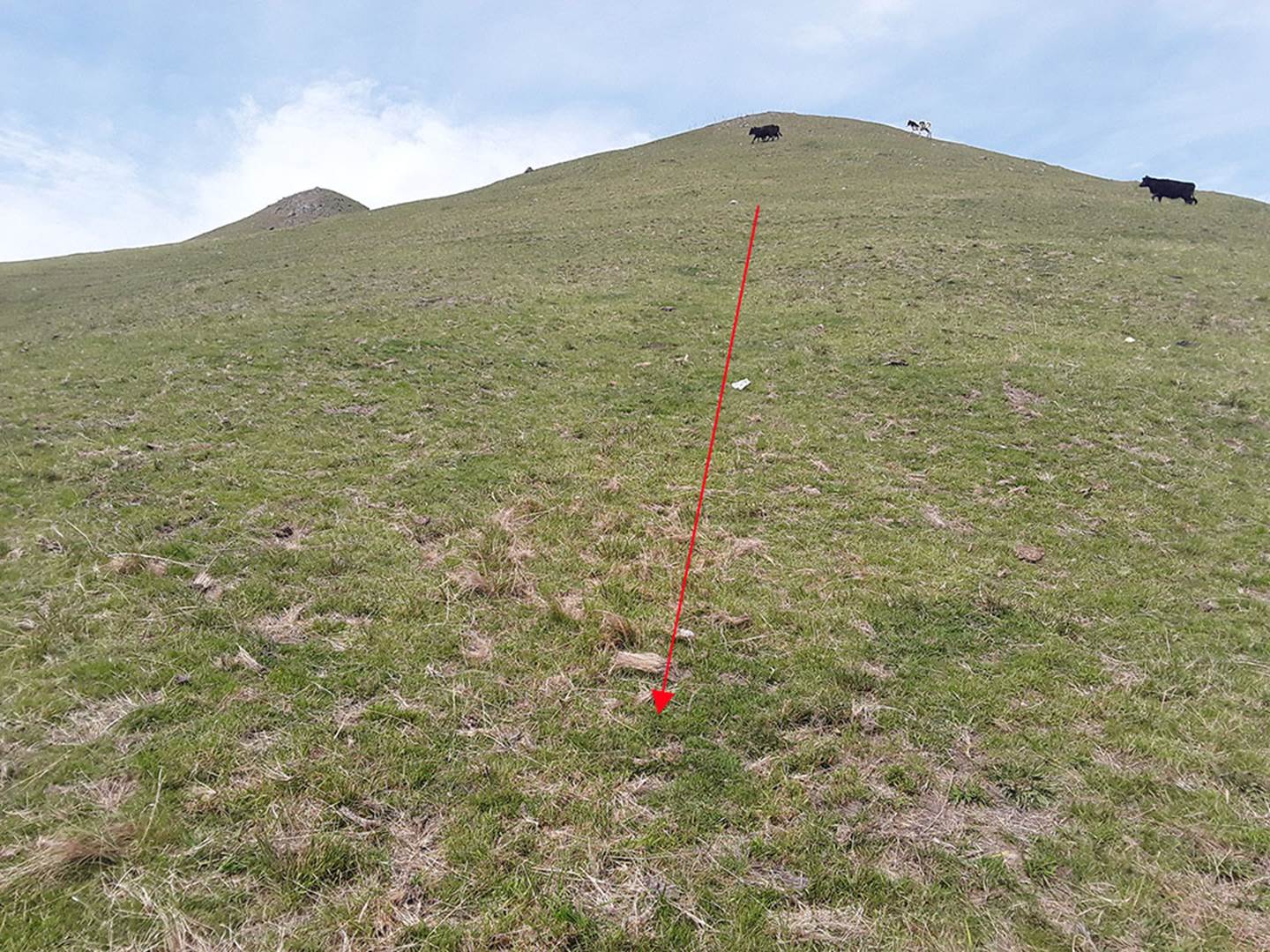
Over 50 or 60-years ago the well-worn Moa tracks, at various points around the valley, were very prominent and easily seen, especially in mid-summer when the tracks showed up greener than the browner grass to the sides. In this photo the Moa track depression can still be seen, albeit faintly. Whereas cattle tend to make almost horizontal-diagonally circumnavigating tracks down and around steep hillsides, the obviously sure-footed Moa birds would walk paths on more inclined angles right down the face.
Russell price was a very practical, logical man who, as a professional surveyor, did his work and drew his charts with meticulous, careful detail. As a farmer for many years beyond 1930 - 31 (after he had participated in the Poukawa canal construction scheme) he was a keen observer of animals and noted the way they would move across flat terrain, negotiate hillsides or circumnavigate obstacles like wetlands. Drawing upon all this combined experience he returned frequently, over the years, to look closely at the spot where the solitary Moa leg bones had been found. He studied the harder ground contours adjacent and, from this, was able to see the natural pathways the giant Moa birds would have followed to the base of the hill. He could readily see where the Moa hunters would have secreted themselves in order to, at the precise moment, burst forth, bellowing to scare the hapless, giant birds sideways and down into the soft mud, thus rendering them stuck immobile and helpless.
The hunters would then chop through the legs of the stranded birds and drag the torso up onto the hard ground for plucking, cooking and eating. It was evident that a section of raised land nearby, but sufficiently distant to be inconspicuous to the view of birds on the trackway, was a Moa hunter campsite, complete with cooking pits (found in later excavations).
THE EXTENSIVE EXCAVATIONS BEGIN
As Russell approached retirement, he wanted to devote far more time to trying to answer outstanding questions related to New Zealand’s history of human occupation. Maori oral traditions and much other physical evidence would suggest that the country had been inhabited for a very long period before the coming of the Polynesian-Melanesian Maori in circa 1300 AD. Many scholarly works by early historians and anthropologists lent credence to this conclusion and multiple books were available on the library shelves containing oral histories of the learned Maori tohunga (priests) and elders on this subject matter. Seemingly, every iwi (Maori tribe) across New Zealand had names, physical descriptions and histories of their encounters with the earlier inhabitants and Maori had harboured no reluctance to withhold these oral traditions, recounting them openly, often in graphic detail, to genuine enquirers.
Like all New Zealanders of his time, Russell Price had access to such works as the 1830s observations of individuals like Joel Samuel Polack (Manners & Customs of the New Zealanders … Vols. 1 & 2) or John MacMillan Brown’s 1920s (Maori And Polynesian: Their Origin, History And Culture). Added to Brown’s scholarly works was Problems And Peoples Of The Pacific, also in 2 volumes. By 1952 Thor Heyerdahl’s massive tome, American Indians in the Pacific had become available, showing layer upon layer of compelling proof linking the Pacific region’s cultural, artefact, flora and some fauna directly to ancient South America (and stemming from a remote-antiquity, pre-Polynesian epoch).
As Russell commenced his digs at Poukawa in 1956, archaeological investigations in New Zealand were at their zenith and it was an exciting, golden age of discovery. This persisted through to the early 1970s, after which time openness gave way to cultural-Marxist dabbling, disruption, censorship and growing interference.
None of these problems of 25-years hence raised their ugly head as Russell Price, with expectation, optimism and enthusiasm, commenced his comprehensive assessment of the Poukawa landscape. In the course of the 1930 - 31 building of the canal he’d noted how the newly cut drainage trench, where it traversed sections of higher ground, showed two stratifications of undisturbed tephra ash fallouts from massive volcanic explosions in antiquity. These explosions gave very significant and convenient time signatures, as the eruption dates, leading to fallout of both tephra ash bands, were known, one in circa 186 AD (Taupo ash fall … 1764-years prior to 1950 and Waimihia ash fall … circa 3440-years prior to 1950).
Even without the expensive undertaking of carbon dating of organic materials found beneath the ash band stratifications, one could still calculate the approximate date they came to rest there. If any of the organic matter or artefacts beneath the layers showed signs of human activity in their placement, then that would prove human occupation long before the circa 1300 AD Polynesian-Melanesian epoch.
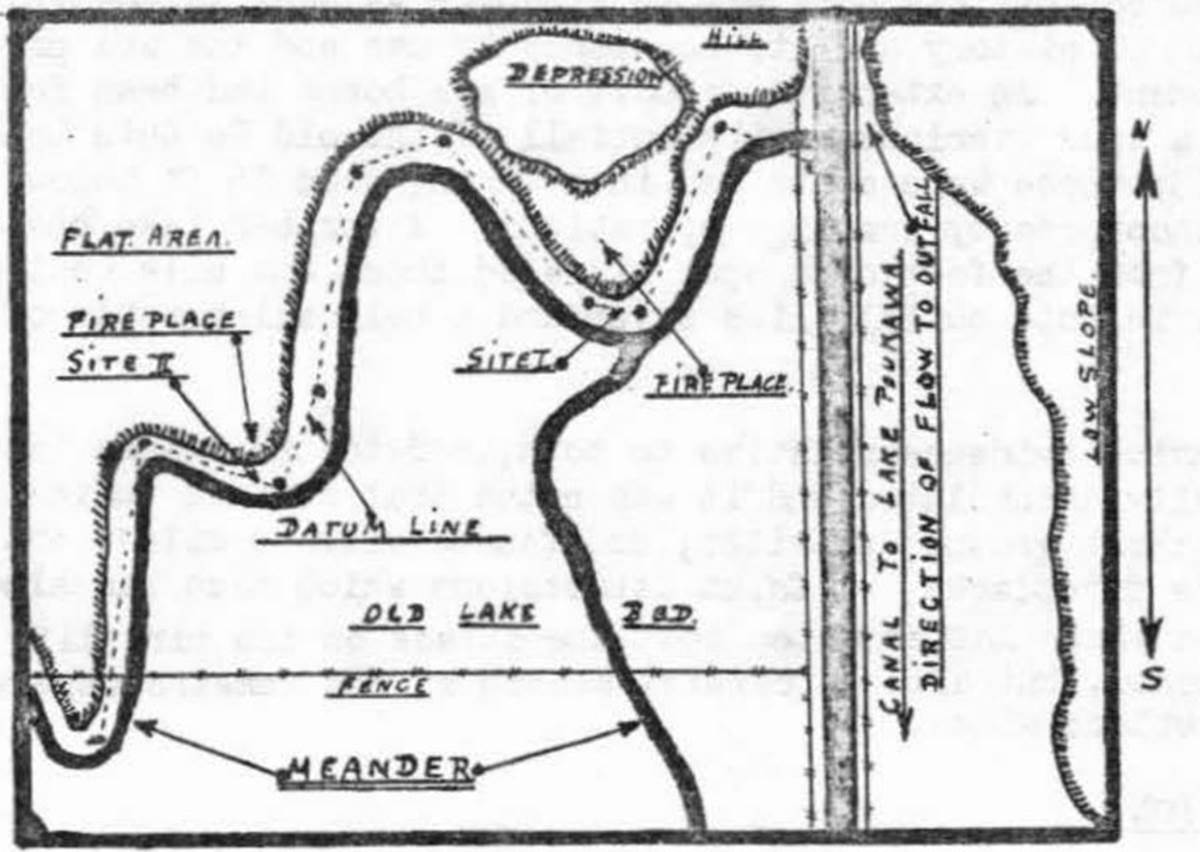
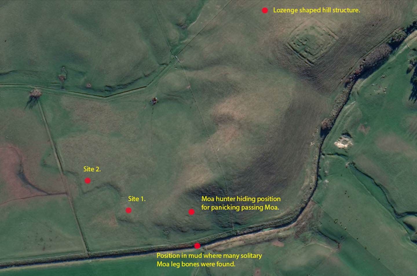
In his 1963 report for the New Zealand Archaeological Association, Russell Price drew this plan of sites 1 & 2 of his exploratory digs. In the upper central region of the plan he shows a raised hump that shallow, outflowing lake water once meandered around, almost forming an island. Russell referred to this spot as a Moa hunter campsite and, during excavations, found a fireplace or cooking oven on the hump (Site I). This site was far enough away from the Moa migratory track that it could not be seen by the passing birds. From this hump, the bones left over from cooked & eaten Moa were thrown into the adjacent lake immediately in front of the fire pit, forming a midden. Beyond the humped-up campsite was a wide depression in the ground at the toe of the hill. A little further away on higher ground the hunters could secrete themselves, ready to spring forth and frighten the passing birds into the muddy bog.
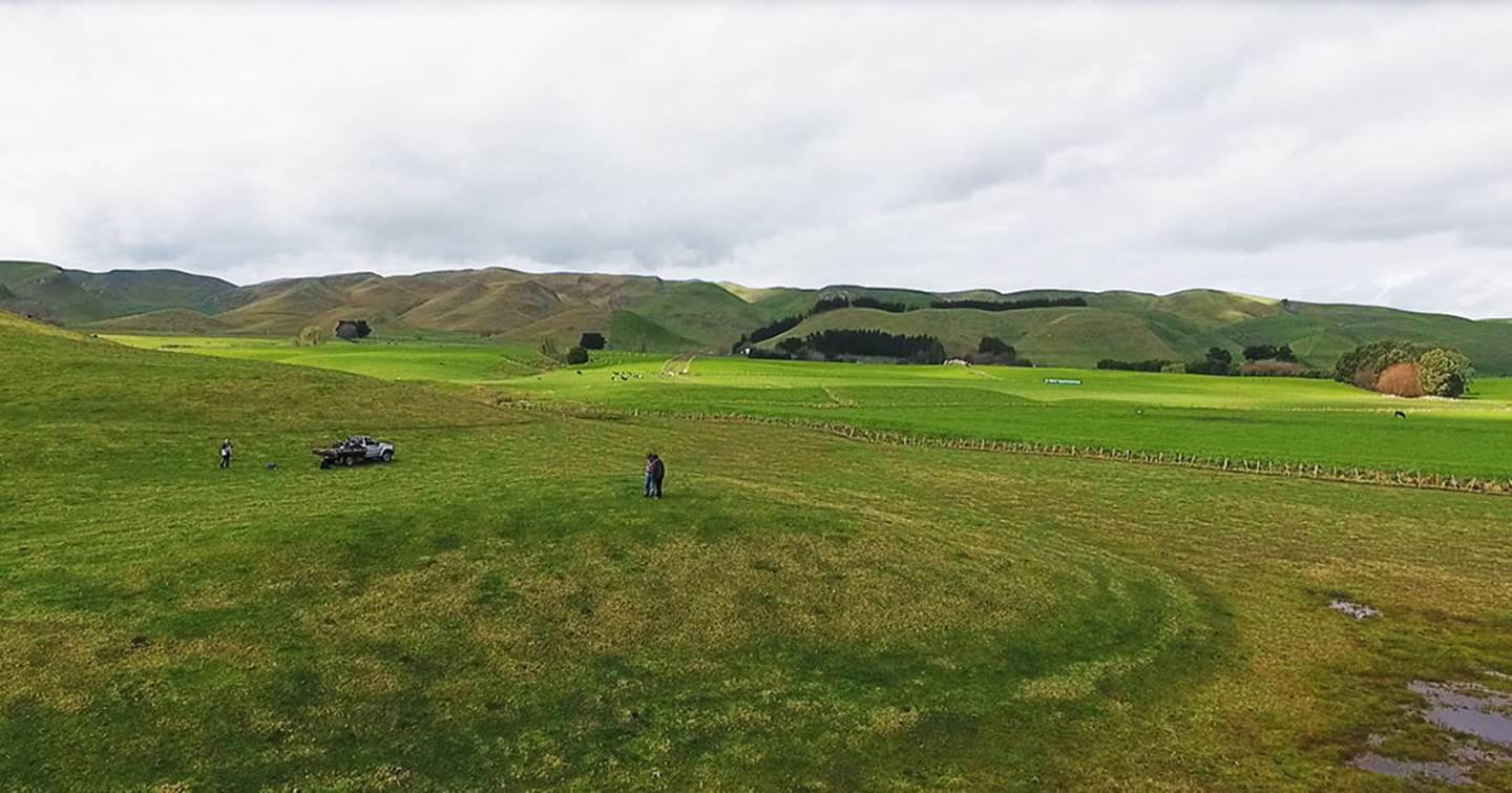
Farmer Bill Buddo and the author stand atop the Moa hunter campsite hump (Site 1) where birds were cooked and eaten. The farm truck sits in the depression adjacent to the base of the hill where the Moa hunters lay in wait for the birds passing along the track. The lighter or sunnier high ground in the middle section of the picture shows where birds crossed the valley floor from the range of hills on the skyline.
This is the approximate vantage point, on elevated ground, where Price concluded the Moa hunters would have secreted themselves for scaring passing birds on the track down into the bog. The Moa tracks, still visible in the 1950s -60s would have followed substantially firm ground and cross-over points of the lake outflow, whereas this bog location served the repetitive purpose of trapping the startled and panicked birds very effectively, as evidenced by the number of huge leg bones in situ.
On Russell Price’s drawn map, he shows yet another fire pit at site II, not far removed from site I, where birds were cooked and eaten.
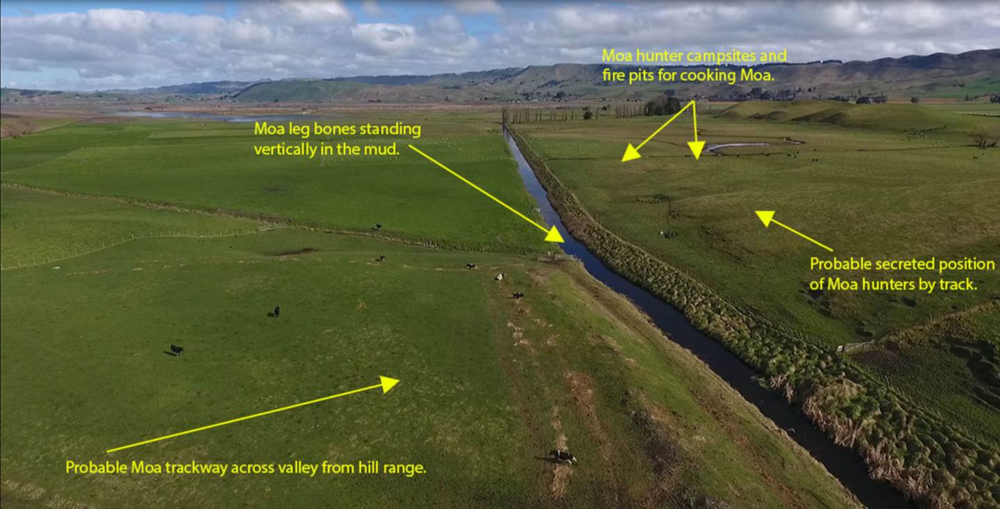
A picture of the Poukawa Lake drainage canal, with the lake shown in the background. Arrows point to the significant spots along the ancient Moa track where the giant birds were captured, killed, cooked and eaten. Although no Moa bones or those of other birds were to be found in the firepits, such fragments were found as cast away debris in front of the firepits, which were undoubtedly given a good cleanout before frequent reuse. The coordinates for dig site 1 are:
39° 46’ 18.09” S 176° 43’ 46.70” E The coordinates for dig site 2 are: 39° 46’ 16.60” S 176° 43’ 43.53” E
The lozenge
shaped hillfort shown orientates onto the 4 primary points of the compass, with
corners pointing to north, south, east and west. The due north point orientates
onto purpose-placed limestone boulders situated on a high ridgeline 12320-feet
away (2![]() miles or 3
miles or 3![]() Sites 1 & 2 shown above had fire pits for cooking. When Price commenced his first digs
on Site I he was probably unaware of the fact that he would one day have access
to the carbon dating technologies of the DSIR laboratory, Lower Hutt. In lieu
of such advanced scientific technologies being placed at his disposal he had
the tephra ash bands from volcanic explosions bracketing artefacts found into
decipherable time capsules. He quickly conceived of a modus operandi that
focused on the ancient ash showers that had occurred over a millennium or
several millenniums before Maori found these shores.
Sites 1 & 2 shown above had fire pits for cooking. When Price commenced his first digs
on Site I he was probably unaware of the fact that he would one day have access
to the carbon dating technologies of the DSIR laboratory, Lower Hutt. In lieu
of such advanced scientific technologies being placed at his disposal he had
the tephra ash bands from volcanic explosions bracketing artefacts found into
decipherable time capsules. He quickly conceived of a modus operandi that
focused on the ancient ash showers that had occurred over a millennium or
several millenniums before Maori found these shores.
Before commencing his formal digs, Price had a talk with the local Maori elder and laid out his strategy or approach to archaeological investigations. He would excavate down to the top of the 186 AD ash band layer (volcanic pumice) and carefully clear it of all humus and debris. Anything previously found in the humus, or peat and ash mix, of the layers above the 186 AD pumice would be considered to contain potential residues from the Maori epoch of habitation. Price would then carefully inspect the ash band layer surface from the 186 AD fallout to ascertain that it was undisturbed, with no fissures or evidence of foreign content. It had to be purely airborne ash, composed of the grittier or heavier particles at the bottom of the band, reducing to talcum-powder-like material at the upper surface. Once the sealed integrity of the ash band was known and approved, he could excavate down through it with the firm conviction that any cooked and broken up Moa bones found, bearing the cut marks of obsidian knives etc., as well as any other manmade or utilised artefacts, had been deposited there and lain in situ from before the volcanic explosion of Taupo in circa 186 AD.
As Doctor Richard Holdaway stated in 1996, after falling foul with his peers for his heresy in finding kiore rat bones beneath Taupo tephra ash:
'… most archaeologists have never actually excavated through two feet of ash. It seals everything underneath it. You can see every last wormhole in it and you can see where there is damage to it. So, if something is underneath you know it was there before the ash fell...' (See: 'Listener' article: ‘Rat Revisionists', 7.12.96).
Holdaway’s discovery that the kiore rat had been in New Zealand for at least 1100-years before Maori arrived in 1300 AD was a most unwelcome find, as the little critter is a real landlubber that hates water and could only have arrived with humans.