SO, IS IT POSSIBLE THAT THE NEWPORT TOWER IS PRE-COLUMBIAN?
The possibility is certainly there and could be expanded upon if a proper, reliable survey of the structure became available to test mathematically.
It is claimed that the 1878 survey by George C. Mason has inaccuracies in it but this researcher has located no other source of measurements to show where these claimed discrepancies lie.
If the tower once acted as (was built to be) a mnemonic device and repository of navigational and cyclic astronomical codes, then the ground to sill and lintel heights of all windows will prove to be significant, as well as the square inch area values of the openings themselves. Every conspicuously in-built nook, cranny and apex will be coded and contain tutorials, which "Masters of the Craft" imparted to initiate students and explained in depth for the students to memorise by rote and repetition.
The tutorials would have included diameter codes being converted to circumference codes (for teaching navigational methods of positional plotting) and we can now speculate on what some of these might have been based upon the best, published external and internal measurements that are available.
Some writers are critical of the fact that the tower is slightly elliptical, but forget that many or most ancient stone circles were laid out deliberately to be slightly elliptical. The reason for that was to build in at least two diameter codes (generally running at 90-degrees to each other) which converted into 2 different, but highly important circumference codes.
One Internet resource states:
'Professor Alexander Thom, an expert in the field of archeo-astronomy, spent several decades studying stone circles in an attempt to decipher their meaning. He discovered that not all were perfect circles - some were egg-shaped others elliptical - but whatever the shape they all seemed to show remarkable geometric precision long before the Age of Pythagoras.'
A good example of this is the inner diameter of the Sarsen Circle at Stonehenge, which is 100' in one cross measure, but 100.8 feet @ 90-degrees opposed. Via the 100' diameter, a measurable circular distance of 314.16' is achieved and this circuit was obviously used for teaching several variations of PI used in navigational calculations.
There were several renditions of PI in ancient usage, depending upon the kind of calculation being made within a particular number family, progression or string. Some of these included 22/7ths (3.142857) or 1728/550ths (3.141818182), as well as 63/20ths (3.15). Another occasional variation was 25/8ths (3.125).
At Stonehenge the 100' diameter would also have been multiplied by 3.15 to achieve a (symbolic if not literal) circumference of 315' (half a Greek Stadia of 630' ... about 2500-years before there was a Greek civilisation). The latter emerging civilisations simply used the Weights, Measures & Volume standards of earlier civilisations.
Likewise at Stonehenge, the second internal cross-measure, as stated, was 100.8' and, under the literal navigational method encoded into the base perimeter dimensions of the Great Pyramid, 100.8' was 1-second of equatorial arc.
Therefore, two complete circumnavigations of the Great Pyramid @ 756' per side was 6048' (1-minute of arc) or 60 X 100.8'.
So, with this in mind, lets assess the "published" internal diameters of the "elliptical" Newport Tower in an effort to see if any possible diameter and circumference codes were deliberately in-built.

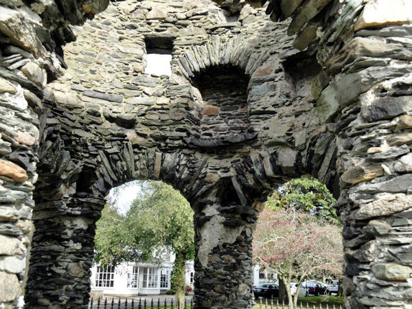
A view into the inner structure and its in-built recesses. If the Newport Tower was first conceived as a mnemonic device, then all heights, widths and depths of window and alcove features, as well as columns, etc., should have carried tutorials in their dimensions and volumes, as well as positions of placement.
From East to West the ID is reported to be 18' 4" , which is 220". This is an "11" family number and when voyaging by linear distances at sea using the "11" family mile of 5280' or league of 16500', the form of PI used to convert legs of travel to circumferences on a plotting circle was 1728/550ths or 3.141818182.
Therefore, 220" X 3.141818182 = 691.2".
Under the 24883.2-mile equatorial circumference, 1-degree of arc was 69.12-miles.
Using this diameter as the basis for a tutorial, an ancient "Master of the Craft" could have taught the entirety of the positional plotting method a navigator would have used, under the "11" navigational system, for dead-reckoning on the vast featureless oceans. When "11" series numbers are converted to a circumference, using PI @ 1728/550ths, the perimeter number derived is sexagesimal and divisible by 360-degrees.
By this means, a navigator could always keep track of the boats position, despite many zigzag course changes across the ley-line to the destination and be able to recalculate with each course change the angle and distance from the point of departure or onwards to the destination.
This infers that the navigator was experienced enough to calculate boat speed, the exact "11" based distance (say in leagues) traveled during a leg and the angle of tack (using the sun, moon or a bright star in the sky to provide a reference point for course changes and degree angle swings).
Additional aids, like sand-clocks, would have helped in providing very close guesstimates of distance traveled in a leg.
ANOTHER CROSS MEASURE.
From North to South internally, the Newport Tower is reported to be 18' 9" or 225".
Using PI at 3.15, this converts to a circumference of 708.75".
The Khafre Pyramid of Egypt was 15/16ths the length of the Great Pyramid. Therefore 756' ÷ 16 X 15 = 708.75'.
As mentioned, the lunar year is 354.375-days or 708.75 ÷ 2.
From this cross-measure, students in the first floor loft on a Winter's night, enjoying the warmth afforded by the fireplace, could listen intently to the Master of the Craft tutor and mathematically learn the entirety of the lunar cycles and their varied durations, from the lunar month & year to the fullness of the lunar nutation cycle of 6804-days.
Similarly, the 225" diameter could be used as a teaching tool related to how the 360-degree circle is divided into 1/4th, 8th and 1/6th parts, etc., with 22.5-degrees representing 1/16th of 360-degrees.
THE EXTERNAL DIAMETER MEASUREMENTS
Many of those proffering measurements for the Newport Tower, including architect George C. Mason in 1878, give an OD figure of 24' for its greatest diameter found on the edifice and this equates to 288". The diameter of the Aubrey Circle at Stonehenge was 288'.
Using PI @ 3.15 for tutorial purposes, the 24' diameter of the Newport Tower converts to a circumference of 75.6' or 907.2".
It must be remembered that one side length of the Great Pyramid is 756' or 9072" and that one side length equals 1/8th of 1-minute of the Earth's equatorial circumference under the "6&7" family of numbers combined, which configured the Earth as 12 X 12 X 12 X 12 X 1.2 miles of 5250' each.
As stated, by simply elongating the pyramid's length by 3" to 756.25', the entire "11" system of navigation, using the mile of 5280' and configuring the Earth's equatorial circumference to be 24750 such miles, could be taught.
From this singular circumference value alone on the Newport Tower, the entirety of the two most prominently used navigational systems of antiquity could be explained by seasoned and experienced Masters of the Craft to apprentices learning the navigational and cyclic astronomical arts.
Another diameter measurement said to run externally from NW to SE is 22' 2" or 266".
Although a diameter of 266.666666" (266 & 2/3rds ... 1/3rd of 800) would work well as a code to produce 840" or 70' on the circumference (using PI @ 3.15), it seems unlikely to have been the most important cross-measure code focused upon in this instance.
Admittedly, the mathematical progressions stemming from this circumference would produce excellent tutorials related to the equatorial size of the Earth and how it breaks down into degrees, minutes and seconds of arc.

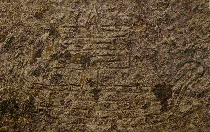
An ancient Continental-European or Mediterranean-type sailing ship appearing in a petroglyph and found in Michigan, USA. In this region of North America upwards of 500,000 tons of 99% pure copper were mined and then shipped to Europe and the Mediterranean during the Bronze Age. Ships of that ancient BC era would have been using the same navigational techniques that appear to be encoded into the dimensions of the Newport Tower and many of these selfsame techniques survived late into the Christian era.
However, it seems obligatory that a cross measure code of 264" (an "11" family number) would have been used at this point for teaching methods of positional plotting at sea when voyaging according to the mile of 5280' or league of 16500' (3.125-miles).
The sum of 2640' is half a mile.
The form of PI used for "11" family numbers such as this is 1728/550ths or 3.141818182. Under such circumstances, the 264" diameter would convert to a circumference of 829.44 and, in miles, this represents 1/30th of the Earth's 24883.2-mile circumference or 60-degrees of arc.
Another cross measurement from East to West is said to be 23' 3" or 279".
Although the value 279 is without significance, the value 280 would be highly significant. This is a "7" based diameter and the form of PI used to convert this to a full number, coded value is 22/7ths or 3.142857.
Therefore, 280 X 3.142857 = 880 (an "11" based number). This selfsame principle was used in navigation, where legs of travel were done according to Greek miles of 5250', which converts (using PI @ 22/7ths) to 16500' (or 1-English league of circumference).
The sum of 880' is 1/6th of a mile of 5280'.
As mentioned, by this mathematical method, accurate positional plotting at sea became possible for an experienced navigator keeping abreast of boat speed and angle of tack.
SUMMARY CONCLUSIONS.
It's hard to conceive of this structure as having been originally built as a windmill. The design appears to be inefficient and poorly-suited to support the heavy, swirling and vibrating blades, which would have, assuredly, weakened the structure in a relatively short time and caused an eventual collapse, although it was possibly adapted for use as a windmill from about the mid 1600's for an undetermined period.
It's also hard to conceive of a situation where newly arrived colonists, with no amenities and eking out the most basic existence at the starvation level would have had the surplus human resources available to build such a complex edifice during the first few decades of settlement. This becomes especially more clear in consideration of the meticulous surveying required to site the tower, such that its position was fixed to a hill summit marking true north and also to other hills marking solstice and equinox events, etc.
No record exists that speaks about the era of its construction and we are left to speculate that it was already a part of the scenery when the first American colonial immigrants arrived from Europe.
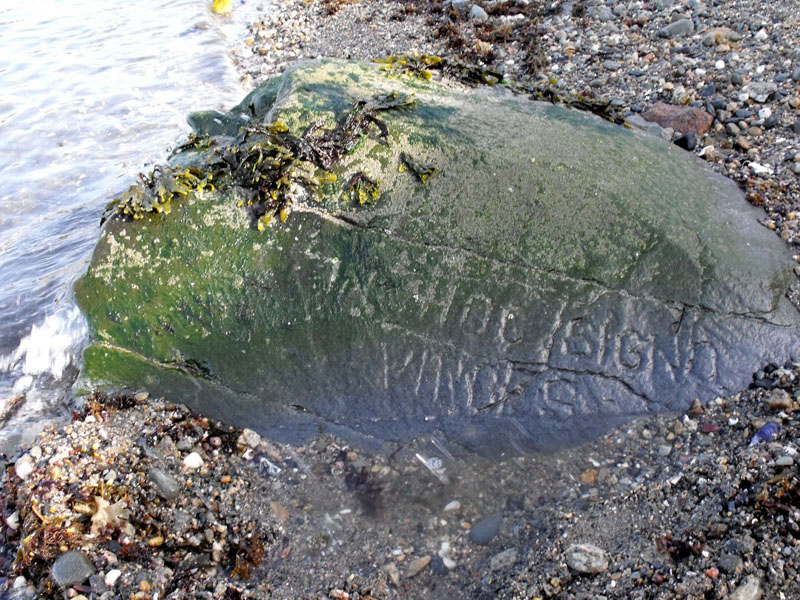
The following photo and caption, suggestive of pre-Columbian habitation at Aquidneck Island and Narragansett Bay where the Newport Tower is located, comes to us from an Internet resource:

'This inscription was found at low tide after a major storm in April, 2010, along the beach in Newport, RI not far from the Newport Tower. The inscription reads, "IN HOC SIGNO VINCES," which is a Latin phrase translating to, "With this as your standard you shall have victory."'

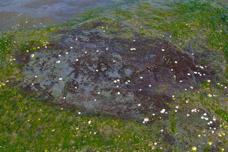
Likewise, there was the deeply carved and weathered Narragansett Rune Stone (since stolen in July 2012), which was visible in the bay at low tide and known about from before 1972. One Internet source speculates that it might mean: 'GIFT of the SUN; RHODE ISLAND (Red Land), now HOME (property) of the MEN across the OCEAN from ICELAND; GIFT of A (God)'.
As stated, to date about 30,000 inscribed stones, many in very ancient European and Mediterranean scripts, have been located in North America, along with European-Mediterranean structures, artefacts and skeletal evidence, etc. These prove long term European occupation, as well as sporadic colonies at latter epochs, spanning thousands of years.
However, according to our mainstream, politically-correct and racially-sensitive, "conformist" historians and archaeologists, these scripts are all just plow-marks, natural scratches and fissures or outright forgeries by darstedly fellows intent upon distorting true history ...
Columbus was simply a latecomer onto the scene and it would be very unsurprising to find that the Newport Tower was a mediaeval structure, built as a multi-purpose, code-bearing repository and mnemonic edifice for teaching the ages-old navigational methods for safe, ongoing traversals of the Atlantic.
In a land of new beginnings, far removed from the "Old-Country", it was important to continue the tradition of passing knowledge of the navigational sciences on to ensuing generations. In earlier times there were huge, sprawling open-air universities like Avebury Henge or Brodgar Ring, with their multitude of "outer-marker" mounds, built at great labour for preserving and teaching these principles.
The Cahokia Mounds complex of Collinsville, Illinois, USA duplicates the mathematical encoding methodologies of the mound complexes of Britain and elsewhere in Europe and shows an ancient, probably Bronze-Age, link between the European-Mediterranean theatre and North America. It also sat on the "copper-route" southwards.
A percentage of the copper mined in the Great Lakes region was being shipped down the Mississippi River to the Gulf of Mexico, then onwards to either European-Mediterranean or South American civilisations. The majority, however, seems to have gone directly to Europe from the Great Lakes, via the Saint Lawrence seaway and across the North Atlantic (circa 3000 to 1000 BC).
The Cahokia Mounds complex sits adjacent to the Missouri River near St. Louis. The river's headwaters start in Montana and join the Mississippi River, with its headwaters in Minnesota, at St. Louis, Missouri. This confluence of two major, branching waterways at St. Louis links back, via tributaries, to the Great Lakes, St. Lawrence Seaway and Atlantic Ocean. To the South of St. Louis there is also the massive confluence of the Ohio River and Mississippi River, providing extensive waterway access to the East as well as South.
The encoded numbers derived from the dimensions of the Newport Tower seem to harp back to the much older knowledge that went increasingly into decline in European spheres of influence with the predations of the Roman Catholic Church, which drove such mathematical knowledge underground to become labeled as "occult science". Although many tradesmen's guilds tried to preserve the knowledge through centuries of religious suppression, there is little evidence to suggest that much of it survived wholly intact, other than some Weights, Measures and Volume standards, by the dawn of the North American colonial era.
Perhaps groups like the Masons preserve the ancient parcel of special scientific numbers in secret and have kept it intact, but there isn't much coming into the public arena to suggest that is the case.
It's plausible to assume that the Newport Tower is pre-Columbian and was built on far-flung shores as a mnemonic structure to preserve and teach the old knowledge that was essential to the concept of "civilisation".
Unfortunately, that mediaeval (?) colony, seeking a new life in North America, like so many others before and after, obviously did not survive the hostile encounters with the natives.
Martin Doutré, July 9th 2013.