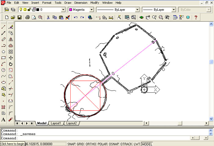
The alignment's component marker co-ordinates, based upon GPS readings, were placed into AutoCAD and produced these precise positions electronically. In this picture everything has been rotated 45-degrees anticlockwise from North to provide a better view. The numbered positions are:
From the obelisk position in Brian Street's farm field, there are stone markers, extending to the river bank, which provide a true North alignment for orientation. The distance from the obelisk to the centre of the field cairn is theorised to have mnemonically represented 118.125-feet at an azimuth angle of 2.835-degrees. Should this prove to be correct by future, careful archaeological assessment, then it is lunar coding. The Khafre Pyramid (Egypt's Pyramid of the Moon) is 15/16ths the size of the Great Pyramid (756 feet per side) or 708.75 feet. Half of this value (354.375 feet) represents the duration of the lunar year (354.375-days...to an accuracy of about 56-seconds). The distance value from the obelisk to the epicentre of the cairn (118.125 feet mnemonically intended?) would represent 3 lunar months (118.125-days). The sum total of all 4-sides of the Khafre Pyramid was intended to produce the value of 2835 feet, hence the 28.35-degree angle theorised to have been established between the obelisk and cairn epicentre. The distance from the Altar alcove through the Avenue, to the outer line of the end gate at the ancient Octagon geometric earthworks complex of Newark, Ohio, USA, is 2835 feet.
The British Standard inch and foot measurements are not British in origin, but were a major part of the incremental values shared by many cousin nations in remote antiquity, whose "cubits" or "reeds", etc., were all based upon the selfsame precise inch. The European/ Mediterranean nations of cousin peoples were using each other's cubits for particular calculations, as they were all a part of the same mathematical parcel, shared culturally and through ratio related weights, measures and volume standards, spanning borders, oceans and continents.
The pyramids themselves represented a "Bureau of Standards" in the many scientific codes that they preserved by way of their distance and angle dimensions, both externally and internally. If one could remember the coded values of these structures then functioning, optimised civilisations could be set up and successfully maintained all over the globe. The pyramids were built as eternal sentinels and repositories of scientific knowledge to do with the equatorial size of the Earth and how to grid reference it for successful navigation. Likewise, they dealt with the duration of cycles, for accurate planting/ harvesting or weather prediction based upon the way the Moon was crossing the Earth's path at any given time during its 18.613-year lunar nutation cycle. The dimensions of the 3 Giza pyramids were often encoded by markers into landscapes across several continents in remote antiquity. This two dimensional pyramid geometric encoding appears to have happened at Koru PA as well.
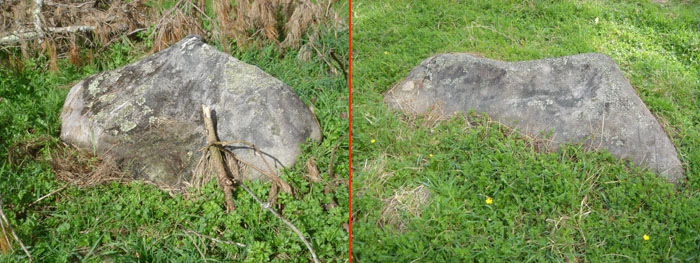
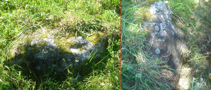
A couple of the carefully chosen boulders, acting as orientation markers in relation to the obelisk position. One associated alignment within Brian Street's farm field gave a "true North" reading in relation to the obelisk position.
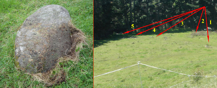
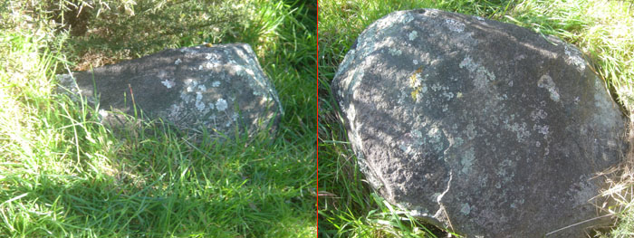
Left: Another large stone acting as a marker. To the right can be seen the region of the field where the ancient surveying markers are distributed. It will be observed that the field is grass pasture, devoid of any natural stone. The same holds true of the surrounding countryside, where there is little or no natural stone on the landscape, except in the river. The otherwise sparse smattering of the boulders encountered, photographed and scientifically assessed by this researcher were, very obviously, "purpose-placed" stones, precisely positioned to serve overland alignment or other code-bearing functions. The above numbered positions are as follows:
PYRAMID GEOMETRY.
In the ancient world, the Pyramids of the Giza Plateau, Saqqara and elsewhere acted as a "Bureau of Standards". If ancient people could hand on a particular parcel of scientific information encoded within numbers, then the concept of successful civilisation was assured. To fail to pass the knowledge on intact was to doom one's offspring to a steady loss of civilisation leading, ultimately, to "survival of the fittest" mentality, brutality, violence and possibly even the degradation of rampant cannibalism as a way of life.
Within the borders of ancient Egypt, where exhumation of pre-dynastic and many dynastic skeletons or mummies shows the earliest inhabitants to have been of Caucasoid (Nordic European) physiology, the ancient astronomers, surveyors, navigators and others of the scientific disciplines could always refer to the pyramid dimensions and angles if a particular morsel of knowledge slipped from memory and needed to be extracted anew. All that was required to regain the knowledge was an accurate measuring rod and a 360-degree compass, along with precise manual instruments like plumb-bobs, gromas, theodolites, alidade sighting rules, etc.
Beyond the borders of Egypt, explorers, miners, traders or the settlers of new colonies around the world had to encode the two dimensional geometric configurations of the Giza Pyramids into the landscapes and set up "standing stone circles" or other forms of ground marker systems, in order to remember and keep eternally safe the numbers of "civilisation".
The migration of the "pyramid" geometry abroad is exemplified by what we find in the layout of sites like Stonehenge.
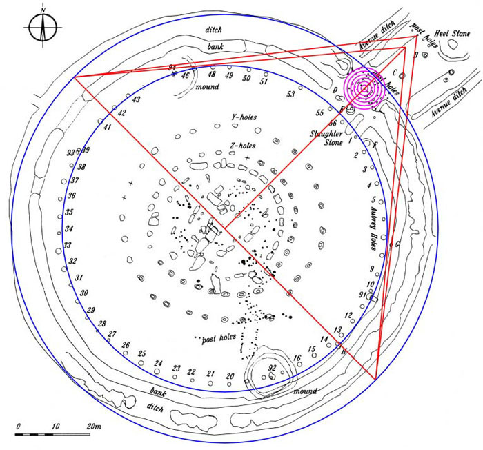
The Stonehenge site, although built to be slightly elliptical in its circular aspect, will best fit inside a circle of 378 feet for a radius of 189 feet from site centre. This dimension (220 Egyptian Royal Cubits) shows a direct affiliation to the Great Pyramid of Egypt, which was 756 feet long (378 feet X 2). If a 1/2 scale two-dimensional pyramid is drawn over the precisely scaled ground plan of Stonehenge, with the apex of the pyramid extending at exactly 45-degrees azimuth into the Avenue, and the pyramid base centred on the centre point of Stonehenge, then the above is the result.
The full, pointed apex pyramid, with a face slope of 51.84-degrees, extends to a post marker on the Avenue and just touches the post. But the Great Pyramid was designed to have a flat floor altar atop it, measuring 44 feet X 44 feet. This floor was at a vertical height of 453.6 feet. At Stonehenge, if lines are sent from the pyramid geometry corners that just brush the edges of the Aubrey Circle, then they converge at approximately 226.8 feet from site centre, representing the position where the flat floor would have been under this half scaling. Note: Three sides of the Great Pyramid @ 756 feet per side = 2268 feet.
It is also very interesting to note that the diameter of the "Y" Holes Circle is 178 feet (pure PHI coding) or 178.2 feet ("rounded" PHI coding). This is 1/2 the intended design length of the Menkaure Pyramid on the Giza Plateau (356.4 feet). Similarly, the diameter of the Aubrey Circle is 288 feet. The design face length up the side of the Menkaure Pyramid was 288 feet. The design face length up the side of the Great Pyramid to the edge of the flat floor altar was 576 feet (288 X 2)...etc.
The two mound positions, with "Station Stones" on them, shown at the top and bottom of the Stonehenge groundplan, sit at 342-degrees and 162-degrees respectively. The same code-bearing, surveying methodology that was used in setting up Stonehenge was also employed at Koru Pa's standing stone circle, half a world away.
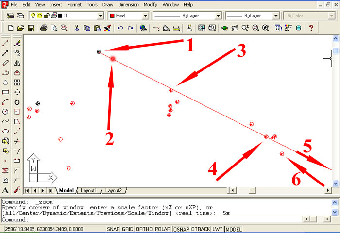
The huge Octagon earthworks complex of Newark, Ohio, North America. It's dimensions and angles were positively based upon measurements and angles from the Giza Plateau of Egypt. Shown above is a meticulously reconstructed, scaled representation of the Octagon, created by this researcher in AutoCAD, by superimposing electronic lines over the accurately drawn and scaled Abrams' Survey Map for the City of Newark (1958). The 5 large sheets, purchased from Newark City Council, were donated for in-depth analysis by Octagon researcher, Patricia Mason of Newark, Ohio. Upon receipt of them in New Zealand they were digitally copied by Reprographics Ltd for insertion into the architectural program, AutoCAD.
The red square shown represents the exact base dimensions of the Great Pyramid of Egypt and the "circle" component of the Octagon was built to those exact dimensions. The magenta line shown lies on an azimuth angle of 51.84-degrees. The slope angle of the Great Pyramid was 51.84-degrees. The length of the magenta line, extending from the altar alcove to the outer line of the end gate is 2835 feet, The Khafre Pyramid has a base perimeter of 2835 feet (708.75 feet per side or 15/16ths the size of the Great Pyramid @ 756 feet).
For an article related to Great Pyramid, Khafre Pyramid & Menkaure Pyramid geometry built into the New Zealand landscape at Maunganui Bluff, Northland, go to: http://www.celticnz.co.nz/Waitapu_Valley/Waitapu5.htm
PYRAMID GEOMETRIC CODING AT KORU PA?
On the interim ridge, obscuring views from the Koru PA standing stone circle hubstone to Mt. Taranaki, are a series of carefully placed marker stones, hauled to that high location at great labour. They are situated in such a way that they would have been very conspicuous to an observer on the standing stone circle. They also sat at an elevation that was comparable to the height of the top plateau of Koru PA, where both a standing stone and Nui Pole (?) were precisely placed. The ridge markers would also have been in full view of an observer sighting across the valley from the top plateau. Let's look at some more of these ridge marker stones:
In one short stretch of the declining ridge a series of boulder markers have been placed in a relatively straight line at precise intervals. They act as surveying and triangulation targets, for distance and angle determinations, from marked strategic positions atop Koru PA or from the lower-elevation hubstone of the standing stone circle.
Above: Two more of the markers that sat at precise intervals in one short stretch of the ridge.
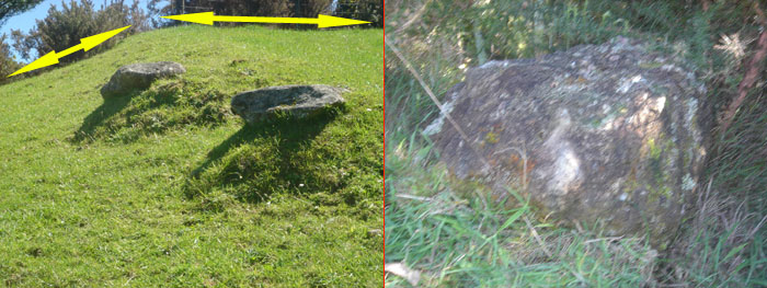
Left: The yellow arrows designate the edge-line of the declining ridge where the majority of the boulder markers were situated in full view of the Koru PA hubstone or from the Nui Pole and standing stone positions on the high plateau of the PA. The short-distance flat seen is where a tractor road was cut and the markers in the foreground might have been disturbed when that was done. Given their position, slightly inward from the ridge edge-line, they would only have been seen from the top of Koru PA but, seemingly, not from the low aspect hubstone of the standing stone circle. This set of "dual stones" is located each side of S 39, 07, .891. E 173, 59, .491. (NZMG 2595777.33, 6229918.24).
Right: The last boulder in the lineup facing the Koru PA hubstone or the top plateau of the PA. Let's now see what these stones seem to have had coded into their individual positions:
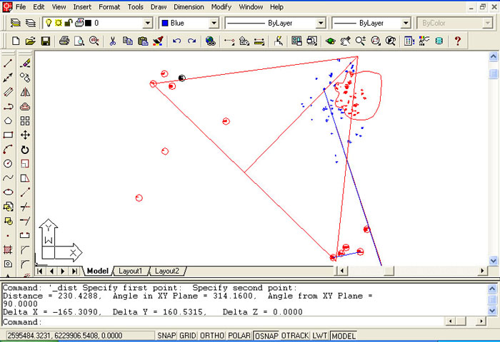
The Great Pyramid two-dimensional geometry shown at full size, or on a scale of 1 to 1. The base stretches 756 feet from the Nui Pole position atop Koru Pa's high plateau, through the centre of the lowest boulder marker on the ridge. The degree angle back from the middle of that boulder to the Nui Pole position is 314.16-degrees. This is coding the PI ratio, wherein the circumference of a circle is 3.1416 times the circle's diameter. So, just as PHI (1.6180339) was being encoded by the alignment from the obelisk in Brian Street's field to Mt. Taranaki, this alignment from the ridge to the Nui Pole seemingly codes PI (3.1416 X 100).
Under this hypothetical representation, the centre line of the Great Pyramid's two-dimensional geometry passes over the hubstone of the standing stone circle. The amount of base distance error detected in GPS readings of both the Nui Pole position and the ridge marker position would show a shortfall on the Great Pyramid base-length of about 14-feet. This could be partially attributed to the expected error (about a metre) in GPS readings or the fact that the ridge boulder has been pushed over from it's original standing position. This is a good example of where a Trimble GPS Total Station 4800 or comparable state-of-the-art GPS equipment could provide the final refinements, by eliminating small amounts of positional error.
The above example is given as an indication of just how much we all have to "raise our game" and start looking very clinically and scientifically at our New Zealand landscape.
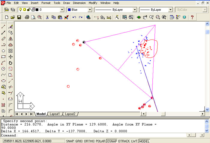
The Khafre Pyramid two dimensional geometry shown at full size, extending from the standing stone position atop Koru PA for 708.75 feet to the highest marker boulder on the ridge. The degree angle back from this ridge position to the stone marker position atop Koru Pa's plateau was 129.6-degrees. Under the ancient Sumerian/ Babylonian 360-degree system, each degree broke down into 60-minutes and each minute broke down into 60-seconds. Therefore, 360 X 60 X 60 = 1296000 seconds of arc in a 360-degree circle. This alignment is, seemingly, coding the 360-degree system and using the 129.6-degree azimuth as a mnemonic device.
In the line of ridge marker boulders, one of them sits within 4-feet of the 756 foot distance that would describe the length of the Great Pyramid's base, with a return angle of 132-degrees to the Nui Pole position. Whereas the 756 feet (7.5 seconds of arc) of length represented 1/8th of 1-minute of arc for the equatorial circumference of the Earth under the Great Pyramid's literal system, the 132 value was directly related to the "Mile" measurement. At Stonehenge the "Station Stone's Rectangle" measures 264-feet down its long sides (132-feet X 2). The "Mile" @ 5280 feet is 132-feet X 40.
Under this alternative number family reading (11-series), the Great Pyramid's length was symbolically extended 3-inches to represent 756.25 feet or 3025 feet for a full circumnavigation (half a minute of Earth equatorial arc instead of 3024 feet). This system used the British mile of 5280 feet for navigation instead of the Greek mile of 5250 feet and under this reading the equatorial circumference was considered to be 24750 miles of 5280 feet each.
There was yet another system that described the equatorial circumference as 12 X 12 X 12 X 12 X 1.2 miles. This gave an equatorial circumference as 24883.2-miles. If those miles were described as Greek miles of 5250 feet, then the reading was EXACTLY what is encoded into the Great Pyramid's literal base length (756 feet = 1/8th of 1-minute of arc). If the reading was used to describe miles of 5280 feet, then that gave the TRUE size of the Earth to a shortfall distance of only 18.8 miles against the figure we use today.
These systems were set up for ease of navigation and grid referencing the world for successful and safe traversal. Both the "Greek" 6&7 number family system of navigation (which is what is literally found on the Great Pyramid) and the "British" 11 number family system (which represents the Great Pyramid as 3-inches longer per side) were very easy to use in positional plotting by navigators at sea... thus, ancient ships were able to sail to New Zealand at "The very ends of the Earth" and set up a long-term civilisation, which endured for thousands of years until it was annihilated by the late arriving warrior cannibals.
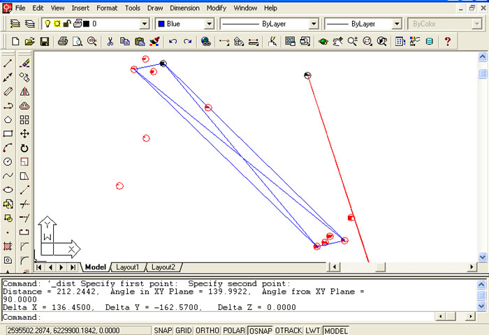
Just as the Stonehenge site was laid out from four Station Stones, the Koru PA site seems to have been similarly conceived. The stones situated on raised ground on each side of the valley appear to form a parallelogram about 70 feet wide. The diagonal distance from the Koru PA plateau stone to the lowest of the ridge stones appears to be 696 feet at an angle of 140-degrees. What was probably coded to the value, 691.6 feet. This would be in deference to 69.16-miles of 5280 feet, which was 1-degree of equatorial arc under the TRUE reading of the Earth's circumference @ 24883.2-miles. Mnemonic recall of 1-degree of arc under the other numerical family systems (68.75-miles & 68.72727272-miles, which is simply a decimal way of saying 68 & 8/11ths) would also have been built into this position... if it was so used. In each case, the outer lines of the parallelogram appear to have coded 314.16-degrees (mnemonic for PI @ 3.1416) in their return angles from the ridge to the Koru PA plateau. The distance code for these lines appears to have been 742.5 feet, which is a part of a navigational progression. Experimentation with parallelograms incorporating some of these values should divulge what the mathematical possibilities were and the plausible code-bearing design configuration that was being employed.
The diagonal distance from the Nui Pole (?) to the double stones lying outward from the edge-line stones appears to have represented 792 feet, again at the azimuth angle of 129.6-degrees. If further refinement verifies this hypothesis, then the distance is coding the diameter of the Earth (7920-miles...which is 24883.2-miles ÷ 3.141818182...a navigational form of PI like 22/7). As to the degree angle code, there would be 192 increments of 129.6 miles in 24883.2-miles. Similarly, the Precession of the Equinoxes was said to endure for 25920-years (12960-years X 2...or 360 years X 72). This is why the sun "lives" in one house of the Zodiac (there are 12-houses) for 2160-years before moving into another house during the 25920-year cycle of Precession.
Any of these across valley lines, of known length and angle could have been used as "Surveyor's base-lines" for working out, by trigonometry, the distances to far off landmarks. All the ancient surveyor needed was the SINE values for the angles derived to the landmark, as viewed from each end of the base-line. These SINE values could be recorded on a "Qippu" (South American name...rendered "key-pu") string knot device, which recorded complex numbers and information by a series of knots on a string. Here in New Zealand our ancient people also used "Kupu" (rendered Koo-pu), which were the same wads of knotted strings, seemingly serving the same function as what the Aztecs and others of South America used them for.
All over the South Pacific there are cut stone pyramids, incised stones, standing stone arrangements, obelisks and tangible evidence of a very ancient but sophisticated civilisation that inhabited the entire region, then disappeared. Their "Oceania" stone-works and cultural expressions duplicated what was put in place in North or South America, Continental Europe or the entire Mediterranean Basin and further afield. According to our experts, none of this came our way to New Zealand... which might suggest that our archaeologists lack the training and skill to see what's so vividly on our landscape... or have their heads stuck in some place where "the sun don't shine".
In the next section (to be added) we will consider the probable, intended coding for each yet-decipherable position of Koru PA's standing stone circle.