NEARER IN AT DOWTH-NEWGRANGE-KNOWTH TOWNLANDS
A series of quite sophisticated and labour-intensive structures sit to the south, southeast and southwest of Newgrange, which itself sits in a more central position between Knowth and Dowth Henge. Let's triangulate onto a selection of these, as well as other satellite structures circuiting away from both Dowth Henge and Knowth chambered mound to extract their intended, in-built codes of position.
Let's see if students, issuing forth from the 4 separate start locations, could find the selfsame outer markers by traveling using exclusively coded distances and angles?

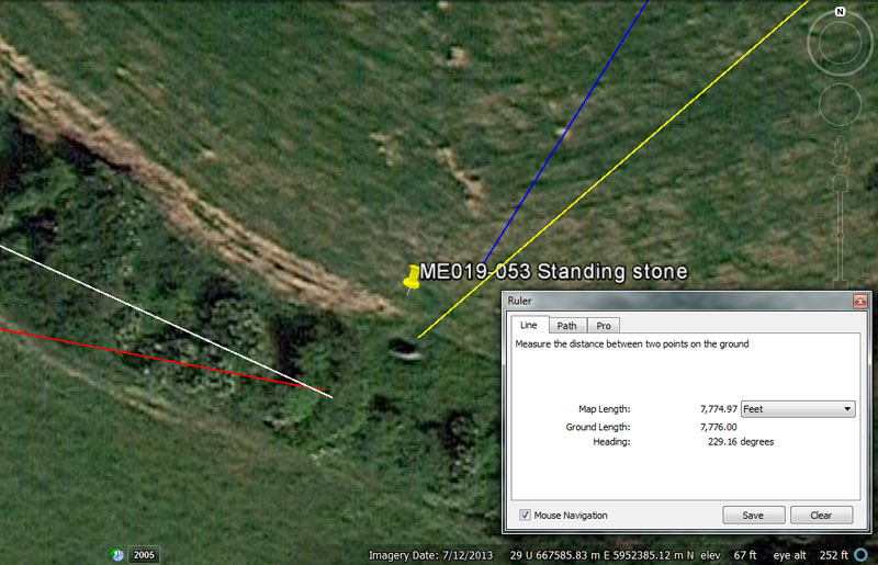
Each of the vectors flowing in to this standing stone position, from the 4 main benchmark centres of Knowth, Newgrange and Dowth chambered mounds, as well as Dowth Henge, are coded by way of distance or angle and the numbers generated are from a parcel of special, factorable, scientific numbers. It can be seen that the line coming from Dowth Henge (yellow) finds its target exactly, whereas the others resolve 'round-about. All coded distance and angle values given would have been sufficient for each team of orienteers to find their objective.
(1). This stone sits at the coded distance of 7776' from the centre of Dowth Henge (yellow line) on an angle intended to convey 229.16666-degrees (229 & 3/5ths degrees.
In the 24883.2-mile equatorial circumference, the sum of 777.6-miles would be 1/32nd part (11.25-degrees or 675 minutes of equatorial arc).
Regarding the angle code, under the navigational system that
used a mile of 5280', 1-degree of arc was 68.75-miles and 1/3rd of that distance
would equate to 22.916666-miles or 121000' or 20 minutes of equatorial arc.
Rendered as a simple whole number and fraction, 22.9166666 equates to 22
& 11/12ths.
(2). At the same time, the intended distance and angle codes the ancient surveyors wished to accentuate in this position from Knowth chambered mound (white line) was 7040' @ 114.58333333-degrees (114 & 7/12ths). This angle X 2 = 229.166666.
The value 7040' is related to the mile of 5280', which is .75 (3/4ths) of 7040'.
The sum of 11.45833333-miles (11 & 11/24ths) would be 1/6th of 1-degree or 10-minutes of equatorial arc under the 5280-mile navigational system, which configured the Earth to be 24750 English miles in equatorial circumference.
At the same time, an overshooting distance of 7087.5' from Knowth chambered mound would, undoubtedly, have been used in tutorials related to this stone's position or to another marked position on the platform upon which it stood. Perhaps that 2nd reading was also, once, marked by a stone.
The sum of 7087.5' is in homage to the lunar year of 354.375-days (half of 708.75) The design-length of the Khafre Pyramid of Egypt is 708.75'.
(3). From Newgrange chambered mound (red line) the distance is 3024' @ 100.8-degrees.
The sum of 3024 feet represents one full circumnavigation of the Great Pyramid of Egypt @ 756' per side. This distance is also 1/2 a minute of equatorial arc for the world (or 30 arc-seconds @ 100.8' each).
The angle of 100.8 degrees is in mnemonic reference to the value for 1-second of equatorial arc.
(4). Students navigating to this spot from Dowth chambered mound (blue line) could travel for 4536' @ 212-degrees (32-degrees return).
This distance is 1/80th of 1-degree of equatorial arc (362880'). It is also 2640 Egyptian Royal Cubits, of which there were 3 types to use, depending upon which navigational system one was working in (ie) 20.618" (Greek mile), 20.625" (English mile) or 20.736" (Note: 20.736-miles would be 1/1200th of the 24883.2-mile equatorial circumference).
The 32-degree angle is in mnemonic reference to dividing the 360-degree compass up into 32nds.
THEODOLITE OR ANCIENT ALIDADE SIGHTING RULE ACCURACY IN SURVEYING
In our modern age of very accurate global positioning information being relayed to us by satellites, the older methods of line-of-sight surveying are largely obsolete. Surveyors do, of course, still use theodolites, but the instruments are, nowadays, highly sophisticated laser devices, a far-cry from the older, but beautifully precision-built optical theodolites of only 40-50 years ago.
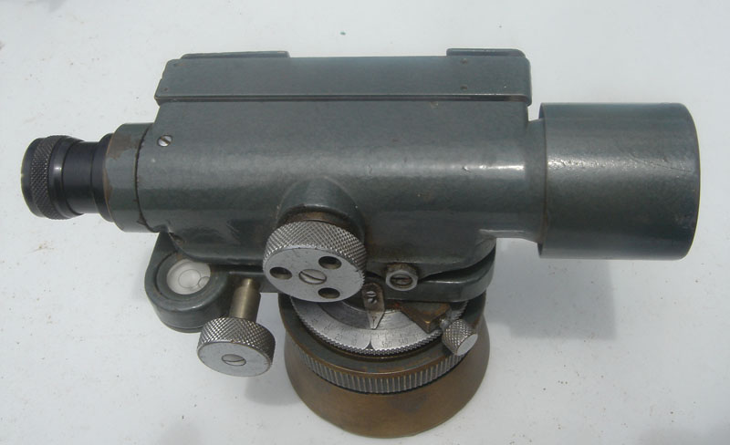
This is the author's old optical theodolite, which was a far better instrument than anything available to the architect-surveyors who set out the Boyne River Valley open-air-university in circa 3200 BC. At the same time, this optical unit is a far-cry from the electronic-laser devices of today, backed up by state-of-the-art gps technology.
Ancient surveyors, for the most part, would be hard-pressed to achieve visual accuracies better than, say, .25 of 1-degree of arc, although they did far better than that in their calculation of where the centre of Dowth Henge should sit in relation to the summit chambered-cairn atop Slieve Gullion Mountain (situated almost 29 miles away, due North) or, equally, to the Ringfort Rath at Drumsawry.
Minor surveying inaccuracies have persisted into modern times and even the modern-day Irish Mapping Grid is being up-scaled to meet the new gps standards.
I received the following, very helpful information from archaeologist, Michael Moore of The Irish National Monuments Service (D.A.H.G ... Department of Arts, Heritage and the Gaeltacht):
'... I note your area of interest, and I will just sound a slight note of warning about the locational information on our website. We try to make it as accurate as possible, but we are dependent to a great extent on maps provided by the Ordinance Survey.
These maps and the projections they are based on have been undergoing changes over the last few years. The old county 6-inch maps that we use for fieldwork and that were used for Archaeology, ie are based on individual projections created by the OS for each county. The O S 1:50000 ‘Discovery Series’ maps that used the Irish Grid system were based on a single projection that I believe went through 8 degrees West.
This Irish Grid was a stand-alone system that was not connected to Britain or Europe, but the OS, together with their European counterparts have created a whole new grid called ITM – Irish Transverse Mercator – which is a part of a Europe wide grid. The outcome of this is that all our old locational data that was based on the Irish Grid or the county projections is now obsolete and inaccurate to some degree.
We are attempting to correct it at the
moment but, this involves checking each site individually and it will take
years. At the moment we can say that data for counties Longford, Sligo,
Waterford, Wicklow and Wexford have been corrected, but the data for other
counties could be out by up to 30m. County Meath hasn’t been corrected
yet, but as far as I can judge, the discrepancy is very small, perhaps less
than 5m in most instances.
I hope this is helpful,
Michael Moore.'
So, for ancient sites that can't, these days, be visually detected in Google Earth (hidden by field crops, destroyed by ploughing, roading, built-over, etc.), but where their precise positions were known and surveyed using the older Irish Grid system, the surveyed position (in some counties) could be off-line by as much as 30 metres.
If this degree of inaccuracy has been the case, even with the sophisticated surveying methods and optical instrumentation of the last hundred years or so, then how much more difficult would it have been to get precise fixes in 3000 BC?
Somehow, by some means, the ancient surveyors achieved remarkably accurate results in they layout of their artificial islands, which were more than adequate to teach successful methods of world navigation.
STEP 1: GETTING STUDENTS TO THEIR FIRST OBJECTIVE.
Students in residence at the main dormitory facilities of Knowth, Newgrange & Dowth chambered mounds or the additional accommodation facilities over near Dowth Henge, were assigned to undertake navigational assignments out-&-about in the surrounding landscape. Plausibly, the novices wouldn't range too far from their home bases and, initially, would have been assigned a reasonably small circuit of, say, 5-10 artificial island sites within, say, a two-mile radius, to visit and describe.
Beginners would, plausibly, have been accompanied by a tutor to teach the rudiments of orienteering and the essential arts necessary for finding objectives. For these rudimentary journeys the students would, undoubtedly, have been given a time-limit of two or 3-days to complete the course, depending on perceived difficulty and weather conditions.
At day's end for each day away from home base, the final objective was, undoubtedly, to locate souterrain or chambered mound accommodation for the night, out of the weather, where one could get a good night's sleep and nourishment, in order to meet the rigours and demands of the next day.
Here, below, are a range of 1st-objectives away from the main centres, from whence the many variable navigational assignments could begin. Student groups consisting of, say, 5-6 individuals, would navigate to their 1st-objective starting point and, beyond that, would conceivably have a completely different set of objectives to find than any of the other groups.
The primary focus was to "do-it-by-the-numbers" in order to memorise the key-values and all objectives had to be found by using special navigation-aid numbers that related to the equatorial circumference of the Earth, different kinds of "miles" in use for the Earth and its divisions, or lengths based upon minutes of equatorial arc, etc.
Some lengths being traveled would relate to the period of the moon, ranging from the lunar year to its long enduring nutation cycle.
It was by this hands-on method of traversing the landscape using only special navigational of cyclic astronomy-related number that the coded numbers were memorised and indelibly imprinted into consciousness, never to be forgotten. Navigation at sea was not possible without knowledge of these special numbers and the intricate, refined calculations that could be generated by their use.
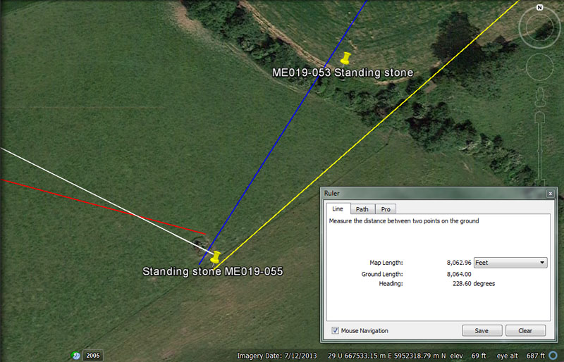
Four code-bearing vectors converge onto this giant, standing obelisk and encompass it 'round-about. Orienteers navigating from four different centres would have no difficulty arriving at and identifying their assigned target, doing it by-the-numbers.
(1) From Newgrange (red line) the distance is 2916' @ 105-degrees.
This distance would equate to (what later became) 3000 Roman feet of 11.664" (11 & 83/125ths) or 600 Roman paces. This distance would also be .6 of a Roman mile.
As stated, for practical purposes and simple mathematical manipulation of this "Roman" foot, it was, undoubtedly, often read as 11.6666" (11 & 2/3rds inches) for overland marching or particular divisions of whole numbers into fractionated form (35 ÷ 3).
The 105-degree coding would be in mnemonic reference to the multi-use value 105. The Hebrew reed was 10.5' and two Greek miles would be 10500'.
(2). From Knowth chambered mound (white line) the distance & angle are 7000' @ 116.6666-degrees. There would be 7200 Roman feet of 11.6666" each in 7000 English feet or 1400 Roman paces of 58.3333". Alternatively, this distance could be read as 1.44 Roman miles of 4860' (using the 11.664" rendition of the Roman foot).
(3). From Dowth chambered mound (blue line) the coded distance and angle are 4860' @ 32.4-degrees return. This distance is, of course, 1 Roman mile (encoded into the Irish landscape about 2700-years before there was a vibrant Roman civilisation).
The 32.4-degrees is in mnemonic reference to a multi-use value, 324, much used in navigational and lunar calculations. For example, the sum of 32.4 miles would be 1/768th of the 24883.2-mile equatorial circumference and 32.4-days would be 1/210th of the 6804-day lunar nutation cycle.
(4). For students navigating from Dowth Henge (yellow line), the distance and angle were 8064' @ 48.6-degrees return. The distance of 6048' (1-minute of equatorial arc under the Greek mile system) is .75 of 8064' (80 arc seconds of 100.8' each).
The sum of 8064' would be 1/16200nd of the equatorial circumference. Likewise, a distance of 80640' would equate to 12 ancient Irish miles of 6720' each. The distance of 6048' (1-minute of equatorial arc under the Greek mile system) is .75 of 8064'.
The degree angle is in mnemonic reference to the multi-use value 486. When tracking the movements of the moon within the lunisolar, Sabbatical calendar system, there were 486 intervals of 5.25-days (7.2 lunar years or 2551.5-days) being monitored alongside 487 intervals of 5.25-days (7-solar years or 2556.75-days). Also, the moon's 6804-day lunar nutation cycle is 486 periods of 2-weeks (14-days).
Of course, the angle was also calling to memory the Roman mile
of 4860'. The so-called Roman mile could be read as 4860' for lunar computations,
based upon a foot of 11.664" (11 & 83/125ths). This value was used
copiously in weights and measures standards , especially in volume calculations*.
Alternatively, the value 11.6666" (11 & 2/3rds), crops up continuously
in ancient computations.
*Footnote: The Egyptian Theban volume was 11664 cubic
inches, whereas their Besha was 1166.4 cu" and Honnu 116.64 cu".
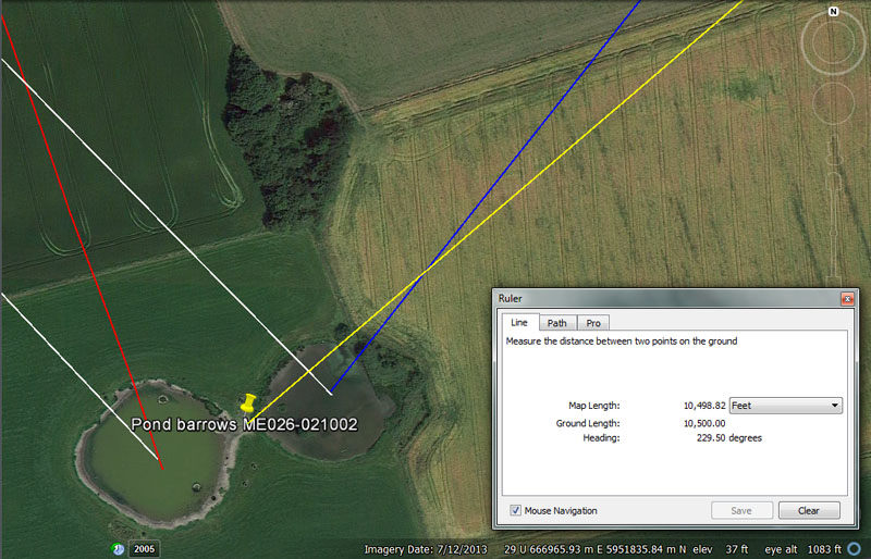
Again, these two, anciently dug, pond-barrows were carefully positioned to allow orienteers traveling overland from four separate points of departure to use coded lengths and angles to find their pre-assigned objective.
(1) Two white lines are seen to extend from the centre of Knowth chambered mound and resolve within the western and eastern pond barrows.
(a). The distance and angle from Knowth (white line) to the centre of the western pond (left) is 6300' @ 138.24-degrees. The sum of 6300' is 1.2 Greek miles of 5250'. It is also 10 Greek stadia of 630' each.
The degree angle is for mnemonic recall of the 24882.2-mile equatorial circumference of the Earth and 138.24-miles would be 1/180th of that circumference.
(b). A second white line runs from the epicentre of Knowth to the eastern pond and resolves near its centre. This line is 6400' @ 136.08-degrees.
The value 64 (8 x 8) was important in many ancient calculations and the chessboard, which probably started out as a calculation matrix, has 64 squares The ancient, Druidic Calendar of Coligny brass plaque, for tracking both the sun & moon on a daily basis, was made up of 128 squares (64 X 2).
The degree angle (136.08) relates to the duration of the lunar nutation cycle, where the moon goes from lunar major standstill to lunar minor standstill and to lunar major standstill again. Ancient scientists used the highly factorable number 6804-days to describe this period (the actual duration is 6798.36-days ... a non factorable number that would not work fluidly in a mathematical progression). The sum of 13608-days would be 2 X 6804-days.
The southern ring of Avebury Henge was coded to represent 340.2' in diameter, or the same as the Brodgar ring in Scotland (2 X 3402 = 6804). The Khafre Pyramid of Egypt (a pyramid of the moon) is 15/16ths the size of the Great Pyramid or 708.75' in length per side. This gives a full perimeter value of 2835' or 34020".
(2). From Newgrange chambered mound (red line) to the western pond (left) the coded distance and angle are 2475' @ 161.8034-degrees.
The distance is for mnemonic recall of the size of the Earth under the 5280' mile system, which was 24750-miles. This distance is also 1440 Egyptian Royal Cubits of 20.625" each or 800 ancient Scottish ells of 37.125" each
The degree angle was for mnemonic recall of the PHI ratio, 1: 1.618034, which absolutely had to be known when accurate, round grain-dispensing tubs were fabricated for the marketplaces. The ancient makers of such tubs had to know the PHI formula in order to square the circle.
(b). In order to avoid cluttering the above picture with too many lines, the vector from Knowth to the eastern pond (right) is not shown. The distance is, again, 2475', but tutorials would have also included 2488.32' (for recall of the 24883.2 Greek mile navigational method).
The angle code to the central region of the eastern pond is 156.25-degrees, which is a multi-use value in both navigational and lunar period calculations.
(3). From Dowth chambered mound to the western pond's central area (blue line) is 7290' @ 39.375-degrees return.
The 7290' distance (also rendered as 7291.6666') is 1.5 Roman miles. The value is also important to lunar cycle calculations within the lunisolar Sabbatical calendar, where 7.2 lunar years (2551.5-days) was monitored alongside 7-solar years (2556.75-days). There would be 3.5 X 729-days in 2551.5-days.
Also, in ancient Roman times they had a nautical mile or sea league of 7290'. This was probably adopted from the conquered mariners of Gaul (the Veneti), as it was called leuga Gallica or leuca Gallica (the league of Gaul).
The degree angle of 39.375 (39 & 3/8ths) is part of an important mathematical progression related to the period of the moon, as well as navigation. The sum of 39.375-days would be 1/9th of the lunar year of 354.375-days or 945-hours. The sum of 39.375' would be 1/16th of a Greek stadia of 630' or 3937.5' would be .75 of a Greek mile.
(b). The vector from Dowth chambered mound to the eastern pond (right) is not shown, but was coded to be 7087.5' @ 38.4-degrees.
The design length of the Khafre Pyramid on the Giza Plateau of Egypt was 708.75' (or 2 X 354.375 ... the duration in days of the lunar year). The use of this distance code at the Boyne Valley of Ireland duplicates coding in the landscape running out from the giant central obelisk at Avebury Henge in Southern England, to the doorway into West Kennet long barrow, which is 7087.5' @ 354.375-degrees.
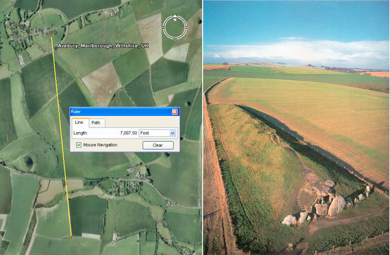
The very important codes related to the lunar year and Khafre Pyramid base dimensions are found in the distance and angle relationship existing between Avebury Henge's centre obelisk position and the doorway into West Kennet long barrow (Southern England). The distance was set to 7087.5' and the return angle from the doorway to the obelisk was set to 354.375-degrees. Very similar coding was incorporated into positions at Cahokia mounds complex in Illinois, USA, with the distance and angle between Monk's Mound hub and Mound 10 ... 3543.75' @ 354.375-degrees.
The angle, in this case, is 38.4-degrees for mnemonic recall of the value 384, used in navigation. The sum of 38.4-miles would be 1/648th of the 24883.2-mile equatorial circumference. Equally, the old Scottish ell measurement had drifted in size slightly by mediaeval times and was approximately 37.1 imperial inches. In a purely mathematical sense, it should have been 37.125" in order to function within the ancient parcel of special numbers and 1920 ells would have constituted 5940' for the ancient Scottish mile (1920 X 2 = 3840) ... which would be 1-furlong (660') larger than the English mile (5280'). Sadly, as the centuries wearied on Scottish measurements, like everyone else's, drifted and their mile was, by a late era, 5952' and meaningless within the ancient parcel of factorable numbers.
At least the Irish managed to keep their 6720' mile pure and undefiled for thousands of years, just as the English did with the 5280' mile and the Greeks with the 5250' mile. The Romans are also to be commended, although their mile finally drifted into semi-obscurity and was all but forgotten.
(4). The yellow line from Dowth Henge runs for 10500' @ a return angle of 49.5-degrees. The sum of 10500' is exactly 2 Greek miles.
The degree angle accentuates the value 495 and the sum of 495 English miles of 5280' would equate to 1/50th of the 24750-mile equatorial circumference of the Earth, or 7.2-degrees of arc under that ancient navigational system.
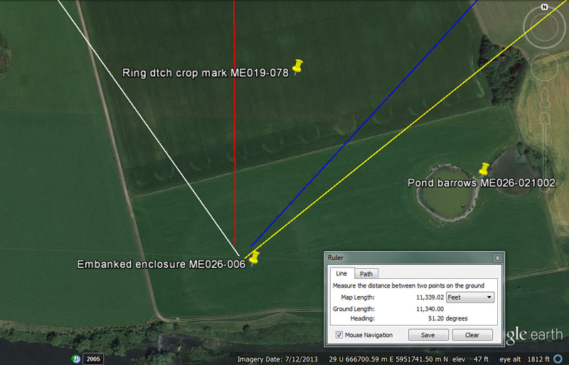
Again, four vectors are seen to converge and resolve 'round-about the centre of this formerly giant enclosure, now reduced to a crop mark by millenniums of ploughing.
(1). The white line from Knowth mound runs to the central region of the enclosure crop mark for either 6000', 6048', or 6050' @ 325. In a site as large as this several variable codes of length and angle are possible for each incoming vector.
The distance of 6048' is 1-minute of equatorial arc under the 5250-mile navigational system and 6050' under the 5280-mile system. Under the marginally variable Roman-mile system it would be read either as 6076 & 7/18ths'or 6075' and circa this length has been the accepted value for a nautical mile since late mediaeval times.
The degree angle (325 return) in a mathematical progression would provide some useful numbers for the 13-month year calendar.
(2).The red line from Newgrange runs for 2520' @ 0-360-degrees (due North-South). This distance would be 25-seconds of equatorial arc @ 100.8' per arc second. This distance would also be 2400 Greek feet, 1200 Assyrian cubits or 240 ancient Hebrew reeds.
(3). The blue line from Dowth mound runs for 7920' @ 42.525-degrees return. This distance is in homage to the diameter of the Earth, which is, quite literally, 7920 miles. This length is also 1.5-miles of 5280' each.
The degree angle is lunar coding and there would be 16 intervals of 425.25-days in the 6804-day lunar nutation cycle or 6 intervals in the 2551.5-days of the moon (7.2 lunar years) monitored within the lunisolar Sabbatical calendar.
The yellow line from Dowth Henge's centre runs for 11340' @ 51.2-degrees return.
This distance value is much used in lunar cycle computations and the 6804-day lunar nutation cycle is 6 intervals of 1134-days. Also, there would be 2.25 periods of 1134-days in the 2551.5-days of the lunisolar calendar. Greek historian, Herodotus was told by Egyptian priests that the Great Pyramid was 800' long. The priests were referring to an increment of 11.34" for lunar readings. Also, 3 side-lengths of the Great Pyramid equal 2268' (756' X 3) which equates to 1134' X 2.
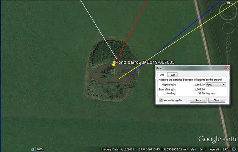
Another pond-barrow is peppered by incoming, coded vectors from the four points of departure of orienteering groups.
(1). The white line from Knowth chambered mound is 4860' @ 148.5-degrees. In coded values, this could also be interpreted as 4900' @ 325-degrees return.
This distance is, of course, the same overland measurement that, 2700-years later, became known as the Roman mile. At the same time the angle (148.5-degrees) that the orienteers from Knowth would have used to navigate to this spot, was part of a mathematical progression that related to the ancient Scottish mile of 5940'. The sum of 1485' would be 1/4th of 5940'.
(2). The red line from Newgrange is 2016' @ 26.4-degrees return. This distance could also be interpreted as 2062.5-feet @ 206. 25-degrees outward angle.
This distance from Newgrange is, of course 1/3rd of 1-minute of equatorial arc (6048' ... or under another, close-proximity navigational method, 6050').
As stated, across the expanse of such a large target, the opportunity was there to have the orienteers from Newgrange travel 2062.5' @ a return angle of 206.25-degrees. This distance would be 1200 Egyptian Royal Cubits, of which there were 3 very close-proximity types, 20.618" (as on display at the Turin Museum), 20.625" (20 & 5/8ths ... identified by Petrie), as well as 20.736" (as found by Petrie in the measurement of the coffer in the Great Chamber of the Khafre Pyramid of Egypt and the paving slabs at the base of the Great Pyramid).
These 3 variable "cubits" served as mnemonic devices for remembering the equatorial circumference of the Earth under 3 navigational systems. The simple formula was: Length of the cubit in inches X 1200 ... then read the result as miles of 5280'.
(3). The blue line from Dowth chambered mound extends for 8100' @ 50.4-degrees.
This value is multifunctional and much used in a mathematical progression generating values for tracking the period of the moon. For example, the 6804-day lunar nutation cycle is 81 intervals of 84-days, or the 2551.25-day period of the moon (7.2 lunar years), daily monitored within the lunisolar calendar, is 81 intervals of 31.5-days (756-hours).
But there is a far more profound meaning in this number that is in mnemonic reference to the PHI ratio, which was of manifold importance to ancient Mediterranean-European civilisations.
The PHI ratio is 1: 1.6180339 and a rounded form of PHI (1.62, 16.2, 162, etc.), was much used in the metrology systems of ancient great civilisations. It was essential to know how to square the circle, using the PHI ratio, in order to fabricate round measuring tubs of perfect cubic inch capacity for dispensing quantities of grain, etc., in ancient marketplaces.
The distance from the centre of Dowth chambered mound to this pond barrow would also have been read as 8090.17' in tutorials related to the PHI ratio, which had a half value of .809017.
The angle of 50.4-degrees offers a tutorial related to 1-second of equatorial arc, which was 100.8' (50.4' X 2).
(4). The yellow line from Dowth Henge is 11664' @ 56.7-degrees return.
This distance is 2.4 Roman miles. It could also be read as 12000 Roman or ancient Swedish feet. The measurement equated to 2400 Roman paces or 2000 ancient Swedish famn (fathoms). See: http://www.celticnz.co.nz/VikingNavigation.htm
The 56.7-degrees return angle of travel, that orienteers from Dowth Henge would use to find this objective, is both lunar and navigational coding simultaneously.
The 6804-day lunar nutation cycle is 12 periods of 567-days. Likewise, the 2551.5-days (7.2 lunar years) monitored within the lunisolar Sabbatical calendar (alongside 7 solar-years) is 45 periods of 56.7-days.
In a navigational sense, 3-minutes of equatorial arc ( 18144') would equate to 32 X 567'.