ANOTHER OUTER FIX POINT FOR DURRINGTON WALLS HENGE.
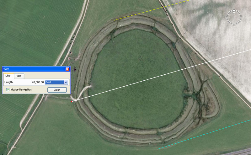
On the outskirts of Berwick St. James village is another impressive henge, which carries sophisticated distance and angle codes in its centre to centre relationship with Durrington Walls Henge.

It appears that the larger or more impressive outlying sites are awarded the honour of carrying the most sophisticated codes of position, Thus, Silbury Hill sits in a PHI code-bearing relationship to Barbury Hill (the true North fix point for Durrington Walls Henge). As an appendage or satellite to Durrington Henge, this one shown contains several stages of codes through its centre, as well as each edge. The return angle, centre to centre to Durrington Walls Henge is 73.828125-degrees. Although this value looks complex in decimal form, it converts to a fraction of 7353/64ths and, as part of a very sophisticated division within the lunar coding system, is on a par with the PHI coding that runs from Silbury Hill to Barbury Hill. Here are the coded stations that would have run through the centre of Berwick, St. Jame's Henge:
RE-EVALUATING THE SURVEYING AND MATHEMATICAL ABILITIES OF OUR ANCIENT ENGLISH ANCESTORS.
It might be a very big mental leap to take, especially after years of being dumbed-down and having it constantly reinforced that our distant English ancestors were little better than illiterate cavemen, but, as it turns out, they were very advanced and highly educated people. Most certainly, at the very least, there were schools and groups amongst them in possession of great scientific knowledge and surveying-mathematical abilities. Others obviously pursued more mundane activities as farmers, builders or artisans within the trades, but when it came to building the henge & mound complexes, there was tremendous inter-cooperation and community input from every sector of society.
We will now begin to consider the many codes of position built into the hundreds of mounds that dot the landscape around Durrington Walls Henge and this exercise should be sufficient to demonstrate that there was nothing arbitrary or meaningless in the placement of the mounds. In an age where there was a scarcity of paper for making books, other methods had to be used to preserve the hard-won and precious sciences for all future generations. The method chosen was to encode all of the "special numbers" into the landscape where they would reside permanently and could be extracted by precise surveying and measurement practices. This encoding was coupled with the availability of highly educated tutors who knew the meanings of all of the intended numbers associated with marker positions and could explain them in-depth to initiates. The initiates themselves had to memorise a vast array of factorable numbers and learn their varied applications to navigation, cyclic astronomy and the calendar. There would have been intense memorisation of the "times-tables", mathematical progressions and all of the factorable numbers within individual number families.
Although the numbers being learnt can look intimidating, they are simply whole numbers and fractions. All of this is basic arithmetic and geometry. Profound thinkers and reasoners, dwelling on a mathematical problem, would have solved the problem over time. The big accomplishment was to know the exact (or very near) equatorial circumference of the Earth, as well as the precise durations of various milestones within the lunar cycle, and then to design a measurement & angle system that described everything in factorable numbers.
Here is a glimpse of what we have to contend with:
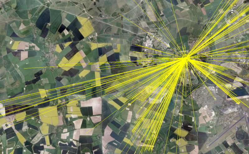
Lines are seen to originate in the very centre of Durrington Walls Henge and extend out to the hundreds of scattered mounds or minor henge structures in the district. Each line shown is code-bearing and carries highly significant scientific information in the numerical values generated by the distance and angle. The codes for each line shown have been worked out, but there are many more on the Durrington landscape yet to be deciphered.
And, in fact, that's really all it takes to figure out what these ancient builders were doing. All can be extracted by careful surveying and then trying to make sense of the recurring numbers generated at these multiples of purpose-placed marker-sites around Durrington Walls or, indeed, at individual sites across several continents, where the selfsame cousin nations went and set up civilisations. The numbers are highly factorable, logical and directly applicable to the particular scientific functions that they serve. Clues as to what they are have survived in the known standards of ancient weights, measures and volumes, vestiges and fragments of which have survived into modern times.
LET'S START WITH AN EASY ONE.
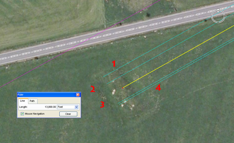
This barrow mound is part of the Normanton group and sits at Lat: 51.174942. Long: -1.836267. The primary coding of the structure relates to the equatorial circumference of the Earth and also what constitutes 1-minute of arc for each three of the separate navigational and positional plotting systems. One coded angle relates to the cycle of the Moon. The aqua-blue AutoCAD vectors slightly overshoot the barrow, but the very accurate Google Earth measuring tool fixes the crest of the barrow at 13068-feet from the centre of Durrington Walls Henge. The distance to the barrow, of course, codes the 24750-mile equatorial circumference, which equates to 130680000-feet. This was the system that survived in Britain, using an "11" based league of 16500', a mile of 5280', a furlong or furrowlong of 660', a chain of 66', a rod or perch of 16.5', a fathom of 5.5' (later changed to 6') and a link of 7.92-inches.
In consideration of the distance to the southwest embankment, two additional length codes could be achieved, including 13125-feet, which accentuates dynamic lunar cycle coding.
TWO MILE MOUNDS
A typical grouping of mounds sit out two miles, centre to centre, from Durrington Walls Henge and provide us with some appreciation as to just how intensive the navigational training was at this vast, sprawling open air university. The cluster of mounds is situated just to the northwest of Stonehenge at Lat: 51.184109, Long: -1.830658.
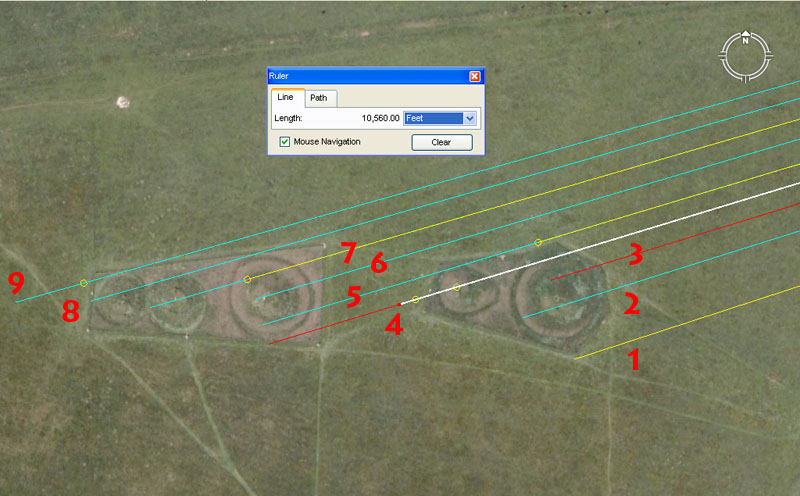
Five mounds of the Cursus Barrow group are clearly in evidence in this picture, with yet another 3-5 vague, ploughed-over mounds sitting centrally or to the West of the main cluster. A series of 9 lines are seen to be emanating in from the centre of Durrington Walls Henge and resolving onto this position. Of these lines, most are double or triple coded as they brush past one mound to resolve at positions on another. In the centre of the grouping there appears to be the vague outline of a ploughed over and otherwise erased mound and this position represents exactly two British Standard Miles (see Google Earth distance panel) from the epicentre of Durrington Walls Henge at a return angle to the henge of 73.33333-degrees (731/3rd).
Here are some of the codes of position (tutorials for ancient apprentice-navigators) related to these mounds:
1.The distance is 10240-feet from Durrington at an angle of 252-degrees.
The distance of 10240-feet provides a numerical value related to the equatorial size of the Earth under its 24883.2-mile assignment and, amongst other things, provided a formula or mnemonic device for remembering the equatorial circumference. The sum of 102.4-miles X 3 X 3 X 3 X 3 X 3 = 24883.2. The sum of 1024-miles = 32 X 32-miles or 4 X 4 X 4 X 4 X 4. In a modern age where we enjoy the luxury of electronic calculators, such mnemonic methods may seem trite, but in an age when there was not any great availability of perishable paper to create books, and a situation where complex calculations were expedited by abacus devices, there was heavy reliance on memory to learn the factorable number families, as well as how those numbers related to astronomical cycles or methods of navigation. The problem was somewhat akin to how a modern jazz musician, doing improvisation, memorises all of the chord families through the full range of scales and how they relate to each other harmonically ... then practices intensely until everything becomes second-nature and automatic.
The angle of 252-degrees relates to the "6&7" (so-called Greek) mile of 5250-feet. Two Greek feet equate to 25.2-inches and 5000 Greek feet = 5250-feet. A Hebrew Reed was 10.5-feet or 5 increases of 25.2-inches.
This vector resolves to the southern side of the mound and, in most cases a mound will carry codes for each side, plus the central area.
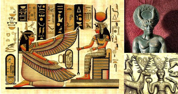
For individuals with a background in surveying or the trades, this stylised Book of the Dead panel of Isis on her throne contains many recognisable objects that would work effectively in surveying and measurement applications. Latter-epoch Egyptian "religion" is merely a corruption of earlier scientific knowledge encoded by measurements and angles. The extended straight-edged "wings"denote measurement. The diagonal feathers denote varied angles, as well as "counts". The staff of Isis denotes a graduated measurement rule and plumb-bob type device that would be useful for marking vertical lines down the faces of walls. Her throne denotes right-angles and horizontal lines and is very geometric. The background panel has water level bowls, ankh eyelet sighting devices, a measuring rod and the snake could symbolically depict a measuring rope*, etc.
* Footnote: The ancient Egyptian measuring rope (the old term for "surveyors" was "harpedonaptae" or rope-stretchers) was treated to hold its length. It was stretched taut between stakes and then rubbed with a mixture of beeswax and resin. Some of the ropes depicted in hieroglyph were graduated by knots tied at intervals. Accuracy was creditable, according to a 1909 triangulation survey that tied some original boundary stones. The Egyptian crews set the stones to divide the fertile Nile delta, and the "rope" was indispensable for measuring the distances.
Some of the oldest legends of Ireland speak of forebears coming out of (returning back from?) the far reaches of Mediterranean to settle that land, although there were yet earlier migrations from Ireland to the East. With these latter immigrant groups fleeing from oppression in the Mediterranean to a new homeland in Ireland (Firbolgs, etc.) they brought their harps, bagpipes, kilts, Gaelic language forms, myths & legends, measurement & angle standards and even the venerable oak tree, etc.
The measurements found on the pyramids of Egypt are the same (or direct ratio expressions of) the earliest standards shared between the cousin European nations. The earliest mummies of Egypt are Caucasoid. Along with cultural idiosyncrasies, the Europeans shared many of the same gods and symbolism as persisted in Egypt or its environs. Isis, for example, was a very early era Proto-Celtic goddess, as were Athena & Zeus, etc., who became Greek deities after Sea People (Celtic) migrations into the Mediterranean.
Of interest in the above pictures is the horned crown, for the symbolism that can be associated with it. On the Avenue at Stonehenge is a small group of posts set out as concentric rings. By running flaring lines from the centre of the site to the sides of the rings, the lines increase in angle by 1/2 a degree at a time. This was, undoubtedly, the deeper meaning behind the crowns of Isis - Hathor of Egypt or Cernunnos-Herne-Puck of Europe. The concept of lines flowing to the sides of concentric orbs gave birth to the very ancient Hebrew menorah design (having no relationship to the much latter-era Ashkinazi-Jewish people of Khazaria who adopted the design after 720 AD).
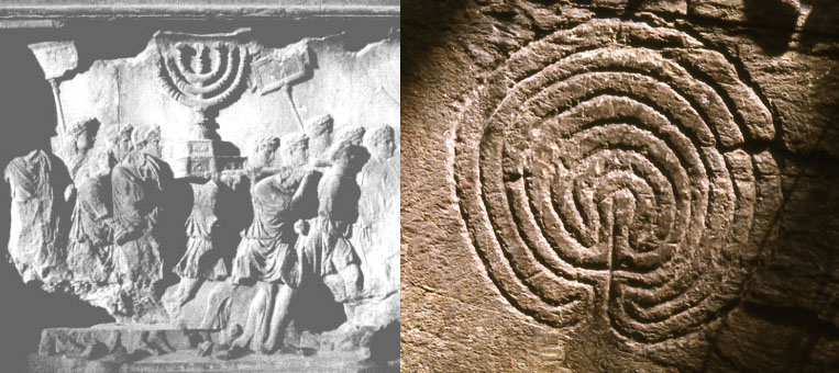
Left: In the above wall relief picture, Romans are depicted carrying away the Menorah Candelabra from the sacked Temple of Solomon in Judea, which, at the time, had been in the possession of the Babylonians for over 600-years. The Babylonian Pharisee religion had used the earlier Hebrew Menorah.
About 1350-years after Babylonian King Nebuchadnezzar's conquest and annihilation of the Hebrews, King Bulan of Khazaria (1000-miles North) adopted the Babylonian Pharisee religion (earlier practiced in Judea) as his state religion (He'd also considered both the Christian & Muslim faiths). His choice gave birth to the "Jewish" faith-ethnicity, which is today about 95% Ashkinazi-Turkish in root origin, with about 5% of lineages attributable to Babylonian refugees fleeing before or surrendering to the Roman armies of Titus (circa70 AD). Those who stayed on in Judea after the Roman subjugation of the Judean-revolt became, for the most-part, the Palestinian people of today, who converted to the Islamic faith after 600 AD.
Right: The Menorah design is quite obviously a latter development of the Labyrinth design, incised into early British and Scandinavian (The Sea Peoples) boulders or cliff-faces (Neolithic rock-art) since 3000 BC or earlier.
2. The distance is 10312.5-feet and the azimuth angle is 72.6-degrees return to Durrington Walls Henge centre.
The distance would equate to 6000 Egyptian Royal cubits of 20.625" each (205/8ths). This was the "11" family cubit.
The angle (72.6-degrees) is also a navigational value from the "11" family of numbers and 7260' would equate to 1/18000th of the 24750-mile equatorial circumference.
3. The distance is, again, 10240-feet and the azimuth angle is 72.9-degrees return to Durrington Walls Henge.
The angle provides values in both lunar and navigational progressions. It is also associated with the so-called Roman measurements. The Roman Pace was 58.32" (7.29" X 8). Very close to these Cursus mounds reside the Normanton barrows, one of which (Bush Barrow) contained a gold lozenge artefact (the Bush Barrow Lozenge) measuring 7.29" in length. The Roman measurements are found in the Neolithic British landscape and were put there up to 2500-years before there were any Romans.
4. This line has 4 length codes associated with it, which resolve onto various of the mounds within this cluster. These lengths are 10454.4-feet, 10500-feet, 10560-feet and 10800-feet. The azimuth angle of this line is 253.125-degrees (2531/8th).
The length of 10454.4 relates to the 24750-mile equatorial circumference, of which 1045440-feet would equate to 1/125th part. The sum of 10500' is two Greek miles. The sum of 10560' is two British miles. The value 108 has many applications in ancient calculations. For example: the sun spends 2160-years in each house of the zodiac during the cycle of precession or 20 periods of 108-years. There would be 24 periods of 1080-years in the 25920-year precessional cycle.
The 253.125-degree angle from Durrington Walls centre to this position is strong lunar coding and 25.3125-days would be 1/14th of the lunar year.
5. This line carries 4 lengths associated with it, including 10240-feet, 10500-feet, 10560-feet and 10800-feet. The return azimuth angle back to Durrington Walls Henge is 73.333333-degrees.
The 73.333333-degrees (731/3rd) relates to navigation under the "11" family of values and 73.333333' would equate to 1/72nd of a mile.
6. The line resolves in the centre of a mound at a distance of 10800-feet from Durrington Walls Henge at an apparent azimuth angle of 737/11ths-degrees.
This value is part of a mathematical progression that relates to both navigational and lunar calculations simultaneously, reduced by sevenths.
7. This line has two length codes associated with it at 10800-feet and 11000-feet. The azimuth angle is 73.828125-degrees (7353/64ths).
The duration of 7.3828125-days would equate to 1 lunar week or 48 X this period would be 2 lunar years.
8. The length to this point could be interpreted by the tutor to mean 11108.57142857' (111084/7ths) at an azimuth angle of = 74.05714286-degrees (742/35ths).
The length relates to the equatorial size of the Earth and navigation reduced in seventh values and so does the angle. Although these values look horribly complex when rendered as decimal fractions, for ancient mathematicians they were just as easy to calculate as any other fractions. When learning to manipulate numbers as factors or fractions, none of the number families could be neglected and all were used for various kinds of calculations. For example, the major increments within the ancient chronology system (which we still use) relate to time periods of 7 intervals (week of 7-days). The Sabbatical Calendar combined the numbers "6&7" and calendar periods are divisible by either, just as are (so-called) Greek length measurements (5250'-mile; 6300'-stadia; 525'-short stadia; etc.).
It must be remembered that this was an "open-air-university" and a place of very intense navigational (arithmetic & geometry) and astronomical training. Anyone attaining the office or qualification of a navigator on a ship had to know how to complete calculations in their head and stay abreast of the ship's exact position in the vast, featureless ocean. Lunar, stellar and solar cycles had to be very well understood as an aid to navigation and positional plotting. This was not just some kind of laid-back holiday camp, but more so a very focused school for over-training over-achievers!
9. 11250-feet @ 74.25-degrees.
The length is self-explanatory. The 360-degree compass was mostly broken down into 320 parts and 1/32nd of 360-degrees is 11.25-degrees.
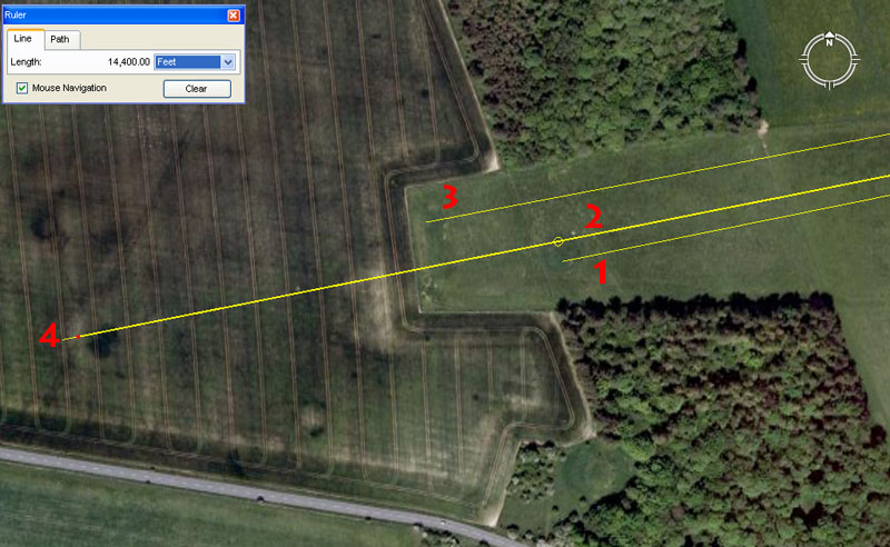
A series of mounds are shown at the end of the Cursus, as well as the mottled marks of former mounds in the field further West. Another large mound is shown semi-encompassed by trees, South of the Cursus group. Four positions from this sampling have been numbered for consideration of their positional codes, which are:
1. A line extends for 2.5-miles from the centre of Durrington Walls Henge and resolves South of centre on this mound. The azimuth angle back to Durrington Walls centre is 78.54-degrees.
The distance out from Durrington Walls is self-explanatory.
The angle relates directly to a mathematical progression to do with PI and fractions thereof. The sum of .7854 is 1/4th of 3.1416.
Fraction expressions of ratios like PI (3.1416) or PHI (1.6180339) had to first be learnt as whole-number strings, before being reduced to fractions. It goes without saying that the PI-related tutorials of this position would have included: 3.125 (31/8th),1728/550ths (3.141818182), 22/7 (3.142857143) & 3.15 (33/20ths).
2. Another line extends for 2.5-miles and resolves North of centre towards the edge of the mound. The return angle of this vector is 78.75-degrees. The same line continues and resolves upon a crop mark 14400' from the centre of Durrington Walls Henge.
The angle of 78.75-degrees is navigational coding and the sum of 78.75' would equate to 1/8th of a Greek stadia of 630'.
Also, the second reading of 14400' out to another, further distant mound on the same degree angle is an ancient British measurement that Antiquarian, John Michel, called the "Geomancer's Mile". He assigned a value to it of 14400 feet and mentioned its copious ancient usage around Taunton, Southwest England.
3. This mound sits 13500' from the centre of Durrington Walls Henge at a return angle of 79.2-degrees.
The sum of 13500 (135) produces a value and mathematical progression much used in navigation and intervals related to the lunar cycle or counts within the lunisolar Sabbatical Calendar system. For example: The sum of 270-degrees (due West on the compass) is 135 X 2).
The degree angle relates to the diameter of the Earth, which is 7920-miles. The 24750-mile equatorial circumference also equated to 7920 leagues of 16500-feet each or 3.125-miles.
4. This ancient crop mark (indicating what remains of a ploughed-over, former mound), as stated, sits 14400' from the centre of Durrington Walls, with a return angle of 78.75-degrees.