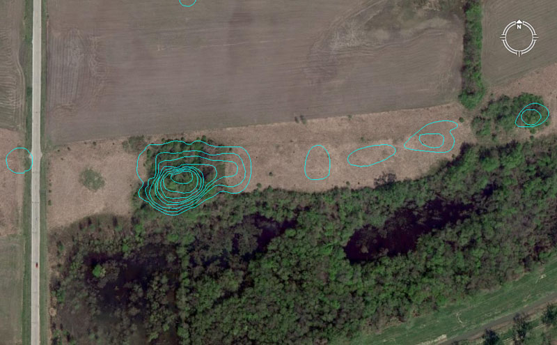
North of Monk's Mound is a set of 7 mounds known as the Kunneman Group, with the largest structure in the group designated as two mounds side-by-side. This batch is numbered as mounds 6-12 on the UWM map.
Mound 6 contains several distance and angle codes across its girth, including 3780' distance from Monk's Mound hub @ 10.66666-degrees (102/3rds). The sum of 3780' equates to 5/8ths of 1-minute of equatorial arc under the Great Pyramid's "6&7" navigational method. The Great Pyramid of Egypt @ 756' per side had a half-side value of 378'. The old French foot was 1.066666" (12.8") and ancient civilisations used many kinds of foot & cubit rules simultaneously, depending upon what kind of calculation the astronomer-mathematicians were doing at any one time. In this vein, there were 3 major types of Egyptian Royal Cubits alone.
Another distance code (tutorial) to Mound 6 was 3750' @ 10.5-degrees. The 375 value generates a mathematical progression much used in navigational and 360-degree compass readings. The sum of 375' is 1/14th of a 5250' mile and the sum of 3.75-degrees is 1/96th of a 360-degree circle.
The 10.5-degree angle sets up yet another mathematical progression that was very exploitable. The ancient Hebrew reed was 10.5' and the sum of 1050' was 1/5th of a Greek mile. In an age where there was no great availability of paper to write books and make them generally available, students memorised numbers (as well as number associations & applications) by grueling rote and repetition exercises. Navigators of the early epochs were required to do quite complex calculations in their heads or with the aid of abacus devices. Training in the manipulation of numbers required a very alert mind.
Another degree angle associated with this mound would have been 10.8-degrees (navigational coding). Note: All decimalised value mentioned here are also simple fractions.
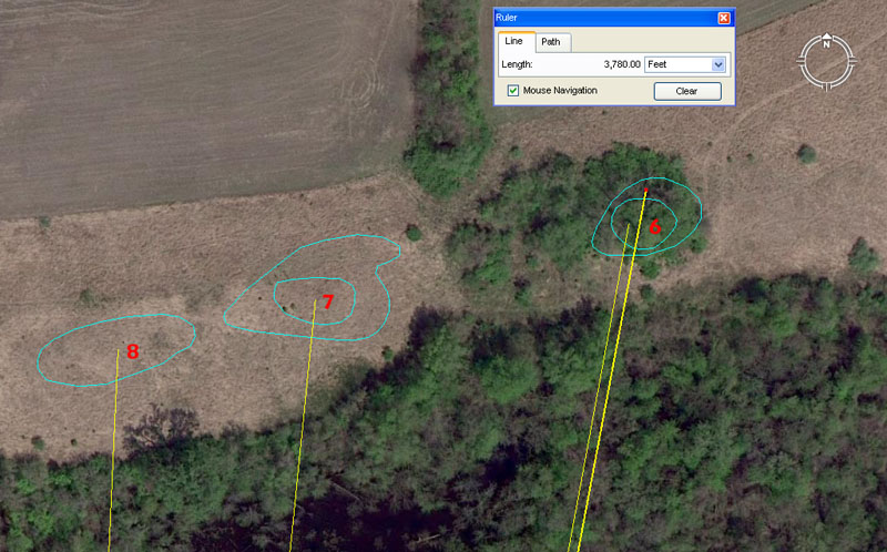
Mound 7 is shown to be 3628.8' from the Monk's Mound hub position @ 5.76-degrees azimuth. The sum of 362880' was 1-degree of arc in a world configured to be 24883.2 Greek miles in circumference. Alternatively, the sum of 363000' would be 1-degree of arc in a world configured to be 24750-miles (of 5280') in equatorial circumference. The 576 mathematical progression generates dynamic numbers used copiously in ancient navigation. There would be 432 (216 X 2) segments of 57.6-miles in the 24883.2-mile equatorial circumference.
Another tutorial would be a reading of 3652.5' resolving upon this mound. There are, of course 365.25-days in the solar year.
A distance reading of 3600' would also be achievable to the northern side of the mound.
Mound 8 sits 3564' from the Monk's Mound hub at an angle of 2.625-degrees.
The 3564 value is navigational, using the "11" family of increments. So, the distance is 5400 links, 648 ancient fathoms, 216 rods or perches, 54 chains, 5.4 furlongs or furrowlongs or .6 of a Scottish mile of 5940'. Note: The centre hub of Big Mound in Old St. Louis sits 35640' (6.75-miles) from the centre hub of Monk's Mound at an azimuth angle of 260-degrees.
The degree angle out from Monk's Mound centre hub is 2.625-degrees (strong lunar and navigational coding). The Greek mile @ 5250' is 2625' X 2.
The return degree angle from mound 8 to the the hub on Monk's Mound is, therefore, 182.625-degrees and the sum of 182.625-days is exactly half of the 365.25-day solar year. Monk's Mound itself appears to lie on an azimuth angle N-S of 182.625-degrees.
Mounds 9 to 12 contain cleverly encoded distances and angles.
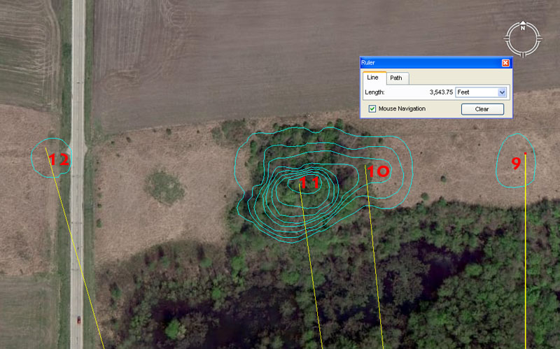
Mound 9 sits due North of Monk's Mound hub at a distance of 3543.75'. For ancient students setting up their manual theodolites (alidade sighting tables and rules) at the fulcrum position of Monk's Mound, then Mound 9 provided orientation onto true North.
The distance value is very dynamic and one of the big numbers of antiquity, related to the 354.375-day lunar year. It is obligatory that this value be found on the large open-air-university sites and at Avebury Henge in Southern England it was cleverly encoded into the distance from the giant obelisk within the Henge to the doorway of West Kennet Longbarrow. The distance in that case was 7087.5' (2 X 3543.75') for a return angle of 354.375-degrees.
Mound 10 at Cahokia sits 3543.75' from the Monk's Mound hub at 354.375-degrees, which so closely parallels the Avebury Henge methodology as to suggest a direct link between the design-architects of both sites.
And in similar fashion, very "in-your-face" coding has been built into the next mound in the lineup:
Mound 11 sits 3520' from the Monk's Mound hub at 352-degrees. The sum of 3520' is 2/3rds of a mile of 5280'. The 352 value sets up a mathematical progression much used in calculations within the "11" navigational system and 352' is 1/15th of an English mile.
Mound 12 sits 3712.5' from Monk's Mound hub at an azimuth angle of 343.75-degrees. This distance at Cahokia is 5/8th of a ancient Scottish mile of 5940' (11 series). The sum of 371.25' would be 1/16th of a Scottish mile.
The 343.75-degrees azimuth angle is coding erlated to the equatorial circumfernce of the Earth under the "11" system of navigation. By that system 1-degree of arc was 68.75-miles or 34.375-miles X 2.
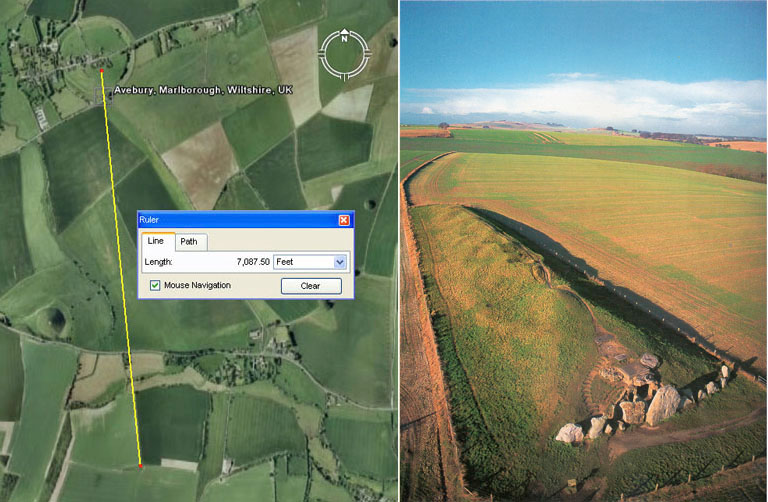
The very important codes related to the lunar year and Khafre Pyramid base dimensions are found in the distance and angle relationship existing between Avebury Henge's centre obelisk position and the doorway into West Kennet longbarrow (Southern England). The distance was set to 7087.5' and the return angle from the doorway to the obelisk was set to 354.375-degrees. Very similar coding was incorporated into positions at Cahokia with the distance and angle between Monk's Mound hub and Mound 10 ... 3543.75' @ 354.375-degrees.