THE BRODGAR OPEN-AIR UNIVERSITY FOR TEACHING NAVIGATION.
The staging area, used by the Megalithic Age-Neolithic Age cousin European nations for voyages to the Americas was, quite obviously, the Orkney and Shetland Islands of Scotland, with the main base being at Scapa Flow of Orkney. Mariners sailing from the Mediterranean or lower latitude Atlantic seaboard countries of Continental Europe could hug the coastline of the British Isles and stay fully in sight of land all the way to Scapa Flow, before venturing on to Iceland. Alternatively, the remote forebears to the Scandinavians or others issuing out of the Baltic Sea into the North Sea, had the option to sail a direct, straight-line route to the Shetland Islands, then to the Faroe Islands, then to Iceland. The much later Vikings had settlements beyond Iceland in Greenland and Newfoundland (L'Anse aux Meadows, adjacent to the St. Lawrence Seaway of North America) and these same locations probably served droves of earlier migrants, over millenniums of time.
The emphasis at Brodgar appears to accentuate navigation to Iceland and, by association, yet further afield to the Americas. Let's now consider this in light of how the Ring o' Brodgar was laid out.

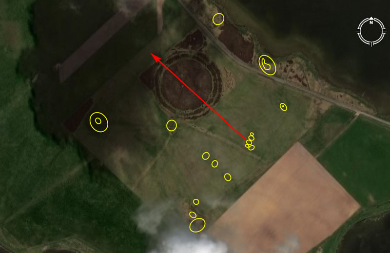
Superimposed over the Google Earth image of the Ring o' Brodgar are the locations of satellite sites associated with the main ring. These include Salt Knowe Mound and several sizable cairns, as well as the tall Comet Stone, situated ESE of Brodgar's centre. Of particular interest is a cluster of 5 closely grouped cairns sitting 525-feet from the centre of Ring o' Brodgar. An arrow running from these cairns passes centrally through the avenue gateways of both the SSE and NNW, while crossing the centre-point of Ring o' Brodgar en route.
The cairn cluster very reasonably approximates the general layout of the Orkney Islands themselves and sit on an azimuth angle that is essentially the same.
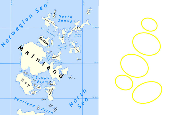
It can be readily seen that the layout of the cairns
is very representative of the geography of the Orkney Islands, with the small,
lower cairn on the left of the cluster representing the very high Island of
Hoy* (as well as associated small islands within Scapa Flow harbour). The
cairns above and to the right are representative of both Mainland and South
Ronaldsay (also incorporating Hunday and Burray). Above the Mainland cairn
is one representing Rousay, as well as the the several islands to the north
and east (Westray, Eday, Sanday and Stronsay). The small upper cairn undoubtedly
represents Papa Westray and North Ronaldsay.
*Footnote: The name "Hoy" means "High" in ancient Scandinavian
and the nautical sayings "Ship Ahoy" or "Land
Ahoy" were seemingly derived from this ... meaning "ship
high" (above the horizon) or "land high" and
coming into view.
The tutorial being given to apprentice navigators from this spot adjacent to the Ring o' Brodgar cairns, however, had far greater meaning than just a simple lesson in local geography. What was being taught here was the scaled distance and azimuth angle for navigating to Iceland from Scapa Flow ... or from the main watercourses and arterial routes in and around the Orkney Islands. Consider the following:
1. The distance from the cairns to the centre of Ring o' Brodgar
is 525' (remember that the British Standard inch and foot have been in continuous
usage since the Megalithic Age and before). In more modern history (age of
the Greek civilisation) the distance of 525' was a "short stadia"
and 5250' was a Greek mile* (based upon progressions of the numbers 6&7
combined).
*Footnote: Examples of the so-called "Greek-mile"
are found marked into the ground around Avebury Henge in Southern England,
as elsewhere, and the distance increment existed for several thousand years
before there was a Greek civilisation.
2. The closest distance from the Orkney Islands to Iceland's SE coast is, essentially, 525-miles (of 5280' each ... this is the British Standard mile, based upon progressions of the number 11). Therefore, the distance (and angle) to Iceland is "scaled" into the ground at Brodgar in a ratio of 1-foot = 1-mile.
3. By remembering any of the standard values in ancient usage to describe PI (3.14159 to 1) the navigator had sufficient information to hit Iceland from the Orkney Islands. There were several, slightly different PI renditions in common usage for various kinds of calculations ... such as 3.125, 3.1416, 1728/550 (3.141818182), 22/7 (3.142857143) or 3.15. The navigator would then multiply any of these variations X 100 and use that angle (say, 315-degrees) as the heading when leaving Scapa Flow via Hoy Sound and proceeding NW to Iceland.
Although any of the aforementioned renditions of PI (X 100), used as the lay line, would land one onto the SE coast of Iceland, the requirement of most navigators would be to skirt around the southern coast of the island to its western side. The best angle to accomplish this was 312.5-degrees azimuth and this just happens to be the dissecting angle that runs through the avenues and centre of the Ring o' Brodgar.
From Iceland's southern reaches one had only to sail due East to bump into Greenland, where there were established settlements of the latter era Vikings in the southern reaches at Herjolfsnes and Bratthalid. These settlements were, undoubtedly, established and used at much earlier epochs than that of the Vikings as staging areas for the next leg of the journey to the Americas.
From the Greenland settlements one sets a course of 224-degrees to end up at the settlement at L'Anse aux Meadows in Newfoundland, at the mouth of the Saint Lawrence Seaway. One is now, essentially, in Canada and the entire American Continent can be explored, continuously in sight of land, including inland waterways branching from the Great Lakes, to Ohio, Illinois and even Minnesota, etc., within the (now) Continental United States.
THE DIMENSIONS OF THE RING O' BRODGAR
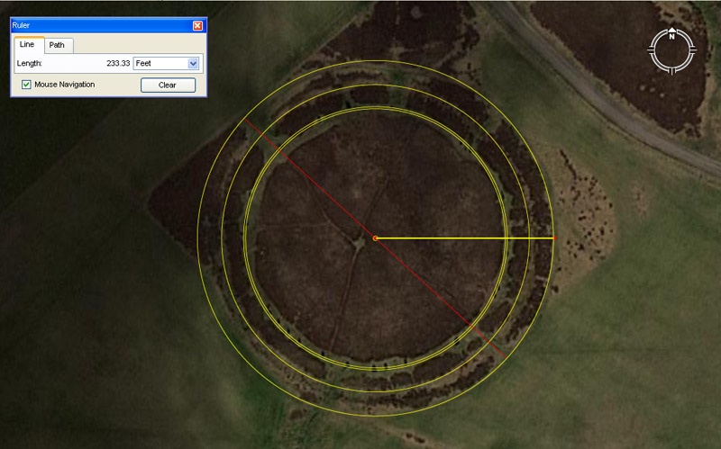
Four sets of concentric circles are seen to be emanating out from Ring o' Brodgar's centre. The two most central ones relate to the subtle differences in the distances of standing stones from site centre. Beyond that is the circuit of the ditch and finally the perimeter extremity circuit of the entire site. A red line extends through the full diameter of the site, dissecting the centre position en route.
It's important to realise that the overall encoded diameter of this site has a direct relationship to Stonehenge, where a marker on the Avenue sits 233.28' (coded or intended design distance reading) from the centre of Stonehenge at an azimuth angle of 45-degrees. In both cases (Brodgar and Stonehenge) the diameter coding relates to the equatorial circumference of the Earth.
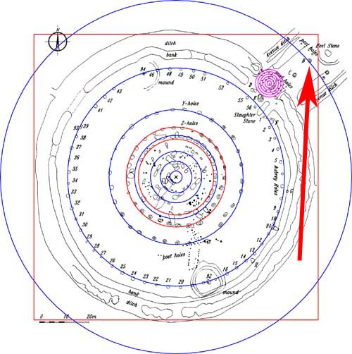
The red arrow points to a marker situated on the Avenue at Stonehenge, which sits 233.28' (also read as 233.3333') from the centre of Stonehenge. From this position the main circles of Stonehenge (with exception to "Z" Holes and the inner rim of the Sarsen Circle ...shown in red) reduce by the PHI ratio of 1: 1.6180339. It can be observed that a half-PHI reduced square overlaying the 466.56 diameter circle contains the Stonehenge site's circular perimeter (378' wide... East to West), with only some Avenue markers (like the Heel Stone) jutting beyond. Therefore, at Stonehenge the PHI reduction (slightly rounded) for the circles go: 466.56' to 288' (Aubrey Circle) to 178.2 ("Y" Holes) to 110' (outer rim of the Sarsen Circle). Each of these numbers is highly coded and factorable and recur in ancient European/Mediterranean Weights, Measures & Volumes standards. The slightly rounded PHI reducing numbers can also be represented as 466 - 288 = 178; 288 - 178 = 110.
Although the Ring o' Brodgar is built to a somewhat different design to Stonehenge, there are inbuilt mathematical codes that home in on the same navigational numbers. An example of this would be, not only the 233.28 radius code, but a half PHI reduction of the same, which goes: 466.56' (diameter) X half-PHI = 378' (slightly rounded).
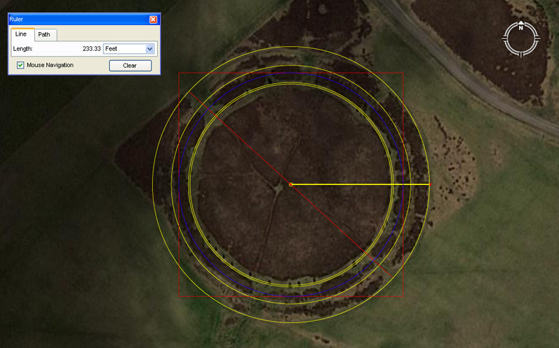
The red square shown is a half-PHI reduction of the 466.56' coded diameter of the Ring o' Brodgar's overall intended diameter and both the square and blue circle it contains comply to widths of 378'. The blue circle represents the edge of the verge or embankment beyond the standing stones and 378' is exactly 1/2 of the design length of the Great Pyramid of Egypt. It is also the East to West width of Stonehenge.
So, why did the architects of Ring o' Brodgar wish to incorporate these diameter values into the structure?
It all has to do with teaching one of the two ancient navigational methods in common usage to grid reference the Earth mathematically for successful and precise positional plotting at sea. Let's explore the method, which was encoded into the base dimensions of the Great Pyramid of Egypt.
1. The Great Pyramid is 756' long (378' X 2). If one circumnavigates the entire pyramid twice, the distance traveled is 6048'. This value represented 1-minute of arc for the equatorial circumference. In other words, 6048' X 60 = 1-degree of arc (362880') and this value X 360 = (130636800') for the entire equatorial circumference.
2. Another way of saying this was 12 X 12 X 12 X 12 X 1.2-miles = 24883.2-miles. When these miles are set to 5250-feet each (the so-called Greek mile) then that value is 130636800'. This was the navigational system that used the "6" & "7" number families combined and the Greek mile or array of associated incremental values are all divisible by either 6 or 7.
3. The sum of 130636800' ÷ 466.56' = 28000. In other words, the overall diameter of the Ring o' Brodgar site represents 1/28000th of the equatorial circumference of the Earth under that navigational system.
This same cross-site diameter translates to 270 of the largest Egyptian Royal cubits detected by Petrie of 20.736". As a consequence, the 130636800' circumference of the Earth also equates to 75600000 of that same Royal Cubit of 20.736" (or 1.728'). It's of interest to note that a cubic foot equates to 1728 cubic inches).
A VASTLY DIFFERENT WORLD.
So, at this juncture the reader might be wondering why we're talking here about British standard "feet" of 12-inches, Egyptian "Royal Cubits" of 20.736-inches and Greek "miles" of 5250-feet ... all lumped in together over the Orkney site. The fact of the matter is that the inter cooperating, ancient cousin European-Mediterranean nations-civilisations (whether in Continental Europe and Asia or around Mediterranean seaboard countries, etc.) were all using the full array of number families for their calculations. They all shared a standardised, integrated mathematical system of measurements, based upon the selfsame inch. All feet, cubits, miles, etc., of all the cousin nations, were derived from the same shared package and all measurements were in direct ratio with each other. European-Caucasoid peoples were scattered all along the Mediterranean coastline of North Africa to Egypt and Mesopotamia, etc., as well as Continental Europe, the British Isles and extending into pockets of Asia and India, as well as other continents (the Americas) or throughout the vastness of the Pacific (Easter Island to New Zealand, etc.).
As we proceed at the Orkney Island sites, further clear examples of British Standard miles of 5280' or so-called Greek miles of 5250' will be shown marked into the landscape, (long before there was such a thing as a Greek civilisation) ... the world was a vastly different place, utterly incomparable in terms of national demographics and ethnic distributions to what we see in countries of today. Compelling evidence shows that the pyramids and temples of the Giza Plateau of Egypt were built much earlier than supposed and represented (by their dimensions and angles, internally and externally) a central Bureau of Standards for all Weights, Measures & Volumes to a confederation of cousin nations in remote antiquity. During this study of the Ring o' Brodgar and its many outlying, satellite sites, there will be constant reference back to measurements and angles encoded into the structures of the Giza Plateau, which incremental values or calibrations are also found on ancient structures throughout the world and are preserved within systems of Caucasoid metrology from ancient to modern times.
THE EMBANKMENT & DITCH CIRCLES AT RING O' BRODGAR.
As stated, the selfsame 1/2 PHI reduction occurs in the Ring o' Brodgar geometry as with the Stonehenge design, creating a 378' diameter circle that demarques the edge of the Brodgar embankment or verge exterior to the standing stones. The 378' diameter circle (coloured blue in the above picture) is half the length of the 756' base of the Great Pyramid and represents 1/16th of 1-minute of equatorial arc for the world. This diameter, therefore, is 1/345600th of the distance around the equator. Note: The outer rim of the Sarsen Circle at Stonehenge has a design circumference of 345.6'.
So, again, yet another tutorial on the site relates to the circumference of the Earth, but with an added dimension that reveals yet another navigational system. By using PI @ 22/7ths (3.142857143) the 378' diameter is turned into a circumference of 1188'. This circumference value relates to a second navigational system incorporated (mnemonically at least) into the base dimensions of the Great Pyramid.
1. If the 756' length of the Great Pyramid were elongated a mere 3" (756.25'), then it would no longer comply with the "6&7" families of numbers, but would be elevated to readings within the "11" family. The 9072" (756') length of the edifice would now be interpreted as 9075" or 825 X 11. Under such circumstances, 1-minute of arc would increase from 6048' to 6050' and the full equatorial circumference of the Earth would be read as 6050 X 60 X 360 = 130680000' or 24750-miles of 5280-feet each (British Standard miles). This same reading would equate to 22000 ancient Scottish miles of 5940' (which mile was also based upon the "11" family of numbers). An ancient Scottish mile was merely 1.125 (11/8th) British standard miles, whereas an ancient Irish mile (6720') was 1.28 (17/25ths) Greek miles of 5250'. Under the ancient Irish system the slightly lesser 130636800' (24883.2 Greek miles) reading of the Earth's circumference (6&7 reading) equated to 19440 ancient Irish miles (which mile was also based upon the combined "6&7" families of numbers).
2. Whereas the ancient Britons, Scandinavians and Germanic tribes,
at late eras at least, seemed to prefer using the "11" system for
navigation, the Greeks adopted the literal "6&7" system incorporated
into the Great Pyramid's base dimensions and fashioned their increments accordingly,
supposedly after consultation with Egyptian priests*. Alternatively, they may
well have inherited this system directly from the Sea People, who established
Athens (circa 1200 BC) during the Greek Dark Ages and began the Greek era of
enlightenment. Emerging evidence shows that the Sea People were from "Oceanus"
or the countries bordering the Atlantic and North Sea, including Britain and
Scandinavia. Their gods included Zeus & Athena (Celtic gods), who they implanted
into Greece.
*Footnote: The recent DNA analysis done on Tutankhamun's mummy,
as well as his parents, shows that the boy king of Egypt (circa 1350 BC) was
of Nordic European origin.
The ditch circle at Ring o' Brodgar seems to carry the coded
diameter of 403.2-feet at its epicentre and this is also a strong navigational
value. This distance from ditch trough to ditch trough would equate to 1/324000th
of the 24883.2-Greek mile equatorial circumference. Under the Great Pyramid's
literal system, where 6048' = 1-minute of arc for the equatorial circumference
of the Earth, the sum of 100.8'* = 1-second of arc. In other words, 100.8'
X 60 X 60 X 360 = 130636800' (or 12 X 12 X 12 X 12 X 1.2 Greek miles or 24883.2-miles
of 5250' each). This diameter at Ring o' Brodgar is, therefore, 4-seconds
of arc for the world (100.8' X 4 = 403.2').
*Footnote: One of the cross measures of the inner rim of
the very slightly elliptical Sarsen Circle at Stonehenge equates to 100.8',
or 1-second of equatorial arc, based upon the Great Pyramid's literal navigation
system.
All of these values are found copiously within British sites, like in and around Avebury Henge or Durrington Walls Henge ... and their purpose-placed satellite mounds situated up to several miles from the henge hubstone positions. The same will be shown to be true in the relationship between Ring o' Brodgar's centre and purpose built outer markers (chambered mounds, brocks, standing stones, or significant landmarks, etc.), set miles away.
THE RING OF STANDING STONES AND POSITIONS OF THE AVENUES.
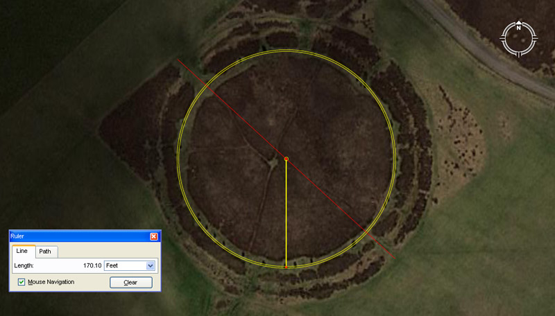
In the above picture, faint yellow circles show the positions of the surviving standing or recumbent stones of the Ring o' Brodgar and a red line passes through the centre of the Avenues dissecting the entire ring from NNW to SSE.
The standing stones best comply to a circle that is coded to be 340.2' in diameter or 170.1' radius, as shown on the Google Earth panel. There is some minor variation to this, with some stones standing at a radius of as little as 166.6666' or as much as 172.8'. Each remnant position is carefully coded as to distance and angle and all positions are both readily decipherable and understandable.
The predominant 170.1' radius - 340.2' diameter is lunar coding and relates to the 6804-day lunar nutation cycle (3402-days X 2 or 1701-days X 4). All of the essential lunar numbers used by ancient navigators for cyclic-astronomical calculations are found encoded into the dimensions of the Khafre Pyramid of the Giza Plateau (Egypt's pyramid of the Moon). The exact same 340.2' diameter code of the Ring o' Brodgar is built into the diameter of the southern circle at Avebury Henge, which is the exact same dimension.
This is how one locates the lunar numbers mathematically and recognises them, by first going back to the Giza Plateau Bureau of Standards:

The Khafre Pyramid of the Giza Plateau (blue) is 15/16ths the base length of the Great Pyramid (yellow). Therefore: 756' ÷ 16 = 47.25' X 15 = 708.75'. Half of the Khafre Pyramid's base length is 354.375' and the length of the lunar year (about 11-days shorter than the solar year) is 354.375-days. The centre of the Ring o' Brodgar sits at an azimuth angle of 35.4375-degrees (357/16ths) from the "V" trough between the two large hills at Hoy Island (Ward & Cuilags). This "V" trough also marks the position of the setting sun at the Winter Solstice, as viewed from the centre of Ring o' Brodgar.
1. Whereas the Great Pyramid, in its base length and slope angle (51.84-degrees), accentuates the mathematical principles related to the size of the Earth and how to grid reference the Earth for successful navigation, the Khafre Pyramid is all about the Moon.
2. The Khafre Pyramid has a design slope angle of 53.13010235-degrees and this angle occurs naturally in all 3-4-5 triangles. Therefore, half the base length is 354.375' (lunar year coding), the vertical height was designed to be 472.5' (11/3rd lunar years coding), and the length of the sloping face was designed to be 590.625' (12/3rds lunar years coding).
3. With each base length of the pyramid equating to 708.75', a full circumnavigation was 2835' or 34020". This value gave mnemonic reference to the 6804-day lunar nutation cycle, the half value of which was 3402-days.
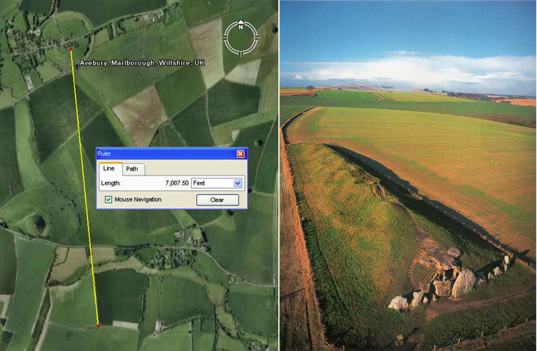
The very important codes related to the lunar year and Khafre Pyramid base dimensions are found in the distance and angle relationship existing between Avebury Henge's centre obelisk position and the doorway into West Kennet longbarrow (Southern England). The distance was set to 7087.5' and the return angle from the doorway to the obelisk was set to 354.375-degrees. This same kind of distance and angle coding exists between the centre of Ring o' Brodgar and hundreds of outlying markers, such as to the Maeshowe or Skara Brae chambered mounds, etc.
THE CODE-BEARING ANGLE THROUGH THE BRODGAR AVENUES.
In an above picture of the Ring o' Brodgar the red vector is seen to the Avenue gate at the SE, dissect the entire ring through its centre, then exit through the NW gate.
The angle runs at 312.5-degrees and the 3.125 to 1 ratio was often used as a form or expression of PI (3.14159 to 1). The ancient British league was 16500' (3.125-miles). If one leaves Scapa Flow on a bearing of 312.5-degrees, that lay-line will get one to Iceland. Of course the opposite is also true and the degree angle from Iceland to the Orkney Islands is 132.5-degrees (180-degrees opposed).
Tutorials based upon this coded avenue dissection would have included all of the standard forms of PI used to achieve perfect circumference readings when calculating within certain number families. For example: If one travels 1 Greek mile of 5250', that converts to a circumference of 1 British league (16500') when using PI @ 22/7ths. Such mathematical manipulation was highly important when doing angle calculations at sea, after traveling straight-line legs based upon Greek miles.
Continue.