THE CODES OF AVEBURY HENGE
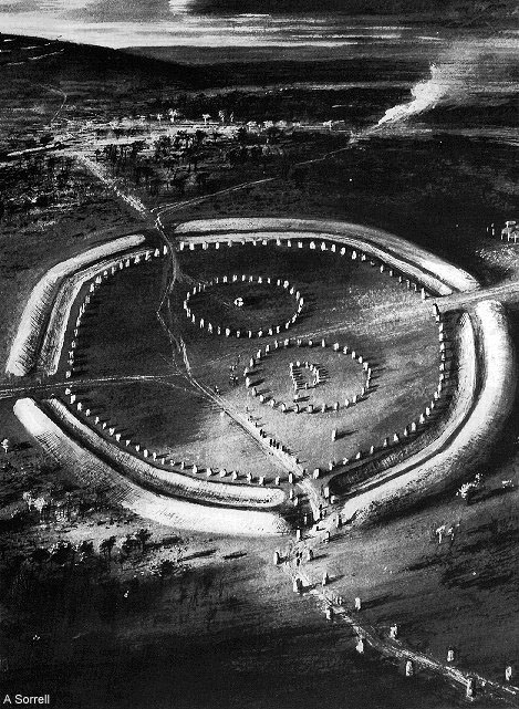
About 5000-years ago a very ambitious project was initiated in Southern England, involving potentially thousands of workers. The task was to build Avebury Henge, as well as several hundred appendage structures in the nearby outer landscape that related geometrically back to the henge's central, tall obelisk. This undertaking, which also included the building of a massive artificial, hill that achieved 130-feet of height and a base diameter of 550-feet, would have required the longterm commitment of a huge support infrastructure. There was the need for constant supplies of food and clothing flowing in from the surrounding farming population to support the mammoth effort. The henge complex alone, which included internal stone markers averaging about 40-tons each, is estimated to have taken 1.5-million man hours to build. Within the henge there were originally about 100 huge obelisk markers in the three main rings and one survivor weighs 100-tons. In the outer landscape over 220 barrow marker mounds were built that had a surveying relationship back to Avebury Henge or to the crown of Silbury Hill.
Avebury Henge remained largely intact until about the 14th century, when zealous Christians began systematically destroying the stones because they considered the "Pagan" site to have been a place of former devil worship. Other opportunists simply wanted to plunder stone for building purposes and felt no remorse in breaking up and pilfering the stone markers from the henge. Thankfully, early antiquarians like John Aubrey (1600's) and William Stukely (1700's) visited the site and documented what was left of the ravaged henge during their respective eras. Their early descriptions, including detailed drawings, have been an invaluable source of information in our understanding of the site, leading to its partial archaeological restoration. Many empty holes or ground depression troughs where stones once stood are now marked by concrete plinths. We may never know the exact girth of many stones (an important factor to analysis) but at least we know the standing positions of many now missing former components.
Alexander Keiller purchased the site in the 1930's then set about cleaning out the henge ditches and re-erecting many fallen stones. By consulting A. C. Smith's survey of 1881, one can see that there remain 18 buried stones on the eastern side of the site that Keiller did not re-erect during his restoration project. Smith exposed all of these, plus some others towards the centre or western sector, but then covered them over again after measuring them.
SO WHY DID OUR ANCIENT ENGLISH ANCESTORS BUILD THIS HUGE COMPLEX?
In reference to nearby Stonehenge (20-miles south of Avebury Henge), our scholars state:
"Most of what has been written about Stonehenge is nonsense or speculation," said R.J.C. Atkinson, archaeologist from University College, Cardiff. "No one will ever have a clue what its significance was"(See Encyclopaedia Britannica, 1994-1999 edition, Article on Stonehenge).
This was recently reiterated again by David Batchelor, an archaeologist with English Heritage, who said, "The only thing we can know with certainty is that we will never know why they built it. All we are left with is what has survived 5,000 years of time." (See Reuters, Toronto Canada 10th of July 2003...interview response by Batchelor to the Journal of the Royal Society of Medicine article, 2003).
Professor Clive Ruggles said, ...'there is no convincing evidence that, at any stage, constructions at Stonehenge deliberately incorporated a great many precise astronomical alignments or that they served as any sort of computing device to predict eclipses...there is no reason whatsoever to suppose that at any stage the site functioned as an astronomical observatory' (See Hengeworld, by Dr. Mike Pitts, pg. 227).
But it gets even worse:
According to Anthony Perks, a retired professor of obstetrics and gynecology at the University of British Columbia, 'Stonehenge's inner bluestone circle represents the labia minora and the giant outer sarsen stone circle is the labia majora. The altar stone is the clitoris and the open center is the birth canal' (See Stonehenge: a view from medicine... Journal of the Royal Society of Medicine...Great Britain 2003).
To this day the Avebury Henge site continues to be represented by our experts as something very different to what it was built and used for. The huge complex is generally regarded as having been built solely to portray sexual symbolism and as a temple for rites of fertility. Some of our our scholars postulate that the giant central obelisk (measured by Stukely to have been 21' long, with a diameter girth of 8' 9") represented a "phallus". This great skywards pointing pillar is supposed to have, from time to time, cast a shadow on the nearby "vulva" stone ...undoubtedly to the delight of generations of leering, bystander voyeurs of bygone ages, assembled to witness the symbolic/ sacred/ sexual event.
While admitting that fertility-related artefacts such as the carved phallus have been located from England (in such locations as Grimes Graves in Norfolk), all the way to New Zealand at the very ends of the Earth, one's enthusiasm for "fertility" cannot account for the commitment to build such huge sites as Avebury Henge. There had to be a far more profound and essential reason for such an undertaking.
In actual fact, ancient trades-people, architects, engineers, astronomer-mathematician-surveyors, etc., worked to a concise plan in setting up the henge, as well as nearby Silbury Hill and the other 829 structures listed in the NMR database. These outer-henge monuments included 220 Bronze Age barrow mounds.
In response to Professor Richard Atkinson's statement concerning Stonehenge that: "No one will ever have a clue what its significance was"... This can only remain true if the comment is wholly based upon present-day "expert" theories, prejudices and imposed-limitations about the scientific accomplishments of our ancestors. In order to solve the ages-old puzzle of what Avebury Henge (the cathedral) and Stonehenge*1 (the chapel) were built for, one has to do the following:
1. Accept the fact that the ancient people of Britain and Continental Europe had precise, shared, measurement standards and geometric methodologies that were highly scientific. All of the cousin nations used the same, highly factorable numbers. The selfsame "inch" determined the overall length of any particular nation's foot, cubit, reed or mile, etc., but the lengths could then be subdivided into any increments of preference (sevenths, eighths, tenths, elevenths, twelfths, etc., or subdivisions that related to the 'irrational' ratio PHI or the ‘incommensurable’ PI.*2
2. Accept that the ancient systems were based upon the modern day "inch" and "foot" and that all varying expressions of ancient "feet" or "cubits", "miles", etc., used by the cousin Caucasoid nations of antiquity, were in very direct ratio to each other. These inter-relating and trading nations were in possession of a singular and universal, shared system of metrology, which incorporated a wide range of highly specialised, factorable numbers to describe such things as the equatorial size of the Earth, principles of navigation at sea or on land, general principles of surveying and astronomical cycle values for maintaining a highly accurate lunisolar calendar.
3. Accept that, by the time Avebury Henge was built, there was one universal standard, using all of the number families for weights, measures and volumes. These values were shared between the cousin Caucasoid nations, ranging from lands of longterm possession in Northern India to the Middle East to Continental Europe to the Americas and across the ancient Pacific to New Zealand ... over 5,000-years ago.
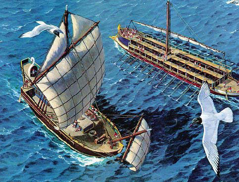
A fact suppressed by the Classicist-Isolationist historians, is that Britain was a very advanced county at the time the Romans invaded Gaul. The Celtic/ Briton/ Gallic navy was formidable and had a legacy of maritime history that linked directly to the Hebrew Phoenicians. For over 1300-years prior to the Roman invasion of Britain, the Celtic/ Phoenician ships had plied trade routes throughout the Mediterranean and Atlantic.
The Celtic/ Britons/ Gallics lost most of their swanships to the Romans at the battle of the Loire Estuary in 56 B.C., due to the wind suddenly dying out at the height of battle. The fast and sturdy sailing ships lay dead in the water, unable to escape the oared vessels of the Romans, which overwhelmed the stranded ships one by one. Despite this terrible reversal for the Gallic-Briton navy, it still took the powerful Romans another 100-years before they could establish a foothold in Britain.
Caesar wrote: '... yet they were very powerful in their navy. They well understood that the Romans neither had any number of ships, nor were acquainted with the shallows, the harbors, or the islands of those parts where they would have to carry on the war; and the navigation was very different in a narrow sea from what it was in the vast and open ocean. Having come to this resolution, they fortify their towns, convey corn into them from the country parts, bring together as many ships as possible to Venetia, where it appeared Caesar would at first carry on the war. They unite to themselves as allies for that war, the Osismii, the Lexovii, the Namnetes, the Ambiliati, the Morini, the Diablintes, and the Menapii; and send for auxiliaries from Britain, which is situated over against those regions.
The influence of this state is by far the most considerable of any of the countries on the whole sea coast, because the Veneti both have a very great number of ships, with which they have been accustomed to sail to Britain, and [thus] excel the rest in their knowledge and experience of nautical affairs; and as only a few ports lie scattered along that stormy and open sea, of which they are in possession, they hold as tributaries almost all those who are accustomed to traffic in that sea...
For their ships were built and equipped after this manner. The keels were somewhat flatter than those of our ships, whereby they could more easily encounter the shallows and the ebbing of the tide: the prows were raised very high, and, in like manner the sterns were adapted to the force of the waves and storms [which they were formed to sustain]. The ships were built wholly of oak, and designed to endure any force and violence whatever; the benches which were made of planks a foot in breadth, were fastened by iron spikes of the thickness of a man's thumb; the anchors were secured fast by iron chains instead of cables, and for sails they used skins and thin dressed leather. These [were used] either through their want of canvas and their ignorance of its application, or for this reason, which is more probable, that they thought that such storms of the ocean, and such violent gales of wind could not be resisted by sails, nor ships of such great burden be conveniently enough managed by them. The encounter of our fleet with these ships' was of such a nature that our fleet excelled in speed alone, and the plying of the oars; other things, considering the nature of the place [and] the violence of the storms, were more suitable and better adapted on their side; for neither could our ships injure theirs with their beaks (so great was their strength), nor on account of their height was a weapon easily cast up to them; and for the same reason they were less readily locked in by rocks. To this was added, that whenever a storm began to rage and they ran before the wind, they both could weather the storm more easily and heave to securely in the shallows, and when left by the tide feared nothing from rocks and shelves: the risk of all which things was much to be dreaded by our ships...
The sail yards [of the enemy], as we have said, being brought down, although two and [in some cases] three ships [of theirs] surrounded each one [of ours], the soldiers strove with the greatest energy to board the ships of the enemy; and, after the barbarians observed this taking place, as a great many of their ships were beaten, and as no relief for that evil could be discovered, they hastened to seek safety in flight. And, having now turned their vessels to that quarter in which the wind blew, so great a calm and lull suddenly arose, that they could not move out of their place, which circumstance, truly, was exceedingly opportune for finishing the business; for our men gave chase and took them one by one, so that very few out of all the number, [and those] by the intervention of night, arrived at the land, after the battle had lasted almost from the fourth hour till sun-set. (The Gallic War (De Bello Gallico) by Caesar, Book III Chapter 13: War with the Veneti. The ships of the Veneti [56 BC]. Translated by Alfred John Church and William Jackson Brodribb).
SO THE PRE-ROMAN BRITISH/ GALLIC PEOPLE HAD ADVANCED SAILING SHIPS...but where did the navigators on these ships receive their training?
Julius Caesar, in describing the Druids of circa 56 B.C., is able to shed light on this question, wherein he wrote:
'They do not think it proper to commit these utterances to writing, although in all other matters and in their public and private accounts they make use of Greek characters. I believe that they have adopted the practice for two reasons- that they do not wish the rule to become common property, nor those who learn the rule to rely on writing and so neglect the cultivation of memory; and, in fact, it does usually happen that the assistance of writing tends to relax the diligence of the student and the action of memory...They also lecture on the stars in their motion, the magnitude of the Earth and its divisions, on natural history, on the power and government of God; and instruct the youth in these subjects' (see De Ballo Gallico, VII, 15, 16.).
The late era Druidic schools that Julius Caesar commented about, undoubtedly, had a pedigree back to similar schools maintained during the Neolithic and Bronze Ages. British historian, Isabel Hill Elder, commenting on the Druidic schools, writes:
'The students at these colleges numbered at times sixty thousand of the youth and young nobility of Britain and Gaul. Caesar comments on the fact that the Gauls sent their youth to Britain to be educated...It required twenty years to master the complete circle of Druidic knowledge. Natural philosophy, astronomy, mathematics, geometry, medicine, jurisprudence, poetry and oratory were all proposed and taught-natural philosophy and astronomy with severe exactitude' (Elder refers to Strabo I IV, page 197. Caesars Comm. Lib V. Sueotonius, V Calegula. E. Campion, Accounts of Ireland, pg. 18.).
When the Roman armies finally managed to get a foothold in Britain they had their own historians in attendance with them. These individuals observed and wrote about the great abundance and variety of goods within the marketplaces and fields, as well as the advanced abilities of British artisans to fabricate such items as enamelware. They noted that each large city, of which there were about sixty in Roman occupied Britain, had its own university. They also mentioned that there were about forty Druidic schools (open air universities using the standing stone and henge sites) and it eventually became common practice for the Roman aristocracy to send their children to Britain for an education.
The Roman governor of Judea, Pontius Pilate, was originally from Iberia (Spain) and after receiving the most advanced education in architecture possible in his home country, had gone to Britain to study there. In the Biblical account of Christ before Pontius Pilate it says, 'Pilate saith unto him, what is truth?' (John 18: 38)...This would seem to support the fact that Pilate had, indeed, received a Druidic education, as the motto of the Druids was "The truth against the world" and the common question posed by the Druids was, "what is truth?" The French word "droit" (right...straight or not crooked, law, governing code) would seem to be a derivative of the earlier word "druid".
If our experts could abandon their limited pre-conceptions about our ancestors and revert to "the scientific approach" when studying Avebury Henge or any of the multitude of "standing stone circles" found in Britain and elsewhere across several continents, then the sites would surrender the scientific information encoded into them without undue difficulty.
In the following analysis the values will be given in fractions, which would undoubtedly have been the way that the numbers were used, manipulated and calculated by the ancient mathematicians. The values will also be shown as whole numbers and decimal tails in order for the reseacher to see what the complete number combination actually was or looked like. For example: the whole number 248832 will be represented as 24883.2; similarly the number 25920 might be shown as 25.92 or 259.2, etc., but it's very important to realise that any decimal "tails" shown are always simple fractions. The ancient mathematicians could, with ease, manipulate and calculate any of these highly factorable numbers, either by mental arithmetic or by the use of counting boards and abacus devices.
LET'S BEGIN!
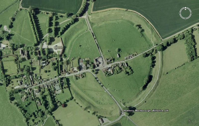
A satellite photo of Avebury Henge. Google Earth works to an accurate algorithm that provides precise measurements within the site or out to the highly visible barrow mounds, etc., in the surrounding landscape. Google Earth, used in conjunction with AutoCAD, provides the essential tools to complete this analysis with confidence.
Also being referred to in this study is a huge electronic map of the henge, its component positions and outlying archaeological structures. This was provided by English Heritage and shows the coordinates of additional positions that cannot be detected on Google Earth (buried obelisks, stones lying under bush overgrowth, etc.). Professor Alexander Thom's accurate on-site survey (circa mid 1970's) and some more recent finds commented about and recorded by Dr. Mike Pitts, etc., are also consulted.
For the moment we'll assess what's visually apparent on the ground, marked by surviving stones or concrete plinths. Later, we can add in the (reburied) stones found by Smith in 1881-82 or any others identified as being there in the archaeological records of English Heritage.
THE ESSENTIAL NUMBERS, ENCODED AT AVEBURY, THAT HAD TO BE REMEMBERED AND HANDED ON INTACT TO EACH GENERATION.
The finalised, big numbers that had to be remembered by ancient civillised society might look reasonably unfriendly. This is because nature has a bad habit of running cycles to its own schedule, without consulting accountants. A solar year is 365.2422-days and a lunar year is 354.3643519-days. The lunar nutation cycle, where the moon goes to a position called major standstill, returns to minor standstill, then returns to major standstill again, takes 6798.36-days or 18.61329277 solar years. The Earth is 24902.44523-miles in equatorial circumference. The polar circumference is 24816.55084-miles. The cycle of the Precession of the Equinoxes takes 25776-years to complete.
So, with these horrible numbers to contend with, provided that at some stage one's sciences and generations of careful observation have produced the near values to these numbers, how do scientists turn this chaotic set of difficult values into an ordered, integrated and functional mathematical system?