THE WINTER SOLSTICE OBSERVATIONS FOR NEW ZEALAND 2019.
The Hauraki Gulf of Auckland, New Zealand could easily be compared in beauty to the Cote d’Azure of the French Riviera, both locations offering long beach coastlines and offshore islands. In ancient times and up until the present these gems have offered idyllic living conditions for those lucky enough to call them home.
The many large and small islands of the Hauraki Gulf provide leeward protection from raging storms and there are abundant offshore fish resources or rich beds of shellfish on beach shorelines at low tide.
The Hauraki Gulf, set in a temperate climate and covering 4000 square kilometres of ocean, large and small islands, harbours or coastal beaches. Because of the enclosing topography, the inner gulf is quite protected from the storms of the open sea by the Coromandel Peninsula, Great Barrier Island and other sizeable ones including Waiheke, Motutapu and Rangitoto volcano.
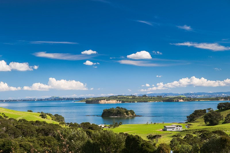
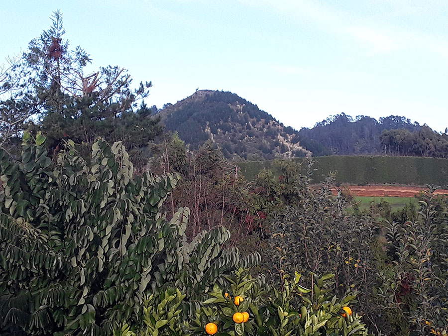
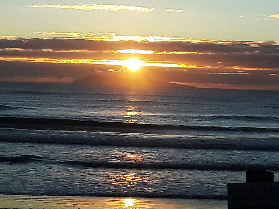
One stretch of this east facing coastline was at Narrow Neck Beach, which features in archaeological reports as a place of long-term ancient habitation by pre-colonial peoples.
Narrow Neck Beach, showing expansive, extinct or dormant Rangitoto Island in the background. Rangitoto’s central volcanic cone represented the outer marker for precise fixes onto the winter solstice sunrise from the mainland. Likewise, the centre cone of Rangitoto was the outer marker for the summer solstice sunrise for people living up the coast at Mairangi Bay, 9.5 kilometres NNW.
THE WINTER SOLSTICE SUN RISING FROM RANGITOTO VOLCANO … From the observer's position at Narrow Neck Beach cliffs.
Although the observer's obelisk, cairn or mound on the Narrow Neck cliff can no longer be identified due to colonial-era excavations to make a naval base, we know from archaeological records that the wide, flat area above the beach was anciently occupied. We also know that the ancient sun-worshipper people, wherever possible, used extinct, dormant or active volcanoes around New Zealand as the outer-markers for solstice or equinox rise and set fixes. This is evident at many locations, where the original position for the observer to stand is still marked by an obelisk, cairn, mound, sighting-pit or aligned-trench.
MAYOR ISLAND & PUKETOKI HILL, WAIHI BEACH.
At a distance of 125-kilometres to the SSW is Waihi Beach in the Bay of Plenty Province where ancient people were using yet another extinct/ dormant island volcano as a winter solstice outer-marker. This one is called Mayor Island and legends abounds about the ancient people who occupied the region for thousands of years before the 1300 AD coming of the warrior Maori.
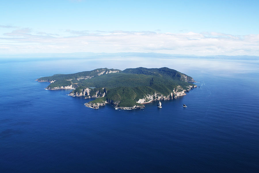
Again, Mayor Island with its blown-out rim circumnavigating the depressed inner cavity of the once fiery centre, was a large volcanic island like Rangitoto. As at Narrow Neck Beach or Mairangi Bay in the Auckland Isthmus, ancient people at Waihi Beach were visually returning sun-fire to the heart of the volcano once a year for keeping their calendar count true.
For many generations the ancient inhabitants of Mayor Island mined and traded obsidian (volcanic glass) with other groups across the length and breadth of New Zealand. Obsidian was much sought after for making very sharp cutting instruments, useful in filleting fish, etc. This island was, seemingly, the primary or best known resource for the entire country.
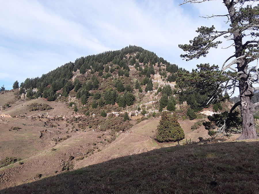
Inland from the Waihi Beach coastline was a hill that had been carefully modified at its summit as a solar observatory. Again, it functioned to get a very refined fix onto the winter solstice sunrise out of Mayor Island’s cone. This observatory was on the highest point of Puketoki Hill.
Puketoki Hill, with its anciently modified summit, looms above the kiwi-fruit growing belt of Waihi Beach township. From its highest point, the ancient Patu-paiarehe people took annual fixes onto the winter solstice sunrise position of Mayor Island (elevation 293 metres) targeting the highest point of the island. From the observatory on Puketoki Hill (249 metres) the angle to the sunrise on Mayor Island was 60.03-degrees.
The final approach to Puketoki Hill on the day of the winter solstice for New Zealand, 22nd of June 2019. The last part of the climb up through steep bush was quite challenging.
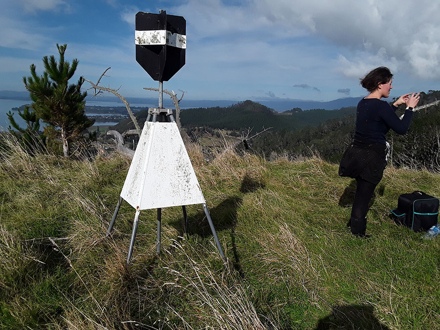
The trig tower sits upon an ancient square cut plateau and provided the observatory position for witnessing the winter solstice sunrise from the centre crater of Mayor Island, with "first glint" occuring at 60.03-degrees azimuth.
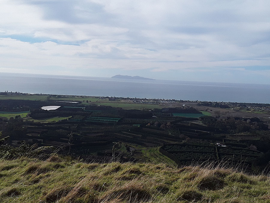
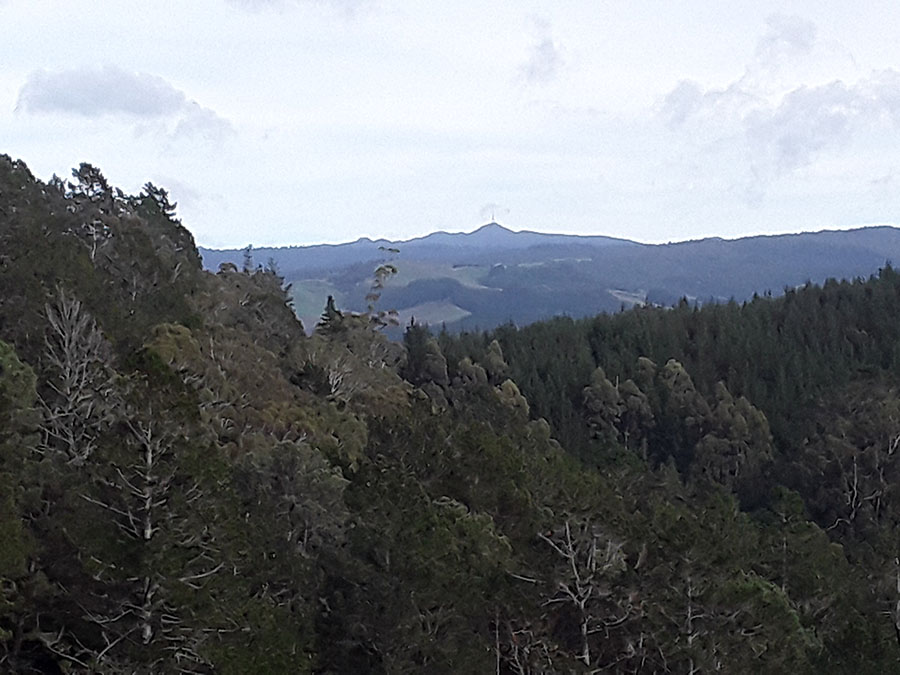
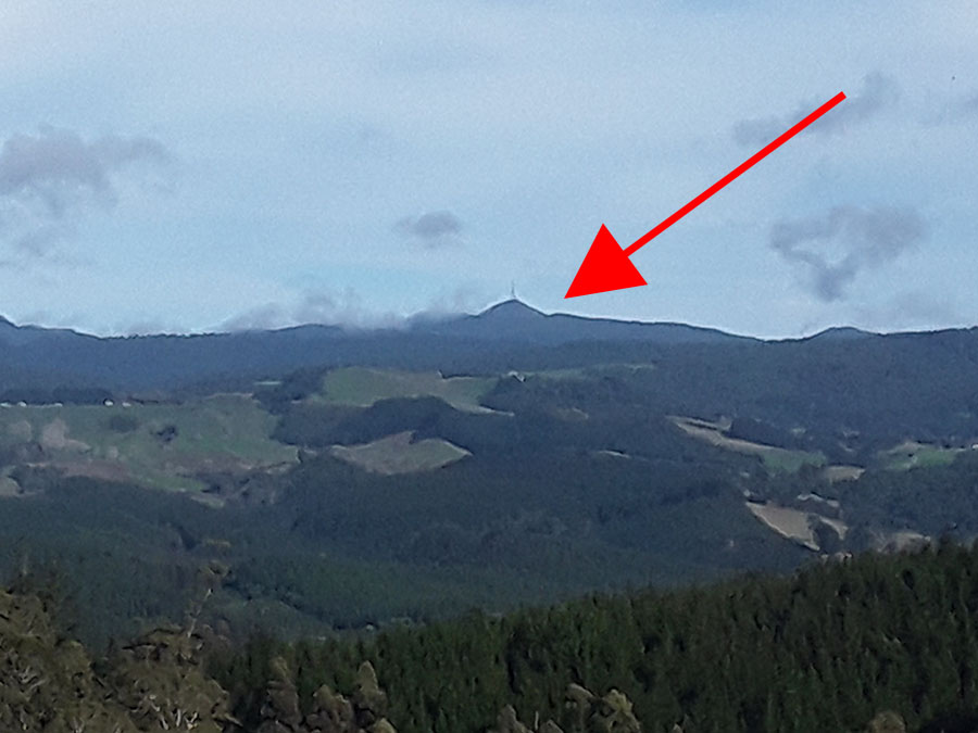
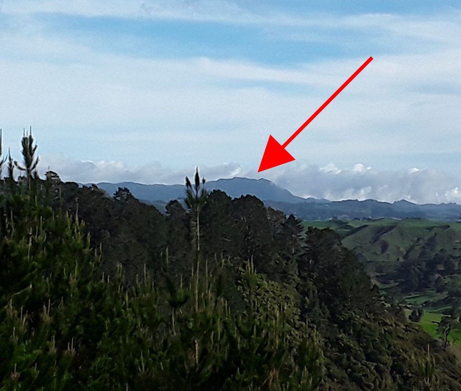
The slightly faded outline of Mayor Island, 34.5 kilometres distant, is visible through the midday mist. First glint of the sun occurs on the highest point just south of the centre, with the full orb of the diagonally rising sun emerging from the dip. This gave the observers atop Puketoki a finite fix on the winter solstice day.
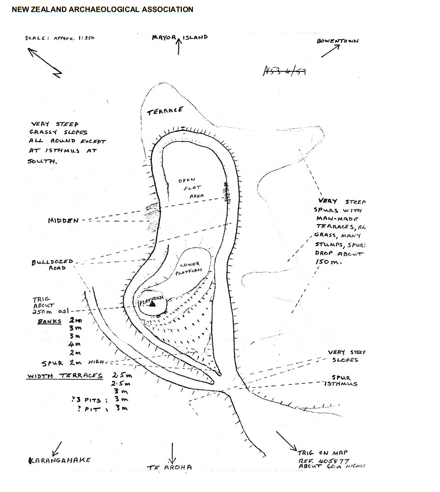
An archaeological map shows extensive, ancient excavations that were done at the top of Puketoki Hill and terracing to the sides. There are also more modern disturbances by forestry bulldozers forming tracks for the removal of logs, but such damage has not encroached markedly into the anciently dug plateaus. The forestry roads are now severely overgrown and mostly impassable, but the hill summit remains clear of scrub, affording spectacular views through 360-degrees.
Photograph taken of the winter solstice sunrise on the cloud-covered top of Mayor island from Waihi Beach shoreline. The view from the elevated top of Puketoki Hill would have been very similar to this, as calculated in the astronomy program Red Shift.
Unsurprisingly, this position, from whence the photo of the winter solstice sunrise on Mayor Island was taken, was once a very ancient settlement of the Ngamarama people, whose village settlement lay right-on-the-line for observing the winter solstice sunrise emerging from the cone of Mayor Island volcano.
Prominent & famous New Zealander of the 19th and early 20th centuries, Gilbert Mair, recorded the following archaeological discovery at Waihi Beach shoreline of circa 1892:
Art. XIX.—Chips from an Ancient Maori Workshop, by Captain G. Mair.
[Read before the Auckland Institute, 4th August, 1902.]
On the shores of Tauranga Harbour, near Katikati, there used to be a long sandy ridge about 40 ft. above sea-level, covered with such plants as love the seaside. This place was known by the name of Waiorooro (the waters of grinding or rubbing). Struck by the singular inappropriateness of this name, I once asked the late chief Hori Tupaea the reason why it was so called. He said the name had come down from prehistoric times; that it had been the home in bygone ages of a numerous tribe, now long forgotten—the Ngamarama.
About ten years ago, owing to the destruction of the vegetation by fire and the trampling of stock, the sandhill began to move seawards before the fierce and prevailing westerly winds, leaving, in a short time, the original surface of clayey soil, and forming a level sort of plateau some chains wide and perhaps 150 yards long, and disclosing the site of an ancient village with numerous middens and workshops. Around the latter cartloads of obsidian, chert, and different kinds of stone knives and flakes could be seen. Heaps of even-sized round stones for net-sinkers and fishing-sinkers, and hundreds of bone implements made from whalebone, human bone, moa, albatross, and native-dog bones could be seen in every stage of manufacture. Barbed points for fish-hooks or bird-spears also strewed the surface. In fact, here were to be found specimens of almost every domestic article used by a primitive people. Here and there were stone platforms or pavements, consisting of flat stones neatly fitted together and set in some kind of cement, apparently made from ashes or burnt shell. These places were circular, about 6 ft. in diameter, and were probably used for roasting or drying food on. The corner posts (of totara) of many of the houses were still standing, but crumbled to brown dust on being touched. None of the huts appeared to have been more than 8 ft. wide and 10 ft. to 12 ft. long. Stone hammers were also very numerous, and so were stone axes, adzes, gouges, wedges, chisels, drill-points, & c. I gathered over two hundred perfect implements, while probably twice that number of broken ones I discarded. There were also several wooden weapons — paddles, spears, & c.—some showing signs of rough carving; but they fell to pieces on being touched, as did most of the bone articles—hooks, & c. — excepting the uhis or tattooing-adzes and beautiful little sewing-needles, which, being made from the fine hard bone of the albatross, are in perfect preservation. I also noticed a number of slabs of a kind of sandstone called “hoanga” by the natives, none of which, so far as I know, is to be found in the neighbourhood of Tauranga, and large smooth stones or anvils. The axes, adzes, & c., are also made from a hard kind of stone not found on the mainland, but probably obtained from Tuhua, or Mayor Island, which is just opposite and about fifteen miles off shore. A number of shafts made from bone, stone, or petrified wood were found. They are evidently the haft or stem of some kind of fish-hook, and probably the link is attached as shown in Plate LI., fig. 2.
I found portions of two rare stone pendants or neck ornaments, something like the unique specimen deposited by Miss Morrison in the Auckland Museum. Some years ago I found one exactly similar near Cape Kidnappers, Hawke's Bay.
Only a few greenstone ornaments or greenstone chips were found, and they are probably of much later date. The manner in which the stone weapons are chipped out is really most artistic, and evidences great skill. The class of weapons are evidently the work of a people in a much lower stage of civilisation, and are not highly polished and like those used by the Hawaikians, or ancestors of the present Maoris. Many of the axes and adzes had been fitted with wooden handles, and even the binding of kiekie-roots lay in spirals round the wood and stone, but was quite perished, and the wood crumbled at the lightest touch.
Not the least interesting of my discoveries was finding the tiny model of an ancient pa tiwatawata, or palisaded fort, which had evidently been a plaything of the village children. It had been made by sticking three rows of totara splinters into the ground, forming the three lines of defence known as the Pekerangi, Kaikirikiri, and Kiri tangata. There were two gateways (waharoa), approached by long alleyways. The model was of this shape, and about 6 ft. by 4 ft.:—
It is evident that these villagers were a tribe of artisans who made weapons and domestic articles for trading purposes. While they were on a prolonged visit to some other place a gale of extraordinary severity must have overwhelmed their kainga, burying it 20 ft. or 30 ft. deep with drifting sand, and now, after a lapse of perhaps hundreds of years, it has been exposed to view. Since I last visited it the sand has again covered the larger portion of the village-site. (See: http://rsnz.natlib.govt.nz/volume/rsnz_35/rsnz_35_00_001550.html ).
The location where a very ancient village was uncovered in circa 1890 - 92. It was situated in such a way that the village (or a precisely placed marker within) represented a solar observatory for getting a precise fix on the winter solstice sunrise as it ascended from the crater of Mayor Island.
Gilbert Mair’s testimony about wood and bone artefacts turning to dust when first exposed and touched is reminiscent of what happened when ancient tumulus mounds were opened-up across Ohio & Pennsylvania, USA, in the 19th century. The oldest human skeletons and wooden artefacts of the mound builders crumbled into dust within a day or so of exposure to oxygen due to being thousands of years old. Some less ancient skeletons remained sufficiently intact to go on display at museums.
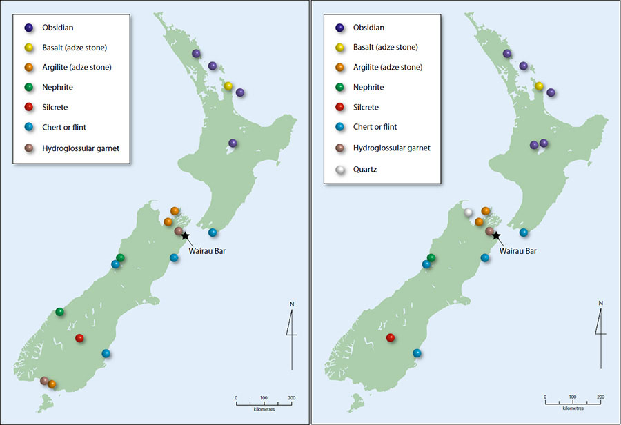
To the left are seen dots representing sources of specialised stone known to have been used as tools, etc, all across New Zealand. These stone resources were carried within exchange networks over hundreds of kilometres and up to 2000 kilometres from their source. To the right is seen the originating locations of specialised stone that came in as trade goods to the centrally located, Wairau Bar community. https://blogs.otago.ac.nz/globalmigration/files/2018/09/Walter-et-al-2017.pdf
Gilbert Mair’s account about stone finds at Waihi Beach lists large quantities of chert stone, which was not available within almost 500-kilometres. Likewise, quality greenstone could not be acquired within a range of about 600 kilometres, but one would have to cross the dangerous Cook Strait sea-lane to the South Island to get it. Several other accounts appearing in early 20th century newspapers attest to the fact that large quantities of raw greenstone were being fashioned into precious objects at Waihi Beach or near vicinity by specialist greenstone carvers. One of their workshops was on the Te Aroha Ranges, about 25-kilometres inland of Waihi Beach. The name Puketoki Hill translates to “Adze Hill”.
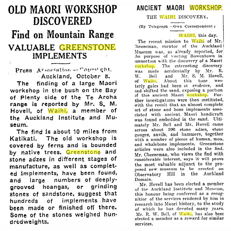
To the left is seen a newspaper article from the Stratford Evening Post, vol. III, issue 171, 9th of October 1934. To the right is an article appearing in the Auckland Star, vol. L, issue 89, 14th of April 1919. A fuller account of the Te Aroha Range find says:
OLD MAORI WORKSHOP LOCATED NEAR KATIKATI
FIND ON MOUNTAIN RANGE GREENSTONE IMPLEMENTS
WAIHI, Friday. The finding of a large Maori workshop in the bush on the Bay of Plenty side of the Te Aroha Range is reported by Mr. S. M. Hovell, of Waihi, a member of the Auckland Institute and Museum. The find is about 10 miles from Katikati. The old workshop is covered by fern and is bounded by native trees. Greenstone and stone adzes in different stages of manufacture, as well as completed implements, have been found, and large numbers of deeply-grooved hoangas, or grinding stones of sandstone, suggest that hundreds of implements have been made or finished off there. Some of the stones weighed hundredweights.
Mr. Hovell states it is unusual for such places to be so far from the sea.
Authorities consulted in Auckland yesterday agreed that the discovery of the workshop is of considerable interest, and many valuable articles should be recovered. The name "workshop" is applied to those localities where the ancient Maori craftsmen, skilled in the fashioning of stone for a variety of purposes, were accustomed to do their work. The best workshops were usually centred in well-defined districts, and the Waihi area, offering as it did a vast quantity of suitable material, was of great importance to the Maoris of old. Some tribes were in a position to develop extensive trade by barter in materials more or less peculiar to their lands, and a well-known case in point was the dealing in greenstone from Westland.
The latest discovery in the To Aroha Ranges is of especial importance, because greenstone has been found in various stages of manufacture. The distance from the sea commented on by Mr. Hovell suggests that the workshop was not an ordinary tribal one, but was operated by several individuals as specialists- who desired to keep away from the centres of activity. Mr. Hovell conducted explorations of the district for some years, and numbers of articles found by him are in the collections in the War Memorial Museum. https://paperspast.natlib.govt.nz/newspapers/NZH19341006.2.105?query=workshop%20waihi&page=5&snippet=true
Gilbert Mair also mentions a particular kind of sandstone that was not obtainable anywhere in the region, which had obviously been hauled in at great effort. At least one newspaper article tells us that these out-of-place blocks could weigh up to several hundredweight (1 CWT = 112-pounds = 50.8 kg). Mair’s account plus several others also mention Moa bones, presumably cooked, but there were not supposed to be any Moa birds available after about 1350 AD, or within 100-years of Maori arriving in New Zealand.
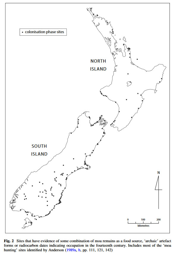
Although Maori are said to have arrived in New Zealand, in small numbers, no earlier than about 1250 AD, they are credited with having wiped out all the Moa birds by about 1350 AD. The above drawing shows the sites where there were sizeable populations of people who cooked and ate Moa birds during the “archaic period” (just prior to 1350 AD). Three of the sites shown include Waihi Beach and even Mayor Island offshore.
A statement accompanying the above article & picture says: ‘Several decades later there is still no convincing direct evidence of humans on the New Zealand landscape any earlier than 1300 AD.’
A further statement in the article says: ‘ … the extinction of moa occurred with astonishing rapidity, in a matter of 80–100 years, not after centuries of relentless human predation.’
The official policy in New Zealand is that there were no humans living in the entire country prior to 1250 AD, when a small group, composed of say 7-people from Eastern Polynesia (including women), washed up on the coast, presumably after a "drift mishap". This denial of former inhabitants is politically-driven and runs contrary to evidence contained within our older history books, Maori oral traditions and a huge body of archaeological evidence, etc. Every find in New Zealand HAS to be attributable to Maori (circa 1300AD to the present).
It doesn't take much mental arithmetic or logic to see that the population model postulated by our academics is ridiculous in the extreme. It goes someting like this:
About 7 Polynesian people find Wairau Bar, New Zealand after a drift mishap (?) in say 1250 AD (Dr. Janet Davidson et al)... about 5-minutes later they discover greenstone at Hokitika (280 kilometres away across rugged, snow-capped mountains & ravines) and know how to carve it ... 5-minutes after that they find high quality basalt rock at Opito Bay (550 kilometres away in the North Island) and start churning out adzes in vast quantity for nationwide distribution ... about 5-minutes after that they've bred up such a sizable population (across a country 1500-kilometres long & larger than the British Isles) as to have decimated all the species of Moa birds throughout New Zealand, have built thousands of huge PA fortresses, villages, canal systems and intensive alluvial plain drain networks of raised garden systems, etc., ... Wow! ... now that's fast-tracking!
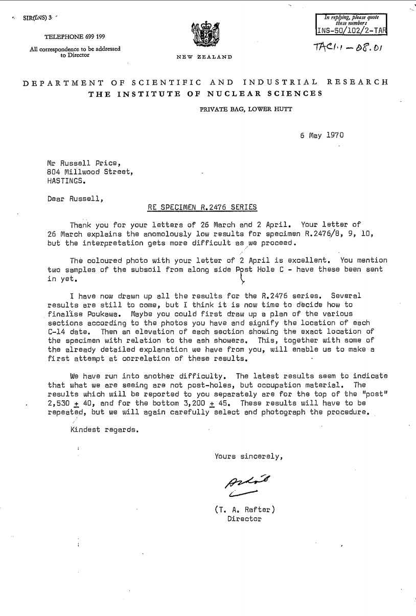
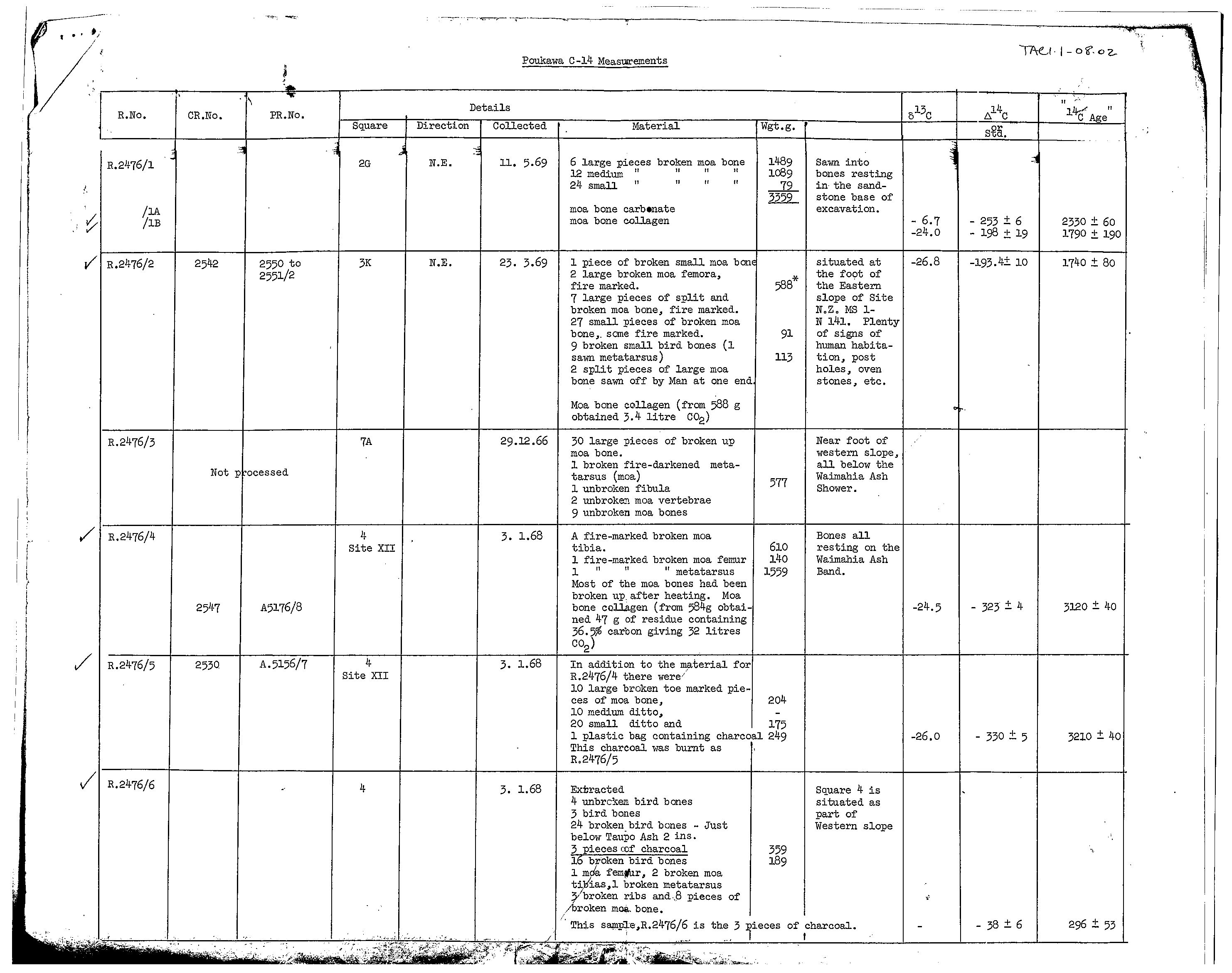
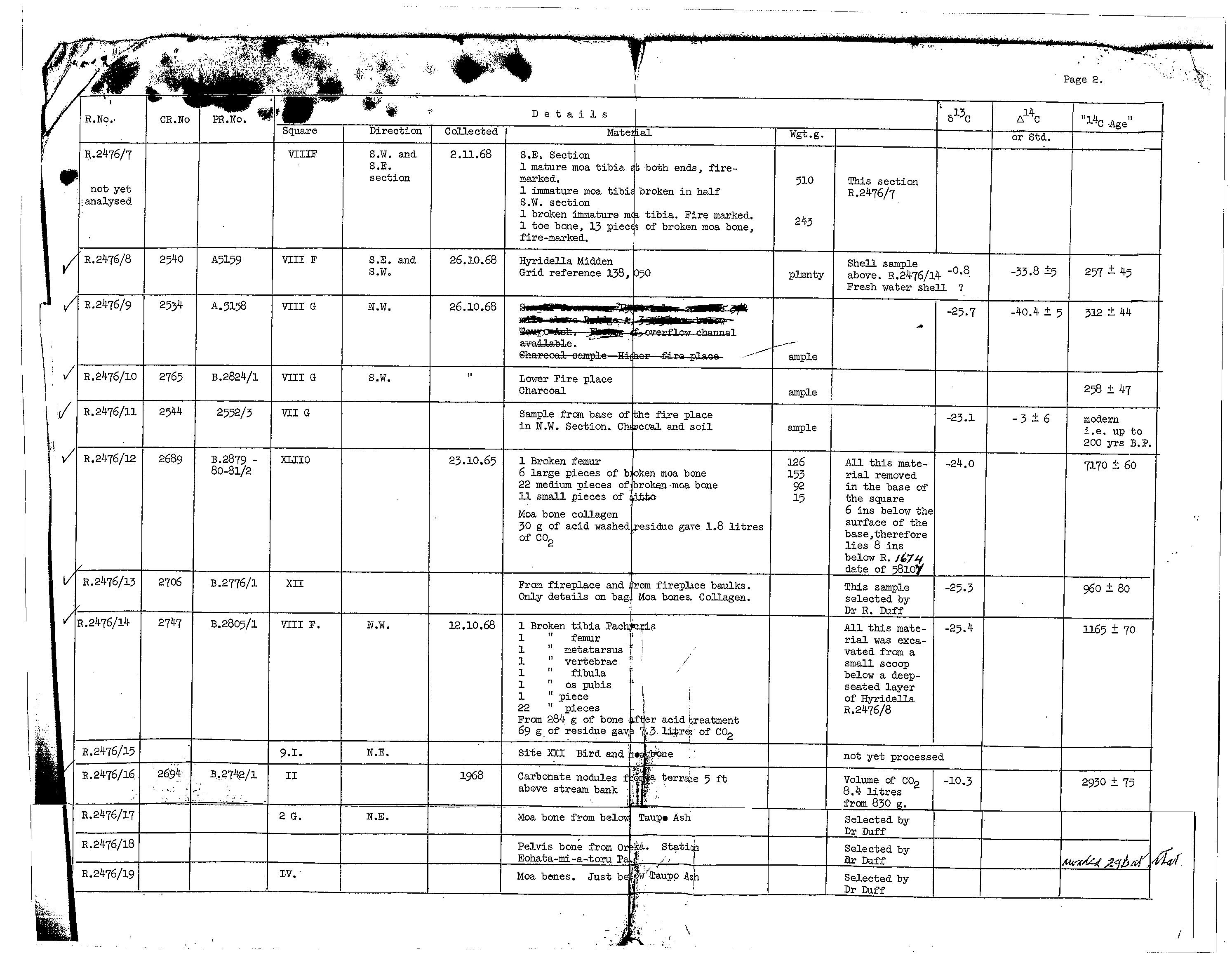
As it turns out carbon dating figures from Poukawa, Hawkes Bay, prove that people were cooking the giant Moa birds, cutting the flesh from the bones and leaving cut or scrape marks in the process, then breaking the bones into smaller sections to extract the marrow … at least 2000 – 3200 years ago, with one result indicating 7170-years ago.
When confronted with these authentic C14 results from the 1960s – 70s dig at Poukawa, the Radiocarbon Laboratory, on 1st of July, 2019 responded with:
‘We have recently re-evaluated and subsequently recalculated and corrected our original data to align with current reporting conventions, as a result of the corrections some sample results can change by several hundred years from the original result.’
Our correspondent, in trying to convince us that the C14 results of the 1970s were unreliable, wrote, ‘some sample results can change by several hundred years from the original result’ but didn't clarify whether or not those ‘several hundred years’ were plus or minus. We took the statement about ‘current reporting conventions’ to mean making/ forcing all reported results to fit the Maori arrival epoch of no earlier than (circa) 1300 AD.
With regards to the Poukawa dig (270-kilometres SSE of Waihi Beach), the C14 results, which have been withheld from the general public for nigh on 50-years, there is a second way available to verify their validity.
Most of the human-made artefacts or signs of human activity found and recorded were under undisturbed ash-band-layers from volcanic explosions, the eruption dates of which were known. For example, the Taupo explosion was in 186 AD (over 1100-years before the 1300 AD arrival of the Polynesian-Melanesian Maori). The Waimahia volcanic explosion and its subsequent ash layer was in 1320 - 1344 BC (circa 3350-years ago) and, again, manmade artefacts or human activity were in evidence below that undisturbed layer (over 2600-years before Maori), etc.
To see these undisputable results of very ancient human occupation of New Zealand, go to the 3 links below and magnify the C14 sample figures for clear reading.
http://celticnz.co.nz/Kaiwhakaruaki/Letter1.jpg
http://celticnz.co.nz/Kaiwhakaruaki/Carbondating2.jpg
http://celticnz.co.nz/Kaiwhakaruaki/Carbondating3.jpg
The Waihi Beach distribution network of artisans, who travelled over vast distances to barter with their wares, accumulated large quantities of raw greenstone from the South Island of New Zealand, which they later fashioned into precious objects. These people were obviously a family of the pre-Maori greenstone folk, the last remnants of which (at Waihi Beach) were the Ngamarama people, later vanquished from the region and history itself by their Maori conquerors.
THE EXCAVATIONS ATOP PUKETOKI HILL & HOW IT FUNCTIONS AS A SOLAR OBSERVATORY.
The much modified top of Puketoki Hill, commanding superb views and linked by a high ridge to yet another carved hilltop 700 metres away to the SW (291 metres high). The original builders of Puketoki were quite obviously a sun-worshipping or sun-venerating people, who very deliberately carved the summit section of the hill to orientate onto the highest point of Mayor Island volcano for “first-glint” of the sun at the time of the winter solstice.
MOUNT TE AROHA TO THE WSW OF PUKETOKI HILL.
A much magnified view of lofty Mount Te Aroha (947 metres) situated to the SW of Puketoki Hill (19 kilometres distant). This was the outer marker from the summit of Puketoki for the summer solstice sunset.
The summer solstice sun would touch down just to the north side of Mount Te Aroha, as observed from the summit of Puketoki Hill and then meld into Te Aroha, to give a refined fix on the summer solstice sunset. The alighting angle would be 238.9-degrees, as calculated in Red Shift astronomy program.
Alternatively, from the observatory position atop Puketoki, the equinox sunset fixes could be done twice a year by watching the sun sink into the northern side of Mount Kangahake.
The equinox sunset into the highest terrain of Kangahake Mountain (543 metres) at an alighting position of 272-degrees.
Once again there is clear evidence that the very ancient shoreline village at Waihi Beach, uncovered in about 1890-92, in conjunction with the inland hill called Puketoki were, due to their very opportune positions, functioning as solar observatories. Both locations were using Mayor Island as their winter solstice sunrise outer-marker. In addition, Puketoki Hill served as a solar observatory for precise fixes onto the summer solstice (Mt Te Aroha) and equinox (Mt. Karangahake) sunsets.
The last remnants of the regional "greenstone folk" were the Ngamarama (The moon people or illuminated/ gleaming ones), also referred to as the "friendly Maoris" in late era oral traditions.
'THE expression “Whanau Marama” [Moon family] was employed by the Maori to denote all the heavenly bodies. It may be rendered as “the Light-giving Family” (or “Offspring”), or “the Children of Light.” When we have scanned the origin of those luminaries we shall know why they were so termed. ... In pre-European times the stars were closely studied by the natives—not by all persons, be it explained, but by a limited number of men of the tohunga (or adept) class, who devoted much time to a study of the ra ririki, or little suns, as they were termed. Such men would often pass long hours of the night in contemplating the stars, and would be looked upon as reliable weather-prophets. Travellers and fishermen would consult them ere venturing forth, and their powers are said to have also enabled them to foretell the general aspect of coming seasons, their fruitfulness or otherwise'.
Such were the studies of the tohunga kokorangi, the Maori astronomer. These men knew well the movements of the stars; they knew when to look for their appearance, and always awaited it, in order to scan closely their aspect. One famed old wise man of the Wairarapa district, of last century, devoted much of his time to studying the stars and planets. His contemporaries have told me that they have often known him to pass the greater part of the night on the summit of a hillock near his hut, gazing continuously at the heavens. Of what was he thinking during the silent watches of the night, as he looked on Matariki and Te Kokota, on the blazing line of Te Kakau, or the curved line of the Canoe of Mairerangi?
(See: The Astronomical Knowledge of the Maori, Genuine and Empirical, by Elsdon Best, Dominion Museum, Wellington, NZ).
Along with line-dancing, fishnet weaving, tattooing, carving, the recounting of memorised histories or myths, as well as the higher knowledge of the wharewaananga (university) Maori learned astronomy from the ancient Patu-paiarehe tribes.
THE LEGEND OF MATAORO & NIWAREKA
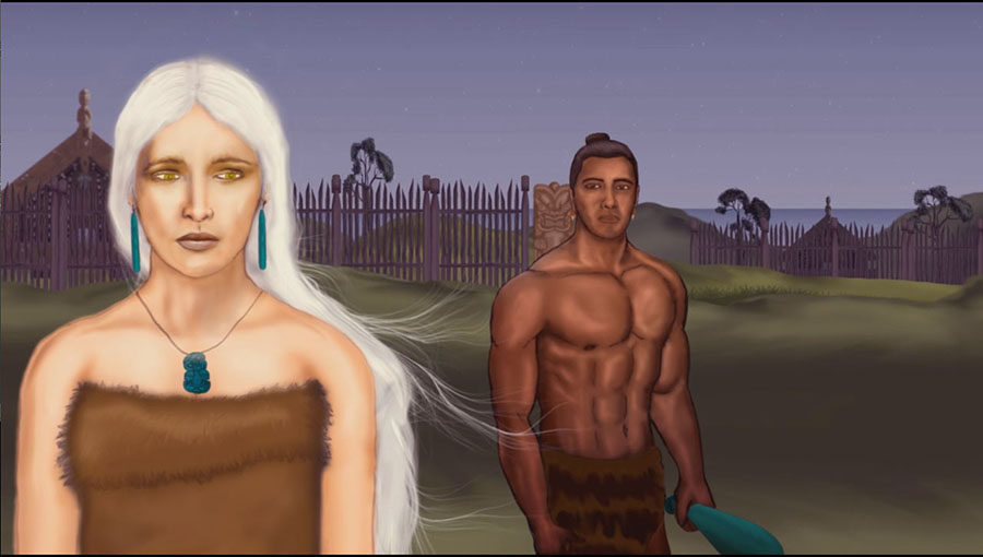
Niwareka, a Turehu woman whose home and people are in the underworld, marries Mataoro, a Maori man, whose home is in the upper world. He beats her and she flees to her home and people, only to be pursued by a remorseful Mataoro, who convinces her to return with him to the upper world. In the underworld Mataoro learns the art of facial tattooing from Niwareka’s father, which he brings back to the upper world. Other parts of the story infer that line dancing and intricate cloak weaving were taught to Maori by the Turehu, who also taught Maori how to weave fishnets, etc. (Picture courtesy of Hiwa Taewa, from a university animation project, 2011).
In Te Matorohanga’s account (1865) Niwareka was described in the following terms: “She had an ihu-rakau (a straight nose, with little or no dent at the bridge-a Grecian nose, in fact-quite different to those of the Polynesians) and long flaxen hair.”
Elements within story strongly suggest that Maori beliefs concerning the afterlife were heavily influenced by Turehu-Celtic concepts and mythology, carried with them to New Zealand from the Mediterranean and Continental Europe in remote antiquity. This conclusion is further substantiated when one realises that the legend of Mataoro & Niwareka is simply a close variation on the ancient Greek myth of Orpheus & Eurydike, tailored to an ancient New Zealand setting. See: (Parallels between a Greek myth and a Maori Myth, by Andrew Giles). https://groups.google.com/forum/#!msg/sci.archaeology/JMXEd_9q9Gs/AOVtkGSJNNkJ
See also: Mataora’s visit to Hades –The origin of tattooing, by Te Matorohanga, 1865, http://www.sacred-texts.com/pac/lww/lww6.htm
It seems quite implausible to accept that the Polynesian Maori, living in isolation half a world removed from the Mediterranean, Continental Europe and the British Isles, could duplicate well-established mythologies and cultural symbolism of the ancient European theatre so precisely, without direct cultural contact with people originating from that northern hemisphere region.
In modern day New Zealand, to align with current reporting conventions, the Turehu are a people who are not allowed to be remembered and, for political-expediency, have been written out of the history books as anything other than a mythological people.
The Ngamarama (originally a Turehu tribe) were referred to as the tangata whenua for the Waihi district (Lords of the Soil or original inhabitants) and the term Nga Marama also means the shining/gleaming ones. Along the same lines, another term used to describe one of these Patu-paiarehe/Turehu tribes who lived inland at Lake Taupo (the Ngati-Hotu), was Te Whanau o Rangi (The children or family of Heaven). Similarly, the original name for Mayor Island was Tuhua, which closely resembles the name Turehu (the much-used umbrella term to designate pre-Maori tribes of the greenstone folk, who in the Rotorua district were called Ngati-Hua).
The entire region at the top of the South Island of New Zealand was a well-known, long enduring place of habitation of the greenstone folk. It went by the name Te Tau Ihu, which again in both sound and cadence-measure resembles Tu-re-hu. Of this district, where the resources of greenstone were found, we have the following:
'As far as we have been able to discover there are no known whakapapa [genealogies] linking Maori to Tutumaio, Turehu or Kahui Tipua: the information is vague and sometimes contradictory, so that the order in which they have been described here may not reflect their strict order of appearance in the legendary chronology of Te Tau Ihu. In contrast, the Hawea, the Waitaha and the Nga Rapuwai of the South Island seem to be the earliest tribes for whom there are genealogies to the present day. However, again the chronologies of these tribes remain vague and/or contradictory ...' (See: Te Tau Ihu o Te Waka, vol. 1, pg. 46, by Hilary & John Mitchell).
The Celtic tribes, Turones, Turoni, Taurini, venerated the deity Taranucus/ Taranaich, (god of thunder and lightening, who was appeased by fire ... attributes perfectly personified by an active volcano). The name of the New Zealand volcano, Taranaki closely resembles the ancient Scottish name for this northern hemisphere god (Taranaich). It's probably significant that all words in Maori must end with a vowel and thus Taranaich would be locally rendered as Taranaki. A regional name for the fire & lightening god is Tawhaki.
Some years ago an ancient totem was found in a northern New Zealand swamp which bore all of the symbolism of Taranucus/ Taranaich, also called Taranis in ancient Gaul:
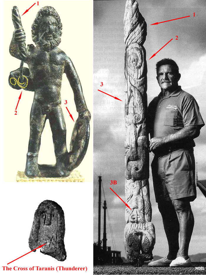
In the picture to the upper left is shown a statuette, found in France, which depicts the ancient god Taranis and his identifying elements. These are:
In the picture to the lower left is shown a "cross", known as the "Cross of Taranis" (Croix de Taranis). In pre-Christian France (Gaul) the spoked "thunder wheel" of Taranis was often represented as a "cross".
In the picture to the right is shown Curator of the Dargaville Maritime Museum, the late Noel Hilliam, holding an ancient totem (Nui pole), which was retrieved from wetlands in the north of New Zealand. The totem has, carved into it, all of the elements associated with Taranis, the Thunderer. These are:
Some accounts tell us that these ancient sun and volcano venerating people were held in high esteem for as long as 10-generations, until attacked and vanquished by the Polynesian Maori warriors seeking to possess fishing resources, gardens, villages and treasures (especially greenstone). For the Waihi district, as stated, Mayor Island (Tuhua), offshore, was a very rich resource of obsidian, which was a valuable trade commodity for whoever could possess the Island and control the resource.
Although the Waihi Beach stretch of shoreline was vulnerable to surging waves in severe gales lashing the coast from the open sea, nearby Bowentown Heads provided an entryway into a sheltered harbour. The twice a day tidal flows and currents through Bowentown Heads provided an abundant fishing ground and there was plenty of good arable terrain adjacent for gardens. It was once a very favorable place to live in peace and prosperity, for many generations of occupants, undoubtedly spanning thousands of years.
Martin Doutré, July 2nd 2019. ©