SO, WHO WAS POUKAWA MAN?
Back in the days when there were still vestiges of true archaeological research being undertaken in New Zealand, Lady Aileen Fox, renown British archaeologist, came to New Zealand in retirement to study so-called Maori hillforts. She was considered to be a leading world authority on Iron Age hillforts of Britain and Continental Europe. In 1972 she retired as Senior Lecturer in Archaeology at the University of Exeter, England and took up a position at Auckland University, New Zealand to teach Romano-British and Celtic archaeology.
Lady Fox was inspired to come to New Zealand by observations of anthropologist, Sir Raymond Firth who provided for the first volume of the English archaeological journal, Antiquity, a 1927 article on Maori hillforts. Other early writers she mentioned were Captain James Cook, Joseph Banks, Sydney Parkinson, Surville, Marion de Fresne, Crozet, le Roux, Dumont d’Urville, Louis de Saison, Samuel Marsden, William Yate, Henry Williams, etc., … to which we could add F.E. Manning and many more early writers who were mesmerised by the sheer magnitude of the hilltop excavations or number of these structures that dot the North Island landscape in their thousands. Manning wrote:
‘The old hillforts are many of them so large that an amount of labour must have been expended in trenching, terracing and fencing them, and all without iron tools, which increased the difficulty a hundred fold, which must have required a vastly greater population to accomplish than can now be found in the surrounding districts. These forts were also of such an extent that, taking into consideration the system of attack and defence used necessarily in those times, they would have been utterly untenable unless held by at least ten times the number of men the whole surrounding district, for two or three days’ journey, can produce; …’
Now, from the top of one of these pointed, trenched and terraced hills I have counted twenty others, all of equally large dimensions, and all within a distance, in every direction, of fifteen to twenty miles; and native tradition affirms that each of these hills was the stronghold of a separate hapu or clan, bearing its distinctive name. There is also the most unmistakable evidence of vast tracts of country, which have lain wild time out of mind, were once fully cultivated. …’
Many collections of these provision stores [pits for sweet potato storage] have outlived Maori tradition, and the natives can only conjecture who they belong to. Out of the centre of one of them which I have seen there is now growing a kauri tree one hundred and twenty feet high, and out of another a large totara.’ (See: Old New Zealand, by F.E. Manning, pp. 200 – 202 …based upon observations made in the 1830s).
Typical of the impression these massive hillforts had on new arrivees to New Zealand is a statement by Surveyor General, Felton Mathew of the 1840 NZ colonial government of William Hobson, who wrote:
“There are several very singular hills rising boldly from the surrounding land [Auckland], in shape and form closely resembling the Roman encampments on the Tumuli that abound in many parts of England & having like them three or four distinct fops or ditches encircling them towards the summit - This singular too that these have been formed for defence by the natives - the top of every hill is marked in this way with distinct lines of circumvallation. An antiquary might from this circumstance deduce a connection between the New Zealanders and the ancient Romans!!' (see Felton Mathew's unpublished letters to his wife, Special Collections, Auckland Public Library.
Another early explorer noted:
'Arriving at the foot of the mountain [Mt. Eden] we
assayed its ascent in the course of which my friend evinced a deep interest in
traces of Maori fortifications of a past age, which were everywhere in
evidence, the escarpments, trenches and what had once been covered ways and
store pits though fallen in or overgrown, were yet in a wonderful state of
recognition.
Several of the stone walls of these fortifications could still be traced with
considerable accuracy, although the oldest living Maori could not tell when, or
by whom, they were erected.
The Maori race show a wonderful aptitude for field engineering in warfare, and
these traces of ancient fortifications, in particular, have often called forth
the highest commendation from those most capable of judging such matters.
It must have taken a much larger population than was then to be found to man
these fortifications effectively, so extensive were they, the whole mountain
appearing to be girt by them, line after line, from bottom to top (see Sketches
of Early Colonisation in New Zealand -and its Phases of Contact With the Maori
Race, (circa late 1840's), by "Te Manuwiri", pg. 123, Whitcomb &
Tombs).
In the foreword of Lady Aileen Fox’s book, Prehistoric Maori Fortifications in the North Island of New Zealand, Dr. R.C. Green writes:
‘Native New Zealanders, known collectively today as Maori, had eastern Polynesians as ancestors. By the last half of the eighteenth-century AD they had developed in the course of a 1000 year* residence in New Zealand a variety of settlements, one of which, the fortified pa, attracted the attention and admiration of early European visitors and inhabitants. This is not surprising. Many of these newcomers were of British origin. Often, they had Celts as one or more of their ancestors, and in the last half of the first millennium B.C. Celts too constructed hillforts very similar to some Maori pa and participated in a society which had a number of features in common with the Maori. Both indigenous groups, moreover, used their fortifications in facing up to invasion by newcomers backed by a technologically more advanced civilisation, Romans on the one hand, the British military on the other. Thus, despite an absence of any historical connection with the Celts, Maori fortifications have long been a fruitful source for commentary, comparison and speculation.’
The comparisons extend well beyond the same or similar styles of fort construction. See: http://www.celticnz.co.nz/CelticMaoriDeathMyths/CelticMaoriDeathMyths.html
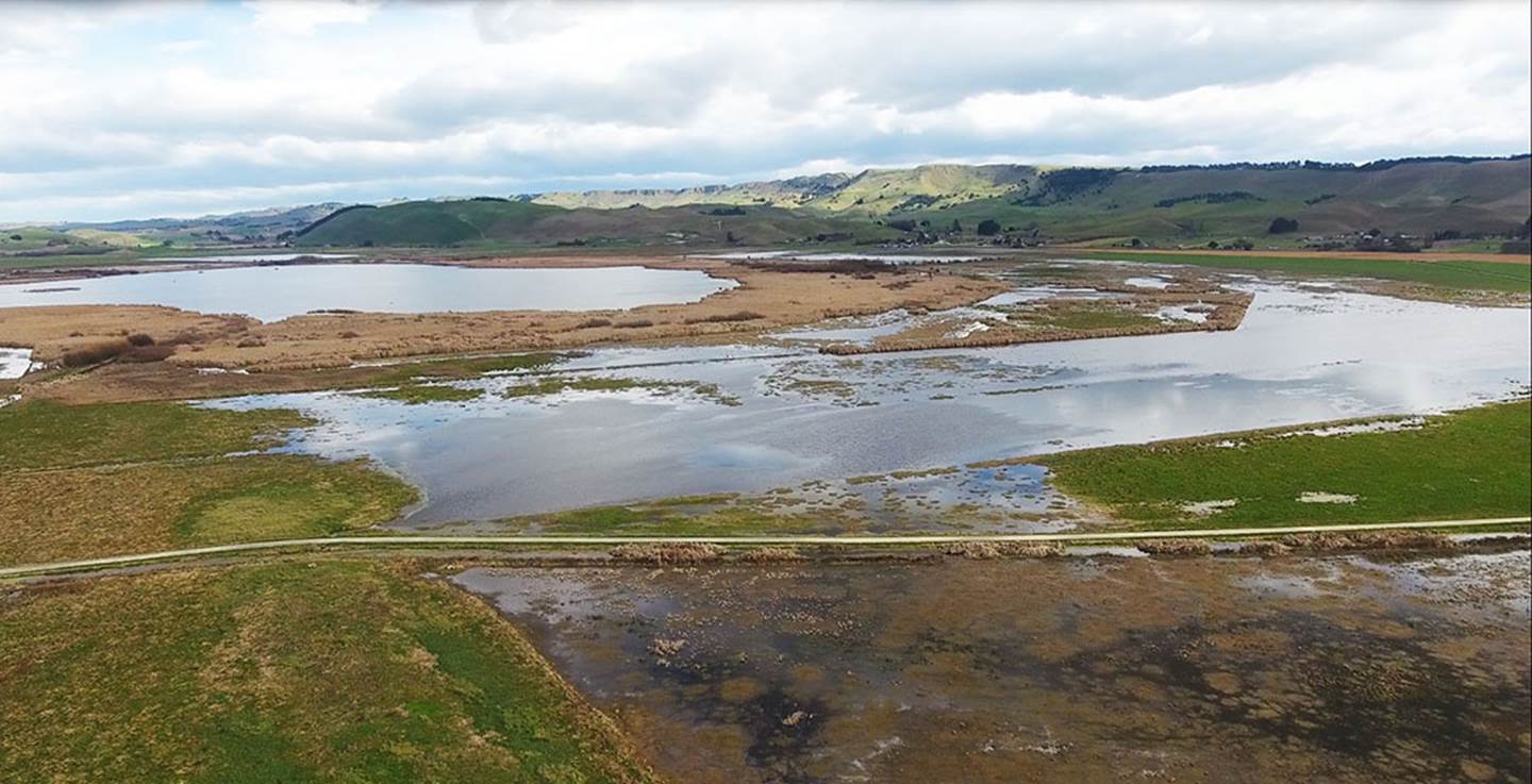
In the North Island of New Zealand there are an estimated 5000 of these fort structures that sit to the north of Lake Taupo alone, whereas in Britain there are less than half that number in the whole country. Many of the so-called for structures had no defensive capability and were simply the sites of small or large villages where extensive earthworks have been excavated solely for domestic convenience.
An area of interest for Lady Aileen Fox was the Hawkes Bay district where she and her teams undertook archaeological digs at Tirimoana pa, Te Awanga, only 17-miles (27 kilometres) NE from Russel Price’s main dig site in the Poukawa Valley. Let’s touch upon one of the many such ancient structures that are found in the Poukawa Valley or up on the high ranges circumnavigating the valley:
In preliminary discussions with farmer, Bill Buddo, we asked if there were any pre-colonial (or more ancient) hill-top structures in the valley that could have functioned as solar observatories. From experience in studying ancient community sites across New Zealand that pre-dated the era of Maori occupation, invariably there will be solar observatories for taking time fixes on an equinox or solstice rise or set. Being as Russell Price was finding evidence of very ancient occupation within the valley, it seemed obligatory that there had to be a solar observatory somewhere nearby. As it turns out, there was one only half a kilometre NE of Russell Price's dig Site 1.
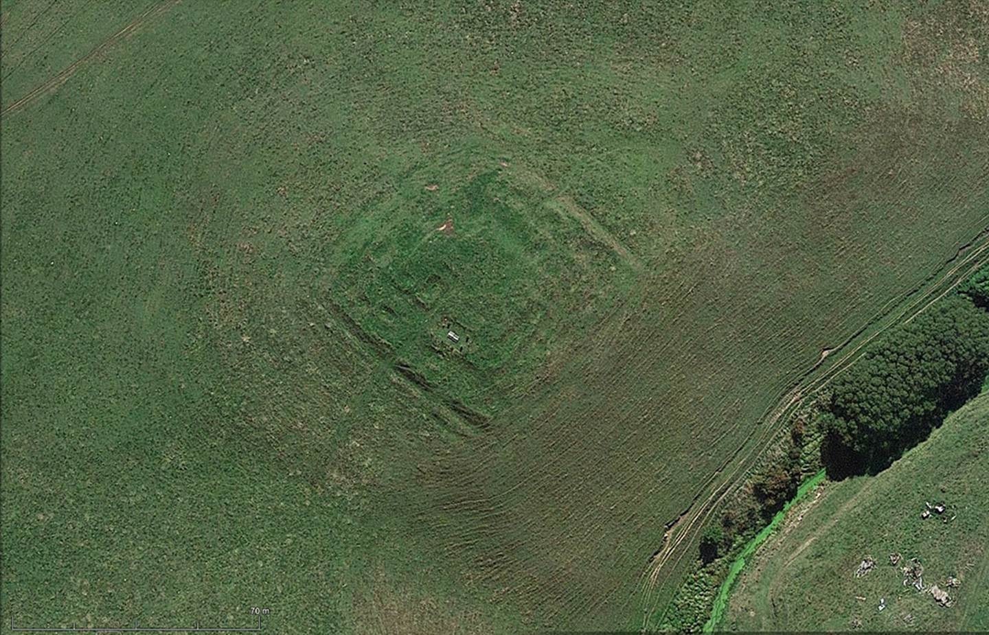
THE LOZENGE SHAPED, HILL-TOP SOLAR OBSERVATORY IN THE POUKAWA VALLEY.
Adjacent to the original outflow stream of Lake Poukawa and very near to where Russell Price commenced his first archaeological investigations at Sites 1 & 2, is a small hill with a lozenge shaped earthwork sitting on its crown. The position affords wonderful panoramic views throughout 360° of the skyline and is conveniently situated between long hill ranges to the east and west. Because the ranges stretch on a line that runs north-south, they offer the opportunity to get precise solar fixes onto the winter solstice rise and set, the equinox rise and set, as well as those of the summer solstice from the centre of the lozenge.
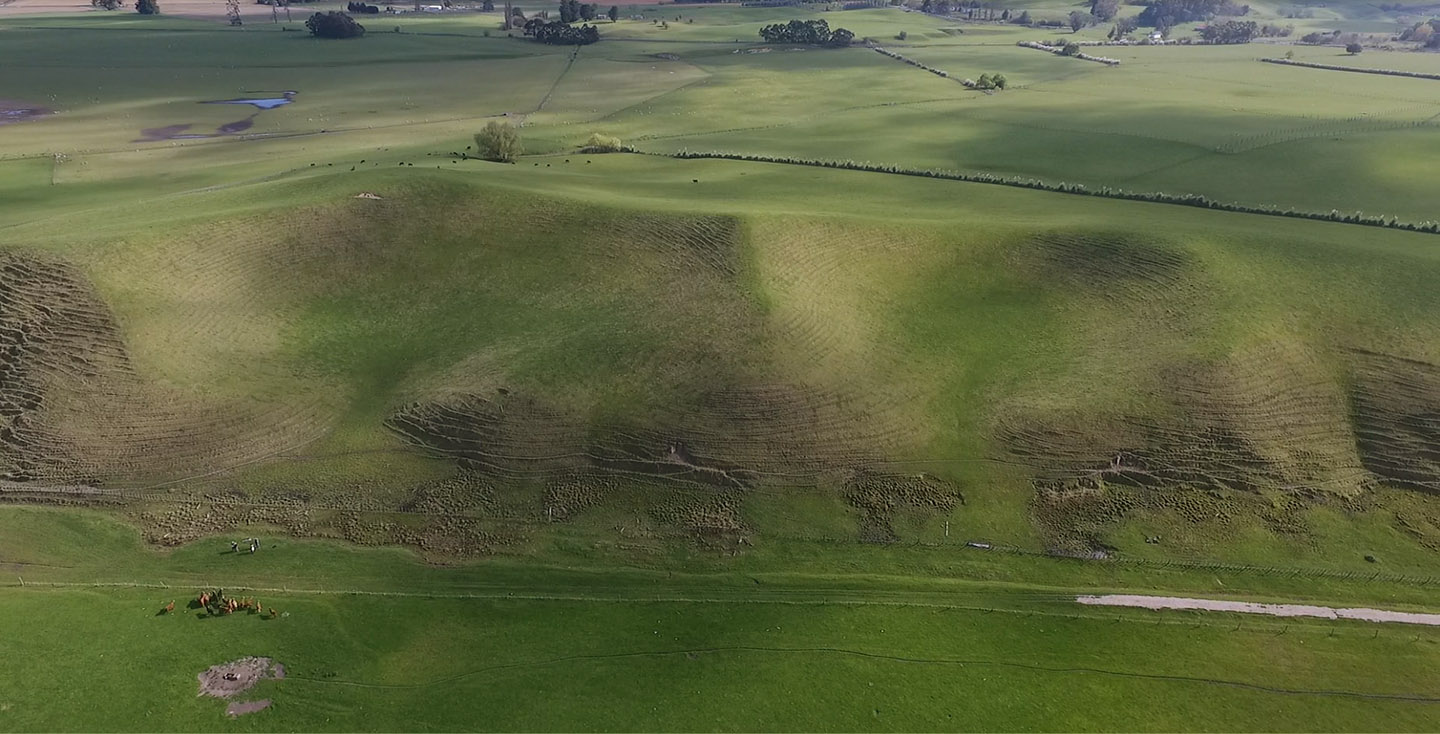
The now dilapidated lozenge shaped earthworks structure that rises in tiers or steps from the outer periphery to the centre platform. There appear to have been 4 ever decreasing in size but rising in height tier steps from the outside to the centre, a design concept that duplicates stylistically a famous English artifact from the Neolithic Age called the Bush Barrow Lozenge.

An AutoCAD scaled replica of the Bush Barrow Lozenge which was found very near to Stonehenge in the tumulus mound grave and lying on the chest of a man of obvious importance. The lozenge was fabricated in thinly beaten gold sheet and grave goods associated with the deceased suggested he was a priest forerunner to the later Druids. One item in the grave was a plane-table, anciently used in conjunction with an alidade sighting rule for accurate surveying of the landscape.
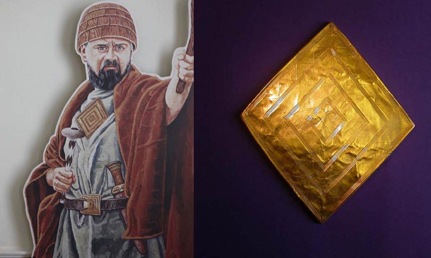
Professor John North comments concerning particular, surveying-related grave goods found at Bush Barrow tumulus mound: 'Fragments of wood that the excavators had thought were the remains of a shield were now described as the remains of an alidade (a sighting rule) and wooden drawing board or plane table.' (See: Stonehenge, Neolithic Man and the Cosmos, page 508).
So, by associating the ancient British lozenge design with surveying, are there any attributes of the Poukawa earthworks lozenge which show a surveying-related function?
As it turns out, one point of the Poukawa, multi-tiered, earth-mound lozenge orientates onto true north, with the other points orientating onto due east, due west and due south.
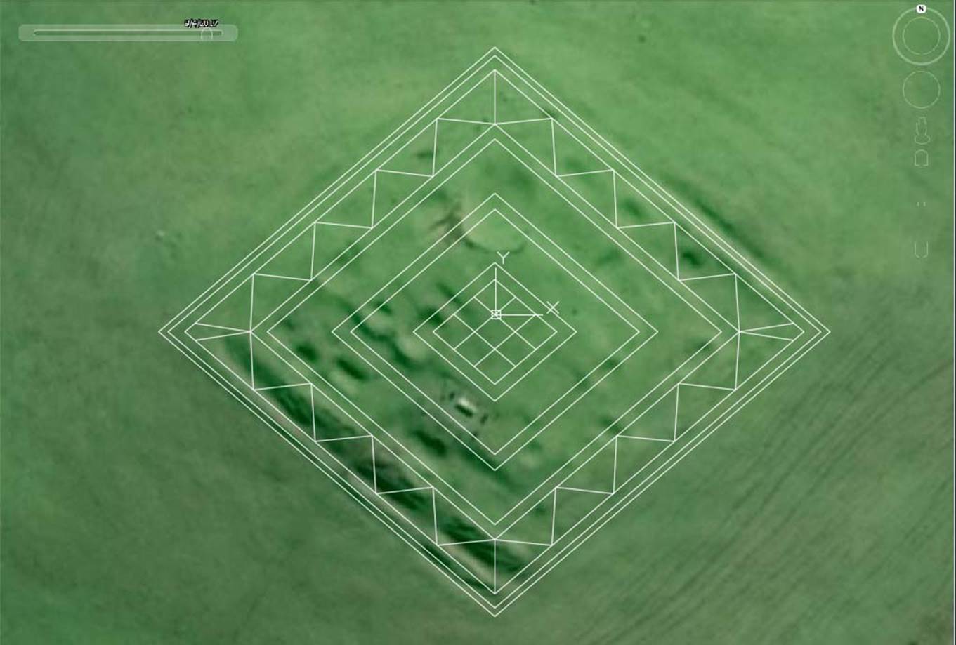
The original configuration of this site appears to have been quite similar in concept to a Bush Barrow Lozenge shape, with concentric, rising tiers as one moved further in towards the centre platform. It would seem that at latter eras pits were dug across the surface for roofed dwellings, where people could live below the wind line, however the evidence shows that the original builders had a surveying and solar observatory function in mind. The lozenge shape, superimposed over a Google Earth image, has its corners on the primary points of the compass.
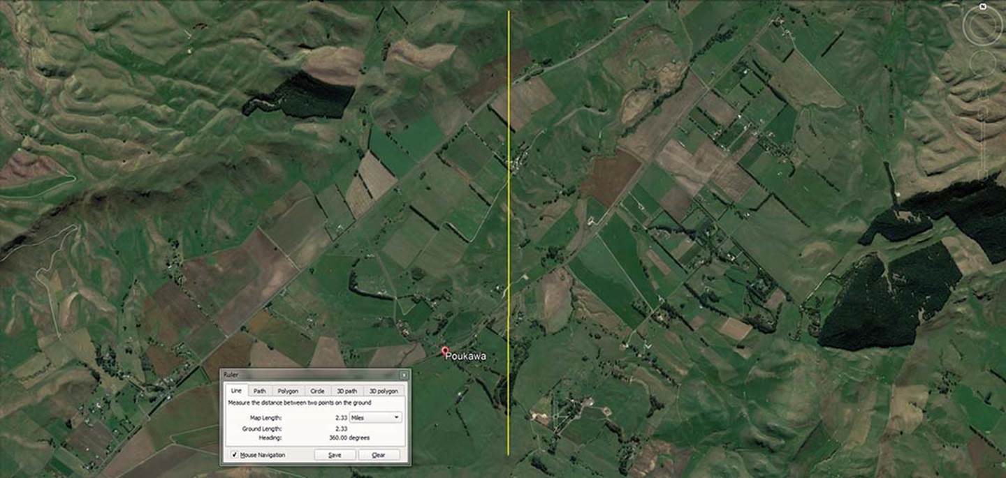
From the centre of the hill-top lozenge embankment a line is seen to run for 2.33 miles to a set of purpose-placed, obelisk boulders that mark due north. They sit in a row near the skyline of a high ridge and can be seen from the lozenge structure in reasonable weather. Ancient surveyors would have been able to fix their alidade sighting rule/plane table onto the true north marker, set a 360-degree disk to the zero point, then read precise angles to any other target around the horizon.
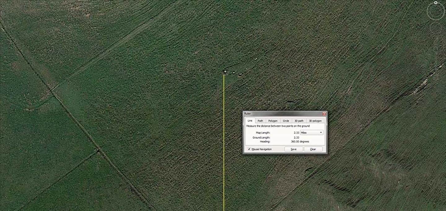
The line-up of purpose placed obelisks, the largest of which to the left marks due north. The others seem to have been placed to make the main marker more visually conspicuous and represent alternate shifts in the degree angle of .05 of a degree. There is no grouping of boulders like this in the immediate vicinity and these have obviously been placed in that precise position by human intervention.
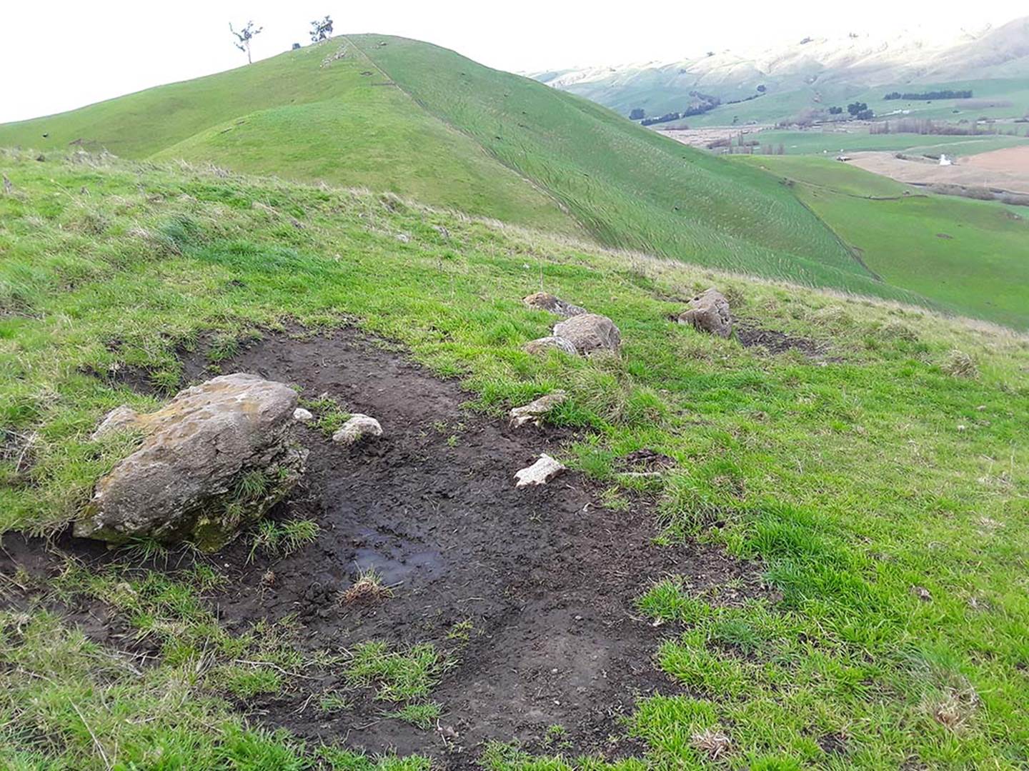
The line of anciently placed obelisks near the ridge top, with the biggest one in the foreground marking true north. It now lies recumbent and cattle are obviously clambering around it. What would have once been chock boulders to form a stabilising cradle under the standing stone now lie about nearby in the mud.
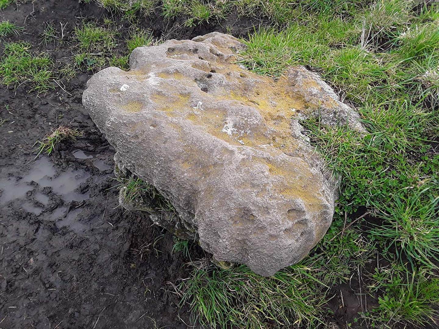
The ancient limestone obelisk, tumbled from its former position, but still indicating the position of due north from the centre of the lozenge structure in the valley.
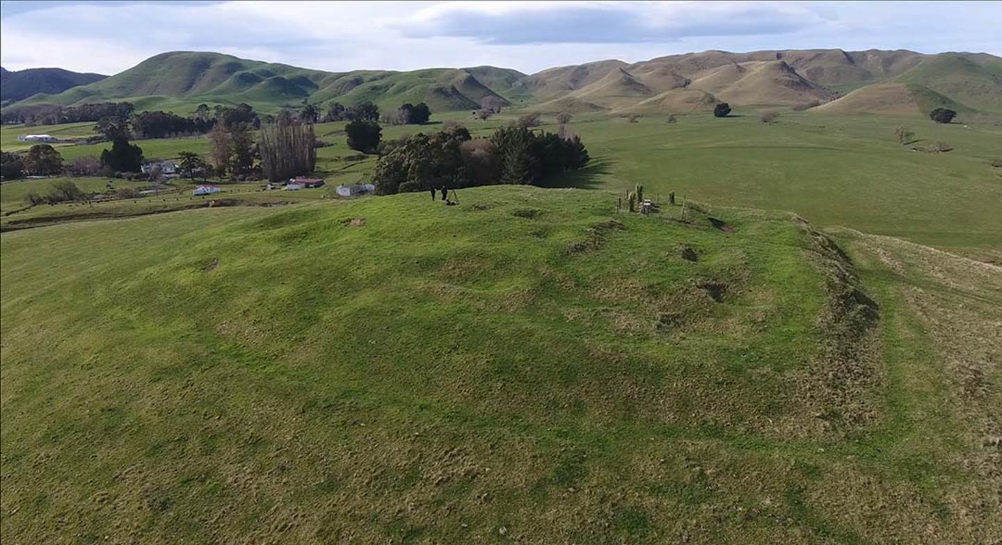
An aerial view of the now disheveled and pitted, stepped lozenge structure. The faint outlines of the rising concentric tiers can still be detected, but the ancient structure has been considerably dug over by the last Maori occupants who used it as a sentinel and defensive position during inter-tribal fighting.
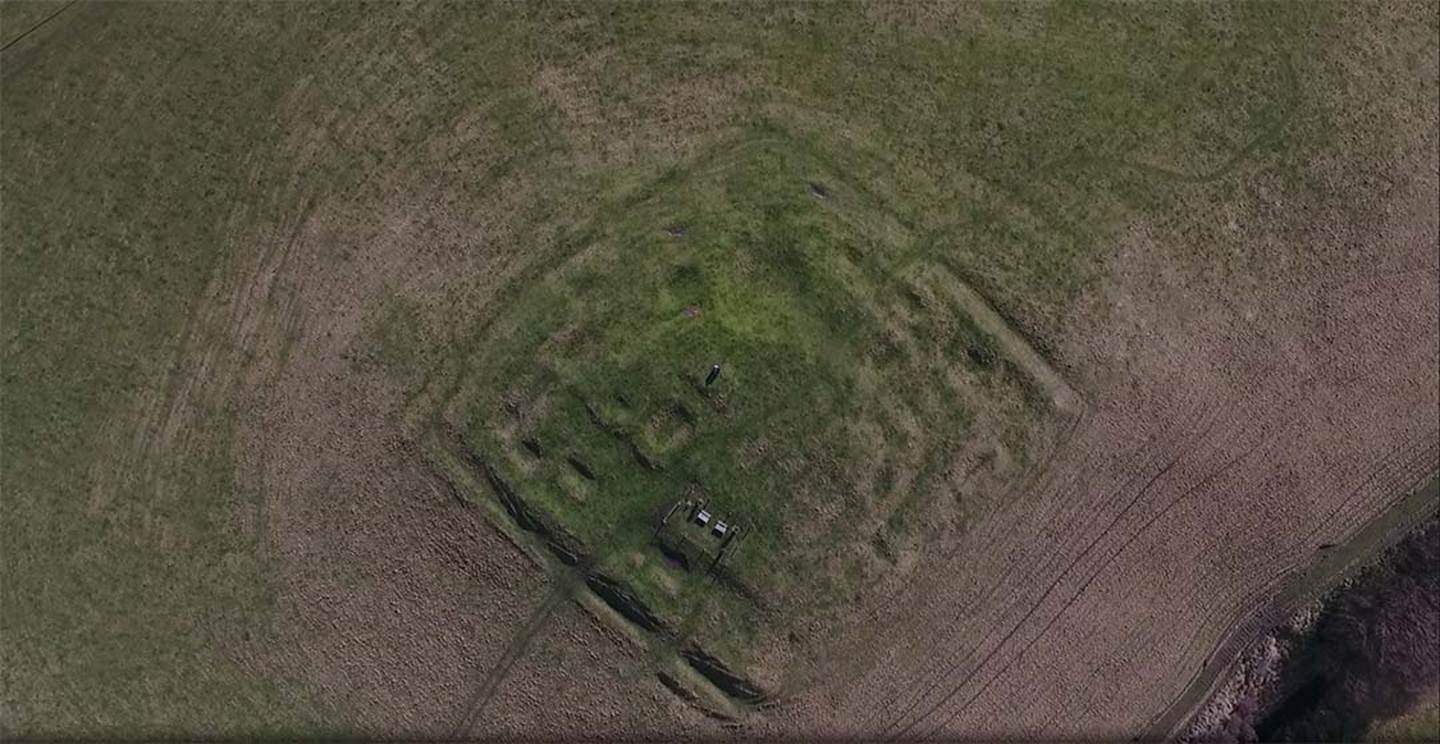
Another aerial shot. The corner at the top of the picture points to due north.
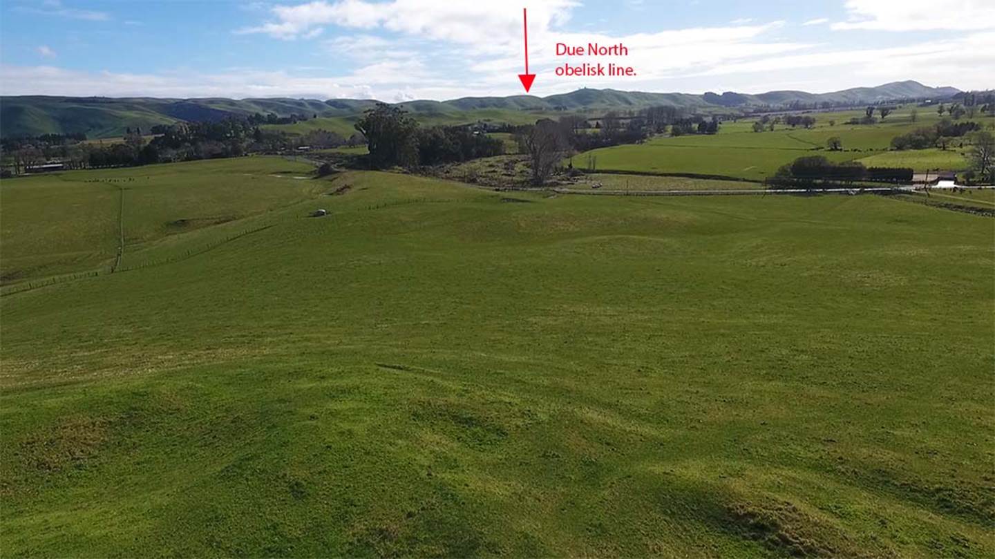
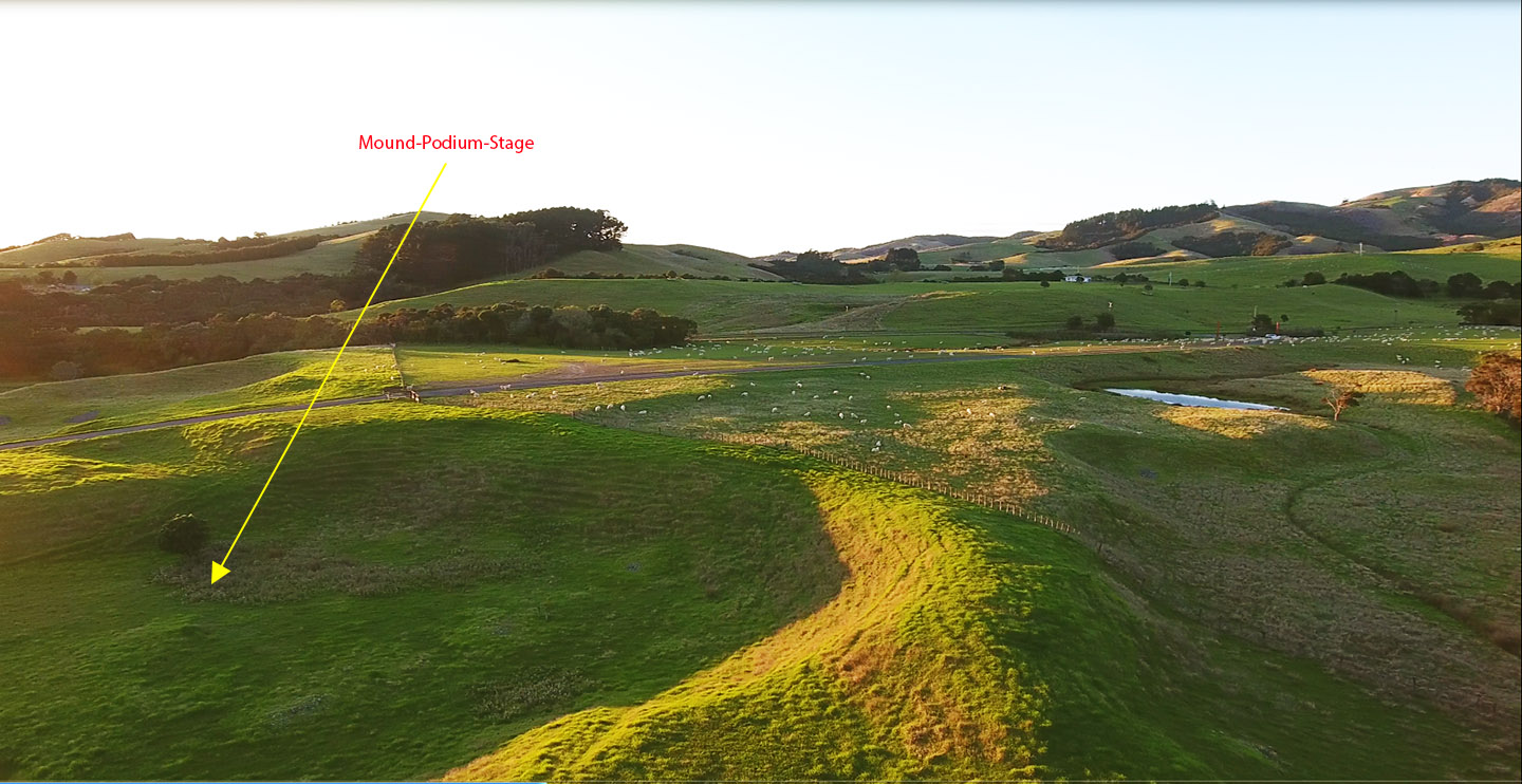
From the lozenge structure the obelisk line marking due north would be up on the range, as indicated by the arrow.
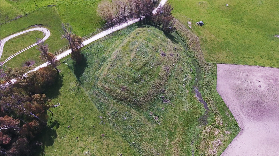
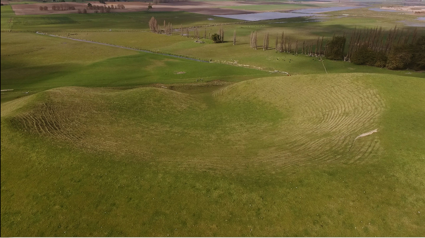
Yet another stepped, truncated pyramid in the Poukawa area and situated in the valley over the range westwards of where the due north markers are set out at the top of the ridge. The farmer has fenced it to ensure that no cattle can disturb the 4 rising tiers. In a first assessment it looks like it would work very well for a winter solstice sunrise fix, but the nearby ranges to the east and west should provide excellent fixes on the other major solar events throughout the year as well. for both rises and sets of the sun.
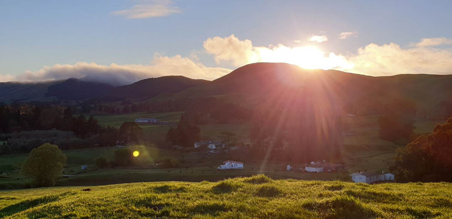
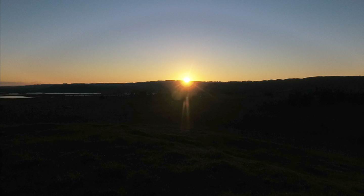
The vernal equinox sunrise 2019 from the centre of the lozenge earth mound. The long hill ranges to the east and west have distinctive troughs and humps, such that ancient astronomers, who knew their terrain intimately, could see when the sun arose perfectly on the outer-marker, geological feature that represented a “fix” for the equinox day. The long ranges provide the ability to get perfect fixes onto summer solstice, equinox and winter solstice rises and sets of the sun, such that calendar counts throughout the year would be accurate.
The equinox sunset on the western range. By knowing elevation above sea level where the sun emerged or alighted on the ranges, as well as the diagonal angle of the rising or setting sun at the equinox, calculations were possible for determining “true north”.
AMPHITHEATRES
Amongst the many descriptions that have been passed down to us via Maori oral traditions, we have the following:
'Besides gods, the natives believed in the existence of other beings, who lived in communities, built pas, and were occupied with similar pursuits to those of men. These were called Patu-paearehe. Their chief residences were on the tops of lofty hills, and they are said to have been the spiritual occupants of the country prior to the arrival of the Maori, and to retire as they advance. The Wanganui natives state, that when they first came to reside on the banks of the river, almost all the chief heights were occupied by the Patu-pae-arehe, who gradually abandoned the river, and that even until a few generations ago, they had their favorite haunts there. These may be accounts of an aboriginal race mixed with fable; there are several things to warrant the idea that the Maori were not the first inhabitants of the land.
The Patu-paearehe were only seen early in the morning, and are represented as being white, and clothed in white garments of the same form and texture as their own; in fact, they may be called the children of the mist. They are supposed to be of large size, and may be regarded as giants, although in some respects they resemble our fairies. They are seldom seen alone, but generally in large numbers; they are loud speakers, and delight in playing on the putorino (flute); they are said to nurse their children in their arms, the same as Europeans, and not to carry them in the Maori style, on the back or hip. Their faces are papatea, not tattooed, and in this respect also, they resemble Europeans. They hold long councils, and sing very loud; they often go and sit in cultivations, which are completely filled with them, so as to be frequently mistaken for a war party; but they never injure the ground;
The belief in the Patu-paearehe is very general; many have affirmed to me, that they have repeatedly met with them. Albinos are said to be their offspring, and they are accused of frequently surprising women in the bush.'
See: Te Ika a Maui, by Reverend Richard Taylor, pp 46-47. http://nzetc.victoria.ac.nz/tm/scholarly/tei-TayTeik-t1-body-d1-d3.html#n67
Another kind of structure that one would expect to find where ancient communities were large in number is the bowl-type amphitheatre. It seems to have been a common practice amongst the ancient inhabitants of New Zealand to modify natural bowl-like land features into semi-terraced or smooth-ground amphitheatres where the acoustics were much improved and people could gather together for story telling oratory, music and dance displays, general entertainment, councils, etc.
These large, symmetrical, amphitheatre-like features are found in many locations across New Zealand where sizable ancient communities are known to have resided and, sometimes, there will be side-by-side amphitheatres where the communities were particularly large. This is the case in the Poukawa Valley.
These symmetrical, hillside bowl depressions in the Poukawa landscape would once have sat at the lake edge, with the lapping shoreline water sufficiently low to provide solid-ground, trackway access to the natural or semi-natural amphitheatres. These two probable amphitheatres and a much smaller third one to the west would have been ideal for community social gatherings, oratory and entertainment. Some of these amphitheatres around New Zealand had centrally built, elongated mounds, strategically-placed for line-dancing displays or oratory, where the speakers or musicians could project very effectively and audibly to the encircling audience.
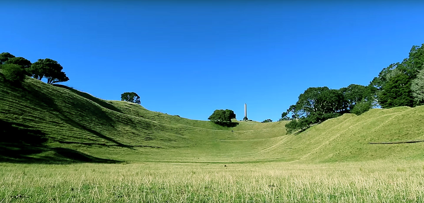
A view of the largest Poukawa amphitheatre, looking south to the lake centre from the rear of the bowl rim. Note the small, pinched together entrance, effectively sheltering the gathered-in occupants from the prevailing wind. Speakers or performers could stand near the entryway or more centrally to face and interact with their audience.
Another large amphitheatre bowl at Tapapakanga Park, Orere Point, towards Thames NZ where there was once a large community of Patu-paiarehe (umbrella tern used by Maori to relate to the people they found in New Zealand when they arrived in 1300 AD). Maori oral traditions speak of these people being vanquished and forced to flee to the nearby Coromandel Ranges. There are two such amphitheatres at Tapapakanga Park. This one has a raised central mound that would have worked well for orators or musician/singers to stand upon when performing their arts before the encircling audience.
A large bowl enclosure at highly carved and terraced, One Tree Hill, Auckland, NZ. Again it would have been very effective for performances before a large seated audience.
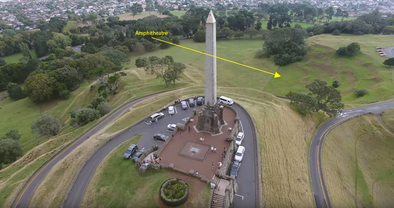
Another view of the One Tree Hill amphitheatre from behind the giant plinth/obelisk. Note the carved terracing that could have accommodated a large audience.
EPILOGUE
McFadgen’s “Antiquidity (sic) of Man at Lake Poukawa, New Zealand, October 1978 begins with an “Abstract”, containing 3 statements of interest:
Archaeological excavation of a Maori occupation site at Lake Poukawa shows the site was probably occupied between 150 and 300 years ago and has been badly disturbed by European farming. There is no evidence for human occupation before the Taupo Pumice eruption.
Response:
According to our so-called leading experts, all known species of Moa birds were wiped out by the year 1400 AD (circa 600-years ago). Here are some quotes:
‘…Moa were plentiful in New Zealand upon Polynesian arrival but were extinct within a century as a result of hunting and habitat loss (Anderson 1989 a,b; Holdaway et al. 2014, Perry et al. 2014). Also we have this statement: ‘Several decades later there is still no convincing direct evidence of humans on the New Zealand landscape any earlier than 1300 AD…’ (See: https://blogs.otago.ac.nz/globalmigration/files/2018/09/Walter-et-al-2017.pdf ).
However, at least 21,700 bones of now long-extinct birds, including many moa of most types, were found at Poukawa by Russell Price and his team. About 85% of these were found to have been cooked, broken into smaller sections, cut with obsidian knives to remove flesh, gouged or sawn and thrown together into middens with hyridella shells, etc. Also, crop stones of Moa and other birds were found in piles, well away from any bones of birds that would have ingested them. In addition, most of these cooked and broken bones, bearing man made or inflicted marks, were located below any Maori occupation-era of strata. Most were under the ash band of the Taupo volcanic explosion of 186 AD.
Because of the above factors, McFadgen’s statement that human occupation was only 150 to 300 years ago is ridiculous. If one is to postulate such a hypothesis, then it has to have some element of workability, but McFadgen’s estimate of human occupation is too far removed from the very last of any Moa hunting activity at Poukawa by a span of 300 to 450-years.
Added to the above is the indisputable evidence of C14 results issued by the DSIR Radiocarbon Dating Lab Lower Hutt, under the direction of scientist, Dr Athol Rafter. Human bones, cooked Moa bones or those of other bird species, hyridella shells, carved artefact's, etc., returned very ancient C14 dates, the oldest of which for Poukawa was 7170-years + or - 60-years before 1950.
His statement that European farming has badly disturbed ground at Poukawa is also untrue. The formerly underwater, but now drained farm flats in the valley, lie on peat soil, where surface weeds like fescue need to be removed by tracked crawlers that have a large footprint, as opposed to wheel tractors that don’t. Because the peat has lost its water, cracked and shrunk, it can easily be crushed downwards by heavy weight, thus compressing it towards the water table and increasing the risk of flooded fields. Bladeless excavators, pulling lightweight surface disks, distribute the weight of the machine to such an extent that no damage occurs.
At the same time the valley floor has many higher ground areas that have never been underwater, as evidenced by thousands of years of undisturbed, stratified soil layers. The region is conducive to, or best suited for, grazing cattle and sheep and only minor surface maintenance is required by machinery.
McFadgen’s statement that there is no evidence for human occupation before the Taupo Pumice eruption is completely untrue, as cooked Moa bones and those of other species, clearly eaten, scratched and broken by humans, were found deep below the Taupo ash band and even below the Waimihia ash band. These were C14 tested by the DSIR Radiocarbon Dating Laboratory and verified by Dr. Athol Rafter and his lab technicians to have been up to 7000-years old.
McFadgen’s Introduction.
In his Introduction McFadgen makes the statements: "reported in New Zealand Archaeology Association newsletter, Price 1963/1965" … "that Maori occupation remains” .... "Had been found below the Taupo pumice", conflicts to a "generally accepted date of 1000 BP."
McFadgen seems to infer that if something conflicts to a generally accepted date with, what he sees as, the peer consensus, then it must be wrong. As it turns out, McFadgen(quoting Wellman 1962*) was out-of-step with the large number of leading New Zealand scientists who had tested Price’s findings and found them to be scientifically proven by the most up-to-date methods available. At the time, the 1000 BP date of human occupation was under severe review, based upon new, compelling evidence coming to light.
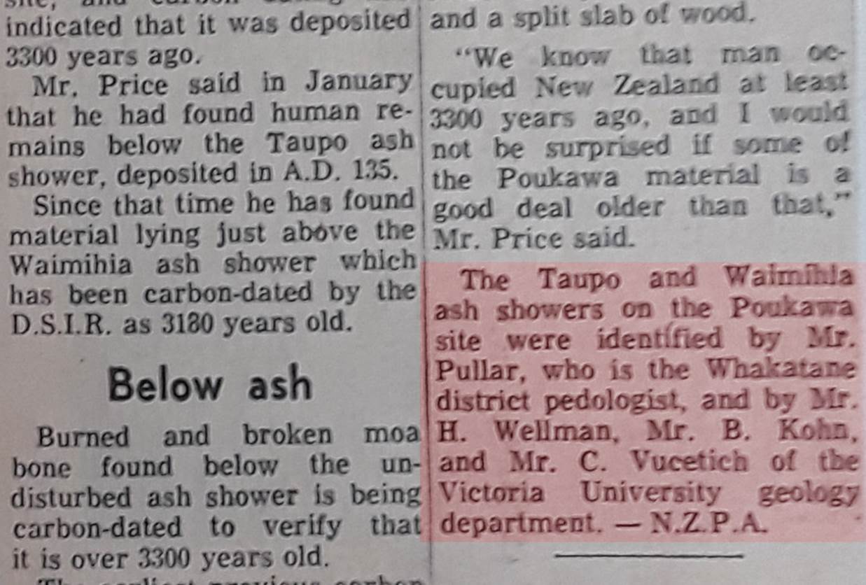
* Footnote: In this Introduction, McFadgen quotes and early article by Wellman (1962) to support his contention of no occupation found below the Taupo ash. However, he fails to mention that in 1969 Wellman, along with the other credentialed, senior geologists of the Victoria University Geology Department, namely Kohn and Vucetich, concurred, in agreement with leading pedologist Allan Pullar, that there was indisputable evidence of human occupation situated below the Taupo and Waimahia ash bands. They tested this themselves on-site at Poukawa.
Also conflicting with the generally accepted date of 1000 BP was an artifact uncovered by archaeologist, Lady Aileen Fox in 1973 at Tirimoana PA, Hawkes Bay, a mere 19-miles from Russell Price’s 4 main dig sites. Carbon 14 age testing by the DSIR Radiocarbon Dating Lab of a well-preserved door portal found by Fox and her team returned a date of 1600 BC.
McFadgen says that in August 1973, with the permission of Mr Price, site N141/12 was studied by Victoria University Wellington Geology Department.
This is, at best, an exaggeration or, at worst, an outright lie!
Farmer David Buddo has no recollection of Bruce McFadgen or any group representing themselves as Victoria University Wellington Geology Department coming onto his farm, nor does Bill Buddo, who now owns the farm next door and often worked on digs with Price.
Certainly, these interlopers did not introduce themselves to David Buddo nor ask permission to conduct a formal archaeological dig, which should have been done as a basic courtesy and policy requirement under the university rules. David Buddo considers that this group of nameless, faceless people were “sneaky” in the way they came and went unannounced.
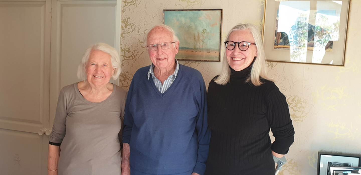
The David Buddo farming family, from left: Ros, David and Cathy, who worked in with Russell Price and had tremendous respect for the man and his genuine accomplishments. Like so many others they were devastated when Price’s 25-years of hard work were so unfairly nullified and marginalised in the eyes of the public. They had seen the accumulating evidence for themselves, over several years, and knew Price was correct in his conclusions. None of them remember Bruce McFadgen or his associates being on the farm property and were never consulted about Victoria University undertaking a formal dig on the farm. From the family’s point of view, McFadgen’s comings and goings seem sneaky and, in retrospect, reek of something unsavoury and suspicious going down. McFadgen and Victoria University owe them an explanation and apology.
But McFadgen says elsewhere in his acknowledgments that those who came to the site (who gave in the field assistance) were” Members of the Victoria University Geological Society and the Wellington Archaeological Society, with the Victoria University Internal Research Committee funding the work.
So who were these “Societies” and what’s an “Internal Research Committee” ?
They are certainly not The Victoria University Geology Department!
What are the names of all the people involved?
How long were they on site?
Where did they all stay in the region and for how long?
By the known evidence on-site or recorded as a drawing within McFadgen’s site map, we know their dig was very small and superficial, so how did they arrive at such far-reaching conclusions?
How comprehensive do they consider their dig to have been, when their own photos show cracked peat near the surface of what was underwater lake bottom only 42-years previously ?
Where is the proof that they scientifically scrutinised the actual permanent-dry-ground excavations of Russell Price which had already been scrutinised and tested by leading, aligned scientists and declared to be intact, unbroken and sealing everything beneath them?
Who are we dealing with here and what were their qualifications to draw such influential conclusions?
Certainly, McFadgen himself was only qualified as a surveyor at that time and held a minor degree in a category of social anthropology. He was not a qualified archaeologist, geologist, nor did he have any credentialed qualification in tephrostratigraphy. Under such circumstances who authorised him to spearhead such an investigation?
The Victoria University Geological Society is a social entity for staff and students interested in geology. Their mission statement says: Past events have included guest speakers, quiz nights, sports events, movie nights, field trips (including a trip this year to White Island), pub-crawls and student symposiums at GNS. So it’s looking more-&-more like we have a casual bunch of student and staff day-trippers out on a field trip to see Russell Price’s dig at Site N141/12.
The Wellington Archaeological Society is likewise a social entity, ‘with a membership spanning professionals, amateurs, students, organisations, businesses and institutions involved or interested in New Zealand archaeology and heritage’. Again, more day-trippers off on an adventure to check out Price’s dig and have a fun & informative tiki-tour of his site.
The Victoria University Internal Research Committee provided the funding for this caper. This ‘Joint Research Committee deliberates on matters relevant to the research portfolios of the Faculty of Education, Faculty of Humanities and Social Sciences and the New Zealand School of Music.’ In 1973 when McFadgen et al went to Poukawa, the Victoria University Internal Research Committee was allocated government funds for particular research projects and the Committee obviously saw this outing as important, sufficient to provide the funding. So, how much was spent to cover the costs of how many participants?
The other strange aspect of this discourteous, sneak in – sneak out pseudo-clandestine operation is that McFadgen’s devastating report didn’t appear for 5-years, until 1978. Why is that?
He’d been studying for a degree in geology at Victoria University during that time, so had he thought that publishing too early could mean that his scientifically-bereft report wouldn’t get any traction due to his lack of any suitable credentials and content?
It is the general opinion of Bill and David Buddo, as well as a large group of other Price supporters of the time, that McFadgen’s sole purpose was to do a hatchet job on Price’s credibility. Already, the actual Victoria University Geology Department had backed Price’s work and conclusions, so who were these society and internal research committee people, masquerading as qualified geologists and where is their formal, comprehensive geological report covering the totality of Site N141/12?
So, it seems that more minor staff, functionaries or students within Victoria University were undermining the work of the senior staff of the Geology Department, namely Drs. Wellman, Kohn & Vucetich, who were fully in agreement with Price’s findings.
(Excerpt taken from the Dominion Newspaper, 6th of May 1969).
McFadgen’s title, The Poukawa site.
McFadgen states in this section: "Lying very close to a recently active fault".
There was an earthquake in early 1931 which devastated the nearby city of Napier. The epicentre of the shockwave was 50-kilometres to the NNW of Poukawa Lake. In the Poukawa Valley there was no perceivable surface damage of serious consequence. Brick chimneys of some houses were shaken down and the newly made canal suffered some slips on its embankments. In the swamp section of the canal the soft lake bottom rose a few feet. These problems were rectified in 1931 or later.
What McFadgen seemingly tries to portray here is that the widely separated sites, 1-2-3-4, where Price dug were all seriously affected, causing the ground to crack and move everywhere within.
By McFadgen’s inference, this seismic shock was so intense that everything went topsy-turvy, cascading bones or artefact's in higher strata down into the depths, where intact bones were subsequently crushed, tumbled and broken by the pulsating ground, thus positioning them somewhere other than at their original strata level.
Such an Armageddon-type catastrophe clearly did not happen and the observations of the foremost New Zealand tephrostratigraphy scientists, Alan Pullar and Collin Vucetich confirm this. They found unbroken, cement-like ash bands with no fissures running through them. Bones and artefact's located by Price were clearly in original situ, where they had lain for centuries or millennial undisturbed.
McFadgen states elsewhere: "The mound is thought to have been raised by an earthquake before human settlement"
We have to conclude that the “mound” to which McFadgen is referring is the expansive, humped-up terrain where Price conducted his digs at site N141/12. It’s significant that McFadgen’s sparse dig of 1973 was not actually on or near to this mound’s summit, but well off to the NE side, down in the former lakebed flat. It’s unknown why McFadgen felt he needed to make this statement about the mound hump being the result of an ancient earthquake, unless perhaps it was to bolster his argument that earthquakes occur and sometimes raise land in the process?
Regardless, the air-laid ash bands of the mound above the lake water line were sealed over and unbroken throughout the entire period of human occupation, spanning thousands of years:
Price’s letter description states: Results of this effort are as follows: 1) we now have an almost perfect line up of stake and post holes all sealed over by the Taupo Ash for a distance of 50ft indicating that these early people were in occupation for a considerable period of time, our chances of recovering Human remains of this period have now increased by 1000%. (See: T.R. Price to T.A. Rafter, 16th October 1969).
In another such occurrence, supposed post holes turned out to be what Rafter described as “occupation material”. Dr. Athol Rafter writes:
‘The latest results seem to indicate that what we are seeing are not post-holes, but occupation material. The results which will be reported to you separately are for the top of the "post" 2530+/-40, and for the bottom 3200+/-45.’ These dates, of course, refer to years before 1950. (See T.A. Rafter to T.R. Price, 6th May 1970).
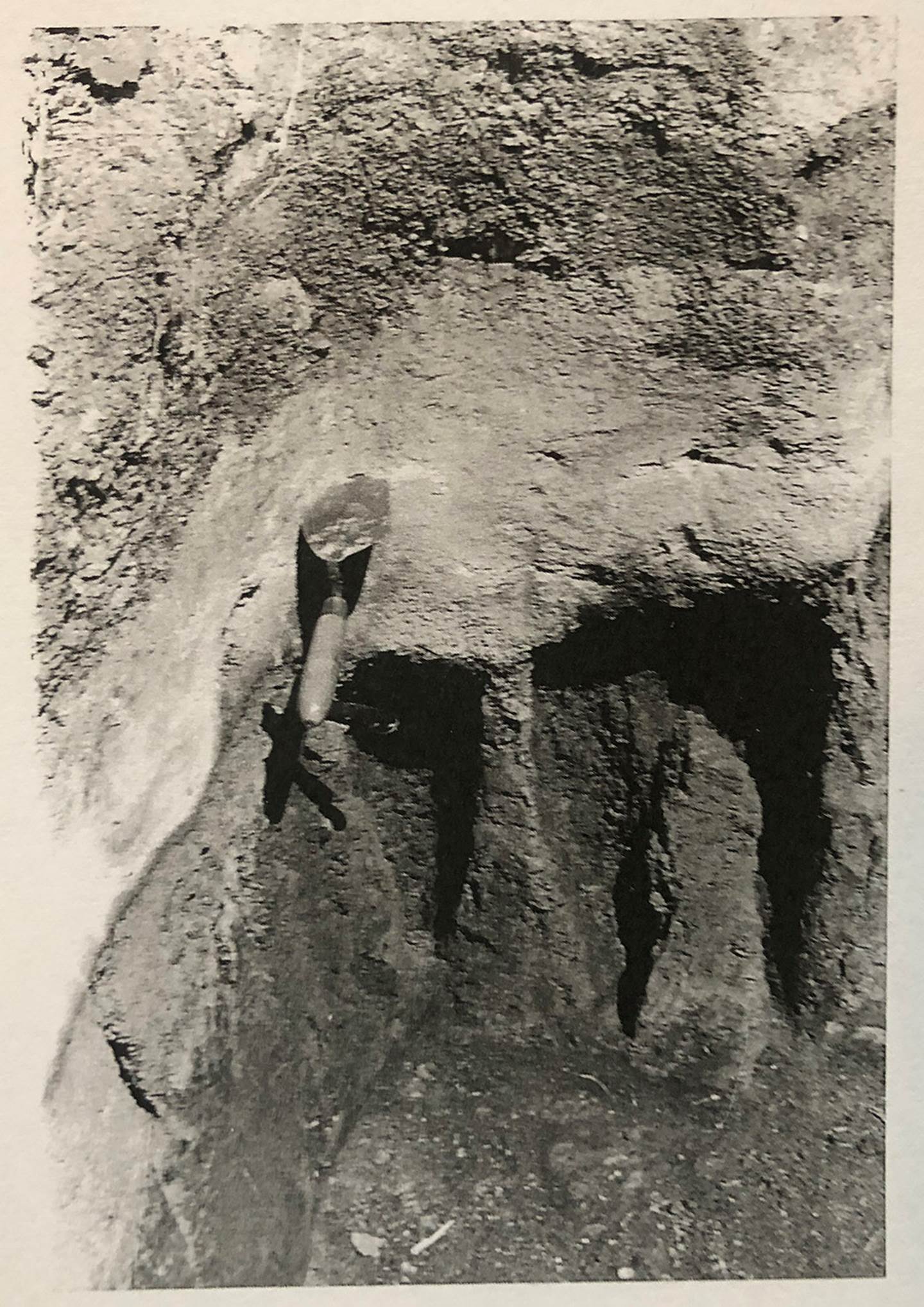
Here are Price's “post holes”, extending in a line for 50-feet (15 metres), but sitting below the undisturbed ash band from the Taupo explosion of 186 AD. The trowel has been pushed into the thick ash band layer (white coloured).
McFadgen states: "The supposed pre-Taupo remains including two alleged fireplaces are in peat on the north side of the mound”.
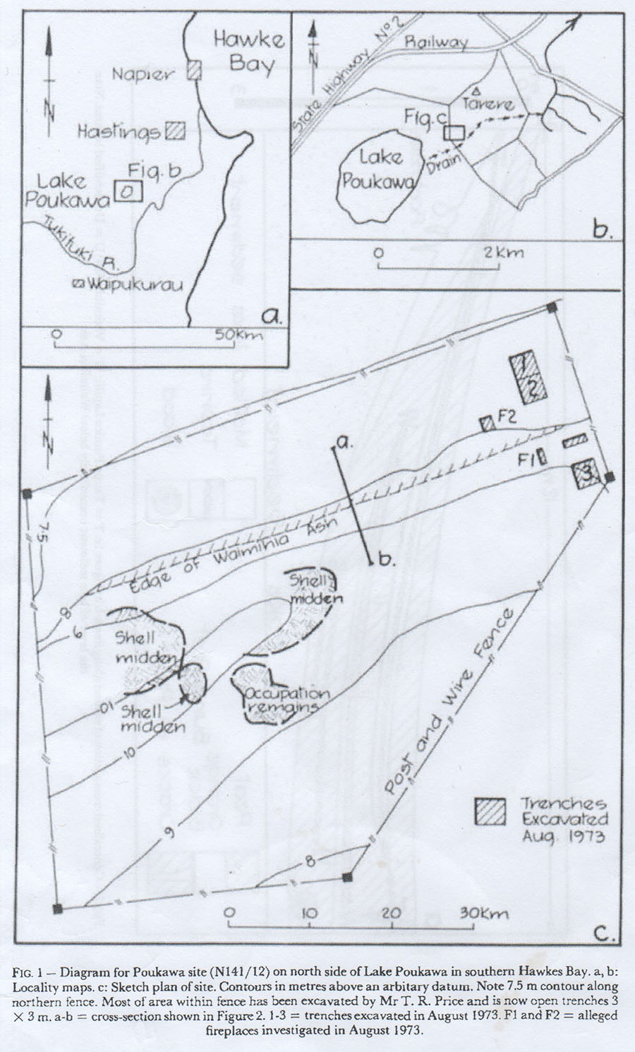
In McFadgen’s sketch plan 3 he marks 2 small spots as F1 & F2, then calls them “alleged fireplaces investigated in 1973”. Both tiny spots sit at what would have been the shore edge of the lapping lake water and were excavations he undertook or oversaw himself. Such surface or near surface positions, if ever actually used as “fireplaces” probably stem from the more recent era of Maori occupation. They are certainly not within a range of any of Price’s known dig spots, so what is McFadgen hoping to prove here? One could possibly surmise that a water’s edge fireplace for cooking would work well, as the underlying wet peat wouldn’t catch on fire, as so often happens in dry peat beds.
At least at the end of this section McFadgen admits that none of the spots where he dug were on ground where Price had dug.
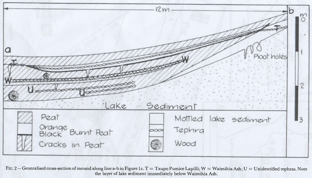
McFadgen states: "Figure 2", shows lake sediment rising into a mound.
Mc Fadgen’s Results of investigation.
He states: "A cross-section of northern side of the mound is shown in figure 2".
"Figure 2", indicates the length of the trench to make this cross-section drawing as 12m long and 3m deep. But McFadgen, based upon observations from this author’s on-site investigations or by McFadgen’s sketch plan (C) never dug any such trench himself. The line marked “a” to “b” on his Fig. 2 drawing seems to have been produced from a pollen core sampling line undertaken by soil scientists working in with Price.
Again, Fig. 2 appears to be a: “Generalised” cross section schematic by soil scientists, to which McFadgen seems to have added his own blocks indicating “peat, orange-black burnt peat, cracks in peat, mottled lake sediment, tephra and wood” (possibly from a cross section plan used earlier by Ichthyologist Peter Horn?).
The area marked as Lake Sediment lies below the actual peat lakebed sediment and, seemingly, should just be considered a subsoil of no particular designation. The sub terrain and strata of all of Price’s dig sites varied quite considerably, as evidenced by his detailed cross-sections. The same generalised schematic, devoid of McFadgen’s categorised index, was used by Ornithologist-Ichthyologist, Peter Horn who worked on this site with Price during 1973 to 1975.
It seems very strange that McFadgen chose to dig at a very low spot on the northern side of the humped-up, permanently dry terrain where, by McFadgen's own results, showed that the area provided useless data, At the same time Russell Price was getting very successful results and useful material up & over the hump to the south of where McFadgen chose to dig. McFadgen’s dig did not overlap onto Price’s dig site but was well beyond the northeast corner of it in the dried-out lakebed.
This is very suspicious and sounds like a case of simply trying to prove Price wrong, using a known worthless spot to somehow represent Price’s totally separate work and findings. They were never one and the same dig spots, but widely separate areas altogether.
Price would have shook his head in bewilderment, knowing McFadgen’s chosen spot would achieve nothing but a look down into cracked peat … but you’ve got to let the kiddies have a play … who knows, it might lead on to some of them becoming seasoned archaeologists one day!
McFadgen states: "The presence of an old lakeshore would suggest that the bird bones are from stranded carcasses."
This is clearly wrong:
From Price’s earliest excavations at sites 1 & 2 in the early to mid-1960s he found cooking pits or ovens atop the “Moa hunter campsite mounds”. He wrote how the charcoal blackened cooking pits were found to be clean of debris (bird bones), but that large quantities of the cooked, discarded bones were found in heaps down in, what anciently had been, the lake water directly in front of the cooking pits. Likewise, crop stones of the birds were found in sizable heaps, beside the cooking pits rather than in a solitary small batch that one could attribute to a single “stranded” bird. It’s very obvious, as well as practical, that the pits were frequently cleaned out and readied to receive the next batch of moa meat for the ongoing cook-ups.
Russell Price found that, up on dry land, but under the unbroken Taupo ash layer, there were stone tools and thousands of cooked bones, broken up during moa hunter feasts, and many of the bones bore cut, saw or gouge marks made by humans. Price insisted much later, after his scientifically-gained conclusions were assailed, that there were clear signs of human activity, unless ‘ancient moa spent their time breaking themselves up and cooking each other’.
McFadgen states: "The peat is extensively cracked figure 3".
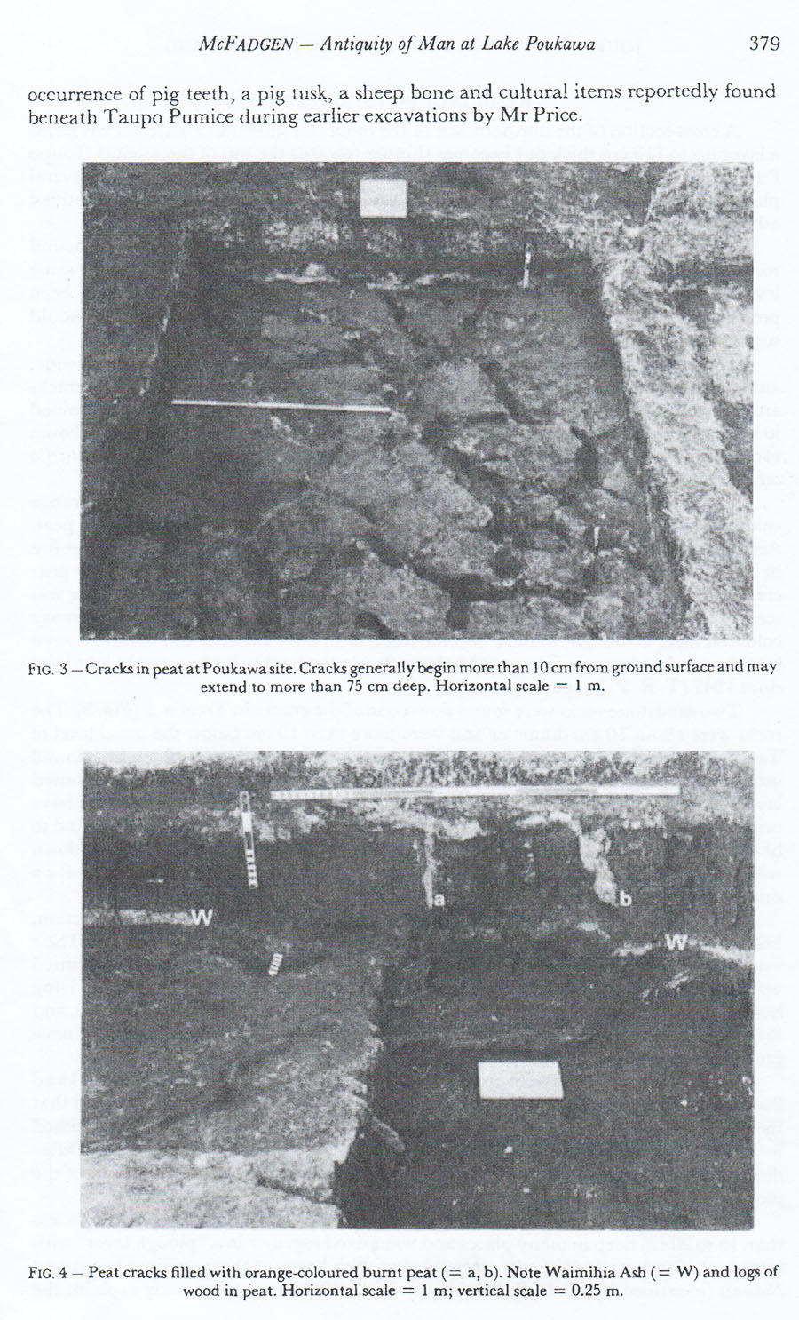
Note how carefully McFadgen has cleared the top debris off the fissured peat in Fig.3, leaving its top surface unscarred by tools, Thereafter the cracks have been carefully swept clean to accentuate their appearance for the camera shoot. Showing cracks, cracks, cracks was the whole purpose of the exercise.
These cracks will only occur where, previously, there was waterlogged peat that has been subsequently drained of its water content. These are areas that were substantially or permanently deep in water for a long duration, whereas the people lived up on the dry ground, which was not waterlogged and it would be unusual if the deeper subsurface peats ever cracked. The upper permanently-dry strata is where the broken-scratched-sawn bones, excavated by Price, were found, most of them burnt in cooking pits during ancient Moa hunter feasts.
The area of lakebed that was underwater in ancient times is not what was yielding the information which Russell Price was seeking.
McFadgen states: "A short distance below the surface of the peat is very fine-grained burnt, orange coloured layer".
According to farmer, Bill Buddo, this is the material you get when there is underground fire in the peat and would have happened after the lakebed was drained and sufficiently dried out. Bill Buddo states, ‘wherever there was a peat fire, Mr McFadgen would not have found satisfactory layers with which to understand the prehistory of the site’.
McFadgen states: "Features similar to post holes with grey coloured loamy fill were found below the Taupo pumice in lake sediment near the top of the mound".
On his Fig. 2 drawing he calls these “Root Holes”.
Bill Buddo’s comment when reading this in McFadgen’s report was, ‘He fails to say whether the Taupo pumice was an unbroken layer or not. He thereby fails to identify if it was ancient or new. Old root channels and peg or post holes will not look the same. Peg holes will be quite defined whereas old root channels will have more continuity to them over a longer distance.
McFadgen states: "Two sets of disc marks were preserved in the orange coloured layer in trenches one and two."
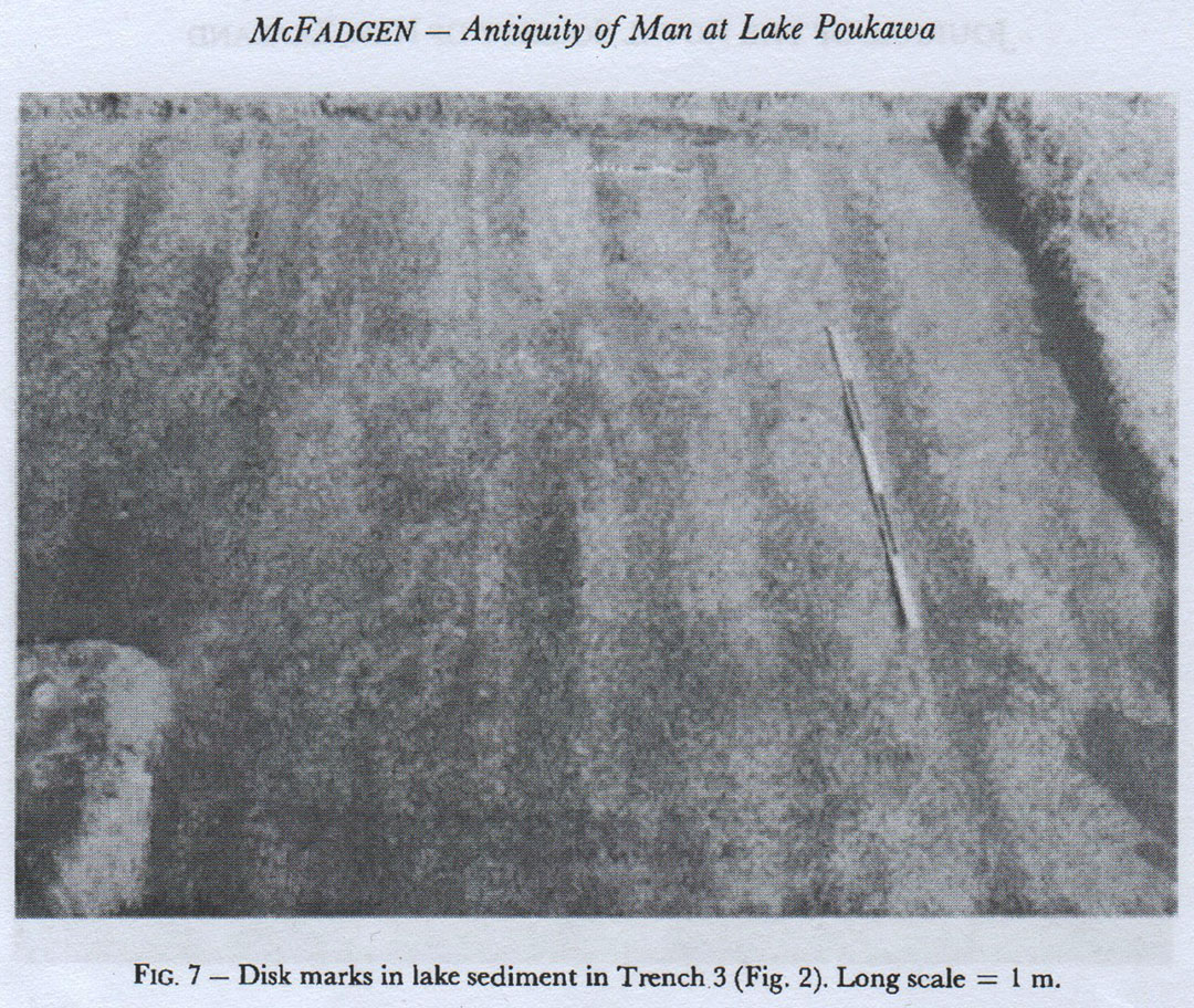
Again, in shallow, tiny trench 3, dug by McFadgen at the level of the former, below water lakebed, the base has been carefully manicured and swept, solely to accentuate the shallow disk marks. This is what the top of the fissured peat beneath would have looked like (Fig. 3) before he carefully excavated a small distance further down to clear and sweep out the cracks. He dearly needed to show cracks and disk marks in order to dupe the unsuspecting public that there was some substance to his very faulted hypothesis of similar cracking having occurred at all levels of terrain.
To which Bill Buddo’s astonished reply was, ‘What on earth was McFadgen doing in a mess of disk marks and orange coloured layers which represent burning? These are not the circumstances Russell price was digging in further to the south where he was able to show an unbroken Taupo ash layer as well as an unbroken Waimihia layer and could thereby be confident in what he was doing.
Bill Buddo adds: From the time the lake was drained, various plants took advantage of the changing circumstances. Fescue took over, and being a crowned plant, grew in big humps and clumps above ground. Cattle cannot be used to graze fescue, so every other tool which was available to the farmers was used. Disking, harrowing, fire and everything else, and it appears to be they tried pushing the fescue (an above ground plant) off the ground so it could be planted in better grasses.’
One could reiterate here that lightweight machines were used in the low areas to avoid any crushing of the fissured peat below the top humus layer. Some nearby farmers made the mistake of using wheeled tractors for harrowing and now formerly productive fields are crushed down and under water.
McFadgen pitches in with the comment "The disks disturbed material down to a depth of 15 to 20 cm".
Bill Buddo retorts with, ‘Mr McFadgen is still on the same spot which was guaranteed not to yield any satisfactory information. If he's going to write an archaeology paper on the basis that he was digging in a stupid place to prove some erroneous notion, then I only see that his work will be disproved in time, to come to be a waste of everybody else's time too. Russell price had already established from a similar, former lakebed spot adjacent the same useless results, so it beggar’s belief that Mr McFadgen would go there to try and prove anything other than something leading to the unfair destruction of Russell Price's work’.
McFadgen states: "In the plough layer a piece of bone was found on top of the mound".
To which Bill Buddo replies: This was probably just a sheep bone which makes it quite modern, and anybody working in the plough layer will not be an archaeologist, as there is absolutely nothing to learn there.
McFadgen comments: "Of the two fireplaces examined".
To which Bill Buddo replies: Mr McFadgen was looking for stones normally associated with Maori fireplaces. Somewhere along the line Mr McFadgen has not appreciated that we are dealing with different timescales, Maori during the last 1000 years B P, and ancient dwellers on the same site. All such fire stones in Poukawa, or other hard stones having special qualities have to be brought in from distant parts. So, they are significant in themselves. One would hardly go to the Ruahini's to bring in stones to make a lovely decoration around the fireplace. The ancient walking trails were pretty bad in those days and stones are quite heavy, so they’d have to be considered very precious to carry long distances. The local stone is limestone.
It's worthy to note that The Daily Telegraph newspaper on 12/6/1969, interviewed Price and reported the following: 'Three Types' ... Mr Price said that to date, by careful exploration, evidence has been unearthed at the site of three clear and distinct types of people. This had been gauged by the oven-stones they used - "these are all-important". On one part of the diggings, the oven stones were about four to five inches in diameter and were water rolled, clearly having come from a creek. Further along the site, the oven stones were all of sandstone collected from the area, and at the south end of the site, it was all standard greywacke river stone type. "All of these have an important significance," Mr Price said.
But the fireplaces that Mr McFadgen was dealing with also had peat fires through them as he mentions "the burnt orange coloured layer".
Bill Buddo adds: My experience over many years of Mr Price and his work, was that he would make sure he had an undisturbed layer of Taupo pumice, before excavating further down to scientifically consider what lay underneath. Mr McFadgen is very much at conflict with what I saw how Mr Price went about his archaeology work.
McFadgen mentions: "An examination of sections left by Mr Price through Maori midden". (See sketch plan C).
To which farmer Bill Buddo replies: Mr Price was not interested in Maori middens and I'm not sure how Bruce McFadgen got this muddled up.
McFadgen, in what must be the ultimate porky states: "Nowhere was cultural material found below undisturbed pumice".
Bill Buddo in justifiable irritation states: This is a complete fallacy, obviously Mr McFadgen did not sufficiently study the materials located by Price and his colleagues and the circumstances in which they were found or the ash bands they lay under.
McFadgen mentions: "Holes cut through pumice and filled with midden".
Here McFadgen is seemingly referring to his tiny dug holes F1 & F2, the low ground area that, 42-years previously to his 1973 whirlwind visit to Poukawa, was lake bottom. This area, years after the 1931 drainage scheme, was harrowed/ disked to remove encroaching surface fescue grass that has a very detrimental effect to cattle health.
The disking, undertaken by crawler tracked machines, was shallow, but sufficiently deep to reach the undulating, water-laid tephra ash contaminated with peat, and the fissured peat itself. The underlying fissures had caused some upper strata and objects to cascade downwards out of original situ, and this little gem of opportunistic knowledge became the foundation point of contention to suggest that everything Price had excavated, at higher levels and in permanently dry strata, was nothing less than mixed-up, topsy-turvy, unreliable material … an absolute misattribution and falsehood!
Bill Buddo states: ‘McFadgen’s mixed material is readily identifiable and can be immediately excluded from the results, and surely Mr McFadgen should have known that and acted accordingly if he had any actual archaeological or geological expertise.
Bill Buddo adds: ‘Russell Price was well aware of the Matai dominated forest, as there were large volumes of Matai seeds found in the peatlands of earlier times. The comments that McFadgen has to make about the beginning of forest clearance, as reported by McGlone, indicates that there was slash and burn agriculture going on in Hawkes Bay about 1000-years BP’.
As stated, McFadgen concludes that Maori didn’t even inhabit the Poukawa region until 150 – 300 years ago, and according to his illustrious colleagues, all Moa were extinct by the year 1400 AD … which is at least 300 - 450 years before there were supposed to be any people at Poukawa … so how does that work?
McFadgen’s Conclusion.
‘Because the peat is cracked and things have fallen down the cracks, and because the site has been bulldozed and disked, and bones and artefact's have been disturbed, the Poukawa site does not provide evidence for the antiquity of man in New Zealand, and is extremely misleading."
None of Price’s archaeological dig sites were ever bulldozed!
Bruce McFadgen displays ignorance of farming practices that must be stringently adhered to in the Poukawa Valley if the land is to remain in production. The former lakebed, transformed by drainage when the canal was finished in 1931, became valuable pasture land for dry stock, but remained delicate due to its surface proximity to the water table. One does not, willy-nilly, go onto this, largely, low lying land with heavy machinery, especially wheel tractors, due to the shrunken and fissured peat underneath, which can be easily compressed downwards. Farmers, David and Bill Buddo have religiously adhered to non-destructive practices, use only large-footprint crawlers over certain terrain, but can take utes or wheeled tractors, seasonally, onto the higher, humped-up or hillock ground of the Lake Poukawa basin.
Large sections of the foreground wetlands, not on either Bill Buddo’s or David Buddo’s farms, were once productive pasture, until the owners concerned allowed heavy machinery to work the land and thereby crush it downwards, thus returning it to lakebed status for much of the year. Likewise a local lady known to Bill Buddo allowed part of her farm to be leased and it too was subjected to cropping, where heavy machinery ruined it permanently, rendering it a swamp. Poukawa Valley is a little like Holland, requiring carefully monitored sluice gate maintenance of the terrain.
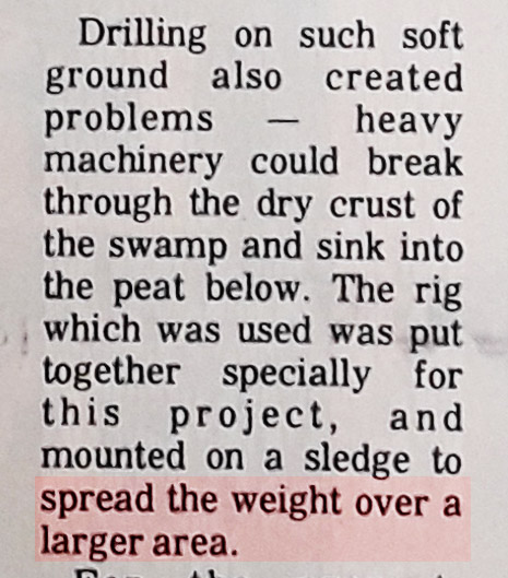
On 1/4/1982 the Hawkes Bay newspaper commented on a core drilling project being undertaken in the Poukawa Valley, which reiterated a well-known fact, and practice adhered to by responsible farmers like David and Bill Buddo ... On the low pastures only use appropriate machines that spread the load over a wide footprint and do no damage ... or kiss your pasture goodbye!
Bill Buddo disputes McFadgen’s false contention that any of the archaeological sites where Price dug were ever “bulldozed”.
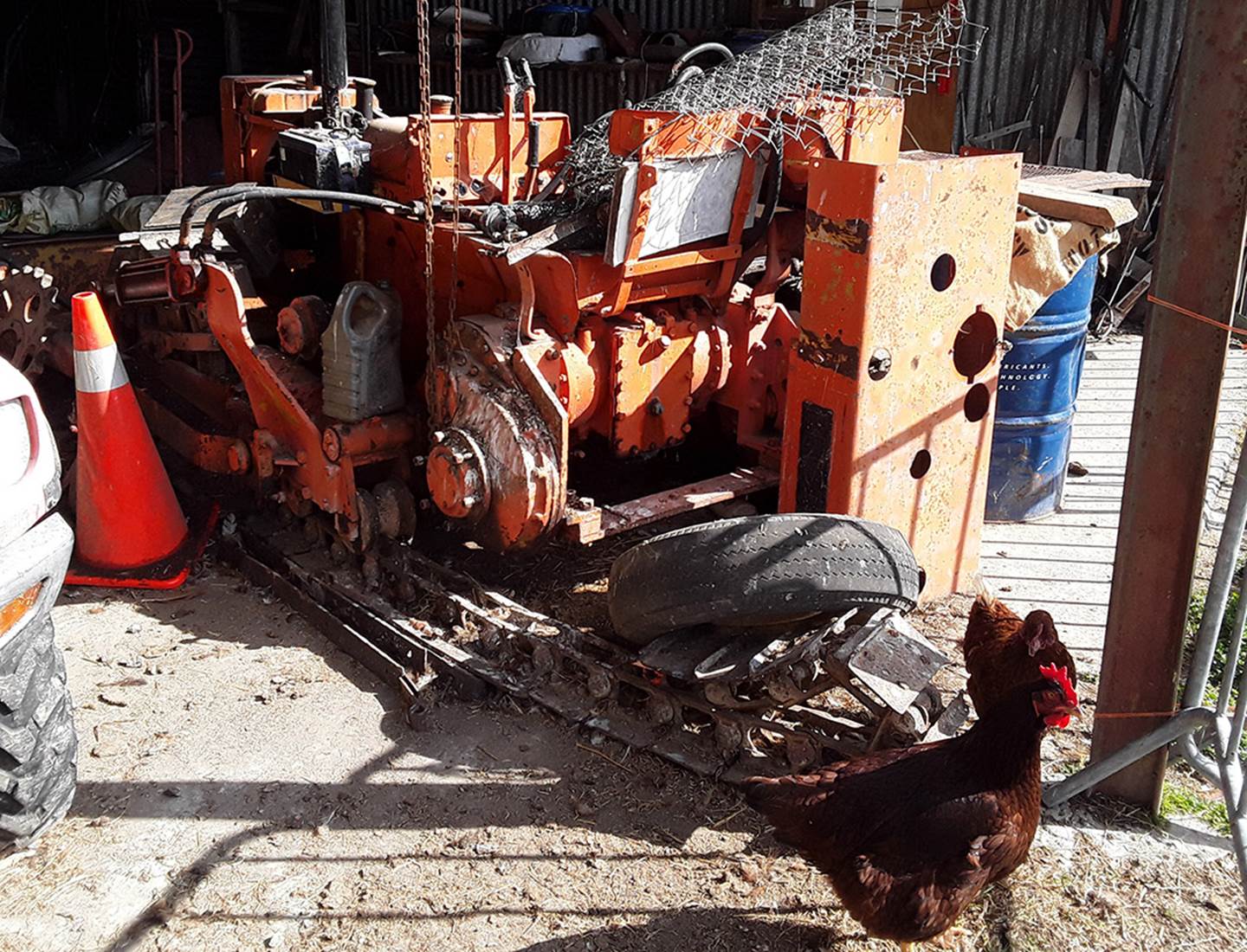
Here’s Bill Buddo’s little vintage, English Bristol crawler, undergoing a track and sprocket restoration, as time and opportunity avail themselves between multiple other chores. This machine has a blade, but only for such lightweight chores as driveway grading maintenance or scraping off surface fescue grasses at the height of summer in the delicate pastures of the farm. Fescue, when eaten by cattle, causes heart problems and must be eliminated from the pastures. Being that it is a shallow rooting grass it is easily removed by shallow disking or surface scaping with a big footprint, low impact machine like the little Bristol crawler.
There had never been any reason to do “bulldozing” on the farms, anywhere in the proximity of where Price’s several archaeological investigations took place.
McFadgen’s false contention that, ‘bones and artefact's have been disturbed’, by all this alleged “bulldozing” is also vehemently disputed by farmer Bill Buddo, as Price only conducted digs on permanently above water (for millenniums), solid and undisturbed ground. His area of interest was from the top of the solid cement-like cake of Taupo tephra downwards. The upper humus layer he considered to potentially contain Maori occupation material, so allocated a generously wide margin for consideration of Maori occupation, spanning many additional centuries, back to 186 AD. That this methodology was maintained is confirmed by Drs., A. Pullar (pedologist) or geologists H. Wellman, B Kohn and C Vucetich of Victoria University’s Geology Department.
Of McFadgen’s Acknowledgments. , where he mentions those who funded and lent support to his project, Bill Buddo says:
I'm very sorry to see that financial assistance was provided by the Victoria University Internal Research Committee, ‘Shame on you for having spent your public money on a hatchet job that had no scientific validity’.
It’s worthy to note that David Buddo, upon whose farm Price’s 22000+ bird bones and artefact's were stored for years, along with all the site records, saw with his own eyes the sawn, surface-cut-marked, cooked and burnt moa and other extinct bird bones that had lain under the undisturbed Taupo and Waimihia ash bands. Bill Buddo and a drove of others, including New Zealand’s leading scientists in the pertinent disciplines, saw the same proof and concurred that Price was correct in his hard-won conclusions about long-term human habitation of New Zealand.
Yes, shame on you Victoria University for having foisted this unqualified bunch of inept no-hopers onto us in 1973, with the obvious agenda of aborting the reasonable processes of scientific investigation … and thereby marching us backwards into the archaeological “Dark Ages”. Your unfortunate incentive has done a terrible disservice to the people of New Zealand and, If you had any integrity in 1973 or thereafter, you would have, instead, sent a team of unbiased archaeologists and geologists to work with Russell Price honestly and openly. … but of course that was never going to happen, as you knew full-well what you would find and it didn’t suit your political agenda … moral cowards and social engineers the lot of you!
Martin Doutré 29/9/19 ©.
GO TO THE NEXT SECTION TO SEE NEWSPAPER ARTICLES ABOUT ARCHAEOLOGICAL FINDINGS AT POUKAWA