THOMAS ATHOL RAFTER & THE DSIR CARBON DATING LABORATORY.
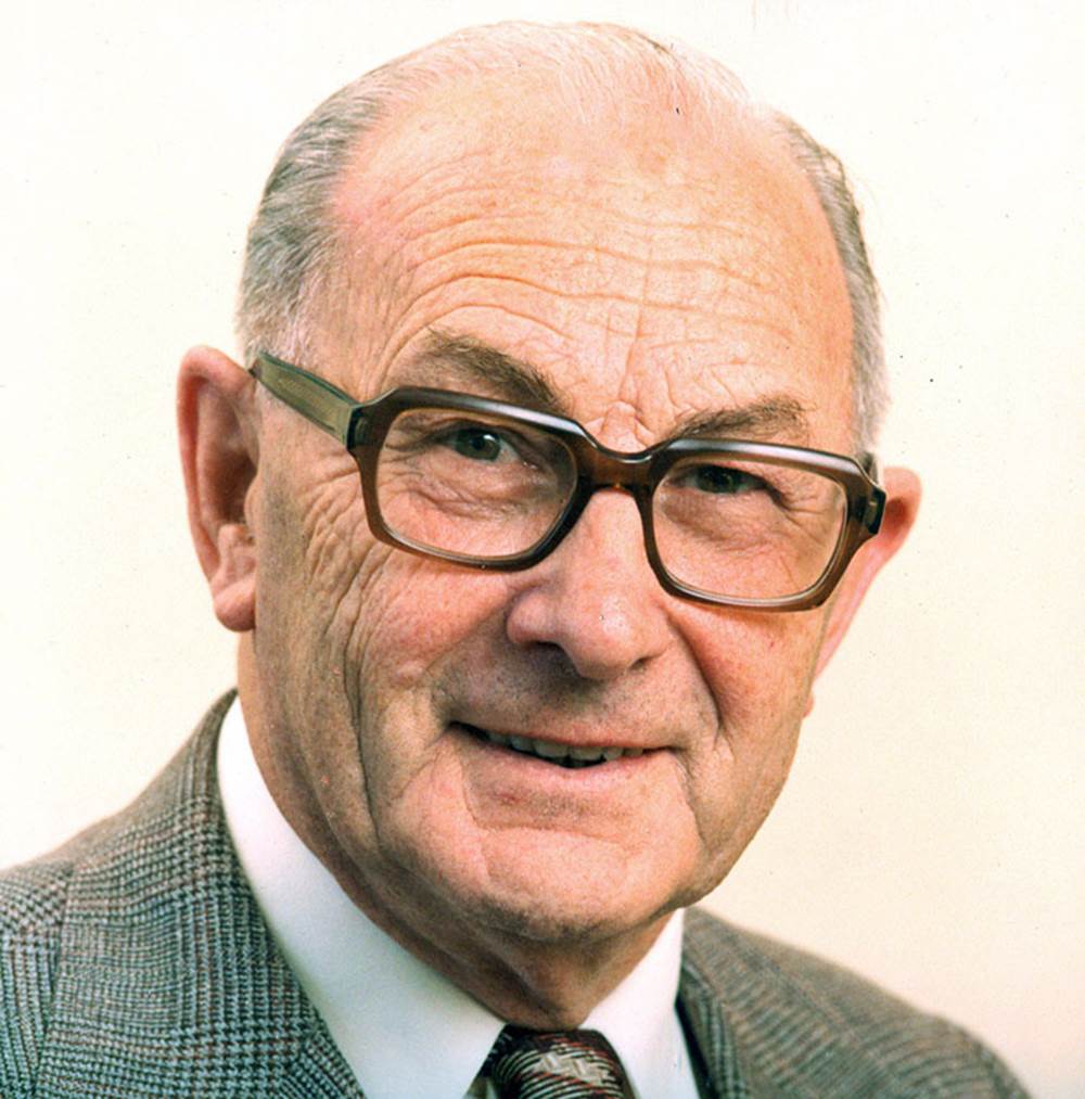
Among the seasoned professionals who played a major role in accurately fixing the dates of occupation for the Poukawa Valley was Thomas Athol Rafter, Nuclear Chemist, BSc (1935), MSc (1938), OBE, (1958).
One of the old school of true N. Z. scientists who religiously adhered to the, now extinct, “scientific approach” … unlike their more modern replacements who are obliged to deliver up only highly sanitised, politically-correct, cultural-Marxist, tampered-with results if they are to remain in their jobs. Scientific, archaeological or historical truths are now very rare commodities in New Zealand and about as available as the rare earth metal unobtainium.
‘In August 1948, as a result of a cabinet decision to establish a group of scientists in the DSIR to undertake nuclear research, Rafter was sent to study at the Massachusetts Institute of Technology and Columbia University, New York, and to visit nuclear establishments in the US, Canada and England. After returning he began to develop the new technique of radiocarbon dating, which relies on detecting the residue of a radioactively unstable form (isotope) of carbon (carbon-14) in organic materials. He initially used it to measure the ages of volcanic ash showers. The original paper on radiocarbon dating, published by Willard Libby in 1949, gave very little detail and used a method based on counting solid carbon-14. However, the process was so tedious and difficult that Rafter, DSIR physicist Gordon Fergusson and their assistants decided to investigate gas-counting techniques. After several months of frustrating work, they developed a technique using carbon dioxide gas, which provided radiocarbon age measurements to better than plus or minus 50 years – a major achievement for that time. He and his staff collaborated closely with New Zealand archaeologists in the dating of samples.’ (See: Dictionary of New Zealand Biography, by John R Hulston, 2000).
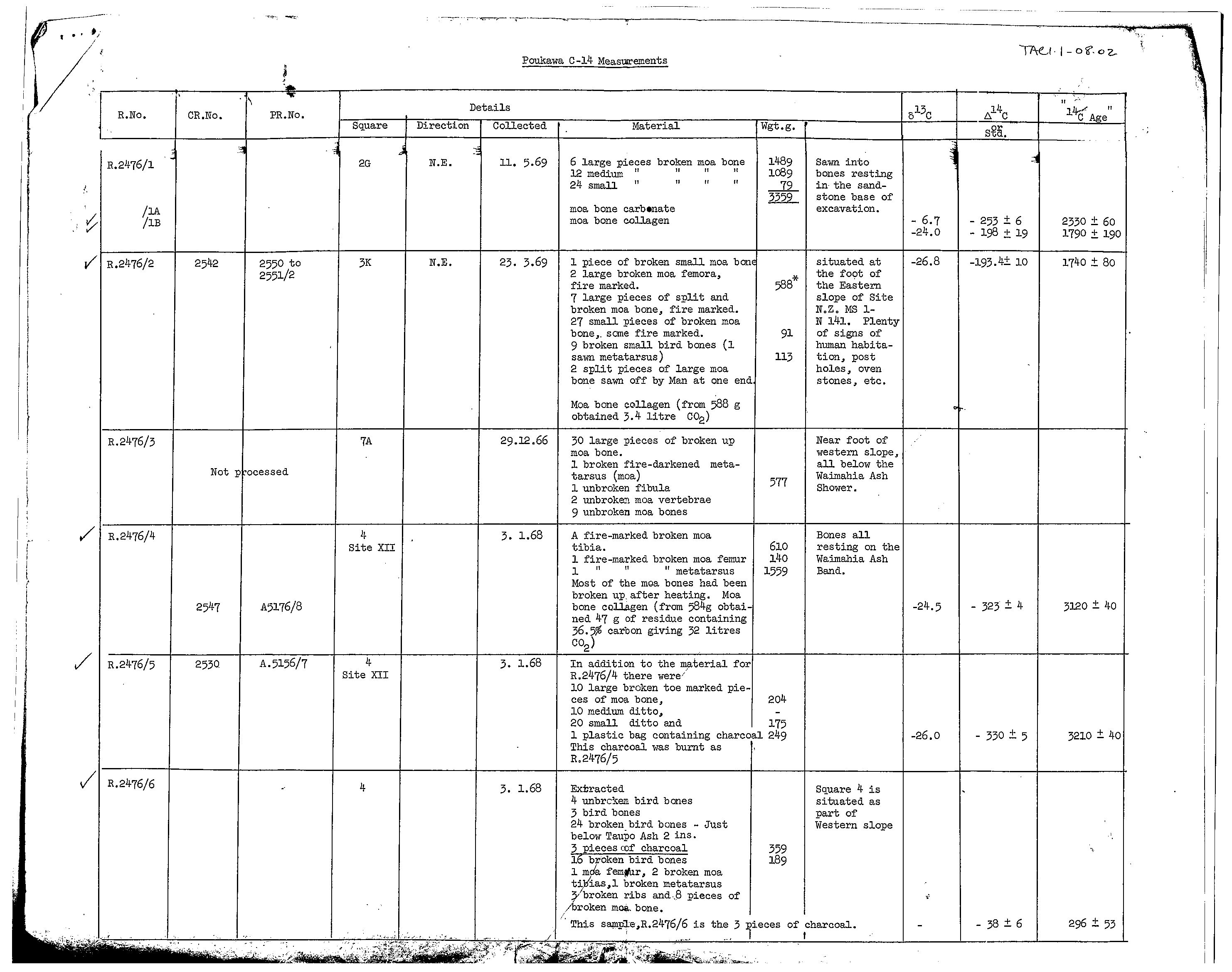
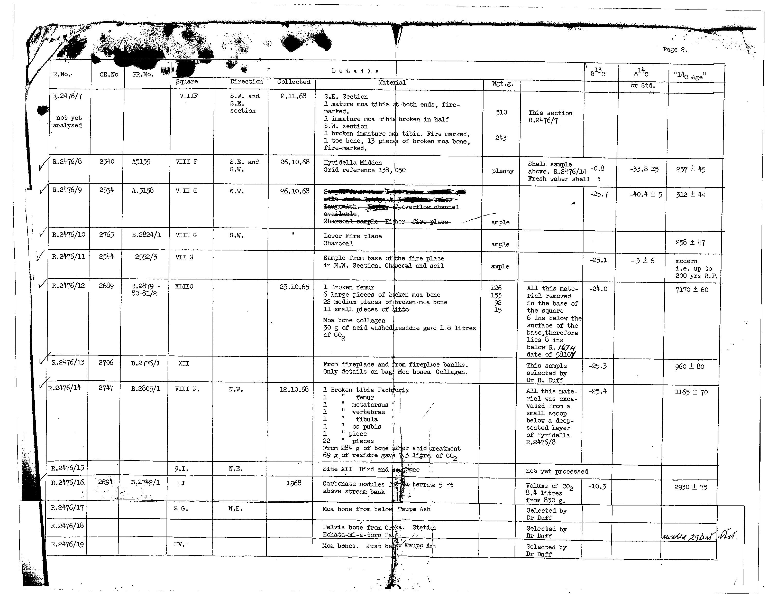
Here (below) are links to the C14 results that “he and his staff” concluded after very careful work in the DSIR Institute of Nuclear Sciences, Radiocarbon Laboratory.
To see some of these indisputable results of very ancient human occupation in the Poukawa Valley of New Zealand, go to the 3 links below and magnify the C14 sample figures for clear reading.
Poukawa Carbon Dating Results 1
Poukawa Carbon Dating Results 2
Poukawa Carbon Dating Results 3
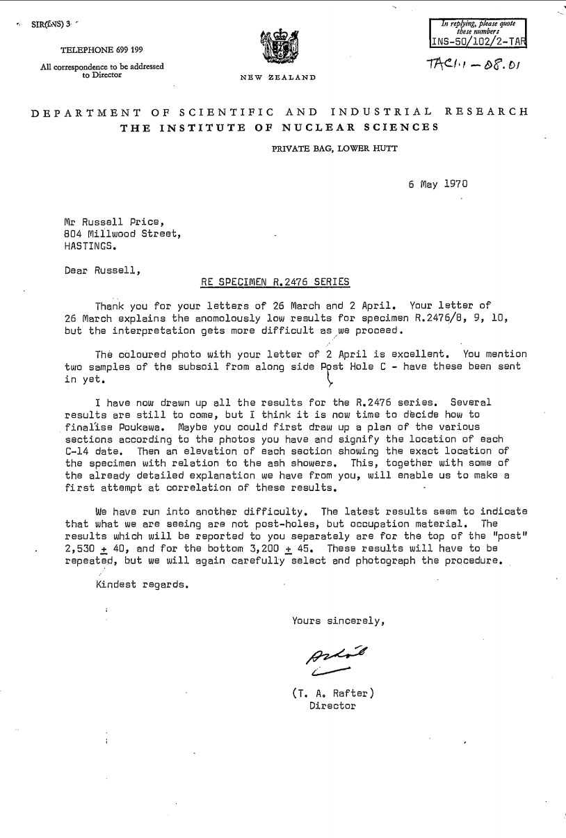
These results have never been scientifically refuted, although present-day trolls-at-the-gate within the nouveau Radiocarbon dating laboratory use a series of tactics to dissuade the very rare individuals who, by happen-chance, have stumbled onto some of the true results, from scrutinising or believing them. Amongst other ploys, lab management cite the newly imposed “current reporting conventions” criteria and infer that the 50-year old results are somehow wrong. They have also tried to impose an exorbitant financial penalty (up to $1500) on a person who wished to see the additional results mentioned by Rafter in his letter to Price, dated 6th of May 1970. After 3 futile attempts to get the 50-year old on-file information the enquirer had to resort to an Official Information Request.
With Thomas Athol Rafter at the helm of The Institute of Nuclear Sciences, Russell Price could rest assured that his 25-years of hard-won research results at Poukawa were well-supported by science, both in terms of tephra ash band stratification evidence and C14 results. However, in the turbulent political era of the mid-1970s and beyond, that was about to change and his indisputable, scientifically obtained results graduated to becoming a most unwelcome find.
The crucifixion of Russell Price began in earnest in 1978 via the release of an article under the name of a virtually unknown individual in archaeological circles named Bruce McFadgen. From what we can gather, a small group, including McFadgen, visited Poukawa 5-years previously and ingratiated themselves with Russell Price, who being ever-gracious to interested parties, was ever-willing to show people his dig sites and results. The visit is supposed to have taken place in August 1973 but neither farmers, Bill Buddo or David Buddo recall seeing people arriving at about that time and certainly never met Bruce McFadgen. They generally took no personal interest themselves in transient comings & goings, leaving the guided tours to Russell. However, this was supposed to have been a formal archaeological dig on David Buddo's farm, but permission to do so was neither asked for nor given.
In retrospect, David Buddo feels the whole affair surrounding McFadgen's dig activities was "sneaky" and discourteous. He should have been formally consulted!
In his October 1978 article McFadgen, who was qualified as a surveyor, with an MA in anthropology (environmental as opposed to physical, often referred to as social-anthropology and frequently criticised for its cultural-Marxist rhetoric) in 1973, released his report under the auspices of the Geology Department, Victoria University, where he was studying for a degree in geology by 1978. His report also represented him as being an employee of the N.Z. Historic Places Trust at the time of writing.
As it turns out, there is nothing to indicate that The Victoria Geology Department had any involvement, as McFadgen's alleged entourage was made up or Victoria University Geological Society and Wellington Archaeological Society as opposed to the actual "Department". So who were these day-trippers?
The Victoria University Geological Society is a social entity for staff and students interested in geology. Their mission statement says: Past events have included guest speakers, quiz nights, sports events, movie nights, field trips (including a trip this year to White Island), pub-crawls and student symposiums at GNS. So it’s looking more-&-more like we have a casual bunch of student and staff day-trippers out on a field trip to see Russell Price’s dig at Site N141/12.
The Wellington Archaeological Society is likewise a social entity, ‘with a membership spanning professionals, amateurs, students, organisations, businesses and institutions involved or interested in New Zealand archaeology and heritage’. Again, more day-trippers off on an adventure to check out Price’s dig and have a fun & informative tiki-tour of his site.
The Victoria University Internal Research Committee provided the funding for this caper. This ‘Joint Research Committee deliberates on matters relevant to the research portfolios of the Faculty of Education, Faculty of Humanities and Social Sciences and the New Zealand School of Music.’ In 1973 when McFadgen et al went to Poukawa, the Victoria University Internal Research Committee was allocated government funds for particular research projects and the Committee obviously saw this outing as important, sufficient to provide the funding. So, how much was spent to cover the costs of how many participants?
As it turns out, by 1970, the leading-lights of Victoria University Geology Department had visited Russell Price's sites and were unanimous that Price was correct. These individuals were H, Wellman, B.Kohn and C. Vucetich, also supported by pedologist A. Pullar.
It seems significant that the report was released after Dr. Thomas Athol Rafter retired in March 1978 from his long-held position as head of The Institute of Geological and Nuclear Sciences, later to be named in his honour as the Rafter Radiocarbon Laboratory. Dr. Athol Rafter had been an avid supporter of Russell Price’ work and had completed numerous C14 tests of Price’s bone, shell and associated organic finds, many of which lay beneath undisturbed ash bands of the Taupo and Waimihia volcanic explosions and showed clear signs of a human presence associated with them.
Although the largest percentage of Price’s carefully considered and chosen dig positions, at various far-flung sites across the farms, returned very good or outstanding results, there were at least two problematic areas that returned very confusing results when C14-age tested by Rafter at the lab.
Rafter had written to Price on the 20th of October identifying anomalous readings for samples earlier submitted for testing. Price then went on to explain in detail what was wrong with this dig position:
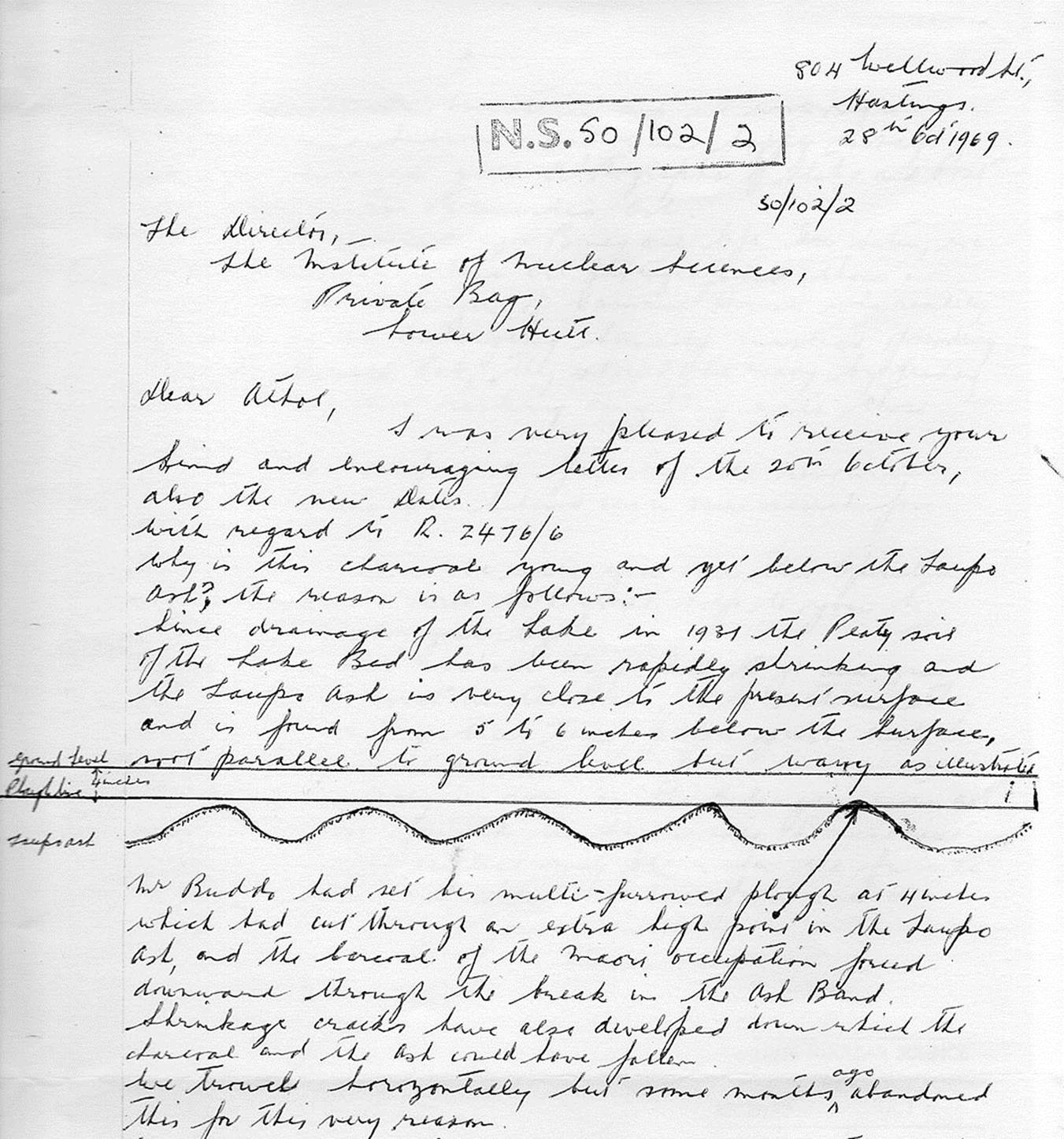
Dig site 2476/6 had formerly been situated on or straddling a flood plain that had been permanently under shallow water until 1931, at which time the new drainage canal lowered and stabilised the water level significantly. Thereafter a large section of newly drained land could come into pasture, thus increasing the availability of productive land considerably. However, the formerly sodden band of peat soil beneath had about 42-years to dry out and crack by the time Price dug a test excavation at square 2476/6. For those unable to decipher Russell Price’s handwriting in this letter, here’s the full text:
The Director
The Institute of Nuclear Sciences, Private Bag, Lower Hutt.
Dear Athol,
I was very pleased to receive your kind and encouraging letter of the 20th October about the new dates. With Regard to 2476/6
Why is this charcoal young and yet below the Taupo Ash? The reason is as follows: -
Since drainage of the lake in 1931 the peaty soil of the lakebed has been rapidly shrinking and the Taupo ash is very close to the present surface and is found from 5 to 6 inches below the surface, not parallel to the ground level but wavy as illustrated.

Mr. Buddo had set his multi-furrowed plough at 4 inches which had cut through an extra high point in the Taupo ash, and the charcoal of the Maori occupation forced downward through the break in the ash band. Shrinkage cracks have also developed down which the charcoal and ash could have fallen.
We trowel horizontally but some months ago abandoned this for this very reason.
We now remove turf from a square, then work downwards at the lower end of a square in a strip 18 inches wide and 9 ft long until we are about ½- inch above the Waimihia ash.
We then insert ourselves in this trench and work the square on a face, troweling downwards all the time and removing the worked over material with a fireplace shovel.
We have the Taupo ash under constant observation all the time and any cracks, stake holes or post holes can be detected at once. Those latter features can be photographed clearly in half section mantles by the Taupo ash and the peaty soil above it.
When this operation has been completed right up to the baulk line, we then go back to the lower end and repeat the process, then the Waimihia ash is under constant observation and we work right down into the subsoil, and I am happy to say we have secured good photographs of stake and post holes below the Waimihia ash.
In both operations major moa bones are left in situ, we work around them, these are photographed thus. I spoke to the manager of Camera House who readily agreed to do the enlarging himself instead of sending them to the lab. They should be ready by Friday night. I am not rushing anything with those negatives.
It is a great comfort to feel that the resources of the institute are behind us in our search for Poukawa Man.
Our thoughts will be with you over this operation and feel sure it will be a great help to you to regain the use of your leg.
Doug Pick and Michael King had to go and give our efforts a boost in the press. I told them they were only wasting their time, people just can’t grasp what we’re on to.
I will report fully as soon as the enlargements are ready and will forward the sawn into bones next week, and will outline my plans for the future.
Kindest regards and best wishes from us all
Yours sincerely,
Russell.
Price explains, both in a drawing and by writing, all of the factors that made this limited section of a site, or similar, low lying positions nearby, unsuitable for any extraction of valid results. Everything on the former lake bottom was topsy-turvy due to peat shrinkage and cracking, collapsing bits of the upper ash bands or charcoal and bones, etc., and cascading this foreign, upper matter down into the gaping peat fissures below. The former lake bottom site, drained of water in 1931,was an obvious non-event region for valid archaeological results and was abandoned accordingly.
However, anyone knowing that, here & there in the lowlands of Poukawa such sites existed, the opportunity could avail itself to, in sinister fashion, exploit their occurrence for gaining negative, contrary results. Such results could be, by innuendo and false association, used to unfairly reflect upon and misrepresent the totality of Price’s 25-years of careful archaeological work. Price certainly had naysayer enemies within the archaeological establishment ever willing to torpedo his amazing work and discredit his finds.
This appears to be what happened: By the time McFadgen et al commenced their digs at Poukawa in 1973, Price’s above letter exchange with Rafter had sat within government department records for 4-years and could well have been seen or shared by many government employees. It seems quite uncanny or suspicious that McFadgen, in his 1978 report, which appeared fully 9-years after Price explained the abysmal situation of site 2476/6 to Rafter, would include all of the same elements.
Both Price’s early account and McFadgen’s latter one 9-years later speak of the effects of the 1931 drain, the peat drying out and cracking below ground, cracks coming through the Taupo ash band layer … allowing surface charcoal or sundry objects to tumble down into and through the fissured peat, the effects of Mr. Buddo’s multi-furrowed plough cutting through the top surface and into the Taupo ash layer, thus spreading some to the sides, etc. Whereas Price saw no merit in continuing with such a site and abandoned it, McFadgen chose such a site for his archaeological probe that had exactly these negative attributes.
McFadgen’s results were solely his own and had no association with Price’s sites or the scientifically arrived at conclusions derived from them.
It begs the question, if McFadgen’s dig was done under some kind of supervision or involvement of Victoria University’s Geology Department, then why was such a stupid site chosen to undertake the work? Surely any geologist worth their salt would have quickly realised the site was palpably unworthy of investigation when it came to artifact age analysis.
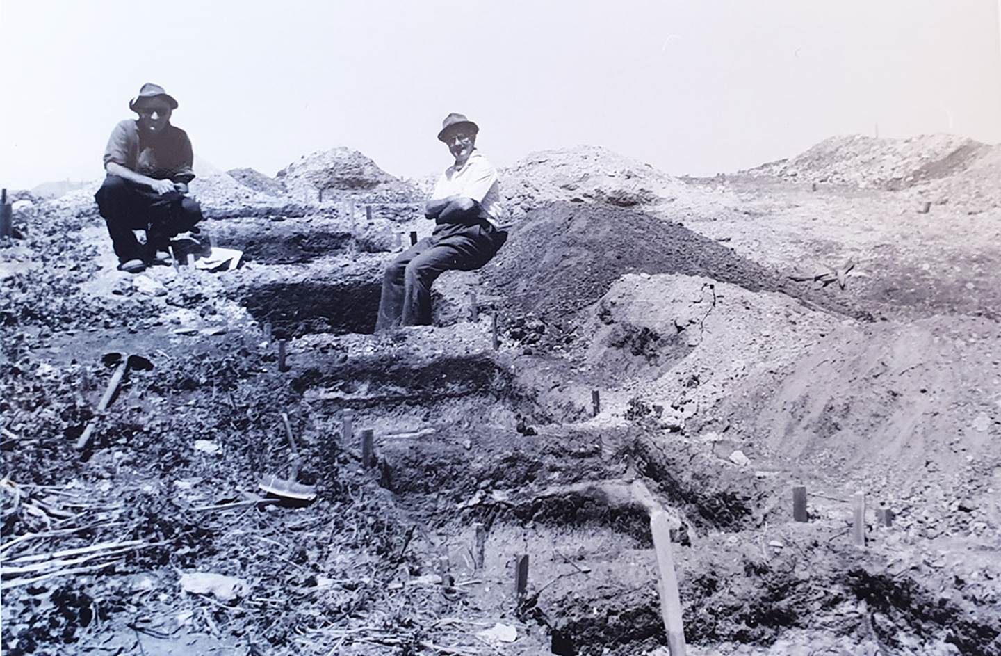
Price and his colleagues sought out only locations where the friable topsoil section, the Taupo sub-surface ash band, the peat soil band, the Waimihia ash band or further peat and blue pug layers at lower levels lay undisturbed. As a precursor when commencing a dig, they meticulously inspected the Taupo tephra band surface to ensure no cracks were visible, before descending down further through subsequent layers. The exact positions of items of interest (Moa bones, artefact's, etc.) at every level were recorded in the on-site logbooks.
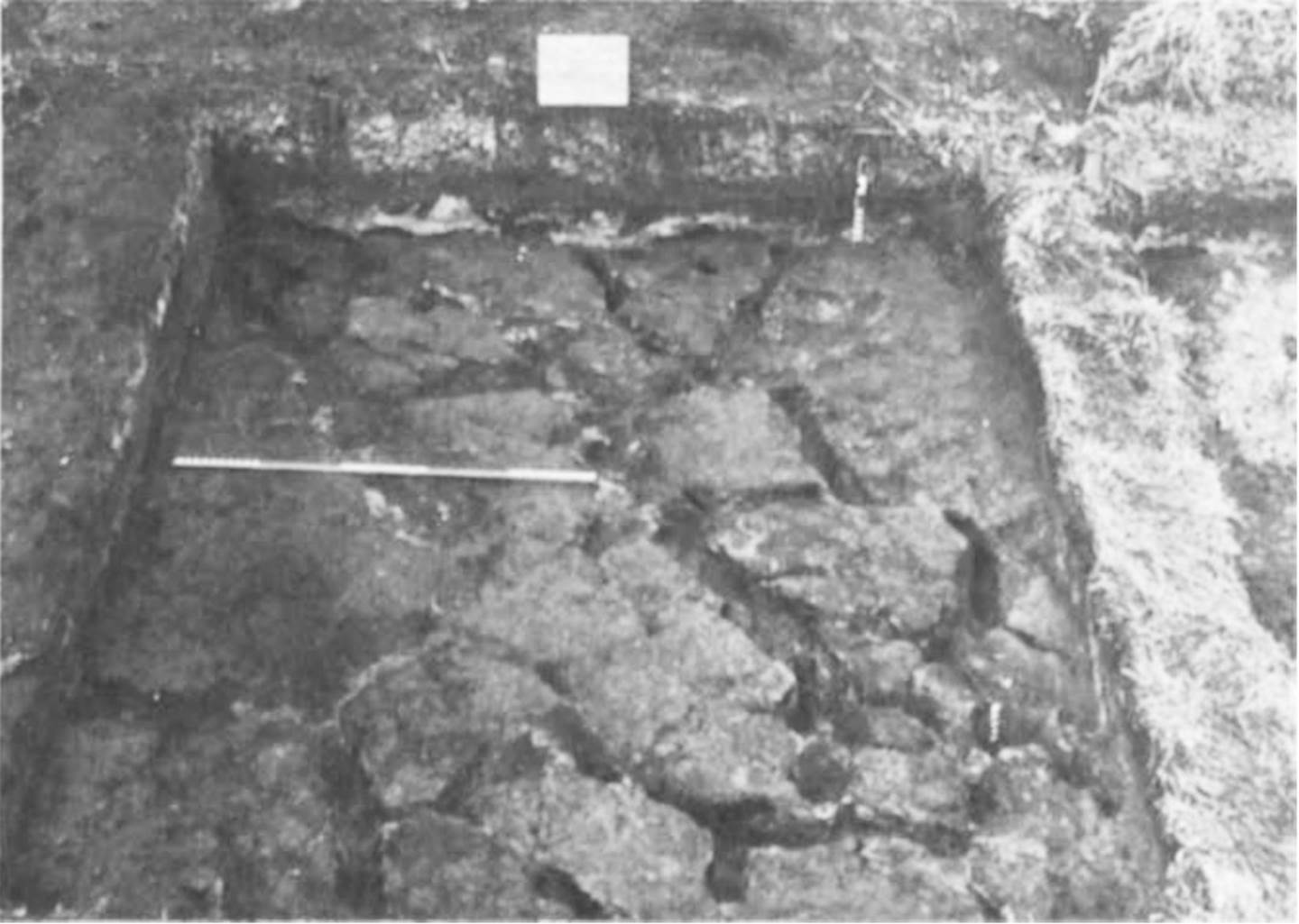
Photo taken from McFadgen’s, The Antiquidity [sic] of Man at Lake Poukawa, New Zealand, October 1978. Note the dried out and cracked peat-soil very near to the grassy top surface. On the background trench wall can be seen the whitened traces of waterborne pumice from the 186 AD ash fall of Taupo, which band sits very near to the grass surface. This location was most certainly under lake water until the 1931 canal was cut and the lake level lowered.
Note how carefully excavated this surface is, with no tool scrapes evident over the otherwise irregular surface of the fissured peat. Note also how the fissures have been carefully swept clean to expose and accentuate the cracks for the camera. The whole purpose of the exercise appears to have been to show CRACKS, CRACKS, CRACKS and, by false representation, infer that all of Price's excavations on humped-up dry land and through concrete-like, air-laid tephra ash, were similarly CRACKED, CRACKED, CRACKED.
Deceitfully, McFadgen omits to mention that a drove of eminent geologists and pedologists inspected Price's excavations and confirmed that cooked & broken up Moa bones, manmade artifacts, postholes and human bones were located beneath concrete-like, unfissured, volcanic-ash bands that sealed over everything that lay beneath. By their careful observations, no human occupation materials had ever migrated downwards through the ash bands to lower levels of strata.
Some of the leading scientists who inspected Price's excavations and are on record to have concluded the above are: Sir Charles Flemming (world renown Geologist - Paleontologist - Ornithologist -Zoologist), Dr Thomas Athol Rafter (head of the DSIR Radiocarbon Dating Laboratory, Dr Alan Pullar (Geologist - Pedologist of Soil Bureau, Whakatane), Dr Colin Vucetich (Geologist - Pedologist of Victoria University), B P Kohn (Geologist - Pedologist of Victoria University), Dr. Harold Wellman (Geologist - Pedologist of Victoria University), Dr Harry S Gibbs (DSIR soil scientist), Dr Ronald J Scarlet Osteologist), Dr J C Yaldwyn (Carcinologist - Osteologist - Marine Biologist - Zoologist of Dominion Museum) and many others including T L Grant Taylor & Eileen Tiller of NZ Geological Survey ( DSIR Soil Bureau), etc., etc.
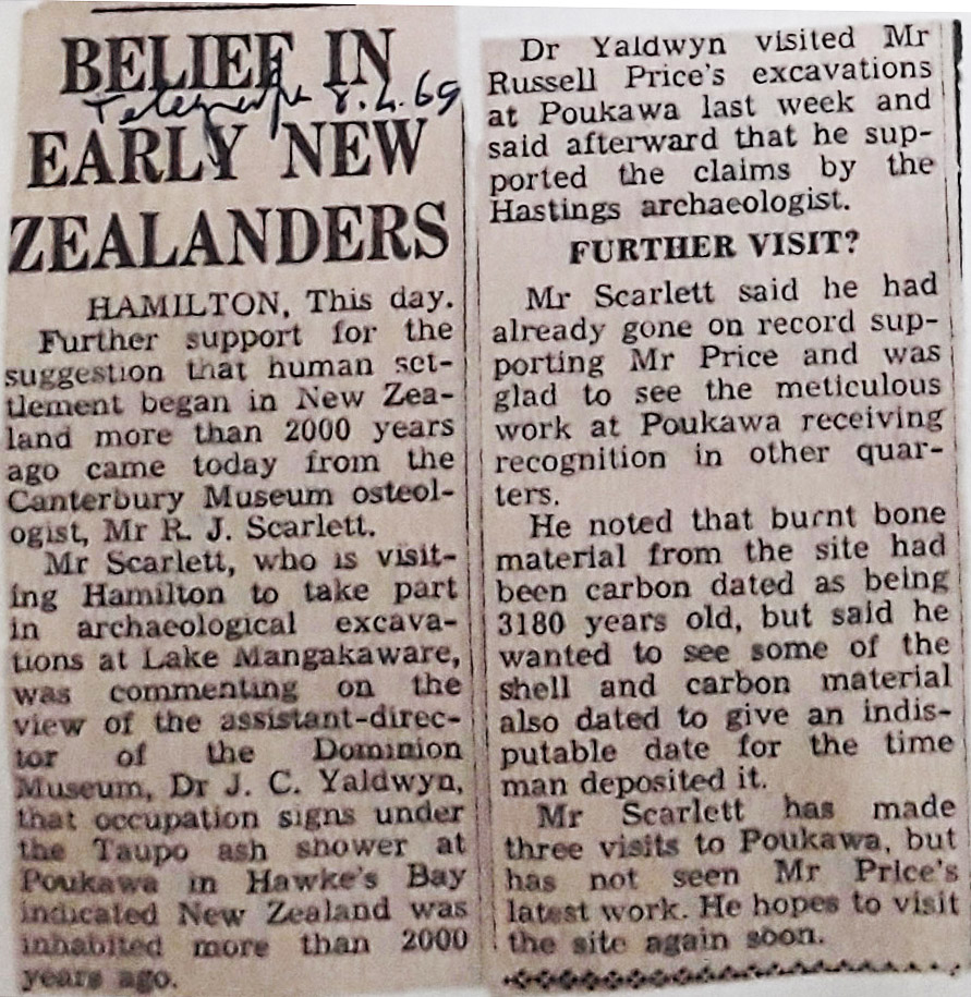
Newspaper article from the 8th of April 1969, documenting visits by two of the many leading scientists who, over several years, are on record for having inspected Price's excavations.
McFadgen's 1973 dig position was a grotesquely stupid site to choose if one was desirous to test the integrity of Russell Price’s evidence and conclusions … and whoever did choose it (for whatever purpose) wasn’t so much as a pimple on a genuine geologist’s or archaeologist’s arse.
SO, WHERE IS THE SPOT WHERE McFADGEN ET AL DID THEIR DIG?
These almost 50-years after the event we have little or no definitive evidence from the McFadgen camp as to the exact spot in the Poukawa Valley where his dig took place. He only says that it was at Site N141/12, which is an umbrella number for Russell Price’s main grid of exploratory trenches on David Buddo’s farm. All we have to go on are tiny, poorly drawn maps in McFadgen’s report, with the larger of the two having scale-bar measurements that are highly inaccurate. So, let’s see what we can do with them.
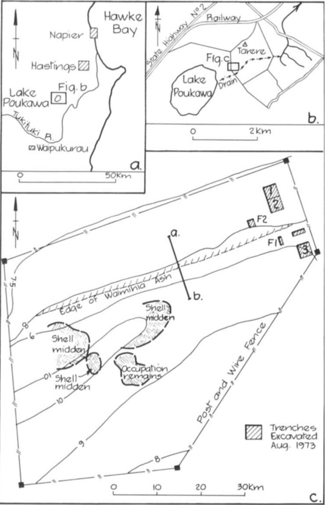
The small map (b) at the top right indicates a box in the Poukawa Valley where the dig took place and the larger map at the bottom (c) is the actual site map, showing McFadgen’s digs as boxes F1, F2, 1, 2, & 3. The scale bar is meaningless, so all one can do is guess positions based upon contour lines or the approximate positions of fence lines.
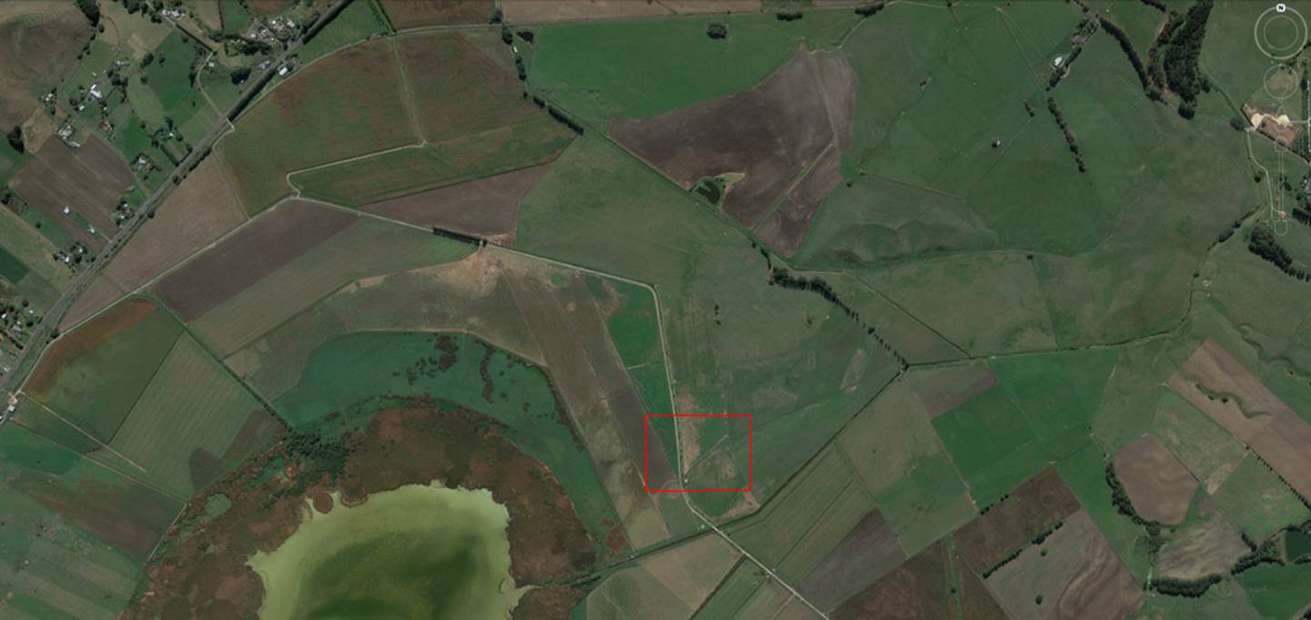
Based upon McFadgen’s small locating map box his dig was completed within the confines of the red rectangle shown. However, in a ground closeup within Google Earth, no such configuration of 5 surrounding fence lines, as found on McFadgen’s map (c), can be seen.
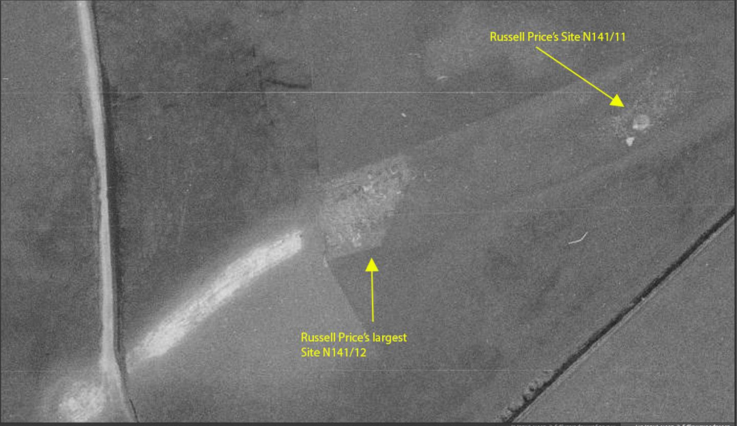
An old 1980 topographical map of Poukawa Lake and surrounding terrain shows the 5-sided enclosing fence set up in the late 1960s to protect Russell Price’s extensive archaeological digs from livestock damage on Site N141/12. He had also undertaken a dig at Site N141/11 in 1967 on a humped-up rise adjacent to farmer, David Buddo’s hay barn. From McFadgen’s map plan (c) we can see that he excavated beyond the NE extremities of Russell Price’s diggings of N141/12. (Image courtesy of Retro Lens.)
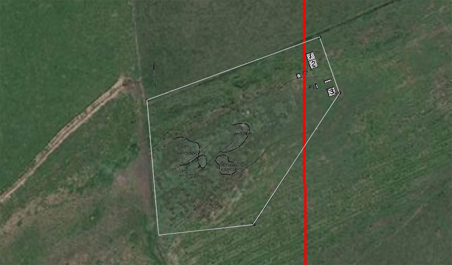
The McFadgen map plan was made into a transparency in Photoshop, scaled to fit the 1980 topographical photo’s fence line configuration, then the two layers accurately superimposed into Google Earth imagery. McFadgen’s plots (numbered white boxes) are seen to sit near the fence line that divides David Buddo’s farm from Bill Buddo’s farm. Terrain to the left of the vertical red line rises steadily to a much-elevated hump and it was over this eternally stable, undisturbed, raised ground area that Price conducted his digs. McFadgen’s dig sites (1 & 2) would have been under water till 1931 and his other marked boxes lay in similarly low terrain also. They therefore produced predictably dismal results … which seems to have been the whole purpose of, what can only be construed as, a nefarious, underhanded exercise to destroy Price by false association and innuendo.
The length of the top white line of the 5-sided fence containing archaeological site N141/12 is 260-feet or just over 79-metres.
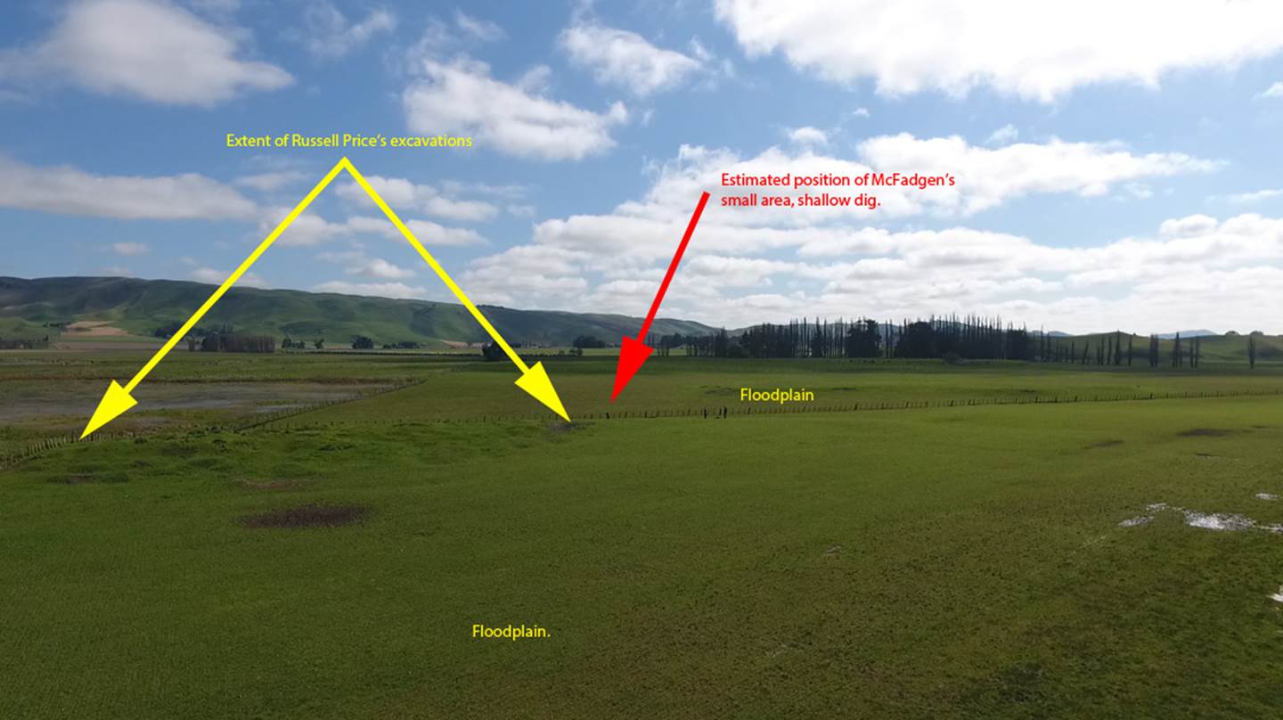
Whereas the very extensive excavation of Russell Price were done across a long raised hump of permanently above water ground, McFadgen’s tiny digs were beyond Price’s and down in the former floodplain.
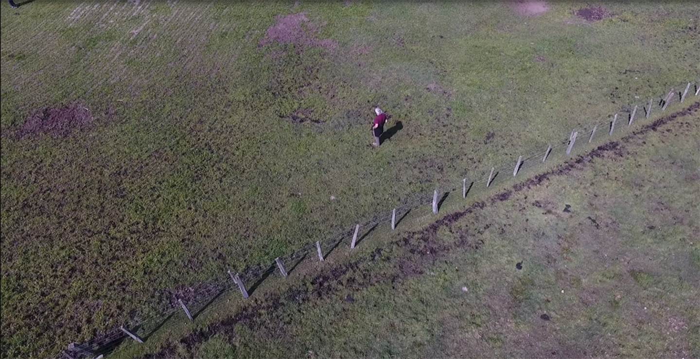
Killjoy was here! The author standing at or very near to the spot, down near the fence line, where McFadgen did his floodplain excavation. To the author’s right is the rising hump that still bears the multiple scars of Price’s meticulously organised, grid-line digs. The area in front of the author is the declining end of the humped ground, short of which Price’s archaeological excavations tailed off to nothing. McFadgen’s dig was external to Price’s zone and had nothing in common with Price’s work.
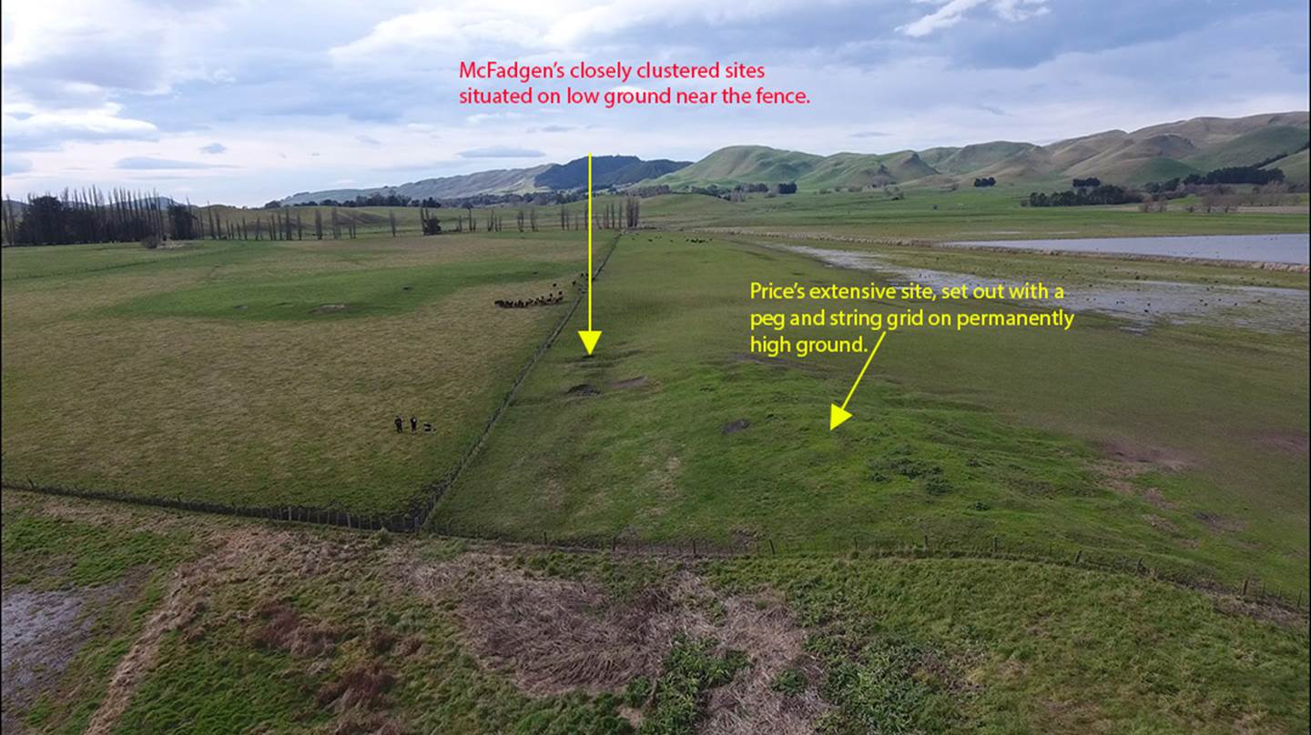
As can be seen from McFadgen’s map, his main archaeological probe (1&2) was undertaken on low ground near the fence line, whereas the comprehensive digs of Price were on permanently high ground, descending downwards to lower ground via long trenches. By this means Price achieved full cross section results overall, including at least 2 low ground, former wetlands, fissured peat results, similar to what McFadgen found in his very limited probe.
Russell Price saw this humped-up spur jutting into the lake as a likely spot for ancient trapping large wetlands birds (swans, etc.) including some Moa. His decision to dig here was based upon several decades of studying the Poukawa Valley topography and expert knowledge gained at 4 other digs he’d conducted around the valley.
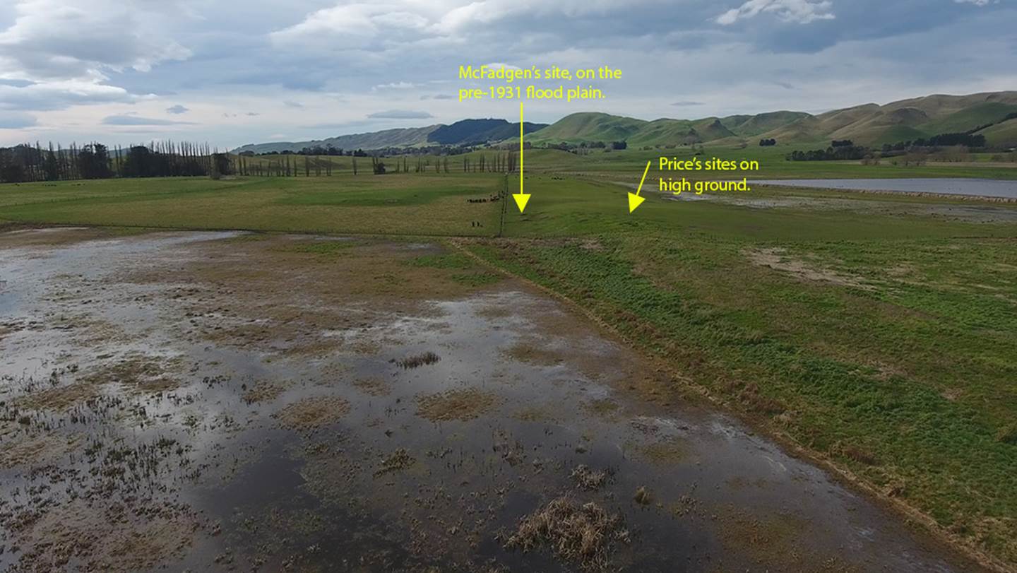
As can be seen from this August 2019 picture, lake waters can still lap the fence line. Before 1931, when the large drainage canal was completed, lake waters extended well beyond the fence and field and the shoreline was further up the sides of the raised ground peninsula jutting into the lake. When the canal was completed in 1931 the lake dimensions were reduced from 635 acres down to 280 acres. Lake Poukawa’s water level was dropped 6-feet in height, bringing into cultivation 3500 extra acres.
The reason McFadgen found cracked peat near the surface of his shallow excavations was because it had dropped its water, dried-out, shrunk and cracked in the 42-years between 1931 and 1973 when he conducted his all-so-sparse dig into the former lake bottom.
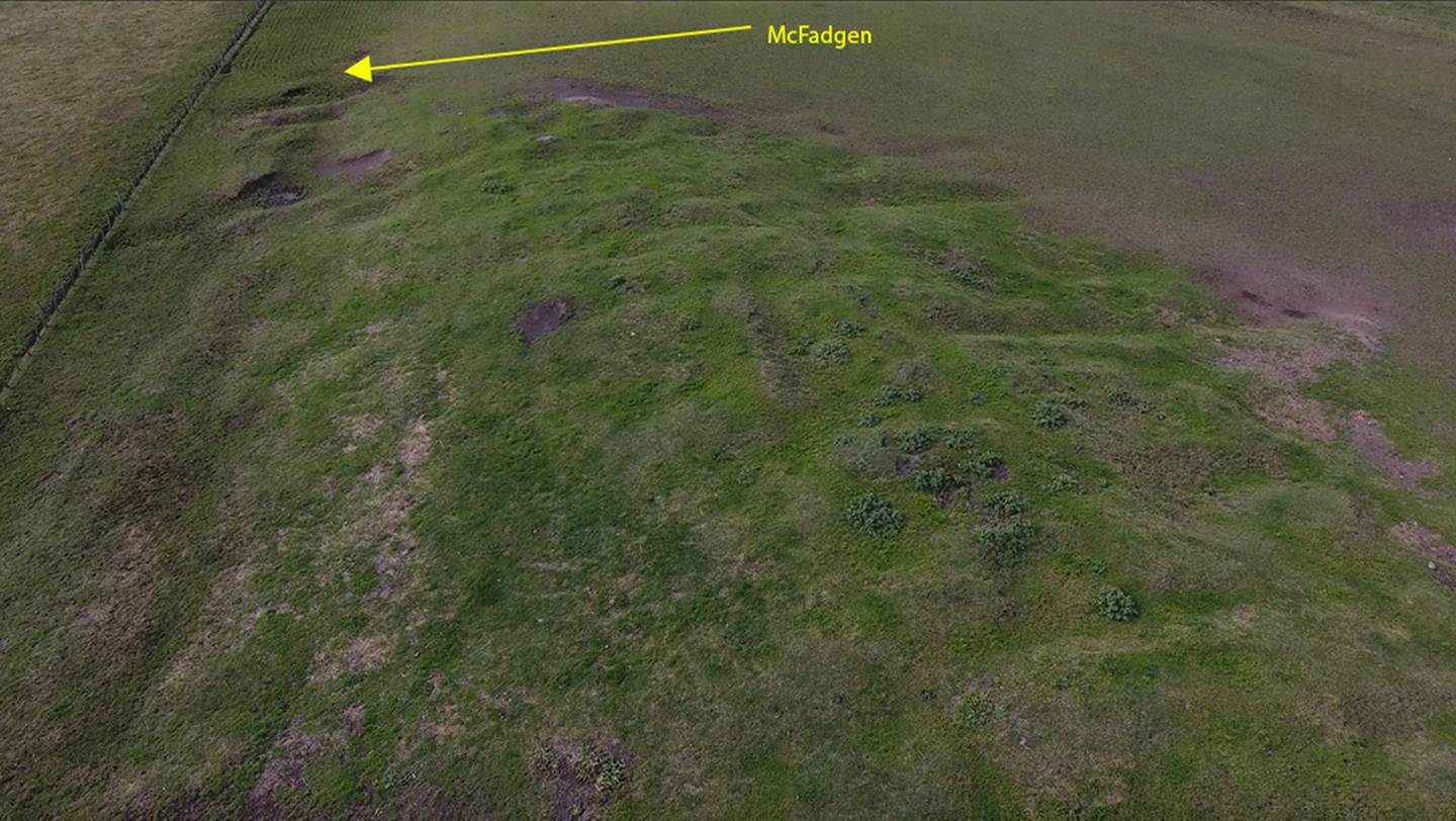
The much-rumpled terrain in the foreground was a site of years of hard work by Russell Price, a host of fellow workers and knowledgeable scientists of high-calibre. The arrow points to the approximate location of a small area where McFadgen and his associates did a shallow dig. Thereafter, poorly arrived at conclusions (reading like a jack-up) from that meagre, unscientific little probe were, by innuendo, fraudulently used to encapsulate or represent the totality of Price’s patently-more comprehensive work of many years duration, … work that had been verified and backed by leading New Zealand scientists.
False attribution can refer to:
The above pictures demonstrate just how farcical and preposterous McFadgen’s poison-pen, misattribution-slander of Price’s work and conclusions were, leading to its marginalisation and dismissal. Farmers, Bill and David Buddo, their parents, leading scientists, authors, friends and close associates saw how crestfallen and broken Price was in the last 5-years of his life following this unwarranted defamation of his careful work.
Ivan Cash, who met and worked with Russell Price wrote the following testimonial:
'When I joined the staff of Karamu High School in 1966 Don GOODALL on our staff encouraged me to come with him to meet Russell Price and both of us worked with him most week ends for almost a year. At this stage he had been working at the site for several years
We were intrigued by the sincerity and honesty of this man. He described himself as a retired farmer. He said that he just found things and let the experts tell him what he had found. However, it was clear during the time that we knew Russell Price that he was very astute and knowledgeable and observant and careful. We had tremendous respect for his careful methods of excavation and bagging material.
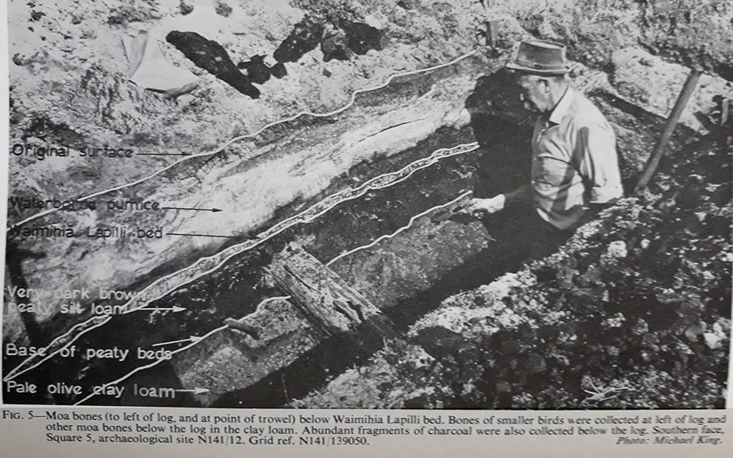
He had had the site surveyed and during inch by inch excavation using small sized plasterers trowels he left in foot-wide baulks to ensure that all his work could be checked at a later date., While working there I found a tuatara skull and pale apple-green moa egg shell fragments. Russell Price showed us the moa bone with three toes that bore deep cuts in its surface. He told us that he had excavated it from the blue pug clay below the intact Waimihia Ash shower. He said that material above and below it had been dated by the DSIR at 5280 years ago plus or minus sixty'.
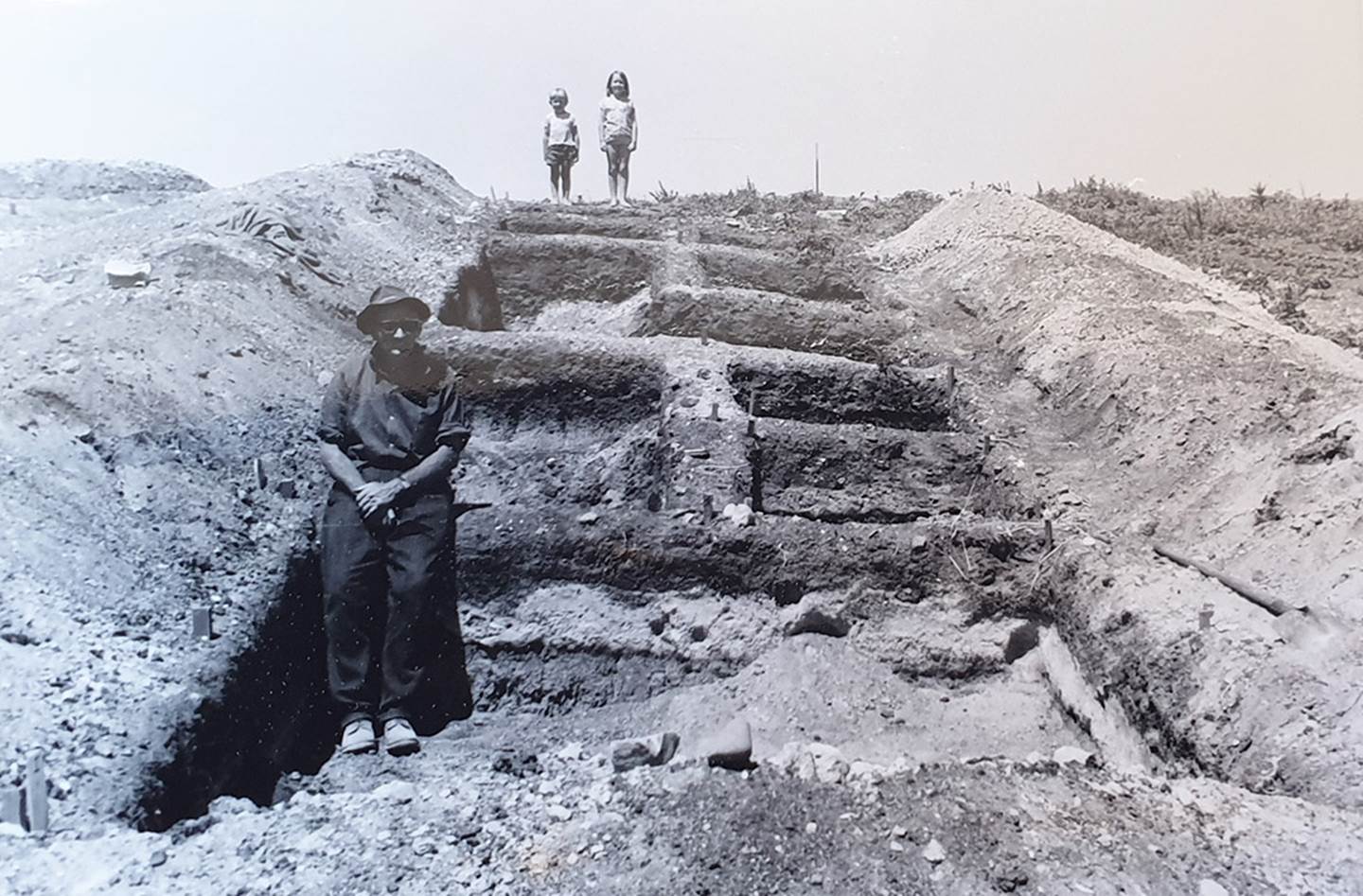
Note how extensive and labour-intensive these digs were. This is but one ”over the hump” dig, with many more adjacent. The cross-running baulk walls were undisturbed ground, left for future archaeologists to make their own careful assessments. Although the deep holes were in-filled to protect the sites, the baulk walls remain to this day, offering the opportunity for professionals in the fields of archaeology, geology and tephrostratigraphy, etc., to return to the site to draw their own conclusions.
Whereas McFadgen’s dig, along with his conclusions, was shallow, superficial and scientifically scandalous, Price’s many digs were deep, comprehensive and the information derived scientifically profound.
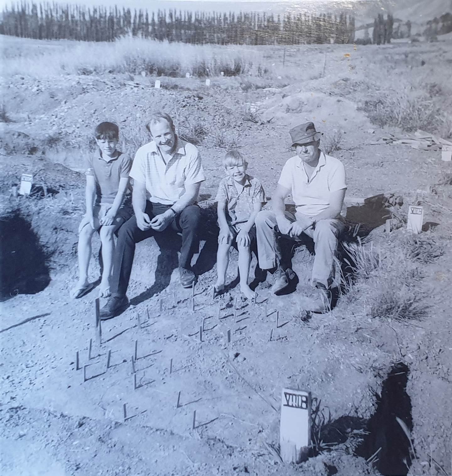
Farmer, David Buddo (right), his son Robert (middle) and family relatives amidst the demarcation stakes and section locating pegs of Russell Price’s massive dig. To their credit, the Buddo families, on adjacent farms, spent years supporting Price’s exhaustive efforts, only to see it all thwarted by McFadgen’s truth-challenged, dismissive article of 1978. Thereafter, those who had worked closely with Price “smelled a rat”, in realising just how entrenched, determined and vicious the academic adversaries, opposing Price’s findings, truly were.
Whereas a cursory look at McFadgen’s dig indicates he found cracked peat at about 1-foot (300 millimetres) below ground level at the lake-bed base of the hump , the Price team at site N141/12 did deep, long excavations across the higher, permanently-above-water ground and found solid peat. Had McFadgen wanted to do a proper, intelligent dig across the higher terrain or even carefully check Price’s trenches and baulk walls traversing an entire cross-section, the inescapable conclusion could only have been that Price was correct … but it doesn’t seem McFadgen, unqualified, as far as anyone can ascertain, to be there in a credentialed archaeologist's role (1973), wanted to arrive at that scientific consensus of opinion.
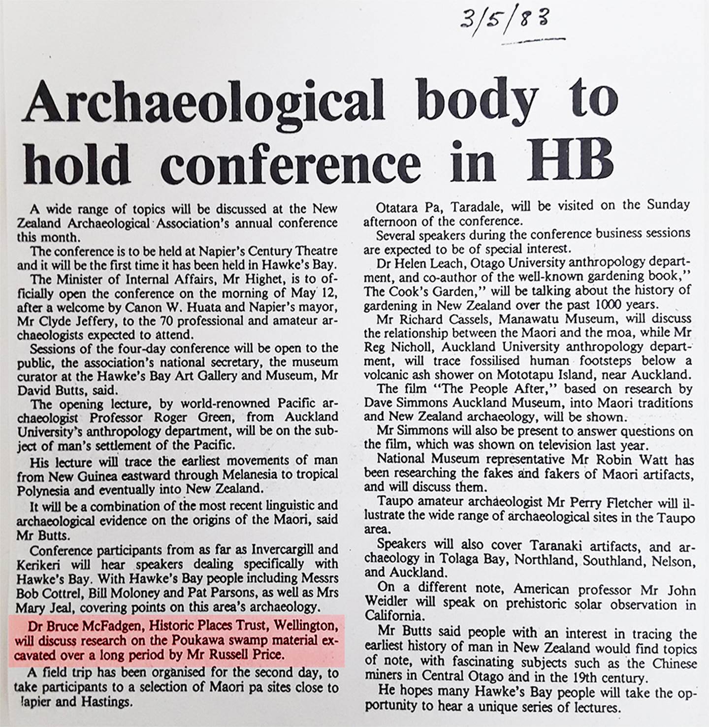
To add insult to injury, on the 3rd of May 1983 the Hawkes Bay newspaper announced the upcoming conference of the New Zealand Archaeological Association, to be held at Napier’s Century Theatre. Amongst the line-up of speakers, the newspaper stated that: ‘Dr. Bruce McFadgen, Historic Places Trust, Wellington, will discuss research on the Poukawa swamp material excavated over a long period by Russell Price.’ … which, for this writer, recalled to mind the gutless, psychotic murder of musician, John Lennon in 1980 by Mark Chapman, who shot him in the back multiple times. Attention-seeking Chapman, craving Lennon’s fame, was convinced that if he could kill Lennon then he could become Lennon, assuming his entire identity and persona.
Ten years after McFadgen visited Poukawa, qualified at the time only as a surveyor, and five years after releasing his sparse report, he’d now achieved a doctorate degree (1979) and all of the kudos befitting a lettered scholar who had championed the cause of destroying Price’s credibility in the eyes of his naysayer peers. We can only surmise that he became the darling of the social-engineers, having slain the ominous dragon.
How very ironic and obnoxious it is that the very person who, with no real archaeological evidence, stabbed Russell Price in the back then got invited to fill Russell’s shoes at the NZAA conference podium and pontificate, as the leading authority in all things “Poukawa”, while the hometown boy didn’t get a look-in. McFadgen was, vicariously, elevated to becoming the new Russell Price.
It’s amazing how McFadgen’s career soared within a few short years after he torpedoed Price and the aligned scientists. Now he seems to be in charge of everything … strange that! … some stars are in ascension while others are in decline.
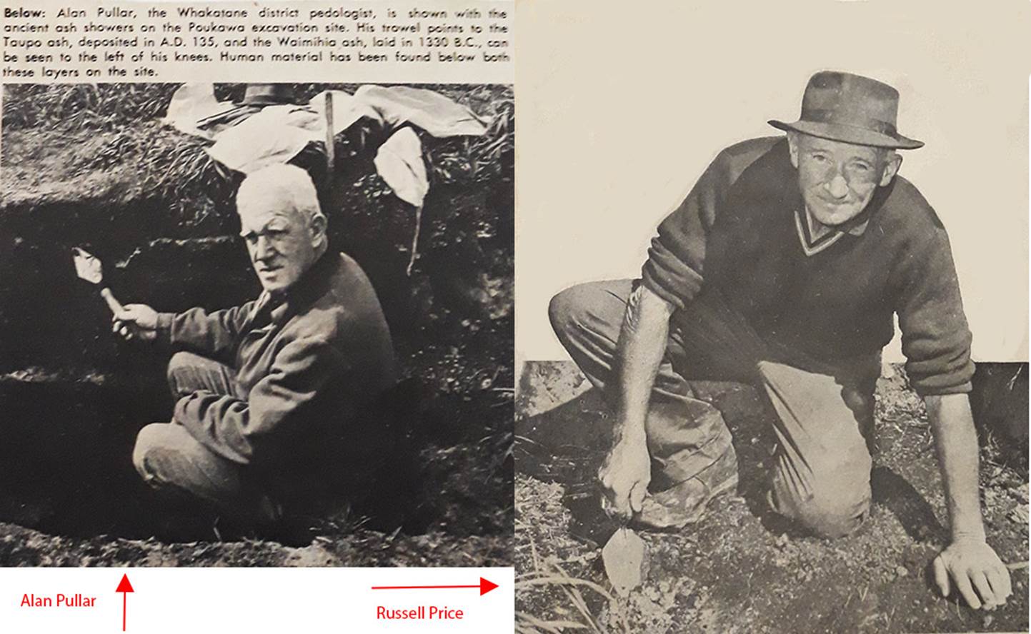
Alan Pullar, scientist of the top order from the DSIR Soil Bureau fully verified that Price had found both human material and human related material beneath the ash bands. In this conclusion he was supported by Collin Vucetich (DSIR), Dr. Athol Rafter, head of the DSIR Radiocarbon Laboratory, Dr. C. A. Fleming, New Zealand’s leading geologist, Professor H. W. Wellman, geologist/surveyor, Michael King, NZ Archaeological Association & historian and many other leading experts in their fields, three notable ones of which were affiliated with Victoria University’s Geological Department.
Alan Pullar wrote a scientific paper about the amazing discoveries at Poukawa titled : Pumice Ash Beds and Peaty Deposits of Archaeological Significance Near Lake Poukawa, Hawkes Bay By W. A. Pullar, Soil Bureau, Department of Scientific and Industrial Research, Whakatane, Appendix 2 by P. L. Searle, Soil Bureau, Lower Hutt, Appendix 3 by Bruce Marshall, Whakatane, New Zealand, 20 July 1970. (Tragically, when one enters this title into Internet-Search, no link takes one to a digital copy, but instead delivers up McFadgen’s scientifically defunct, Antiquidity [sic] of Man at Lake Poukawa hatchet-job as an alternative).
After the sparse and ridiculous McFadgen article was used, by the gaggle of this-must-not-be-so naysayers, to destroy the conclusions of New Zealand’s most illustrious scientists supporting Price’s work, W. A. Pullar became totally disillusioned with the abysmal, unscientific state of NZ archaeology.
As it turns out, NZ archaeology has never recovered from the hijacking, coup d’état of the cultural-Marxist element, who have further clamped down on what the public can or cannot see or know. Nowadays all findings must reflect the agendas and goals of the political organs and expound only the view that Maori, arriving from Eastern Polynesia in circa 1300 AD (700-years ago), are the solitary people ever to occupy the country pre-colonial. This unsupportable nonsense flies in the face or what the learned Maori elders told us for over 150-years, as well as a vast accumulation of archaeological evidence researched since the dawn of the colonial era.
THE STATEMENT OF BELIEF
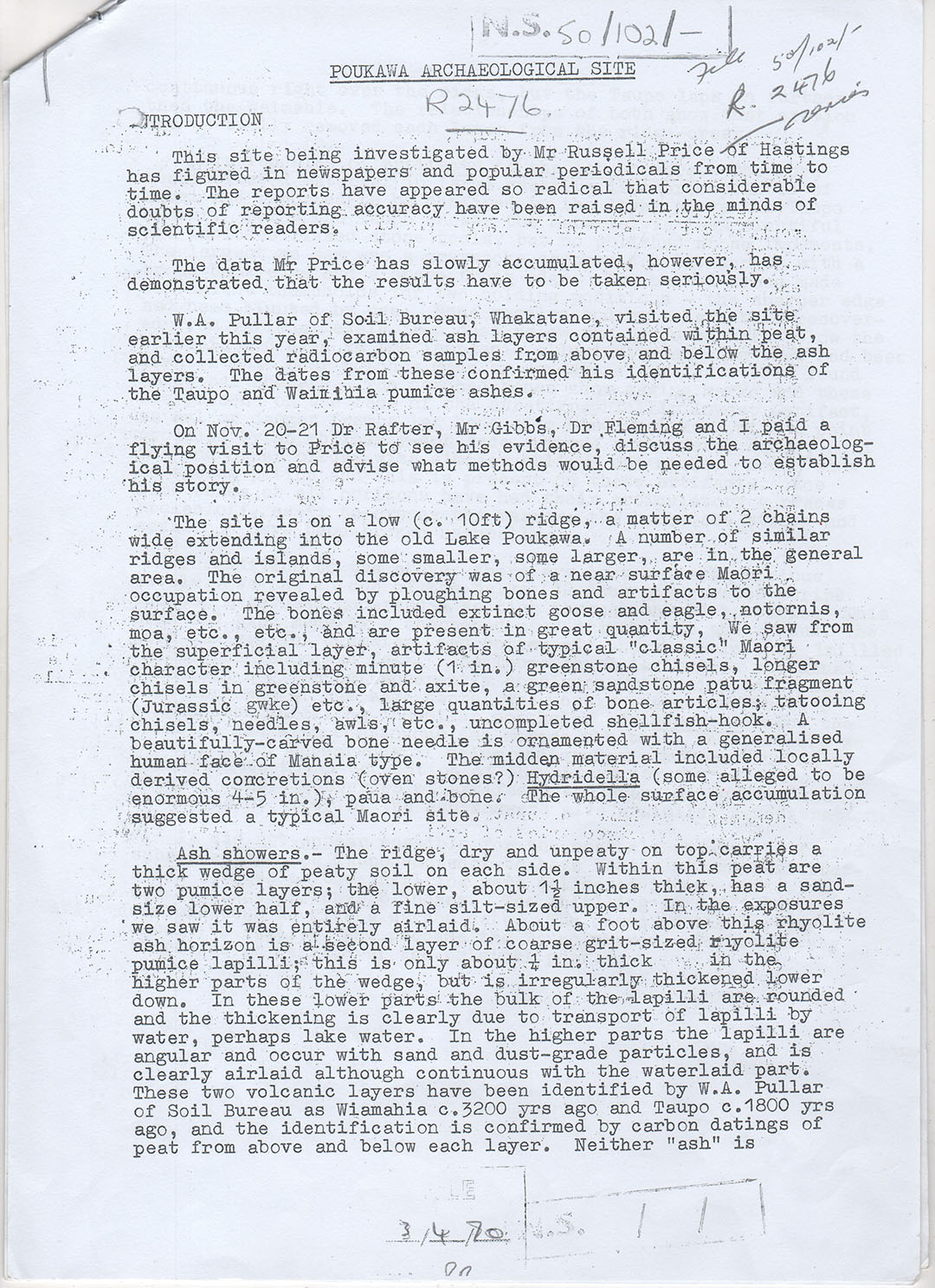
'What almost nobody realised in the late 1960s is that a hard core of top scientists who had visited the Poukawa site were totally behind Price and Pullar. They could see the obvious. However, to openly stand beside these two would have cost them too much so they did the next best thing. A number allowed their names to be associated with a secret 'Statement of Belief', marked across the top 'RESTRICTED - NOT FOR PUBLICATION'. And because it vindicates Price and Pullar, and because the conclusions drawn go way beyond what these two could ever have envisaged, parts of it will be quoted now in such a manner as to leave the writers unidentifiable - with two exceptions. In order to demonstrate the high-level nature of the Statement it should be known that both Drs Fleming and Rafter had a hand in its composition...'
'The data Mr Price has slowly accumulated...has demonstrated that the results have to be taken seriously', the Statement began.'
'W A Pullar of Soil Bureau, Whakatane, visited the site earlier this year, examined ash layers contained within peat and collected radiocarbon samples from above and below the ash layers. The dates from these confirm his identification of the Taupo and Waimihia pumice ashes'
'The controversy over 'water-laid and air-laid ash was settled in a few sentences...'
'Within the peat are two pumice layers; the lower about 1½ inches thick, has a sand-size lower half and a fine silt-size upper. In the exposure we saw it was entirely air laid. About a foot above the rhyolite ash horizon is a second layer of course grit-sized rhyolite pumice lapilli; this is only about ¼ inch thick in the higher parts of the wedge but is irregularly thickened lower down. In these lower parts the bulk of the lapilli are rounded, and the thickening is clearly due to transport of lapilli by water, perhaps lake water. In the higher parts the lapilli are angular and occur with sand and dust grade particles and is clearly air-laid although continuous with the water-laid part'.
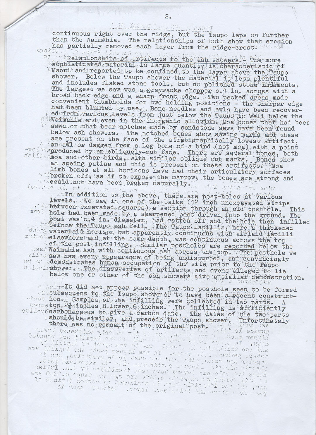
'A series of Post holes at all levels also spoke eloquently to the scientists. Speaking of one such hole the Statement says that...'
'The post was ca 4" in diameter, had rotted off and the hole then in-filled before the Taupo ash-fall...Similar post holes are reported below the Waimihia ash with the ash continuous across the top...The post hole we saw has every appearance of being undisturbed, and convincingly demonstrates human occupation of the site prior to the Taupo shower...The discoveries of artefact's and ovens...below one or other of the ash showers give a similar demonstration'.
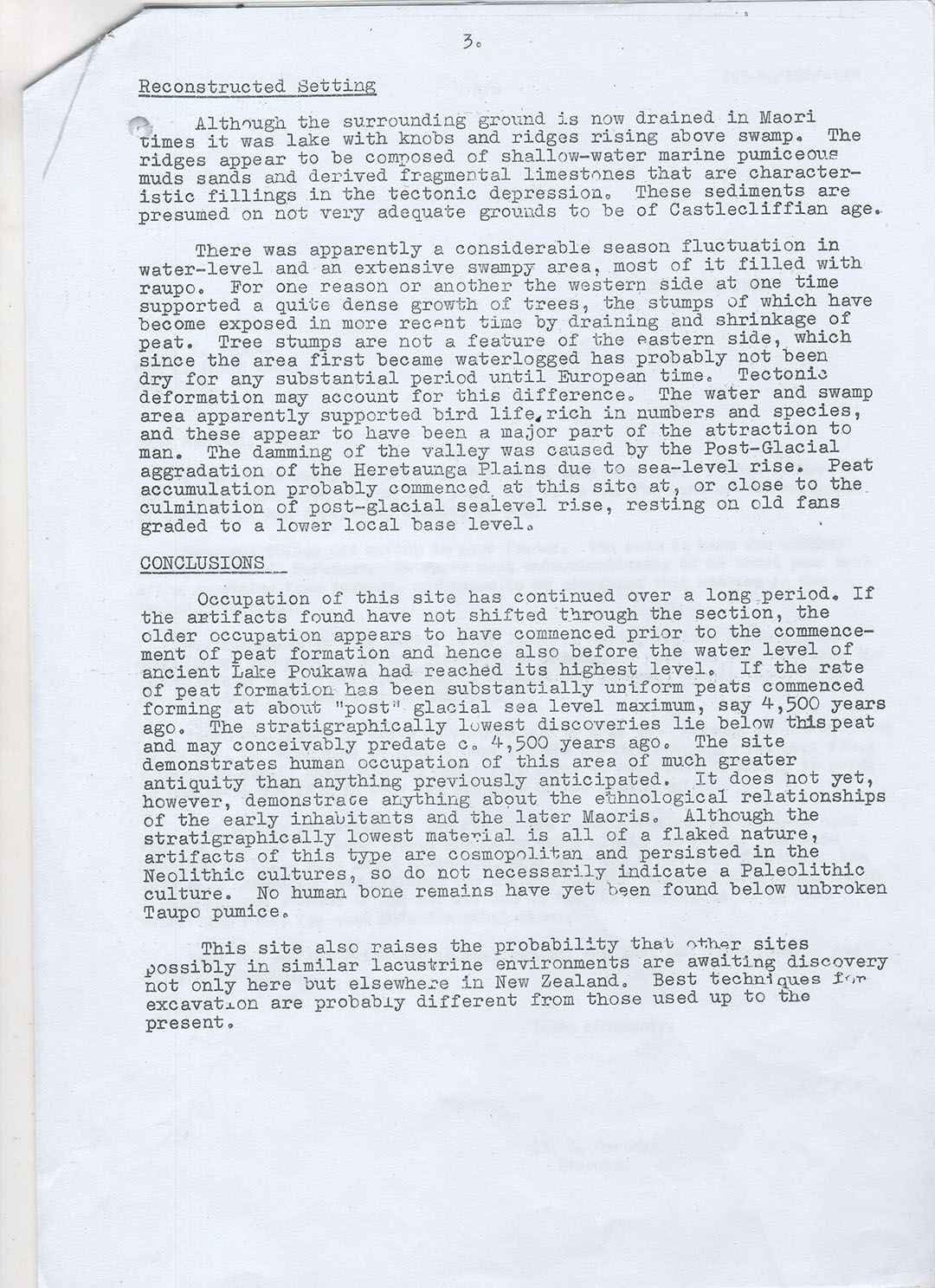
'After discussing a likely geological history of the area, the Statement gets straight into conclusions...'
'Occupation of this site has continued over a long period. The older occupation appears to have commenced prior to the commencement of the peat formation and hence also before the water level of ancient Lake Poukawa had reached its highest level. If the rate of peat formation has been substantially uniform peats commenced forming at about 'post'-glacial sea level maximum, say 4,500 years ago. The stratigraphically lowest discoveries lie below this peat and may conceivably pre-date ca 4,500 years ago'. 'The site demonstrates human occupation of this area of much greater antiquity than anything previously anticipated'.
'It does not yet, however, demonstrate anything about the ethnological relationships of the earlier inhabitants and the later Maoris. Although the stratigraphically lowest material is all of a flaked nature, artefact's of this type are cosmopolitan and persisted in the Neolithic cultures, so do not necessarily indicate a Palaeolithic culture...'
'This is a most interesting document, its chief significance being that four pre-eminent scientists of the day saw fit to formalise their concurred view of the implications of Price's work at Poukawa. There are criticisms of course. And even charges of forgery against the paper. But these charges are baseless and cannot be sustained'.
'According to Price's biographer, Bevan Greenslade...the papers key is 'slowly accumulated'. It indicates patience and care, and a reserve difficult to falsify. Pullar's fortuitous involvement is also commented upon. This ground-breaking geologist was experienced and independent, and it was good to have a reliable bald statement asserting positive, unconditional dated identification of Waimihia and Taupo ash tephra. On the subject of post-holes, scientists of this calibre saying words such as '...convincingly demonstrates human occupation of the site prior to the Taupo shower' is pretty staunch collateral support for Price's own ideas. Such words lifted Price out of the 'misguided or speculative amateur enthusiast' category'.
Enter Dr. Bruce McFadgen and his team [Note: McFadgen was only qualified as a surveyor in 1973 when he did his dig at Poukawa], made up of members of the Victoria University Geological Society and the Wellington Archaeological Society.
'The team dug in an area already dealt with by Price and in his report in the 'Journal of the Royal Society of New Zealand', (Vol. 9, No. 3, 1979, pp 375- 382) McFadgen proceeded to demolish all Price's claims and to make it difficult for anyone else to stand alongside the beleaguered farmer and still retain his or her credibility'.
'Thus, all Price's post holes became 'root channels of old trees'. Disking of the area in the past mixed introduced snails and pig bones with extinct heron and notornis remains, fooling everyone in the process. Tree roots made the 'file marks' noted on some old bones. After the land was raised by the 1931 earthquake and the peat began to dry out, it cracked, and allowed surface material to fall down to sub-ash levels - in every case. The shrinking ground was also responsible for all broken bird bones as well. It was all too pat'.
'McFadgen's conclusion was that 'because the peat is cracked, and things have fallen down the cracks, and because the site has been bulldozed and disked, and artefact's have been disturbed, the Poukawa site does not provide evidence for the antiquity of man in New Zealand, and is extremely misleading'.
He further stated that the site 'was probably occupied between 150 and 300 years ago' and 'there is no evidence for human occupation before the Taupo pumice eruption'.
'Tutored ones who previously wavered, now largely embraced the 'new light' provided by the team, while the public at large - or at least the members of the public interested in such things - jumped the opposite way, taking the view that McFadgen's simplistic dismissal of claims made for Poukawa were a 'jack-up', that he had approached the task of 'dealing with' Poukawa with his mind already made up, and that his conclusions ran counter to all previous indications from the site'. (See: Chain of Evidence, by John Tasker, pgs.138 - 155).
DR ATHOL RAFTER'S COPY OF "THE STATEMENT OF BELIEF" TEXT, ACQUIRED UNDER AN OIA REQUEST FROM THE RAFTER RADIO CARBONDATING LABORATORY.
Whereas the copy held by author John Tasker has the title: Statement of Belief written across the top and is signed by 4 eminent scientists, Rafter's copy contains only the text.
TO UNDERSTAND THE RADICAL POLITICAL CHANGES THAT LED TO RUSSELL PRICE'S WORK BEING DISCREDITED, CLICK HERE